Brazil Google maps and Driving Directions
Get free driving directions, Google maps, traffic information for Brazil, and Brasilia (GPS: 15 47 S 47 55 W), the capital city of the country located in (the) Eastern South America, bordering the Atlantic Ocean.
Find any address in Brasilia on the Google map of Brazil (BR) with ease or calculate your up to date itinerary to and from Brazil or its neighboring counties like Argentina, Bolivia, Colombia, Guyana, Paraguay, Peru, Suriname, Uruguay, Venezuela.
Sightseeing and exploring in America starts here, thanks to Google because its Earth Engine combines a multi-petabyte catalog of updated satellite imagery and geospatial datasets with planetary-scale analysis capabilities. Wonder the world, use the satellite map function of the Google maps to explore or see differences on the Earth’s surface, inland, or the surrounding areas of Brazil.
Google Maps Brazil
Covering almost half of South America, Brazil is the site of the worlds largest and ecologically most important rainforest. The country has immense natural and economic resources.
Brazil is mostly flat to rolling lowlands in north; some plains, hills, mountains, and narrow coastal belt.
The map above fully covers Brazil with its road routes from cities to towns, road intersections in any region, provinces, prefectures, also with free driving directions in Brasilia or to the neighboring towns and countries. To look at the detailed map about a particular quarter in Brasilia, please click on the area and zoom to the place you are interested in the Google maps of Brazil (BR).
Be creative, use the extras of this Google map; This is a detailed, clear, zoomable, large road map of Brazil with its administrative divisions; 26 states (estados, singular – estado) and 1 federal district* (distrito federal); Acre, Alagoas, Amapa, Amazonas, Bahia, Ceara, Distrito Federal*, Espirito Santo, Goias, Maranhao, Mato Grosso, Mato Grosso do Sul, Minas Gerais, Para, Paraiba, Parana, Pernambuco, Piaui, Rio de Janeiro, Rio Grande do Norte, Rio Grande do Sul, Rondonia, Roraima, Santa Catarina, Sao Paulo, Sergipe, Tocantins.
The interactive map above is also may be used as the satellite map of Brazil, or as a reverse search map for finding an address from its GPS coordinates.
Brazil covers nearly half of South America and is the continent’s largest nation. It extends 2,965 mi (4,772 km) north-south, 2,691 mi (4,331 km) east-west, and borders every nation on the continent except Chile and Ecuador. Brazil may be divided into the Brazilian Highlands, or plateau, in the south and the Amazon River Basin in the north. Over a third of Brazil is drained by the Amazon and its more than 200 tributaries. The Amazon is navigable for ocean steamers to Iquitos, Peru, 2,300 mi (3,700 km) upstream. Southern Brazil is drained by the Plata systemthe Paraguay, Uruguay, and Paraná rivers.
Brazil (area: 8 514 880 sq km / 3 287 612,20 sq mi), where the official language is Portuguese, lying in America and using the currency; Brazilian real (BRL), since 1994, set their clock to UTC-3. That means they are 2 hours ahead of Washington DC during Standard Time in Brasilia, the capital. Note to the time difference: Daylight saving time: +1hr begins third Sunday in October; ends third Sunday in February. Note: Brazil has three time zones including one for the Fernando de Noronha Islands.
The climate in Brazil; Brazils share of the Amazon Basin has a model tropical equatorial climate, with high temperatures and rainfall all year round. The Brazilian plateau has far greater seasonal variation. The dry northeast suffers frequent droughts, though coastal regions are occasionally flooded by bouts of torrential rain. The south has hot summers and cool winters.
Geography in a nutshell; Rainforest grows around the massive Amazon River and its delta, covering almost half of Brazils total land area. Apart from the basin of the River Plate to the south, the rest of the country consists of high lands. The mountainous east is part-forested and part-desert. The coastal plain in the southeast has swampy areas. The Atlantic coastline is 1240 miles (2000 km) long.
Click here for more detailed information about Brazil.
Driving directions Brazil
The Google maps and Google Satellite maps of Brazil above showing the country, located next to Argentina, Bolivia, Colombia, Guyana, Paraguay, Peru, Suriname, Uruguay, Venezuela. For your further reference, the latitude and longitude coordinates of Brazil are 10 00 S, 55 00 W , while the capital, Brasilia found at 15 47 S 47 55 W.
When you are traveling around Brazil, Brasilia, or its other cities, use this routing tool, providing up to date route planning service free of charge.
Look no further; get accurate driving directions in Brazil, South America, by filling the route planner form below.
Since Google acquired and introduced its digitalized maps in 2004, you’re probably familiar with its base functions, like finding an address or driving directions to locations. Still, Google maps also accommodate bicyclists, pedestrians, and also public transportation with special directions and customizable routes.
About Brazil and the capital, Brasilia
 |
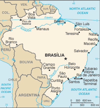 |
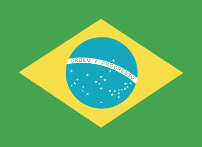
| The national flag of Brazil | Borderline map of Brazil |
| Flag description: green with a large yellow diamond in the center bearing a blue celestial globe with 27 white five-pointed stars; the globe has a white equatorial band with the motto ORDEM E PROGRESSO (Order and Progress); the current flag was inspired by the banner of the former Empire of Brazil (1822-1889); on the imperial flag, the green represented the House of Braganza of Pedro I, the first Emperor of Brazil, while the yellow stood for the Habsburg Family of his wife; on the modern flag the green represents the forests of the country and the yellow rhombus its mineral wealth (the diamond shape roughly mirrors that of the country); the blue circle and stars, which replaced the coat of arms of the original flag, depict the sky over Rio de Janeiro on the morning of 15 November 1889 – the day the Republic of Brazil was declared; the number of stars has changed with the creation of new states and has risen from an original 21 to the current 27 (one for each state and the Federal District). Note: one of several flags where a prominent component of the design reflects the shape of the country; other such flags are those of Bosnia and Herzegovina, Eritrea, and Vanuatu. | Border length: total: 16,145 km. Border countries (total: 10): Argentina 1,263 km, Bolivia 3,403 km, Colombia 1,790 km, French Guiana 649 km, Guyana 1,308 km, Paraguay 1,371 km, Peru 2,659 km, Suriname 515 km, Uruguay 1,050 km, Venezuela 2,137 km. |
About Brasília
There are other planned cities in the world – Washington, D.C., Chandigarh, Canberra – but none have the daring and sheer vision of Brasília. In the 1950s, a country that had shucked off a failed monarchy, a corrupt republic, and a police-state dictatorship decided to make a clean break from the past by creating a brand-new space for politics. The style they chose was Modernism. Brazil blessed with some of the foremost practitioners in the world. The city plan was done by Lucio Costa. The buildings were designed by Oscar Niemeyer.
The site, on Brazil’s high interior plateau, was nothing but cerrado – short scrubby forest, stretching thousands of miles in every direction. It was nearly 400 miles from the nearest paved road, over 75 miles from the nearest railroad, 120 miles from the nearest airport.
Groundbreaking began in 1957, and by April 21, 1960, there was enough of a city for a grand inauguration. In place of a grid, there were but two high intersecting streets, one straight, one curved. Viewed from on top, the city looked bold and monumental – like an airplane in flight, or an arrow shooting forward into the future.
Over the years, Brasília has been a source of controversy. Urbanists were beginning to doubt the rationality of rationalist Modern planning. Cities, it was being discovered, were vital, growing, entities, whose real complexity could perhaps never encompassed in a single master plan. For visitors, the attractions here are purely architectural. Brazil’s best designers, architects, and artists commissioned to create the monuments and buildings and make them beautiful. A visit to Brasília is a chance to see and judge their success.
Did you know about Brazil?
- Brazil belonged to Portugal until 1822 when it became an independent kingdom, and later an empire. It formed a federal republic in 1889.
- Since 1900, a third of Brazils indigenous Amerindian groups have become extinct due to disease, starvation, or the forceful taking of land by miners, loggers, and settlers.
- Big Brazil is home to a highly diverse population of more than 179 million people. It is thought to be named after the native brazilwood tree.
Brazil is a vast country that occupies nearly half the landmass of South America. There are two dominant topographical features – the great Amazon river basin and the ancient plateau region of crystalline rocks called the Brazilian Highlands. In the central interior, the Highlands form a raised tableland called the Mato Grosso, and throughout their extent, they are cut by deep river valleys and ridged by mountain ranges.
In the far north, beyond the Amazon basin, lies the southern upland extremity of the Guiana Highlands, another region of very ancient rocks. The Amazon system is navigable by large oceangoing vessels for about 3,700 kilometers or 2,300 miles, a factor that has been of immense importance to the development of Brazil.
Agriculture has always played a leading part in the Brazilian economy, but Brazil’s mineral resources of iron ore, gold, bauxite, tin, petroleum, and natural gas, copper, manganese, silver, titanium, zinc, chromium and quartz have been increasingly exploited since the 1970s. Brazil has valuable timber reserves, but there has been worldwide concern over the ruthless and unregulated felling and clearing of vast sections of rainforest.

Facts of Brazil (BR)
Name conventional long form: Federative Republic of Brazil, conventional short form: Brazil, local long form: Republica Federativa do Brasil, local short form: Brasil, etymology: the country name derives from the brazilwood tree that used to grow plentifully along the coast of Brazil and that was used to produce a deep red dye
Codes: ISO; BR, Internet; .br
Capital city: Brasilia
Language(s): Portuguese (official language and most widely spoken language). Note: less common languages include Spanish (border areas and schools), German, Italian, Japanese, English, and a large number of minor Amerindian languages
National holiday(s): Independence Day, 7 September (1822)
Motto: Ordem e Progresso (Order and Progress)
Currency: Brazilian real (BRL), since 1994
GPS: 10 00 S, 55 00 W, Brasilia; 15 47 S 47 55 W
Location: Eastern South America, bordering the Atlantic Ocean
Geography note: largest country in South America and in the Southern Hemisphere; shares common boundaries with every South American country except Chile and Ecuador
Land boundaries: Argentina 1,263 km, Bolivia 3,403 km, Colombia 1,790 km, French Guiana 649 km, Guyana 1,308 km, Paraguay 1,371 km, Peru 2,659 km, Suriname 515 km, Uruguay 1,050 km, Venezuela 2,137 km, total: 16,145 km
Maritime boundaries: N/A
Coastline: 7,491 km
Area: total: 8,515,770 sq km; land: 8,358,140 sq km, water: 157,630 sq km (total 3 287 612,20 mi2), slightly smaller than the US.
Roadways: total: 1,580,964 km, paved: 212,798 km, unpaved: 1,368,166 km, note: does not include urban roads (2010)
Waterways: 50,000 km (most in areas remote from industry and population) (2012)
Local time (capital): UTC-3, 2 hours ahead of Washington DC during Standard Time
Note to the local time: Daylight saving time: +1hr begins third Sunday in October; ends third Sunday in February. Note: Brazil has three time zones including one for the Fernando de Noronha Islands
Population in Brazil: 210 867 954
Population in Brasilia: 2 160 100 (including the metropolitan areas)
Urbanization: urban population: 85.7% of total population (2015)
Major urban areas population: Sao Paulo 21.066 million; Rio de Janeiro 12.902 million; Belo Horizonte 5.716 million; BRASILIA (capital) 4.155 million; Fortaleza 3.88 million; Recife 3.739 million (2015)
Population growth rate: 0.75% (2016 estimate)
Birth rate: 14.3 births / 1,000 population (2016 estimate)
Death rate: 6.6 deaths / 1,000 population (2016 estimate)
Age structure: 0-14 years: 22.79% (male 23,905,185 / female 22,994,222) 15-24 years: 16.43% (male 17,146,060 / female 16,661,163) 25-54 years: 43.84% (male 44,750,568 / female 45,489,430) 55-64 years: 8.89% (male 8,637,011 / female 9,656,370) 65 years and over: 8.06% (male 7,059,944 / female 9,523,712) (2016 estimate)
Median age: total: 31.6 years; male: 30.7 years, female: 32.4 years (2016 estimate)
Ethnic groups: white 47.7%, mulatto (mixed white and black) 43.1%, black 7.6%, Asian 1.1%, indigenous 0.4% (2010 estimate)
Religions: Roman Catholic 64.6%, other Catholic 0.4%, Protestant 22.2% (includes Adventist 6.5%, Assembly of God 2.0%, Christian Congregation of Brazil 1.2%, Universal Kingdom of God 1.0%, other Protestant 11.5%), other Christian 0.7%, Spiritist 2.2%, other 1.4%, none 8%, unspecified 0.4% (2010 estimate)
Government type: Federal presidential constitutional republic
Legal system: civil law; note – a new civil law code was enacted in 2002 replacing the 1916 code
National anthem: Hino Nacional Brasileiro (Brazilian National Anthem)
Known national hazards: recurring droughts in northeast; floods and occasional frost in south
Major infectious diseases: The The degree of risk(s): very high food or waterborne diseases: bacterial diarrhea and hepatitis A vectorborne diseases: dengue fever and malariawater contact disease: schistosomiasis. Note: active local transmission of Zika virus by Aedes species mosquitoes has been identified in this country (as of August 2016); it poses an important risk (a large number of cases possible) among US citizens if bitten by an infective mosquito; other less common ways to get Zika are through sex, via blood transfusion, or during pregnancy, in which the pregnant woman passes Zika virus to her fetus (2016)
Land use: agricultural land: 32.9%; arable land 8.6%; permanent crops 0.8%; permanent pasture 23.5%; forest: 61.9%; other: 5.2% (2011 estimate)
Agricultural products: coffee, soybeans, wheat, rice, corn, sugarcane, cocoa, citrus; beef
Industries: textiles, shoes, chemicals, cement, lumber, iron ore, tin, steel, aircraft, motor vehicles and parts, other machinery and equipment
Export commodities: transport equipment, iron ore, soybeans, footwear, coffee, automobiles
Main export partners: China 18.6%, US 12.7%, Argentina 6.7%, Netherlands 5.3% (2015)
Import commodities: machinery, electrical and transport equipment, chemical products, oil, automotive parts, electronics
Main import partners: China 17.9%, US 15.6%, Germany 6.1%, Argentina 6% (2015)
Navigate the countries in South America faster and easier while driving, use the interactive Google maps for your driving directions. The continuously updated database contains over 220 countries and territories digitally mapped, hundreds of millions of businesses and places around the world positioned on the map.
Get fresh GPS navigation, traffic, and transit information – no matter what part of Brazil, Brasilia, any other city and country in America, or the world you’re in.
Do you like this Brazil information page? Please don’t forget to share it with others! Thank you.