Afghanistan Google maps and Driving Directions
Get free driving directions, Google maps, traffic information for Afghanistan, and Kabul (GPS: 34 31 N 69 11 E), the capital city of the country located in (the) Southern Asia, north and west of Pakistan, east of Iran.
Find any address in Kabul on the Google map of Afghanistan (AF) with ease or calculate your up to date itinerary to and from Afghanistan or its neighboring counties like China, Iran, Pakistan, Tajikistan, Turkmenistan, Uzbekistan.
Sightseeing and exploring in Asia starts here, thanks to Google because its Earth Engine combines a multi-petabyte catalog of updated satellite imagery and geospatial datasets with planetary-scale analysis capabilities. Wonder the world, use the satellite map function of the Google maps to explore or see differences on the Earth’s surface, inland, or the surrounding areas of Afghanistan.
Google Maps Afghanistan
About 75% of this landlocked Asian country is inaccessible. The Islamist Taliban, ousted in 2001, continue to fight a guerrilla war against Afghan and NATO-led forces.
Afghanistan is mostly rugged mountains; plains in north and southwest.
The map above fully covers Afghanistan with its road routes from cities to towns, road intersections in any region, provinces, prefectures, also with free driving directions in Kabul or to the neighboring towns and countries. To look at the detailed map about a particular quarter in Kabul, please click on the area and zoom to the place you are interested in the Google maps of Afghanistan (AF).
Be creative, use the extras of this Google map; This is a detailed, clear, zoomable, large road map of Afghanistan with its administrative divisions; 34 provinces (welayat, singular – welayat); Badakhshan, Badghis, Baghlan, Balkh, Bamyan, Daykundi, Farah, Faryab, Ghazni, Ghor, Helmand, Herat, Jowzjan, Kabul, Kandahar, Kapisa, Khost, Kunar, Kunduz, Laghman, Logar, Nangarhar, Nimroz, Nuristan, Paktika, Paktiya, Panjshir, Parwan, Samangan, Sar-e Pul, Takhar, Uruzgan, Wardak, Zabul.
The interactive map above is also may be used as the satellite map of Afghanistan, or as a reverse search map for finding an address from its GPS coordinates.
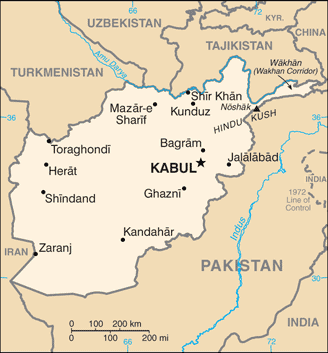
Afghanistan, approximately the size of Texas, is bordered on the north by Turkmenistan, Uzbekistan, and Tajikistan, on the extreme northeast by China, on the east and south by Pakistan, and by Iran on the west. The country is split east to west by the Hindu Kush mountain range, rising in the east to heights of 24,000 ft (7,315 m). With the exception of the southwest, most of the country is covered by high snow-capped mountains and is traversed by deep valleys.
Afghanistan (area: 652 090 sq km / 251 773,25 sq mi), where the official language is Dari, Pashto, lying in Asia and using the currency; Afghan afghani (AFN), since 2002, set their clock to UTC+4.5. That means they are 9.5 hours ahead of Washington DC during Standard Time in Kabul, the capital. Note to the time difference: N/A.
The climate in Afghanistan; Harsh continental. Hot, dry summers. Cold winters with heavy snow, especially in the Hindu Kush.
Geography in a nutshell; Predominantly mountainous. Highest range is the Hindu Kush. Mountains are bordered by fertile plains. Desert plateau in the south.
Click here for more detailed information about Afghanistan.
Driving directions Afghanistan
The Google maps and Google Satellite maps of Afghanistan above showing the country, located next to China, Iran, Pakistan, Tajikistan, Turkmenistan, Uzbekistan. For your further reference, the latitude and longitude coordinates of Afghanistan are 33 00 N, 65 00 E , while the capital, Kabul found at 34 31 N 69 11 E.
When you are traveling around Afghanistan, Kabul, or its other cities, use this routing tool, providing up to date route planning service free of charge.
Look no further; get accurate driving directions in Afghanistan, Asia, by filling the route planner form below.
Since Google acquired and introduced its digitalized maps in 2004, you’re probably familiar with its base functions, like finding an address or driving directions to locations. Still, Google maps also accommodate bicyclists, pedestrians, and also public transportation with special directions and customizable routes.
About Afghanistan and the capital, Kabul
 |
 |
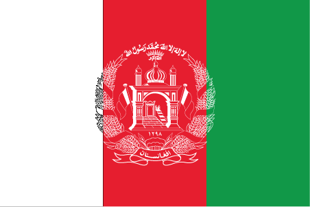
| The national flag of Afghanistan | Borderline map of Afghanistan |
| Flag description: three equal vertical bands of black (hoist side), red, and green, with the national emblem in white centered on the red band and slightly overlapping the other two bands; the center of the emblem features a mosque with pulpit and flags on either side, below the mosque are numerals for the solar year 1298 (1919 in the Gregorian calendar, the year of Afghan independence from the UK); this central image is circled by a border consisting of sheaves of wheat on the left and right, in the upper-center is an Arabic inscription of the Shahada (Muslim creed) below which are rays of the rising sun over the Takbir (Arabic expression meaning “God is great”), and at bottom center is a scroll bearing the name Afghanistan; black signifies the past, red is for the bloodshed for independence, and green can represent either hope for the future, agricultural prosperity, or Islam. Note: Afghanistan had more changes to its national flag in the 20th century than any other country; the colors black, red, and green appeared on most of them. | Border length: total: 5,987 km. Border countries (total: 6): China 91 km, Iran 921 km, Pakistan 2,670 km, Tajikistan 1,357 km, Turkmenistan 804 km, Uzbekistan 144 km. |
Did you know about Afghanistan?
- Afghanistan has had a troubled history. This is shown by the no less than 14 distinct national flags it has used in the 20th and 21st centuries.
- The UN estimates that it could take 100 years to remove the 10 million landmines laid since 1979.
- The different groups of peoples that live in Afghanistan traditionally have their own distinguishable hats.
Facts of Afghanistan (AF)
Name conventional long form: Islamic Republic of Afghanistan, conventional short form: Afghanistan, local long form: Jamhuri-ye Islami-ye Afghanistan, local short form: Afghanistan, former: Republic of Afghanistan, etymology: the name “Afghan” originally referred to the Pashtun people (today it is understood to include all the country’s ethnic groups), while the suffix “-stan” means “place of” or “country”; so Afghanistan literally means the “Land of the Afghans”
Codes: ISO; AF, Internet; .af
Capital city: Kabul
Language(s): Afghan Persian or Dari (official language language) 50%, Pashto (official language language) 35%, Turkic languages (primarily Uzbek and Turkmen) 11%, 30 minor languages (primarily Balochi and Pashai) 4%, much bilingualism, but Dari functions as the lingua franca. Note: the Turkic languages Uzbek and Turkmen, as well as Balochi, Pashai, Nuristani, and Pamiri are the third official language language languages in areas where the majority speaks them
National holiday(s): Independence Day, 19 August (1919)
Motto: There is no god but God. Muhammad is the messenger of God
Currency: Afghan afghani (AFN), since 2002
GPS: 33 00 N, 65 00 E, Kabul; 34 31 N 69 11 E
Location: Southern Asia, north and west of Pakistan, east of Iran
Geography note: landlocked country; the Hindu Kush mountains that run northeast to southwest divide the northern provinces from the rest of the country; the highest peaks are in the northern Vakhan (Wakhan Corridor)
Land boundaries: China 91 km, Iran 921 km, Pakistan 2,670 km, Tajikistan 1,357 km, Turkmenistan 804 km, Uzbekistan 144 km, total: 5,987 km
Maritime boundaries: N/A
Coastline: 0 km (landlocked country)
Area: total: 652,230 sq km; land: 652,230 sq km, water: 0 sq km (total 251 773,25 mi2), almost six times the size of Virginia; slightly smaller than Texas.
Roadways: total: 42,150 km, paved: 12,350 km, unpaved: 29,800 km (2006)
Waterways: 1,200 km; (chiefly Amu Darya, which handles vessels up to 500 DWT) (2011)
Local time (capital): UTC+4.5, 9.5 hours ahead of Washington DC during Standard Time
Note to the local time: N/A
Population in Afghanistan: 36 373 176
Population in Kabul: 2 206 300 (including the metropolitan areas)
Urbanization: urban population: 26.7% of total population (2015)
Major urban areas population: KABUL (capital) 4.635 million (2015)
Population growth rate: 2.34% (2016 estimate)
Birth rate: 38.3 births / 1,000 population (2016 estimate)
Death rate: 13.7 deaths / 1,000 population (2016 estimate)
Age structure: 0-14 years: 41.03% (male 6,947,939 / female 6,728,983) 15-24 years: 22.49% (male 3,816,369 / female 3,678,657) 25-54 years: 30.01% (male 5,095,905 / female 4,907,019) 55-64 years: 3.9% (male 640,813 / female 660,121) 65 years and over: 2.57% (male 396,124 / female 460,095) (2016 estimate)
Median age: total: 18.6 years; male: 18.5 years, female: 18.6 years (2016 estimate)
Ethnic groups: Pashtun, Tajik, Hazara, Uzbek, other (includes smaller numbers of Baloch, Turkmen, Nuristani, Pamiri, Arab, Gujar, Brahui, Qizilbash, Aimaq, Pashai, and Kyrghyz). Note: current statistical data on the sensitive subject of ethnicity in Afghanistan is not available, and ethnicity data from small samples of respondents to opinion polls are not a reliable alternative; Afghanistan’s 2004 constitution recognizes 14 ethnic groups: Pashtun, Tajik, Hazara, Uzbek, Baloch, Turkmen, Nuristani, Pamiri, Arab, Gujar, Brahui, Qizilbash, Aimaq, and Pashai (2015)
Religions: Muslim 99.7% (Sunni 84.7 – 89.7%, Shia 10 – 15%), other 0.3% (2009 estimate)
Government type: Unitary presidential Islamic republic
Legal system: mixed legal system of civil, customary, and Islamic law
National anthem: The National Anthem
Known national hazards: damaging earthquakes occur in Hindu Kush mountains; flooding; droughts
Major infectious diseases: The degree of risk(s): intermediatefood or waterborne diseases: bacterial diarrhea, hepatitis A, and typhoid fever vectorborne disease: malaria (2016)
Land use: agricultural land: 58.1%; arable land 11.9%; permanent crops 0.2%; permanent pasture 46%; forest: 2.1%; other: 39.8% (2011 estimate)
Agricultural products: opium, wheat, fruits, nuts; wool, mutton, sheepskins, lambskins, poppies
Industries: small-scale production of bricks, textiles, soap, furniture, shoes, fertilizer, apparel, food products, non-alcoholic beverages, mineral water, cement; handwoven carpets; natural gas, coal, copper
Export commodities: opium, fruits and nuts, handwoven carpets, wool, cotton, hides and pelts, precious and semi-precious gems
Main export partners: India 42.3%, Pakistan 29%, Tajikistan 7.6% (2015)
Import commodities: machinery and other capital goods, food, textiles, petroleum products
Main import partners: Pakistan 38.6%, India 8.9%, US 8.3%, Turkmenistan 6.2%, China 6%, Kazakhstan 5.9%, Azerbaijan 4.9% (2015)
Navigate the countries in Asia faster and easier while driving, use the interactive Google maps for your driving directions. The continuously updated database contains over 220 countries and territories digitally mapped, hundreds of millions of businesses and places around the world positioned on the map.
Get fresh GPS navigation, traffic, and transit information – no matter what part of Afghanistan, Kabul, any other city and country in Asia, or the world you’re in.
Do you like this Afghanistan information page? Please don’t forget to share it with others! Thank you.