Bosnia and Herzegovina Google maps and Driving Directions
Get free driving directions, Google maps, traffic information for Bosnia and Herzegovina, and Sarajevo (GPS: 43 52 N 18 25 E), the capital city of the country located in (the) Southeastern Europe, bordering the Adriatic Sea and Croatia.
Find any address in Sarajevo on the Google map of Bosnia and Herzegovina (BA) with ease or calculate your up to date itinerary to and from Bosnia and Herzegovina or its neighboring counties like Croatia, Montenegro, Serbia.
Sightseeing and exploring in Europe starts here, thanks to Google because its Earth Engine combines a multi-petabyte catalog of updated satellite imagery and geospatial datasets with planetary-scale analysis capabilities. Wonder the world, use the satellite map function of the Google maps to explore or see differences on the Earth’s surface, inland, or the surrounding areas of Bosnia and Herzegovina.
Google Maps Bosnia and Herzegovina
Perched in the highlands of southeast Europe, Bosnia and Herzegovina were the focus of the bitter ethnic conflict which accompanied the early 1990s dissolution of the Yugoslav state.
Bosnia and Herzegovina is mountains and valleys.
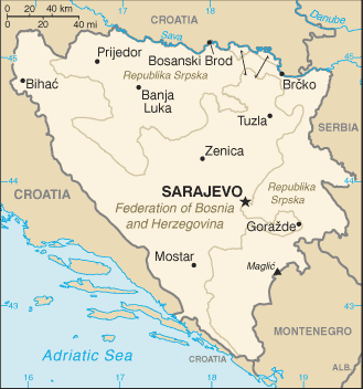
The map above fully covers Bosnia and Herzegovina with its road routes from cities to towns, road intersections in any region, provinces, prefectures, also with free driving directions in Sarajevo or to the neighboring towns and countries. To look at the detailed map about a particular quarter in Sarajevo, please click on the area and zoom to the place you are interested in the Google maps of Bosnia and Herzegovina (BA).
Be creative, use the extras of this Google map; This is a detailed, clear, zoomable, large road map of Bosnia and Herzegovina with its administrative divisions; 2 first-order administrative divisions and 1 internationally supervised district* – the Federation of Bosnia and Herzegovina (Federacija Bosne i Hercegovine) (predominantly Bosniak-Croat), the Republika Srpska (predominately Serb), Brcko District (Brcko Distrikt)*; note – Brcko District is in northeastern Bosnia and is a self-governing administrative unit under the sovereignty of Bosnia and Herzegovina and formally held in condominium between the two entities.
The interactive map above is also may be used as the satellite map of Bosnia and Herzegovina, or as a reverse search map for finding an address from its GPS coordinates.
Bosnia and Herzegovina make up a triangular-shaped republic, about half the size of Kentucky, on the Balkan peninsula. The Bosnian region in the north is mountainous and covered with thick forests. The Herzegovina region in the south is largely rugged, flat farmland. It has a narrow coastline without natural harbors stretching 13 mi (20 km) along the Adriatic Sea.
Bosnia and Herzegovina (area: 51 197 sq km / 19 767,26 sq mi), where the official language is Bosnian, Croatian, Serbian, lying in Europe and using the currency; Bosnia and Herzegovina convertible mark (BAM), set their clock to UTC+1. That means they are 6 hours ahead of Washington DC during Standard Time in Sarajevo, the capital. Note to the time difference: Daylight saving time: +1hr begins last Sunday in March; ends last Sunday in October.
The climate in Bosnia and Herzegovina; Continental. Hot summers and cold, often snowy winters.
Geography in a nutshell; Hills and mountains, with narrow river valleys. Lowlands in the north. Mainly deciduous forest covers about half of the total area.
Click here for more detailed information about Bosnia and Herzegovina.
Driving directions Bosnia and Herzegovina
The Google maps and Google Satellite maps of Bosnia and Herzegovina above showing the country, located next to Croatia, Montenegro, Serbia. For your further reference, the latitude and longitude coordinates of Bosnia and Herzegovina are 44 00 N, 18 00 E , while the capital, Sarajevo found at 43 52 N 18 25 E.
When you are traveling around Bosnia and Herzegovina, Sarajevo, or its other cities, use this routing tool, providing up to date route planning service free of charge.
Look no further; get accurate driving directions in Bosnia and Herzegovina, Europe, by filling the route planner form below.
Since Google acquired and introduced its digitalized maps in 2004, you’re probably familiar with its base functions, like finding an address or driving directions to locations. Still, Google maps also accommodate bicyclists, pedestrians, and also public transportation with special directions and customizable routes.
About Bosnia and Herzegovina and the capital, Sarajevo
 |
 |
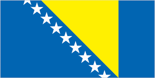
| The national flag of Bosnia and Herzegovina | Borderline map of Bosnia and Herzegovina |
| Flag description: a wide medium blue vertical band on the fly side with a yellow isosceles triangle abutting the band and the top of the flag; the remainder of the flag is medium blue with seven full five-pointed white stars and two half stars top and bottom along the hypotenuse of the triangle; the triangle approximates the shape of the country, and its three points stand for the constituent peoples – Bosniaks, Croats, and Serbs; the stars represent Europe and are meant to be continuous (thus the half stars at top and bottom); the colors (white, blue, and yellow) are often associated with neutrality and peace, and traditionally are linked with Bosnia. Note: one of several flags where a prominent component of the design reflects the shape of the country; other such flags are those of Brazil, Eritrea, and Vanuatu. | Border length: total: 1,543 km. Border countries (total: 3): Croatia 956 km, Montenegro 242 km, Serbia 345 km. |
About Sarajevo
With their imaginations and travel memories fired by spiky minarets, grilled kebabs, and the all-pervasive aroma of ground coffee, many travelers see in Sarajevo a Slavic mini-Istanbul. The Ottoman notes are most prominent in Baščaršija, the city’s delightful Old Town, which is home to umpteen mosques, bazaars, kebab restaurants and cafés. Further afield, burnt-out buildings evoke the catastrophic war of the mid-1990s. However, the fun-loving, easy-going Sarajevans do a great job of painting over the scars of those tumultuous years – it’s hard to walk around without being offered coffee, and it’s hard to be invited for coffee without making friends.
Sarajevo gained importance during Roman times, and after a short slumber reinvigorated as a trading hub during the Ottoman period, but sadly its recent history is far more pertinent. The international spotlight fell on the city as the host of the 1984 Winter Olympics. Still, less than a decade later, the world’s eyes were retrained on it during a siege that lasted for almost four years – by some estimates, the longest in military history. Bosnian Serb forces made a near-unbroken ring around the city, shelling significant buildings and shooting civilians dead on their way to work, while years of litter lay rotting in the streets. By the time the ceasefire was announced in 1996, around ten thousand people killed; on the ground, you may notice some of the many Sarajevo Roses – flower-like scars of mortar shell explosions, poignantly filled in with red resin, though now severely fading.
Did you know about Bosnia and Herzegovina?
- Bosnia-Herzegovina was under Turkish rule until it was ceded to Austria in 1878. From 1945 to 1992 it formed part of Yugoslavia.
- The murder of Archduke Ferdinand of Austria in Sarajevo in 1914 triggered the First World War.
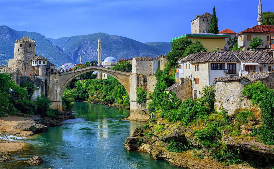
- Originally built in 1566 and traditionally used as a diving platform for young men to prove their bravery, Bosnias famous Mostar Bridge restored in 1994.
Bosnia-Herzegovina, more commonly known as Bosnia, declared its independence from the former Yugoslavia in 1992 and became the scene of bitter ethnic fighting in the years that followed. Its capital is Sarajevo.
Most of the country is mountainous, with ranges of the Dinaric Alps being the principal topographical feature in the west and south. The limestone plateau further to the east and the north is a second prominent feature while the northern strip of the country is lower-lying and densely forested.
The country possesses valuable mineral resources including coal, iron ore, manganese, lead, copper, and silver and has vast potential for the development of hydroelectric power. The main industries are agriculture, mining, manufacturing, and forestry but the economy has suffered greatly because of the fighting in the country.
Facts of Bosnia and Herzegovina (BA)
Name conventional long form: none, conventional short form: Bosnia and Herzegovina, local long form: none, local short form: Bosna i Hercegovina, former: People’s Republic of Bosnia and Herzegovina, Socialist Republic of Bosnia and Herzegovinaabbreviation: BiH, etymology: the larger northern territory named for the Bosna River; the smaller southern section takes its name from the German word “herzog,” meaning “duke,” and the ending “-ovina,” meaning “land,” forming the combination denoting “dukedom”
Codes: ISO; BA, Internet; .ba
Capital city: Sarajevo
Language(s): Bosnian (official language) 52.9%, Serbian (official language) 30.8%, Croatian (official language) 14.6%, other 1.6%, no answer 0.2% (2013 estimate)
National holiday(s): National Day (Statehood Day), 25 November (1943); Independence Day, 1 March (1992)
Motto: N/A
Currency: Bosnia and Herzegovina convertible mark (BAM)
GPS: 44 00 N, 18 00 E, Sarajevo; 43 52 N 18 25 E
Location: Southeastern Europe, bordering the Adriatic Sea and Croatia
Geography note: within Bosnia and Herzegovina’s recognized borders, the country divided into a joint Bosniak/Croat Federation (about 51% of the territory), and the Bosnian Serb-led Republika Srpska or RS (about 49% of the territory); the region called Herzegovina is contiguous to Croatia and Montenegro, and traditionally has been settled by an ethnic Croat majority in the west and an ethnic Serb majority in the east
Land boundaries: Croatia 956 km, Montenegro 242 km, Serbia 345 km, total: 1,543 km
Maritime boundaries: Adriatic Sea
Coastline: 20 km
Area: total: 51,197 sq km; land: 51,187 sq km, water: 10 sq km (total 19 767,26 mi2), slightly smaller than West Virginia.
Roadways: total: 22,926 km, paved: 19,426 km (4,652 km of interurban roads), unpaved: 3,500 km (2010)
Waterways: (Sava River on northern border; open to shipping but use limited) (2011)
Local time (capital): UTC+1, 6 hours ahead of Washington DC during Standard Time
Note to the local time: Daylight saving time: +1hr begins last Sunday in March; ends last Sunday in October
Population in Bosnia and Herzegovina: 3 503 554
Population in Sarajevo: 581 500 (including the metropolitan areas)
Urbanization: urban population: 39.8% of total population (2015)
Major urban areas population: SARAJEVO (capital) 318,000 (2015)
Population growth rate: -0.14% (2016 estimate)
Birth rate: 8.8 births / 1,000 population (2016 estimate)
Death rate: 9.9 deaths / 1,000 population (2016 estimate)
Age structure: 0-14 years: 13.36% (male 266,389 / female 249,425) 15-24 years: 11.97% (male 238,682 / female 223,599) 25-54 years: 46.2% (male 896,760 / female 887,407) 55-64 years: 14.43% (male 267,628 / female 289,464) 65 years and over: 14.05% (male 212,574 / female 329,984) (2016 estimate)
Median age: total: 41.7 years; male: 40.2 years, female: 43.1 years (2016 estimate)
Ethnic groups: Bosniak 50.1%, Serb 30.8%, Croat 15.4%, other 2.7%, not declared/no answer 1%note: the methodology remains disputed and Republika Srspka authorities refuse to recognize the results; Bosniak has replaced Muslim as an ethnic term in part to avoid confusion with the religious term Muslim – an adherent of Islam (2013 estimate)
Religions: Muslim 50.7%, Orthodox 30.7%, Roman Catholic 15.2%, atheist 0.8%, agnostic 0.3%, other 1.2%, undeclared/no answer 1.1% (2013 estimate)
Government type: Federal parliamentary republic
Legal system: civil law system; Constitutional Court review of legislative acts
National anthem: Intermeco
Known national hazards: destructive earthquakes
Major infectious diseases: N/A
Land use: agricultural land: 42.2%; arable land 19.7%; permanent crops 2%; permanent pasture 20.5%; forest: 42.8%; other: 15% (2011 estimate)
Agricultural products: wheat, corn, fruits, vegetables; livestock
Industries: steel, coal, iron ore, lead, zinc, manganese, bauxite, aluminum, motor vehicle assembly, textiles, tobacco products, wooden furniture, ammunition, domestic appliances, oil refining
Export commodities: metals, clothing, wood products
Main export partners: Slovenia 16.5%, Italy 15.9%, Germany 12.1%, Croatia 11.5%, Austria 11.1%, Turkey 5.2% (2015)
Import commodities: machinery and equipment, chemicals, fuels, foodstuffs
Main import partners: Croatia 19.3%, Germany 13.9%, Slovenia 13.8%, Italy 10.9%, Austria 5.7%, Hungary 5.2%, Turkey 4.5% (2015)
Navigate the countries in Europe faster and easier while driving, use the interactive Google maps for your driving directions. The continuously updated database contains over 220 countries and territories digitally mapped, hundreds of millions of businesses and places around the world positioned on the map.
Get fresh GPS navigation, traffic, and transit information – no matter what part of Bosnia and Herzegovina, Sarajevo, any other city and country in Europe, or the world you’re in.
Do you like this Bosnia and Herzegovina information page? Please don’t forget to share it with others! Thank you.