Eritrea Google maps and Driving Directions
Get free driving directions, Google maps, traffic information for Eritrea, and Asmara (GPS: 15 20 N 38 56 E), the capital city of the country located in (the) Eastern Africa, bordering the Red Sea, between Djibouti and Sudan.
Find any address in Asmara on the Google map of Eritrea (ER) with ease or calculate your up to date itinerary to and from Eritrea or its neighboring counties like Djibouti, Ethiopia, Sudan.
Sightseeing and exploring in Africa starts here, thanks to Google because its Earth Engine combines a multi-petabyte catalog of updated satellite imagery and geospatial datasets with planetary-scale analysis capabilities. Wonder the world, use the satellite map function of the Google maps to explore or see differences on the Earth’s surface, inland, or the surrounding areas of Eritrea.
Google Maps Eritrea
Lying along the southwest shore of the Red Sea, Eritrea won a long war for independence from Ethiopia in 1993. The two neighbors fought a bitter border war in 19982000.
Eritrea is dominated by extension of Ethiopian north-south trending highlands, descending on the east to a coastal desert plain, on the northwest to hilly terrain and on the southwest to flat-to-rolling plains.
The map above fully covers Eritrea with its road routes from cities to towns, road intersections in any region, provinces, prefectures, also with free driving directions in Asmara or to the neighboring towns and countries. To look at the detailed map about a particular quarter in Asmara, please click on the area and zoom to the place you are interested in the Google maps of Eritrea (ER).
Be creative, use the extras of this Google map; This is a detailed, clear, zoomable, large road map of Eritrea with its administrative divisions; 6 regions (zobatat, singular – zoba); Anseba, Debub (South), Debubawi K’eyih Bahri (Southern Red Sea), Gash Barka, Ma’akel (Central), Semenawi Keyih Bahri (Northern Red Sea).
The interactive map above is also may be used as the satellite map of Eritrea, or as a reverse search map for finding an address from its GPS coordinates.
Eritrea was formerly the northernmost province of Ethiopia and is about the size of Indiana. Much of the country is mountainous. Its narrow Red Sea coastal plain is one of the hottest and driest places in Africa. The cooler central highlands have fertile valleys that support agriculture. Eritrea is bordered by the Sudan on the north and west, the Red Sea on the north and east, and Ethiopia and Djibouti on the south.
Eritrea (area: 117 600 sq km / 45 405,60 sq mi), where the official language is Arabic, English, Tigrinya, lying in Africa and using the currency; Eritrean nakfa (ERN), since 1997, set their clock to UTC+3. That means they are 8 hours ahead of Washington DC during Standard Time in Asmara, the capital. Note to the time difference: N/A.
The climate in Eritrea; Warm in the mountains; desert areas are hot. Droughts from July onward are common.
Geography in a nutshell; Mostly consists of rugged mountains, bush, and the Danakil Desert, which falls below sea level.
Click here for more detailed information about Eritrea.
Driving directions Eritrea
The Google maps and Google Satellite maps of Eritrea above showing the country, located next to Djibouti, Ethiopia, Sudan. For your further reference, the latitude and longitude coordinates of Eritrea are 15 00 N, 39 00 E , while the capital, Asmara found at 15 20 N 38 56 E.
When you are traveling around Eritrea, Asmara, or its other cities, use this routing tool, providing up to date route planning service free of charge.
Look no further; get accurate driving directions in Eritrea, Africa, by filling the route planner form below.
Since Google acquired and introduced its digitalized maps in 2004, you’re probably familiar with its base functions, like finding an address or driving directions to locations. Still, Google maps also accommodate bicyclists, pedestrians, and also public transportation with special directions and customizable routes.
About Eritrea and the capital, Asmara
 |
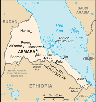 |
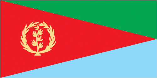
| The national flag of Eritrea | Borderline map of Eritrea |
| Flag description: red isosceles triangle (based on the hoist side) dividing the flag into two right triangles; the upper triangle is green, the lower one is blue; a gold wreath encircling a gold olive branch is centered on the hoist side of the red triangle; green stands for the country’s agriculture economy, red signifies the bloodshed in the fight for freedom, and blue symbolizes the bounty of the sea; the wreath-olive branch symbol is similar to that on the first flag of Eritrea from 1952; the shape of the red triangle broadly mimics the shape of the country. Note: one of several flags where a prominent component of the design reflects the shape of the country; other such flags are those of Bosnia and Herzegovina, Brazil, and Vanuatu. | Border length: total: 1,840 km. Border countries (total: 3): Djibouti 125 km, Ethiopia 1,033 km, Sudan 682 km. |
Did you know about Eritrea?
- Eritrea federated to Ethiopia in 1952 and fully integrated in 1962. From 1972, a long war of secession led to independence in 1993.
- Eritrea is the only country to secede successfully in postcolonial Africa.
- Asmara, Eritreas capital, boasts many fine Italian-style modern buildings, built when it was an Italian colony during the 20th century.
Facts of Eritrea (ER)
Name conventional long form: State of Eritrea, conventional short form: Eritrea, local long form: Hagere Ertra, local short form: Ertra, former: Eritrea Autonomous Region in Ethiopia, etymology: the country name derives from the ancient Greek appellation “Erythra Thalassa” meaning Red Sea, which is the major water body bordering the country
Codes: ISO; ER, Internet; .er
Capital city: Asmara
Language(s): Tigrinya (official language), Arabic (official language), English (official language), Tigre, Kunama, Afar, other Cushitic languages
National holiday(s): Independence Day, 24 May (1991)
Motto: N/A
Currency: Eritrean nakfa (ERN), since 1997
GPS: 15 00 N, 39 00 E, Asmara; 15 20 N 38 56 E
Location: Eastern Africa, bordering the Red Sea, between Djibouti and Sudan
Geography note: strategic geopolitical position along world’s busiest shipping lanes; Eritrea retained the entire coastline of Ethiopia along the Red Sea upon de jure independence from Ethiopia on 24 May 1993
Land boundaries: Djibouti 125 km, Ethiopia 1,033 km, Sudan 682 km, total: 1,840 km
Maritime boundaries: Red Sea
Coastline: 2,234 km (mainland on Red Sea 1,151 km, islands in Red Sea 1,083 km)
Area: total: 117,600 sq km; land: 101,000 sq km, water: 16,600 sq km (total 45 405,60 mi2), slightly larger than Pennsylvania.
Roadways: total: 4,010 km, paved: 874 km, unpaved: 3,136 km (2000)
Waterways: N/A
Local time (capital): UTC+3, 8 hours ahead of Washington DC during Standard Time
Note to the local time: N/A
Population in Eritrea: 5 187 948
Population in Asmara: 899 000 (including the metropolitan areas)
Urbanization: urban population: 22.6% of total population (2015)
Major urban areas population: ASMARA (capital) 804,000 (2015)
Population growth rate: 0.81% (2016 estimate)
Birth rate: 30.1 births / 1,000 population (2016 estimate)
Death rate: 7.3 deaths / 1,000 population (2016 estimate)
Age structure: 0-14 years: 40.66% (male 1,199,355 / female 1,187,467) 15-24 years: 19.39% (male 566,199 / female 571,743) 25-54 years: 32.33% (male 933,825 / female 963,812) 55-64 years: 3.73% (male 93,325 / female 125,411) 65 years and over: 3.9% (male 97,248 / female 131,484) (2016 estimate)
Median age: total: 19.4 years; male: 19 years, female: 19.9 years (2016 estimate)
Ethnic groups: nine recognized ethnic groups: Tigrinya 55%, Tigre 30%, Saho 4%, Kunama 2%, Rashaida 2%, Bilen 2%, other (Afar, Beni Amir, Nera) 5% (2010 estimate)
Religions: Muslim, Coptic Christian, Roman Catholic, Protestant
Government type: Unitary one-party presidential republic
Legal system: mixed legal system of civil, customary, and Islamic religious law
National anthem: Ertra, Ertra, Ertra
Known national hazards: frequent droughts, rare earthquakes and volcanoes; locust swarmsvolcanism: Dubbi (elev. 1,625 m), which last erupted in 1861, was the country’s only historically active volcano until Nabro (2,218 m) came to life on 12 June 2011
Major infectious diseases: The degree of risk(s): high food or waterborne diseases: bacterial diarrhea, hepatitis A, and typhoid fever vectorborne diseases: malaria and dengue fever (2016)
Land use: agricultural land: 75.1%; arable land 6.8%; permanent crops 0%; permanent pasture 68.3%; forest: 15.1%; other: 9.8% (2011 estimate)
Agricultural products: sorghum, lentils, vegetables, corn, cotton, tobacco, sisal; livestock, goats; fish
Industries: food processing, beverages, clothing and textiles, light manufacturing, salt, cement
Export commodities: gold and other minerals, livestock, sorghum, textiles, food, small industry manufactures
Main export partners: N/A
Import commodities: machinery, petroleum products, food, manufactured goods
Main import partners: N/A
Navigate the countries in Africa faster and easier while driving, use the interactive Google maps for your driving directions. The continuously updated database contains over 220 countries and territories digitally mapped, hundreds of millions of businesses and places around the world positioned on the map.
Get fresh GPS navigation, traffic, and transit information – no matter what part of Eritrea, Asmara, any other city and country in Africa, or the world you’re in.
Do you like this Eritrea information page? Please don’t forget to share it with others! Thank you.