Vanuatu Google maps and Driving Directions
Get free driving directions, Google maps, traffic information for Vanuatu, and Port Vila (GPS: 17 44 S 168 19 E), the capital city of the country located in (the) Oceania, group of islands in the South Pacific Ocean, about three-quarters of the way from Hawaii to Australia.
Find any address in Port Vila on the Google map of Vanuatu (VU) with ease or calculate your up to date itinerary to and from Vanuatu or its neighboring counties like N/A.
Sightseeing and exploring in Oceania starts here, thanks to Google because its Earth Engine combines a multi-petabyte catalog of updated satellite imagery and geospatial datasets with planetary-scale analysis capabilities. Wonder the world, use the satellite map function of the Google maps to explore or see differences on the Earth’s surface, inland, or the surrounding areas of Vanuatu.
Google Maps Vanuatu
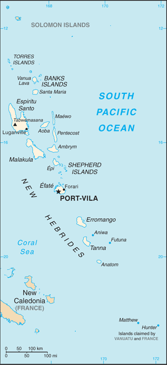
An archipelago of 82 islands and islets in the South Pacific, Vanuatu was ruled jointly by the UK and France from 1906 until independence in 1980. Politics is democratic but volatile.
Vanuatu is mostly mountainous islands of volcanic origin; narrow coastal plains.
The map above fully covers Vanuatu with its road routes from cities to towns, road intersections in any region, provinces, prefectures, also with free driving directions in Port Vila or to the neighboring towns and countries. To look at the detailed map about a particular quarter in Port-Vil, please click on the area and zoom to the place you are interested in the Google maps of Vanuatu (VU).
Be creative, use the extras of this Google map; This is a detailed, clear, zoomable, large road map of Vanuatu with its administrative divisions; 6 provinces; Malampa, Penama, Sanma, Shefa, Tafea, Torba.
The interactive map above is also may be used as the satellite map of Vanuatu, or as a reverse search map for finding an address from its GPS coordinates.
Vanuatu is an archipelago of 83 islands lying between New Caledonia and Fiji in the South Pacific. Largest of the islands is Espiritu Santo (875 sq mi 2,266 sq km) others are Efate, Malekula, Malo, Pentecost, and Tanna.
Vanuatu (area: 12 189 sq km / 4 706,20 sq mi), where the official language is Bislama, English, French, lying in Oceania and using the currency; Vanuatu vatu (VUV), since 1982, set their clock to UTC+11. That means they are 16 hours ahead of Washington DC during Standard Time in Port-Vil, the capital. Note to the time difference: N/A.
The climate in Vanuatu; Tropical. Temperatures and rainfall decline from north to south.
Geography in a nutshell; Mountainous and volcanic, with coral beaches and dense rainforest. Cultivated land along the coasts.
Click here for more detailed information about Vanuatu.
Driving directions Vanuatu
The Google maps and Google Satellite maps of Vanuatu above showing the country, located next to N/A. For your further reference, the latitude and longitude coordinates of Vanuatu are 16 00 S, 167 00 E , while the capital, Port-Vil found at 17 44 S 168 19 E.
When you are traveling around Vanuatu, Port-Vil, or its other cities, use this routing tool, providing up to date route planning service free of charge.
Look no further; get accurate driving directions in Vanuatu, Oceania, by filling the route planner form below.
[xyz-ihs snippet=”routing”]
Since Google acquired and introduced its digitalized maps in 2004, you’re probably familiar with its base functions, like finding an address or driving directions to locations. Still, Google maps also accommodate bicyclists, pedestrians, and also public transportation with special directions and customizable routes.
About Vanuatu and the capital, Port Vila
 |
 |
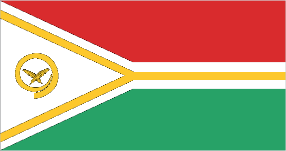
| The national flag of Vanuatu | Borderline map of Vanuatu |
| Flag description: two equal horizontal bands of red (top) and green with a black isosceles triangle (based on the hoist side) all separated by a black-edged yellow stripe in the shape of a horizontal Y (the two points of the Y face the hoist side and enclose the triangle); centered in the triangle is a boar’s tusk encircling two crossed namele fern fronds, all in yellow; red represents the blood of boars and men, as well as unity, green the richness of the islands, and black the ni-Vanuatu people; the yellow Y-shape – which reflects the pattern of the islands in the Pacific Ocean – symbolizes the light of the Gospel spreading through the islands; the boar’s tusk is a symbol of prosperity frequently worn as a pendant on the islands; the fern fronds represent peace. Note: one of several flags where a prominent component of the design reflects the shape of the country; other such flags are those of Bosnia and Herzegovina, Brazil, and Eritrea. | Border length: 0 km. |
Did you know about Vanuatu?
- Vanuatu, formerly known as the New Hebrides, was jointly administered by Britain and France from 1906. In 1980, it gained its independence.
- With 105 indigenous tongues, Vanuatu has the worlds highest per capita density of languages.
- Once known as the New Hebrides until its independence in 1980, Vanuatu today relies on its exports of cocoa and coconut products.
Facts of Vanuatu (VU)
Name conventional long form: Republic of Vanuatu, conventional short form: Vanuatu, local long form: Ripablik blong Vanuatu, local short form: Vanuatu, former: New Hebrides, etymology: derived from the words “vanua” (home or land) and “tu” (stand) that occur in several of the Austonesian languages spoken on the islands and which provide the meaning of “independence” or the sense of “our land”
Codes: ISO; VU, Internet; .vu
Capital city: Port Vila
Language(s): local languages (more than 100) 63.2%, Bislama (official language; creole) 33.7%, English (official language) 2%, French (official language) 0.6%, other 0.5% (2009 estimate)
National holiday(s): Independence Day, 30 July (1980)
Motto: Long God yumi stanap (In God we stand)
Currency: Vanuatu vatu (VUV), since 1982
GPS: 16 00 S, 167 00 E, Port Vila; 17 44 S 168 19 E
Location: Oceania, group of islands in the South Pacific Ocean, about three-quarters of the way from Hawaii to Australia
Geography note: a Y-shaped chain of four main islands and 80 smaller islands; several of the islands have active volcanoes and there are several underwater volcanoes as well
Land boundaries: N/A, 0 km
Maritime boundaries: Pacific Ocean
Coastline: 2,528 km
Area: total: 12,189 sq km; land: 12,189 sq km, water: 0 sq km (total 4 706,20 mi2), slightly larger than Connecticut.
Roadways: total: 1,070 km, paved: 256 km, unpaved: 814 km (2000)
Waterways: N/A
Local time (capital): UTC+11, 16 hours ahead of Washington DC during Standard Time
Note to the local time: N/A
Population in Vanuatu: 282 117
Population in Port-Vil: 47 000 (including the metropolitan areas)
Urbanization: urban population: 26.1% of total population (2015)
Major urban areas population: PORT-VILA (capital) 53,000 (2014)
Population growth rate: 1.9% (2016 estimate)
Birth rate: 24.5 births / 1,000 population (2016 estimate)
Death rate: 4.1 deaths / 1,000 population (2016 estimate)
Age structure: 0-14 years: 36.11% (male 51,160 / female 49,073) 15-24 years: 20% (male 27,559 / female 27,939) 25-54 years: 34.74% (male 47,189 / female 49,244) 55-64 years: 5.27% (male 7,327 / female 7,297) 65 years and over: 3.88% (male 5,470 / female 5,296) (2016 estimate)
Median age: total: 21.7 years; male: 21.3 years, female: 22.1 years (2016 estimate)
Ethnic groups: Ni-Vanuatu 97.6%, part Ni-Vanuatu 1.1%, other 1.3% (2009 estimate)
Religions: Protestant 70% (includes Presbyterian 27.9%, Anglican 15.1%, Seventh Day Adventist 12.5%, Assemblies of God 4.7%, Church of Christ 4.5%, Neil Thomas Ministry 3.1%, and Apostolic 2.2%), Roman Catholic 12.4%, customary beliefs 3.7% (including Jon Frum cargo cult), other 12.6%, none 1.1%, unspecified 0.2% (2009 estimate)
Government type: Unitary parliamentary republic
Legal system: mixed legal system of English common law, French law, and customary law
National anthem: Yumi, Yumi, Yumi (We, We, We)
Known national hazards: tropical cyclones or typhoons (January to April); volcanic eruption on Aoba (Ambae) island began on 27 November 2005, volcanism also causes minor earthquakes; tsunamisvolcanism: significant volcanic activity with multiple eruptions in recent years; Yasur (elev. 361 m), one of the world’s most active volcanoes, has experienced continuous activity in recent centuries; other historically active volcanoes include, Aoba, Ambrym, Epi, Gaua, Kuwae, Lopevi, Suretamatai, and Traitor’s Head
Major infectious diseases: N/A
Land use: agricultural land: 15.3%; arable land 1.6%; permanent crops 10.3%; permanent pasture 3.4%; forest: 36.1%; other: 48.6% (2011 estimate)
Agricultural products: copra, coconuts, cocoa, coffee, taro, yams, fruits, vegetables; beef; fish
Industries: food and fish freezing, wood processing, meat canning
Export commodities: copra, beef, cocoa, timber, kava, coffee
Main export partners: Japan 35.1%, Turkey 10.5%, Thailand 8.7%, China 8.2%, Venezuela 5.9%, UK 5.6% (2015)
Import commodities: machinery and equipment, foodstuffs, fuels
Main import partners: China 16.7%, Australia 14.6%, Japan 13.9%, Singapore 10%, Fiji 9.3%, NZ 8.3%, New Caledonia 5.2% (2015)
Navigate the countries in Oceania faster and easier while driving, use the interactive Google maps for your driving directions. The continuously updated database contains over 220 countries and territories digitally mapped, hundreds of millions of businesses and places around the world positioned on the map.
Get fresh GPS navigation, traffic, and transit information – no matter what part of Vanuatu, Port Vila, any other city and country in Oceania, or the world you’re in.
Do you like this Vanuatu information page? Please don’t forget to share it with others! Thank you.
14 thoughts on “Vanuatu”
Comments are closed.