Bhutan Google maps and Driving Directions
Get free driving directions, Google maps, traffic information for Bhutan, and Thimphu (GPS: 27 28 N 89 38 E), the capital city of the country located in (the) Southern Asia, between China and India.
Find any address in Thimphu on the Google map of Bhutan (BT) with ease or calculate your up to date itinerary to and from Bhutan or its neighboring counties like China, India.
Sightseeing and exploring in Asia starts here, thanks to Google because its Earth Engine combines a multi-petabyte catalog of updated satellite imagery and geospatial datasets with planetary-scale analysis capabilities. Wonder the world, use the satellite map function of the Google maps to explore or see differences on the Earth’s surface, inland, or the surrounding areas of Bhutan.
Google Maps Bhutan
Perched in the eastern Himalayas between India and China lies the landlocked Kingdom of Bhutan. It is largely closed to the outside world to protect its culture; TV banned until 1999.
Bhutan is mostly mountainous with some fertile valleys and savanna.
The map above fully covers Bhutan with its road routes from cities to towns, road intersections in any region, provinces, prefectures, also with free driving directions in Thimphu or to the neighboring towns and countries. To look at the detailed map about a particular quarter in Thimphu, please click on the area and zoom to the place you are interested in the Google maps of Bhutan (BT).
Be creative, use the extras of this Google map; This is a detailed, clear, zoomable, large road map of Bhutan with its administrative divisions; 20 districts (dzongkhag, singular and plural); Bumthang, Chhukha, Chirang, Daga, Gasa, Geylegphug, Ha, Lhuntshi, Mongar, Paro, Pemagatsel, Punakha, Samchi, Samdrup Jongkhar, Shemgang, Tashigang, Tashi Yangtse, Thimphu, Tongsa, Wangdi Phodrang.
The interactive map above is also may be used as the satellite map of Bhutan, or as a reverse search map for finding an address from its GPS coordinates.
Mountainous Bhutan, half the size of Indiana, is situated on the southeast slope of the Himalayas, bordered on the north and east by Tibet and on the south and west and east by India. The landscape consists of a succession of lofty and rugged mountains and deep valleys. In the north, towering peaks reach a height of 24,000 ft (7,315 m).
Bhutan (area: 38 394 sq km / 14 824,00 sq mi), where the official language is Dzongkha, lying in Asia and using the currency; Bhutanese ngultrum (BTN), since 1974, set their clock to UTC+6. That means they are 11 hours ahead of Washington DC during Standard Time in Thimphu, the capital. Note to the time difference: N/A.
The climate in Bhutan; South is tropical, north is alpine, cold, and harsh. Central valleys are warmer in east than west.
Geography in a nutshell; Low, tropical southern strip rising through fertile central valleys to high the Himalayas in the north. Around 70% of the land is forested.
Click here for more detailed information about Bhutan.
Driving directions Bhutan
The Google maps and Google Satellite maps of Bhutan above showing the country, located next to China, India. For your further reference, the latitude and longitude coordinates of Bhutan are 27 30 N, 90 30 E , while the capital, Thimphu found at 27 28 N 89 38 E.
When you are traveling around Bhutan, Thimphu, or its other cities, use this routing tool, providing up to date route planning service free of charge.
Look no further; get accurate driving directions in Bhutan, Asia, by filling the route planner form below.
Since Google acquired and introduced its digitalized maps in 2004, you’re probably familiar with its base functions, like finding an address or driving directions to locations. Still, Google maps also accommodate bicyclists, pedestrians, and also public transportation with special directions and customizable routes.
About Bhutan and the capital, Thimphu
 |
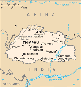 |
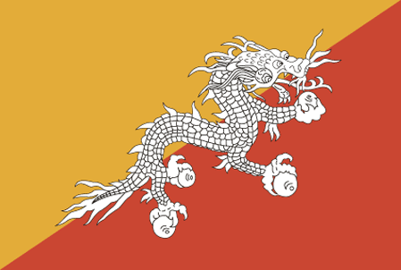
| The national flag of Bhutan | Borderline map of Bhutan |
| Flag description: divided diagonally from the lower hoist-side corner; the upper triangle is yellow, and the lower triangle is orange; centered along the dividing line is a large black and white dragon facing away from the hoist side; the dragon, called the Druk (Thunder Dragon), is the emblem of the nation; its white color stands for purity and the jewels in its claws symbolize wealth; the background colors represent spiritual and secular powers within Bhutan: the orange is associated with Buddhism, while the yellow denotes the ruling dynasty. | Border length: total: 1,136 km. Border countries (total: 2): China 477 km, India 659 km. |
Did you know about Bhutan?
- Bhutan is a Buddhist state where power is shared by the king and government. The countrys name in the local dialect means “Land of the Dragon.”
- In 2004 Bhutan became the first country in the world to ban smoking and the sale of tobacco.
- Bhutan is notable for pioneering the concept of gross national happiness.
Facts of Bhutan (BT)
Name conventional long form: Kingdom of Bhutan, conventional short form: Bhutan, local long form: Druk Gyalkhap, local short form: Druk Yul, etymology: named after the Bhotia, the ethnic Tibetans who migrated from Tibet to Bhutan; Bod is the Tibetan name for their land; the Bhutanese name “Druk Yul” means “Land of the Thunder Dragon”
Codes: ISO; BT, Internet; .bt
Capital city: Thimphu
Language(s): Sharchhopka 28%, Dzongkha (official language) 24%, Lhotshamkha 22%, other 26% (includes foreign languages) (2005 estimate)
National holiday(s): National Day (Ugyen WANGCHUCK became first hereditary king), 17 December (1907)
Motto: N/A
Currency: Bhutanese ngultrum (BTN), since 1974
GPS: 27 30 N, 90 30 E, Thimphu; 27 28 N 89 38 E
Location: Southern Asia, between China and India
Geography note: landlocked country; strategic location between China and India; controls several key Himalayan mountain passes
Land boundaries: China 477 km, India 659 km, total: 1,136 km
Maritime boundaries: N/A
Coastline: 0 km (landlocked country)
Area: total: 38,394 sq km; land: 38,394 sq km, water: 0 sq km (total 14 824,00 mi2), about one-half the size of Indiana.
Roadways: total: 10,578 km, paved: 2,975 km (includes 2,180 km of natonal highways), unpaved: 7,603 km (2013)
Waterways: N/A
Local time (capital): UTC+6, 11 hours ahead of Washington DC during Standard Time
Note to the local time: N/A
Population in Bhutan: 817 054
Population in Thimphu: 60 200 (including the metropolitan areas)
Urbanization: urban population: 38.6% of total population (2015)
Major urban areas population: THIMPHU (capital) 152,000 (2014)
Population growth rate: 1.09% (2016 estimate)
Birth rate: 17.5 births / 1,000 population (2016 estimate)
Death rate: 6.6 deaths / 1,000 population (2016 estimate)
Age structure: 0-14 years: 26.27% (male 100,672 / female 96,368) 15-24 years: 19.21% (male 73,398 / female 70,704) 25-54 years: 42.39% (male 169,079 / female 148,873) 55-64 years: 5.94% (male 23,869 / female 20,656) 65 years and over: 6.2% (male 24,301 / female 22,205) (2016 estimate)
Median age: total: 27.2 years; male: 27.7 years, female: 26.6 years (2016 estimate)
Ethnic groups: Ngalop (also known as Bhote) 50%, ethnic Nepalese 35% (includes Lhotsampas – one of several Nepalese ethnic groups), indigenous or migrant tribes 15%
Religions: Lamaistic Buddhist 75.3%, Indian- and Nepalese-influenced Hinduism 22.1%, other 2.6% (2005 estimate)
Government type: Unitary parliamentary constitutional monarchy
Legal system: civil law based on Buddhist religious law
National anthem: Druk tsendhen (The Thunder Dragon Kingdom)
Known national hazards: violent storms from the Himalayas are the source of the country’s Bhutanese name, which translates as Land of the Thunder Dragon; frequent landslides during the rainy season
Major infectious diseases: The degree of risk(s): high food or waterborne diseases: bacterial and protozoal diarrhea, hepatitis A, and typhoid fever vectorborne diseases: dengue fever (2016)
Land use: agricultural land: 13.6%; arable land 2.6%; permanent crops 0.3%; permanent pasture 10.7%; forest: 85.5%; other: 0.9% (2011 estimate)
Agricultural products: rice, corn, root crops, citrus; dairy products, eggs
Industries: cement, wood products, processed fruits, alcoholic beverages, calcium carbide, tourism
Export commodities: electricity (to India), ferrosilicon, cement, calcium carbide, copper wire, manganese, vegetable oil
Main export partners: India 83.8%, Hong Kong 10.8% (2013 estimate)
Import commodities: fuel and lubricants, passenger cars, machinery and parts, fabrics, rice
Main import partners: India 72.3%, South Korea 6% (2013 estimate)
Navigate the countries in Asia faster and easier while driving, use the interactive Google maps for your driving directions. The continuously updated database contains over 220 countries and territories digitally mapped, hundreds of millions of businesses and places around the world positioned on the map.
Get fresh GPS navigation, traffic, and transit information – no matter what part of Bhutan, Thimphu, any other city and country in Asia, or the world you’re in.
Do you like this Bhutan information page? Please don’t forget to share it with others! Thank you.