Portugal Google maps and Driving Directions
Get free driving directions, Google maps, traffic information for Portugal, and Lisbon (GPS: 38 43 N 9 08 W), the capital city of the country located in (the) Southwestern Europe, bordering the North Atlantic Ocean, west of Spain.
Find any address in Lisbon on the Google map of Portugal (PT) with ease or calculate your up to date itinerary to and from Portugal or its neighboring counties like Spain.
Sightseeing and exploring in Europe starts here, thanks to Google because its Earth Engine combines a multi-petabyte catalog of updated satellite imagery and geospatial datasets with planetary-scale analysis capabilities. Wonder the world, use the satellite map function of the Google maps to explore or see differences on the Earth’s surface, inland, or the surrounding areas of Portugal.
Google Maps Portugal
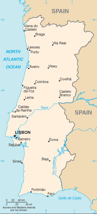
Portugal, with its long Atlantic coast, lies on the western side of the Iberian Peninsula, which it shares with Spain. It is the most westerly country on the European mainland.
Portugal is the west-flowing Tagus River divides the country: the north is mountainous toward the interior, while the south is characterized by rolling plains.
The map above fully covers Portugal with its road routes from cities to towns, road intersections in any region, provinces, prefectures, also with free driving directions in Lisbon or to the neighboring towns and countries. To look at the detailed map about a particular quarter in Lisbon, please click on the area and zoom to the place you are interested in the Google maps of Portugal (PT).
Be creative, use the extras of this Google map; This is a detailed, clear, zoomable, large road map of Portugal with its administrative divisions; 18 districts (distritos, singular – distrito) and 2 autonomous regions* (regioes autonomas, singular – regiao autonoma); Aveiro, Acores (Azores)*, Beja, Braga, Braganca, Castelo Branco, Coimbra, Evora, Faro, Guarda, Leiria, Lisboa (Lisbon), Madeira*, Portalegre, Porto, Santarem, Setubal, Viana do Castelo, Vila Real, Viseu.
The interactive map above is also may be used as the satellite map of Portugal, or as a reverse search map for finding an address from its GPS coordinates.
Portugal occupies the western part of the Iberian Peninsula and is slightly smaller than Indiana. The country is crossed by three large rivers that rise in Spain, flow into the Atlantic, and divide the country into three geographic areas. The Minho River, part of the northern boundary, cuts through a mountainous area that extends south to the vicinity of the Douro River. South of the Douro, the mountains slope to the plains around the Tejo River. The remaining division is the southern one of Alentejo. The Azores stretch over 340 mi (547 km) in the Atlantic and consist of nine islands with a total area of 902 sq mi (2,335 sq km). Madeira, consisting of two inhabited islands, Madeira and Porto Santo, and two groups of uninhabited islands, lie in the Atlantic about 535 mi (861 km) southwest of Lisbon.
Portugal (area: 92 090 sq km / 35 556,13 sq mi), where the official language is Portuguese, lying in Europe and using the currency; Euro (EUR), since 1999, set their clock to UTC 0. That means they are 5 hours ahead of Washington DC during Standard Time in Lisbon, the capital. Note to the time difference: Daylight saving time: +1hr begins last Sunday in March; ends last Sunday in October.
The climate in Portugal; North is cool and moist. South is warmer, with dry, mild winters.
Geography in a nutshell; The Tagus River bisects the country roughly east to west, dividing mountainous north from lower and more undulating south.
Click here for more detailed information about Portugal.
Driving directions Portugal
The Google maps and Google Satellite maps of Portugal above showing the country, located next to Spain. For your further reference, the latitude and longitude coordinates of Portugal are 39 30 N, 8 00 W , while the capital, Lisbon found at 38 43 N 9 08 W.
When you are traveling around Portugal, Lisbon, or its other cities, use this routing tool, providing up to date route planning service free of charge.
Look no further; get accurate driving directions in Portugal, Europe, by filling the route planner form below.
Since Google acquired and introduced its digitalized maps in 2004, you’re probably familiar with its base functions, like finding an address or driving directions to locations. Still, Google maps also accommodate bicyclists, pedestrians, and also public transportation with special directions and customizable routes.
About Portugal and the capital, Lisbon
 |
 |
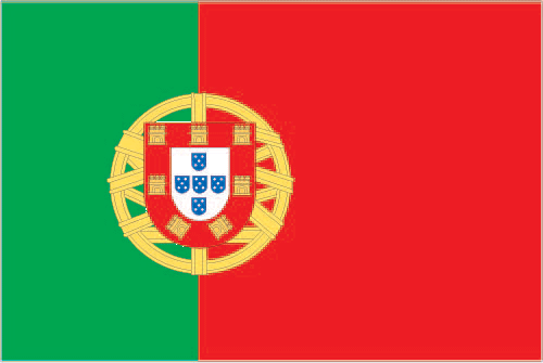
| The national flag of Portugal | Borderline map of Portugal |
| Flag description: two vertical bands of green (hoist side, two-fifths) and red (three-fifths) with the national coat of arms (armillary sphere and Portuguese shield) centered on the dividing line; explanations for the color meanings are ambiguous, but a popular interpretation has green symbolizing hope and red the blood of those defending the nation. | Border length: total: 1,224 km. Border countries (total: 1): Spain 1,224 km. |
About Lisbon
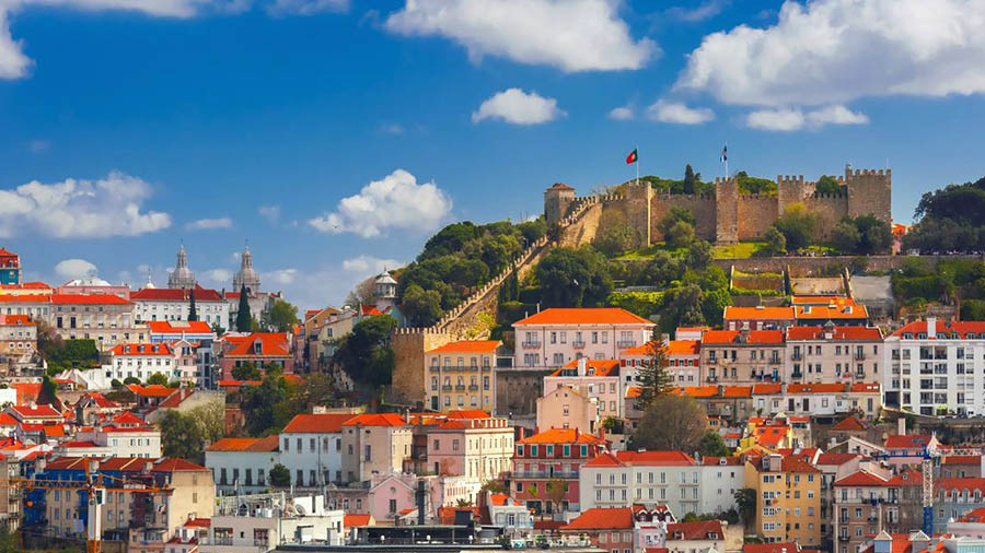
Lisbon, Europe’s smallest capital, has blossomed into a cosmopolitan city. Sections of Avenida da Liberdade, the main street, evoke thoughts of Paris. Some of the formerly clogged streets of the downtown Baixa district have been closed to traffic, and cobblestone pedestrian malls created. Sidewalk portrait painters offer to sketch your likeness, and vendors peddle jewelry and handcrafts ranging from embroidery to leatherwork. In the colder months, smoke billows from charcoal braziers roasting chestnuts.
The world dropped in on this city of seven hills as it celebrated EXPO ’98, marking the 500th anniversary of Vasco da Gama’s journey to India. Although Portugal has since stubbed its toe on its way to greater prosperity, many of its attractions and facilities were left behind after the exhibition, including the Oceanarium, the largest aquarium in Europe; indoor stadiums; convention centers; and a marina that can moor between 700 and 900 leisure craft.
Some 1.6 million people now call Lisbon home, and many of its citizens, having drifted in from the far corners of the world, don’t even speak Portuguese. Consider an off-season visit, when the city is at its most glorious, before or after the hot and humid days of July and August. The town isn’t overrun with visitors during spring and fall, and prices for lodgings are significantly lower than in summer.
Did you know about Portugal?
- During the 15th and 16th centuries, Portugal played a leading role in discovering the world beyond Europe. It formed a republic in 1910.
- Portugal is the worlds leading producer of cork, which comes from the bark of the cork oak.
- Produced from grapes grown in the north of the country and stored in casks, or “pipes, made from the local oak trees before bottling, port is Portugals most famous export.
Portugal, to the west of Spain, includes the island groups of Madeira and the Azores in the Atlantic. Mainland Portugal has a long Atlantic coastline and is mountainous only in the north. To the south, lie the extensive plains of the Alentejo region, which are broken by a range of hills that divide them from the coastal plain of the Algarve. The Iberian Peninsula is traversed by several large rivers that rise in Spain and flow on across Portugal, often through deep gorges cut through the rocks of the mountains, such as the Tejo (Tajo in Spain) with the capital city of Lisbon (Lisboa) at its mouth.
As agricultural methods remain traditional in many areas, wild animals and birds can flourish relatively undisturbed. Manufacturing has assumed greater importance as the country slowly moves away from a largely agriculture-based economy, but about 25 percent of people are still engaged in farming and live outside the main cities in small rural villages. About 40 percent of Portugal is wooded, and the country is a leading exporter of cork. It also manufactures other wood products and paper. The country’s long coastline has meant that Portuguese fishers have always enjoyed ready access to the Atlantic fishing grounds.
Portugal has some valuable mineral resources, and these include copper ores, wolframite, coal, kaolin, gold, tin and iron ore. A petrochemical plant and oil refinery located near Lisbon, and hydroelectric power developed in recent years. Portugal is also renowned for certain high-quality craft products, especially lace, pottery and tiles and for its port wine, named after the city of Porto (Oporto).
Lisbon
Lisbon, the capital city of Portugal, is situated in the west of the country and is built on seven hills around the estuary of the River Tejo. The seafaring Phoenicians were the first people to build a settlement on the site, which they called Alis Ubbo (Serene Harbour). The name Lisbon later derived from the old Phoenician name.
Buildings of note include, first and foremost, the castle of Sao Jorge, which reflects many centuries of human occupation – Roman, Visigoth, Moor, and Portuguese. The ruined palace inside its massive outer walls was built in the 13th century and was the home of the Portuguese kings for three centuries. Later, when a new royal palace built at another site in the city, the castle of Sao Jorge served as a prison.
The white limestone monastery of Jeronimos was built by Emanuel to honor and express gratitude to his patron saint for the discovery of the ocean route to India and the establishment of the spice trade. The interior noted for its fine sculptures and stone carvings, which include figures of St Jerónimos and the Virgin and Child, animals, birds, vegetables and fruits.
The pink rococo-style Palace of Queluz was built during the 18th century and heavily influenced by Versailles. It is lavishly furnished and decorated in the elegant and extravagant style of the period and has fine formal gardens containing statues and fountains. Today, the palace is used to house and entertain visiting foreign dignitaries and for banquets and formal state occasions, as well as being a considerable tourist attraction.
Facts of Portugal (PT)
Name conventional long form: Portuguese Republic, conventional short form: Portugal, local long form: Republica Portuguesa, local short form: Portugal, etymology: name derives from the Roman designation “Portus Cale” meaning “Port of Cale”; Cale was an ancient Celtic town and port in present-day northern Portugal
Codes: ISO; PT, Internet; .pt
Capital city: Lisbon
Language(s): Portuguese (official language), Mirandese (official language, but locally used)
National holiday(s): Portugal Day (Dia de Portugal), 10 June (1580)
Motto: N/A
Currency: Euro (EUR), since 1999
GPS: 39 30 N, 8 00 W, Lisbon; 38 43 N 9 08 W
Location: Southwestern Europe, bordering the North Atlantic Ocean, west of Spain
Geography note: Azores and Madeira Islands occupy strategic locations along western sea approaches to Strait of Gibraltar
Land boundaries: Spain 1,224 km, total: 1,224 km
Maritime boundaries: Atlantic Ocean
Coastline: 1,793 km
Area: total: 92,090 sq km; land: 91,470 sq km, water: 620 sq km (total 35 556,13 mi2), slightly smaller than Indiana.
Roadways: total: 82,900 km, paved: 71,294 km (includes 2,613 km of expressways), unpaved: 11,606 km (2008)
Waterways: 210 km (on Douro River from Porto) (2011)
Local time (capital): UTC 0, 5 hours ahead of Washington DC during Standard Time
Note to the local time: Daylight saving time: +1hr begins last Sunday in March; ends last Sunday in October
Population in Portugal: 10 291 196
Population in Lisbon: 2 843 000 (including the metropolitan areas)
Urbanization: urban population: 63.5% of total population (2015)
Major urban areas population: LISBON (capital) 2.884 million; Porto 1.299 million (2015)
Population growth rate: 0.07% (2016 estimate)
Birth rate: 9.1 births / 1,000 population (2016 estimate)
Death rate: 11.1 deaths / 1,000 population (2016 estimate)
Age structure: 0-14 years: 15.5% (male 874,807 / female 804,483) 15-24 years: 11.4% (male 655,234 / female 579,669) 25-54 years: 41.88% (male 2,300,872 / female 2,236,077) 55-64 years: 12.07% (male 610,886 / female 697,287) 65 years and over: 19.15% (male 849,506 / female 1,224,995) (2016 estimate)
Median age: total: 41.8 years; male: 39.8 years, female: 44 years (2016 estimate)
Ethnic groups: homogeneous Mediterranean stock; citizens of black African descent who immigrated to mainland during decolonization number less than 100,000; since 1990 East Europeans have entered Portugal
Religions: Roman Catholic 81%, other Christian 3.3%, other (includes Jewish, Muslim, other) 0.6%, none 6.8%, unspecified 8.3%note: represents population 15 years of age and older (2011 estimate)
Government type: Unitary semi-presidential constitutional republic
Legal system: civil law system; Constitutional Court review of legislative acts
National anthem: A Portuguesa (The Portuguese)
Known national hazards: Azores subject to severe earthquakesvolcanism: limited volcanic activity in the Azores Islands; Fayal or Faial (elev. 1,043 m) last erupted in 1958; most volcanoes have not erupted in centuries; historically active volcanoes include Agua de Pau, Furnas, Pico, Picos Volcanic System, San Jorge, Sete Cidades, and Terceira
Major infectious diseases: N/A
Land use: agricultural land: 39.7%; arable land 11.9%; permanent crops 7.8%; permanent pasture 20%; forest: 37.8%; other: 22.5% (2011 estimate)
Agricultural products: grain, potatoes, tomatoes, olives, grapes; sheep, cattle, goats, pigs, poultry, dairy products; fish
Industries: textiles, clothing, footwear, wood and cork, paper and pulp, chemicals, lubricants, automobiles and auto parts, base metals, minerals, porcelain and ceramics, glassware, technology, telecommunications; dairy products, wine, other foodstuffs; ship construc
Export commodities: agricultural products, foodstuffs, wine, oil products, chemical products, plastics and rubber, hides, leather, wood and cork, wood pulp and paper, textile materials, clothing, footwear, machinery and tools, base metals
Main export partners: Spain 25%, France 12.1%, Germany 11.8%, UK 6.7%, US 5.2%, Angola 4.2%, Netherlands 4% (2015)
Import commodities: agricultural products, chemical products, vehicles and other transport material, optical and precision instruments, computer accessories and parts, semiconductors and related devices, oil products, base metals, food products, textile materials
Main import partners: Spain 32.9%, Germany 12.9%, France 7.4%, Italy 5.4%, Netherlands 5.1% (2015)
Navigate the countries in Europe faster and easier while driving, use the interactive Google maps for your driving directions. The continuously updated database contains over 220 countries and territories digitally mapped, hundreds of millions of businesses and places around the world positioned on the map.
Get fresh GPS navigation, traffic, and transit information – no matter what part of Portugal, Lisbon, any other city and country in Europe, or the world you’re in.
Do you like this Portugal information page? Please don’t forget to share it with others! Thank you.