Korea South Google maps and Driving Directions
Get free driving directions, Google maps, traffic information for Korea South, and Seoul (GPS: 37 33 N 126 59 E), the capital city of the country located in (the) Eastern Asia, southern half of the Korean Peninsula bordering the Sea of Japan and the Yellow Sea.
Find any address in Seoul on the Google map of Korea South (KR) with ease or calculate your up to date itinerary to and from Korea South or its neighboring counties like North Korea.
Sightseeing and exploring in Asia starts here, thanks to Google because its Earth Engine combines a multi-petabyte catalog of updated satellite imagery and geospatial datasets with planetary-scale analysis capabilities. Wonder the world, use the satellite map function of the Google maps to explore or see differences on the Earth’s surface, inland, or the surrounding areas of Korea South.
Google Maps Korea South
South Korea occupies the southern half of the Korean peninsula. Under US sponsorship, it was separated from the communist North in 1948 and is now a capitalist economy.
Korea South is mostly hills and mountains; wide coastal plains in west and south.
The map above fully covers Korea South with its road routes from cities to towns, road intersections in any region, provinces, prefectures, also with free driving directions in Seoul or to the neighboring towns and countries. To look at the detailed map about a particular quarter in Seoul, please click on the area and zoom to the place you are interested in the Google maps of Korea South (KR).
Be creative, use the extras of this Google map; This is a detailed, clear, zoomable, large road map of Korea South with its administrative divisions; 9 provinces (do, singular and plural), 6 metropolitan cities (gwangyeoksi, singular and plural), 1 special city (teugbyeolsi), and 1 special self-governing city (teukbyeoljachisi)provinces: Chungbuk (North Chungcheong), Chungnam (South Chungcheong), Gangwon, Gyeongbuk (North Gyeongsang), Gyeonggi, Gyeongnam (South Gyeongsang), Jeju, Jeonbuk (North Jeolla), Jeonnam (South Jeolla)metropolitan cities: Busan (Pusan), Daegu (Taegu), Daejeon (Taejon), Gwangju (Kwangju), Incheon (Inch’on), Ulsanspecial city: Seoulspecial self-governing city: Sejong.
The interactive map above is also may be used as the satellite map of Korea South, or as a reverse search map for finding an address from its GPS coordinates.
Slightly larger than Indiana, South Korea lies below the 38th parallel on the Korean peninsula. It is mountainous in the east in the west and south are many harbors on the mainland and offshore islands.
South Korea (area: 100 363 sq km / 38 750,36 sq mi), where the official language is Korean, Korean Sign Language, lying in Asia and using the currency; Korean Republic won (KRW), set their clock to UTC+9. That means they are 14 hours ahead of Washington DC during Standard Time in Seoul, the capital. Note to the time difference: N/A.
The climate in Korea South; There are four distinct seasons. Winters are dry, and bitterly cold. Summers are hot and humid.
Geography in a nutshell; Over 80% is mountainous and two-thirds is forested. The flattest and most populous parts lie along the west coast and in the extreme south.
Click here for more detailed information about Korea South.
Driving directions Korea South
The Google maps and Google Satellite maps of Korea South above showing the country, located next to North Korea. For your further reference, the latitude and longitude coordinates of Korea South are 37 00 N, 127 30 E , while the capital, Seoul found at 37 33 N 126 59 E.
When you are traveling around Korea South, Seoul, or its other cities, use this routing tool, providing up to date route planning service free of charge.
Look no further; get accurate driving directions in Korea South, Asia, by filling the route planner form below.
Since Google acquired and introduced its digitalized maps in 2004, you’re probably familiar with its base functions, like finding an address or driving directions to locations. Still, Google maps also accommodate bicyclists, pedestrians, and also public transportation with special directions and customizable routes.
About Korea South and the capital, Seoul
 |
 |
| The national flag of Korea South | Borderline map of Korea South |
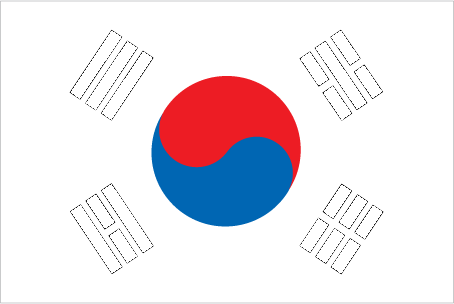
| Flag description: white with a red (top) and blue yin-yang symbol in the center; there is a different black trigram from the ancient I Ching (Book of Changes) in each corner of the white field; the South Korean national flag is called Taegukki; white is a traditional Korean color and represents peace and purity; the blue section represents the negative cosmic forces of the yin, while the red symbolizes the opposite positive forces of the yang; each trigram (kwae) denotes one of the four universal elements, which together express the principle of movement and harmony. | Border length: total: 237 km. Border countries (total: 1): North Korea 237 km. |
Did you know about Korea South?
- South Korea forms the southern half of the Korean Peninsula, which was partitioned close to the 38th parallel after World War II.
- Half of all Koreans are named Kim, Lee, Park, or Choi.
- One-third of the worlds new ships come from South Korean shipyards, which work at an impressive rate to complete a new ship once every four working days!
Facts of Korea South (KR)
Name conventional long form: Republic of Korea, conventional short form: South Korea, local long form: Taehan-min’guk, local short form: Han’gukabbreviation: ROK, etymology: derived from the Chinese name for Goryeo, which was the Korean dynasty that united the peninsula in the 10th century A.D.; the South Korean name “Han’guk” means “land of the Han,” where “han” may have its origins in the native root for “great [leader]” (similar to the title “khan”)
Codes: ISO; KR, Internet; .kr
Capital city: Seoul
Language(s): Korean, English (widely taught in junior high and high school)
National holiday(s): Liberation Day, 15 August (1945)
Motto: Benefit broadly in the human world
Currency: Korean Republic won (KRW)
GPS: 37 00 N, 127 30 E, Seoul; 37 33 N 126 59 E
Location: Eastern Asia, southern half of the Korean Peninsula bordering the Sea of Japan and the Yellow Sea
Geography note: strategic location on Korea Strait
Land boundaries: North Korea 237 km, total: 237 km
Maritime boundaries:
Coastline: 2,413 km
Area: total: 99,720 sq km; land: 96,920 sq km, water: 2,800 sq km (total 38 750,36 mi2), slightly smaller than Pennsylvania; slightly larger than Indiana.
Roadways: total: 104,983 km, paved: 83,199 km (includes 3,779 km of expressways), unpaved: 21,784 km (2009)
Waterways: 1,600 km (most navigable only by small craft) (2011)
Local time (capital): UTC+9, 14 hours ahead of Washington DC during Standard Time
Note to the local time: N/A
Population in Korea South: 51,446,201
Population in Seoul: 10 287 847 (including the metropolitan areas)
Urbanization: urban population: 82.5% of total population (2015)
Major urban areas population: SEOUL (capital) 9.774 million; Busan (Pusan) 3.216 million; Incheon (Inch’on) 2.685 million; Daegu (Taegu) 2.244 million; Daejon (Taejon) 1.564 million; Gwangju (Kwangju) 1.536 million (2015)
Population growth rate: 0.53% (2016 estimate)
Birth rate: 8.4 births / 1,000 population (2016 estimate)
Death rate: 5.8 deaths / 1,000 population (2016 estimate)
Age structure: 0-14 years: 13.45% (male 3,535,137 / female 3,315,510) 15-24 years: 13.08% (male 3,515,779 / female 3,146,084) 25-54 years: 45.93% (male 12,008,399 / female 11,379,261) 55-64 years: 14.01% (male 3,521,569 / female 3,611,481) 65 years and over: 13.53% (male 2,918,156 / female 3,972,796) (2016 estimate)
Median age: total: 41.2 years; male: 39.7 years, female: 42.8 years (2016 estimate)
Ethnic groups: homogeneous
Religions: Christian 31.6% (Protestant 24.0%, Catholic 7.6%), Buddhist 24.2%, other or unknown 0.9%, none 43.3% (2010 estimate)
Government type: Unitary presidential constitutional republic
Legal system: mixed legal system combining European civil law, Anglo-American law, and Chinese classical thought
National anthem: Aegukga
Known national hazards: occasional typhoons bring high winds and floods; low-level seismic activity common in southwestvolcanism: Halla (elev. 1,950 m) is considered historically active although it has not erupted in many centuries
Major infectious diseases: N/A
Land use: agricultural land: 18.1%; arable land 15.3%; permanent crops 2.2%; permanent pasture 0.6%; forest: 63.9%; other: 18% (2011 estimate)
Agricultural products: rice, root crops, barley, vegetables, fruit; cattle, pigs, chickens, milk, eggs; fish
Industries: electronics, telecommunications, automobile production, chemicals, shipbuilding, steel
Export commodities: semiconductors, petrochemicals, automobile/auto parts, ships, wireless communication equipment, flat display displays, steel, electronics, plastics, computers
Main export partners: China 26%, US 13.3%, Hong Kong 5.8%, Vietnam 5.3%, Japan 4.9% (2015)
Import commodities: crude oil/petroleum products, semiconductors, natural gas, coal, steel, computers, wireless communication equipment, automobiles, fine chemical, textiles
Main import partners: China 20.7%, Japan 10.5%, US 10.1%, Germany 4.8%, Saudi Arabia 4.5% (2015)
Navigate the countries in Asia faster and easier while driving, use the interactive Google maps for your driving directions. The continuously updated database contains over 220 countries and territories digitally mapped, hundreds of millions of businesses and places around the world positioned on the map.
Get fresh GPS navigation, traffic, and transit information – no matter what part of Korea South, Seoul, any other city and country in Asia, or the world you’re in.
Do you like this Korea South information page? Please don’t forget to share it with others! Thank you.