Paraguay Google maps and Driving Directions
Get free driving directions, Google maps, traffic information for Paraguay, and Asunción (GPS: 25 16 S 57 40 W), the capital city of the country located in (the) Central South America, northeast of Argentina, southwest of Brazil.
Find any address in Asunción on the Google map of Paraguay (PY) with ease or calculate your up to date itinerary to and from Paraguay or its neighboring counties like Argentina, Bolivia, Brazil.
Sightseeing and exploring in America starts here, thanks to Google because its Earth Engine combines a multi-petabyte catalog of updated satellite imagery and geospatial datasets with planetary-scale analysis capabilities. Wonder the world, use the satellite map function of the Google maps to explore or see differences on the Earth’s surface, inland, or the surrounding areas of Paraguay.
Google Maps Paraguay
Landlocked in central South America, and once a Spanish colony, Paraguays postindependence history has included periods of military rule. Free elections were held in 1993.
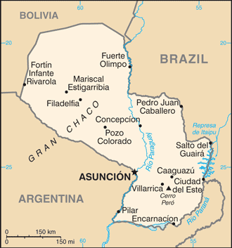
Paraguay is grassy plains and wooded hills east of Rio Paraguay; Gran Chaco region west of Rio Paraguay mostly low, marshy plain near the river, and dry forest and thorny scrub elsewhere.
The map above fully covers Paraguay with its road routes from cities to towns, road intersections in any region, provinces, prefectures, also with free driving directions in Asunción or to the neighboring towns and countries. To look at the detailed map about a particular quarter in Asuncion, please click on the area and zoom to the place you are interested in the Google maps of Paraguay (PY).
Be creative, use the extras of this Google map; This is a detailed, clear, zoomable, large road map of Paraguay with its administrative divisions; 17 departments (departamentos, singular – departamento) and 1 capital city*; Alto Paraguay, Alto Parana, Amambay, Asuncion*, Boqueron, Caaguazu, Caazapa, Canindeyu, Central, Concepcion, Cordillera, Guaira, Itapua, Misiones, Neembucu, Paraguari, Presidente Hayes, San Pedro.
The interactive map above is also may be used as the satellite map of Paraguay, or as a reverse search map for finding an address from its GPS coordinates.
California-size Paraguay is surrounded by Brazil, Bolivia, and Argentina in south-central South America. Eastern Paraguay, between the Paraná and Paraguay rivers, is upland country with the thickest population settled on the grassy slope that inclines toward the Paraguay River. The greater part of the Chaco region to the west is covered with marshes, lagoons, dense forests, and jungles.
Paraguay (area: 406 752 sq km / 157 047,76 sq mi), where the official language is Guarani, Spanish, lying in America and using the currency; Paraguayan guaraní (PYG), since 1943, set their clock to UTC-4. That means they are 1 hour ahead of Washington DC during Standard Time in Asuncion, the capital. Note to the time difference: Daylight saving time: +1hr begins first Sunday in October; ends fourth Sunday in March.
The climate in Paraguay; Subtropical. The Gran Chaco is generally hotter and drier. All areas experience floods and droughts.
Geography in a nutshell; The Paraguay River divides the hilly and forested east from a flat alluvial plain, with marsh and semidesert scrub land in the west.
Click here for more detailed information about Paraguay.
Driving directions Paraguay
The Google maps and Google Satellite maps of Paraguay above showing the country, located next to Argentina, Bolivia, Brazil. For your further reference, the latitude and longitude coordinates of Paraguay are 23 00 S, 58 00 W , while the capital, Asuncion found at 25 16 S 57 40 W.
When you are traveling around Paraguay, Asuncion, or its other cities, use this routing tool, providing up to date route planning service free of charge.
Look no further; get accurate driving directions in Paraguay, South America, by filling the route planner form below.
Since Google acquired and introduced its digitalized maps in 2004, you’re probably familiar with its base functions, like finding an address or driving directions to locations. Still, Google maps also accommodate bicyclists, pedestrians, and also public transportation with special directions and customizable routes.
About Paraguay and the capital, Asunción
 |
 |
| The national flag of Paraguay | Borderline map of Paraguay |
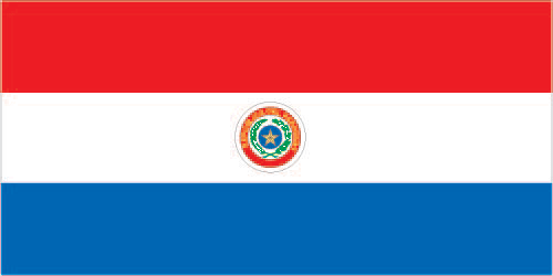
| Flag description: three equal, horizontal bands of red (top), white, and blue with an emblem centered in the white band; unusual flag in that the emblem is different on each side; the obverse (hoist side at the left) bears the national coat of arms (a yellow five-pointed star within a green wreath capped by the words REPUBLICA DEL PARAGUAY, all within two circles); the reverse (hoist side at the right) bears a circular seal of the treasury (a yellow lion below a red Cap of Liberty and the words PAZ Y JUSTICIA (Peace and Justice)); red symbolizes bravery and patriotism, white represents integrity and peace, and blue denotes liberty and generosity. Note: the three color bands resemble those on the flag of the Netherlands; one of only three national flags that differ on their obverse and reverse sides – the others are Moldova and Saudi Arabia. | Border length: total: 4,655 km. Border countries (total: 3): Argentina 2,531 km, Bolivia 753 km, Brazil 1,371 km. |
About Asunción
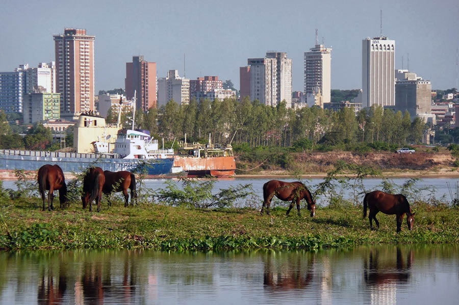
Stand at the corner of Asunción’s Plaza Independencia and Palacio Legislativo, and you’ll see urban South America in all its grisly glory. The peeling pink colonial palace is besieged on one side by a filthy ramshackle slum that tumbles down to the muddy shore of the Rio Paraguay. A stubbly football pitch lies in the distance, and a stained cathedral sits on the other plaza corner, surrounded by potholed streets and vigilant police officers. Dirty buses rumble between whitewashed curbs and a hodge-podge of decaying pastel-colored mansions stand squeezed between squalid concrete bunkers.
Asunción is glorious in the sun and miserable in the rain. Like most South American cities, the downtown area is reduced, polluted, and neglected yet alive with vendors, food stalls, and chaotic traffic. Here you’ll find some fascinating museums and monuments, and the shade they offer is a refreshing respite from the sweltering heat. The northeast of the city becomes decidedly tidier but characterless, with long avenues of car dealerships and shopping malls leading to upscale and leafy Villa Morra. Here you’ll find some beautiful suburban streets and parks.
With a population of 1.2 million people, Asunción has the feel of a provincial city. Founded in 1557, the Spanish had big plans to make it the gateway to Peru. The vast, impenetrable Chaco soon stopped this idea in its tracks, and the city lost its dominance to Buenos Aires and Salta. Thoughtless urban planning saw the destruction of many elegant buildings, and what remains gives a sense of long-faded glory. Nevertheless, it is the political, economic, and cultural center of Paraguay, with most of the country’s population living there or nearby. Those same people are amiable and welcoming, unfamiliar with tourists, and anxious that you enjoy your stay.
Did you know about Paraguay?
- Paraguay declared its independence from Spain in 1811 and has remained an independent republic ever since.
- The War of the Triple Alliance (18641870) killed almost 90% of Paraguays male population.
- Landlocked and with few natural resources, Paraguay is largely agricultural. The majority of people are bilingual, speaking Spanish and Guaraní.
A small country, Paraguay is bounded by land on all sides and divided into two distinct regions by the River Paraguay. Paraguay Occidental is the larger region to the west of the river. It consists of a marshy, alluvial plain which is also part of the Gran Chaco. In the south and east, much of this area is waterlogged swamp, but the land rises gradually and gives way to grassy areas and arid, scrub forest towards the northwestern border.
Paraguay Oriental lies to the east of the Paraguay river and consists mainly of an upland plateau called the Parana Plateau. Paraguay has a subtropical climate and much of the Oriental region covered with thick forests containing numerous varieties of plants and animals. With three important rivers, Paraguay, the Parana, and the Pilcomayo, the country has many impressive waterfalls, such as the Guaira Falls, and, in cooperation with its neighbors, it has developed its potential for hydroelectric power to the extent of fulfilling all its energy needs. The Itaipu Hydroelectric Dam on the (Alto) Parana river, opened in 1991 and developed with Brazil, is one of the largest in the world. Other schemes include the Yacyreta Dam, developed with Argentina and opened in 1994.
Facts of Paraguay (PY)
Name conventional long form: Republic of Paraguay, conventional short form: Paraguay, local long form: Republica del Paraguay, local short form: Paraguay, etymology: the precise meaning of the name Paraguay is unclear, but it seems to derive from the river of the same name; one explanation has the name meaning “water of the Payagua” (an indigenous tribe that lived along the river)
Codes: ISO; PY, Internet; .py
Capital city: Asunción
Language(s): Spanish (official language), Guarani (official language)
National holiday(s): Independence Day, 14 May 1811 (observed 15 May)
Motto: Paz y justicia (Peace and justice)
Currency: Paraguayan guaraní (PYG), since 1943
GPS: 23 00 S, 58 00 W, Asunción; 25 16 S 57 40 W
Location: Central South America, northeast of Argentina, southwest of Brazil
Geography note: landlocked country; lies between Argentina, Bolivia, and Brazil; population concentrated in southern part of country
Land boundaries: Argentina 2,531 km, Bolivia 753 km, Brazil 1,371 km, total: 4,655 km
Maritime boundaries: N/A
Coastline: 0 km (landlocked country)
Area: total: 406,752 sq km; land: 397,302 sq km, water: 9,450 sq km (total 157 047,76 mi2), slightly smaller than California.
Roadways: total: 32,059 km, paved: 4,860 km, unpaved: 27,199 km (2010)
Waterways: 3,100 km (primarily on the Paraguay and Paraná River systems) (2012)
Local time (capital): UTC-4, 1 hour ahead of Washington DC during Standard Time
Note to the local time: Daylight saving time: +1hr begins first Sunday in October; ends fourth Sunday in March
Population in Paraguay: 6 896 908
Population in Asuncion: 2 139 000 (including the metropolitan areas)
Urbanization: urban population: 59.7% of total population (2015)
Major urban areas population: ASUNCION (capital) 2.356 million (2015)
Population growth rate: 1.17% (2016 estimate)
Birth rate: 16.5 births / 1,000 population (2016 estimate)
Death rate: 4.7 deaths / 1,000 population (2016 estimate)
Age structure: 0-14 years: 25.04% (male 874,541 / female 844,212) 15-24 years: 19.74% (male 680,998 / female 673,534) 25-54 years: 40.56% (male 1,392,814 / female 1,390,655) 55-64 years: 7.74% (male 270,769 / female 260,300) 65 years and over: 6.92% (male 222,435 / female 252,554) (2016 estimate)
Median age: total: 27.8 years; male: 27.5 years, female: 28 years (2016 estimate)
Ethnic groups: mestizo (mixed Spanish and Amerindian) 95%, other 5%
Religions: Roman Catholic 89.6%, Protestant 6.2%, other Christian 1.1%, other or unspecified 1.9%, none 1.1% (2002 census)
Government type: Unitary presidential constitutional republic
Legal system: civil law system with influences from Argentine, Spanish, Roman, and French civil law models; judicial review of legislative acts in Supreme Court of Justice
National anthem: Paraguayos, República o Muerte (Paraguayans, Republic or Death)
Known national hazards: local flooding in southeast (early September to June); poorly drained plains may become boggy (early October to June)
Major infectious diseases: The degree of risk(s): intermediatefood or waterborne diseases: bacterial diarrhea, hepatitis A, and typhoid fever vectorborne disease: dengue fever. Note: active local transmission of Zika virus by Aedes species mosquitoes has been identified in this country (as of August 2016); it poses an important risk (a large number of cases possible) among US citizens if bitten by an infective mosquito; other less common ways to get Zika are through sex, via blood transfusion, or during pregnancy, in which the pregnant woman passes Zika virus to her fetus (2016)
Land use: agricultural land: 53.8%; arable land 10.8%; permanent crops 0.2%; permanent pasture 42.8%; forest: 43.8%; other: 2.4% (2011 estimate)
Agricultural products: cotton, sugarcane, soybeans, corn, wheat, tobacco, cassava (manioc, tapioca), fruits, vegetables; beef, pork, eggs, milk; timber
Industries: sugar, cement, textiles, beverages, wood products, steel, base metals, electric power
Export commodities: soybeans, livestock feed, cotton, meat, edible oils, wood, leather
Main export partners: Brazil 31.7%, Russia 9.1%, Chile 7.1%, Argentina 7% (2015)
Import commodities: road vehicles, consumer goods, tobacco, petroleum products, electrical machinery, tractors, chemicals, vehicle parts
Main import partners: Brazil 25.4%, China 23.7%, Argentina 14.8%, US 7.9% (2015)
Navigate the countries in South America faster and easier while driving, use the interactive Google maps for your driving directions. The continuously updated database contains over 220 countries and territories digitally mapped, hundreds of millions of businesses and places around the world positioned on the map.
Get fresh GPS navigation, traffic, and transit information – no matter what part of Paraguay, Asunción, any other city and country in America, or the world you’re in.
Do you like this Paraguay information page? Please don’t forget to share it with others! Thank you.