Colombia Google maps and Driving Directions
Get free driving directions, Google maps, traffic information for Colombia, and Bogota (GPS: 4 36 N 74 05 W), the capital city of the country located in (the) Northern South America, bordering the Caribbean Sea, between Panama and Venezuela, and bordering the North Pacific Ocean, between Ecuador and Panama.
Find any address in Bogota on the Google map of Colombia (CO) with ease or calculate your up to date itinerary to and from Colombia or its neighboring counties like Brazil, Ecuador, Panama, Peru, Venezuela.
Sightseeing and exploring in America starts here, thanks to Google because its Earth Engine combines a multi-petabyte catalog of updated satellite imagery and geospatial datasets with planetary-scale analysis capabilities. Wonder the world, use the satellite map function of the Google maps to explore or see differences on the Earth’s surface, inland, or the surrounding areas of Colombia.
Google Maps Colombia
Lying in northwest South America, Colombia has coastlines on both the Caribbean and the Pacific. It is primarily noted for its coffee, emeralds, gold, and cocaine trafficking.
Colombia is flat coastal lowlands, central highlands, high Andes Mountains, eastern lowland plains (Llanos).
The map above fully covers Colombia with its road routes from cities to towns, road intersections in any region, provinces, prefectures, also with free driving directions in Bogota or to the neighboring towns and countries. To look at the detailed map about a particular quarter in Bogota, please click on the area and zoom to the place you are interested in the Google maps of Colombia (CO).
Be creative, use the extras of this Google map; This is a detailed, clear, zoomable, large road map of Colombia with its administrative divisions; 32 departments (departamentos, singular – departamento) and 1 capital district* (distrito capital); Amazonas, Antioquia, Arauca, Atlantico, Bogota*, Bolivar, Boyaca, Caldas, Caqueta, Casanare, Cauca, Cesar, Choco, Cordoba, Cundinamarca, Guainia, Guaviare, Huila, La Guajira, Magdalena, Meta, Narino, Norte de Santander, Putumayo, Quindio, Risaralda, Archipielago de San Andres, Providencia y Santa Catalina (colloquially San Andres y Providencia), Santander, Sucre, Tolima, Valle del Cauca, Vaupes, Vichada.
The interactive map above is also may be used as the satellite map of Colombia, or as a reverse search map for finding an address from its GPS coordinates.
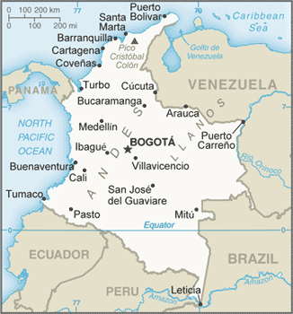
Colombia is bordered on the northwest by Panama, on the east by Venezuela and Brazil, and on the southwest by Peru and Ecuador. Through the western half of the country, three Andean ranges run north and south. The eastern half is a low, jungle-covered plain, drained by spurs of the Amazon and Orinoco Rivers, inhabited mostly by isolated tropical-forest Indian tribes. The fertile plateau and valley of the eastern range are the most densely populated parts of the country. Colombia shares borders with five neighboring countries. In order of shared border length, these are: Venezuela (2,050km), Brazil (1,643 km), Peru (1,496 km), Ecuador (590 km), and Panama (225 km).
Colombia (area: 1 141 750 sq km / 440 831,96 sq mi), where the official language is Spanish, lying in America and using the currency; Colombian peso (COP), since 1880, set their clock to UTC-5. That means they are same time as Washington DC during Standard Time in Bogota, the capital. Note to the time difference: N/A.
The climate in Colombia; Coastal plains are hot and wet. The highlands are much cooler. The equatorial east has two wet seasons.
Geography in a nutshell; The densely forested and almost uninhabited east is separated from the western coastal plains by the Andes, which divide into three ranges (cordilleras) with intervening valleys.
Click here for more detailed information about Colombia.
Driving directions Colombia
The Google maps and Google Satellite maps of Colombia above showing the country, located next to Brazil, Ecuador, Panama, Peru, Venezuela. For your further reference, the latitude and longitude coordinates of Colombia are 4 00 N, 72 00 W , while the capital, Bogota found at 4 36 N 74 05 W.
When you are traveling around Colombia, Bogota, or its other cities, use this routing tool, providing up to date route planning service free of charge.
Look no further; get accurate driving directions in Colombia, South America, by filling the route planner form below.
Since Google acquired and introduced its digitalized maps in 2004, you’re probably familiar with its base functions, like finding an address or driving directions to locations. Still, Google maps also accommodate bicyclists, pedestrians, and also public transportation with special directions and customizable routes.
About Colombia and the capital, Bogota
 |
 |
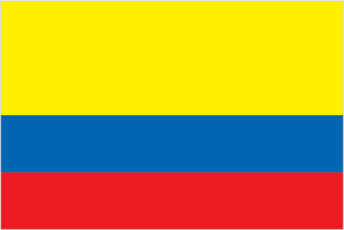
| The national flag of Colombia | Borderline map of Colombia |
| Flag description: three horizontal bands of yellow (top, double-width), blue, and red; the flag retains the three main colors of the banner of Gran Colombia, the short-lived South American republic that broke up in 1830; various interpretations of the colors exist and include: yellow for the gold in Colombia’s land, blue for the seas on its shores, and red for the blood spilled in attaining freedom; alternatively, the colors have been described as representing more elemental concepts such as sovereignty and justice (yellow), loyalty and vigilance (blue), and valor and generosity (red); or simply the principles of liberty, equality, and fraternity. Note: similar to the flag of Ecuador, which is longer and bears the Ecuadorian coat of arms superimposed in the center. | Border length: total: 6,672 km. Border countries (total: 5): Brazil 1,790 km, Ecuador 708 km, Panama 339 km, Peru 1,494 km, Venezuela 2,341 km. |
About Bogotá
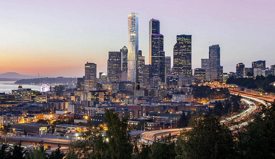
At first sight, Bogotá may not impress you. The constant rain, chilliness, and ominous pine-forest mountains make London seem downright sunny. But give Bogotá time, and you will discover a sophisticated city of skyscrapers, glitzy upscale shopping centers, restaurants to satisfy even the most discerning palettes, and a nightlife that will leave you needing a vacation from your vacation. Colombia’s capital, and by far the country’s largest city, Bogotá is a sprawling metropolis, home to eclectic, experimental architecture, a sizeable bohemian university crowd, a lively cafe scene, and dozens of attractive city parks. It is a city bursting with energy and culture.
But it’s not all good news. Bogotá is, more than anything, a city of contrasts. Class differences are still very much apparent, with the wealthy, modern northern section a world apart from the sprawling slums, poverty, and high crime rates of the southern part of the city. Though security has improved dramatically in the last few years, the city center can still be dangerous at night, so you’re better off not wearing expensive-looking jewelry and clothing when visiting these areas. However, Bogotá is one of Latin America’s safer cities, and it’s unlikely you’ll encounter any serious problems.
Did you know about Colombia?
- Following years of Spanish rule, Colombia became part of independent Greater Colombia in 1819, and then a separate republic in 1830.
- Over 50% of the worlds cocaine is produced in Colombia.
- Colombia is one of the richest countries in South America, with quantities of gold, emeralds, vast energy reserves, and a climate that supports two crops a year.
Columbia is situated in the northwestern part of South America and is unique in having a coastline that borders both the Pacific Ocean and the Caribbean Sea. The dominant topographical feature is the Andes mountain chain. However, Colombia’s highest mountain, Pico Cristobel Colon, is not in the Andes but in a separate group of mountains called the Sierra Nevada de Santa Marta, situated just behind the Caribbean coast. The northern part of Colombia, to the east of the Andes, comprises a region of grassy plains or Llanos which is drained by many tributaries of the Orinoco river. Farther south, this gives way to dense rainforests drained by tributaries of the Amazon.
Colombia has a wealth of habitats that provide a home for many different types of plants and animals. Colombia’s most important crop is coffee, but bananas, sugar cane, rice, cacao beans, flowers, cotton, tobacco, and potatoes also cultivated. The country has important natural reserves of minerals and precious stones, particularly emeralds, silver, gold, petroleum, coal, natural gas, platinum, nickel, and copper.
Facts of Colombia (CO)
Name conventional long form: Republic of Colombia, conventional short form: Colombia, local long form: Republica de Colombia, local short form: Colombia, etymology: the country named after explorer Christopher COLUMBUS
Codes: ISO; CO, Internet; .co
Capital city: Bogota
Language(s): Spanish (official language)
National holiday(s): Independence Day, 20 July (1810)
Motto: Libertad y orden (Freedom and Order)
Currency: Colombian peso (COP), since 1880
GPS: 4 00 N, 72 00 W, Bogota; 4 36 N 74 05 W
Location: Northern South America, bordering the Caribbean Sea, between Panama and Venezuela, and bordering the North Pacific Ocean, between Ecuador and Panama
Geography note: only South American country with coastlines on both the North Pacific Ocean and Caribbean Sea
Land boundaries: Brazil 1,790 km, Ecuador 708 km, Panama 339 km, Peru 1,494 km, Venezuela 2,341 km, total: 6,672 km
Maritime boundaries: N/A
Coastline: 3,208 km (Caribbean Sea 1,760 km, North Pacific Ocean 1,448 km)
Area: total: 1,138,910 sq km; land: 1,038,700 sq km, water: 100,210 sq km (total 440 831,96 mi2), slightly less than twice the size of Texas.
Roadways: total: 204,855 km (2015)
Waterways: 24,725 km (18,300 km navigable; the most important waterway, the River Magdalena, of which 1,488 km is navigable, is dredged regularly to ensure safe passage of cargo vessels and container barges) (2012)
Local time (capital): UTC-5, same time as Washington DC during Standard Time
Note to the local time: N/A
Population in Colombia: 49 464 683
Population in Bogota: 7 594 000 (including the metropolitan areas)
Urbanization: urban population: 76.4% of total population (2015)
Major urban areas population: BOGOTA (capital) 9.765 million; Medellin 3.911 million; Cali 2.646 million; Barranquilla 1.991 million; Bucaramanga 1.215 million; Cartagena 1.092 million (2015)
Population growth rate: 1.02% (2016 estimate)
Birth rate: 16.3 births / 1,000 population (2016 estimate)
Death rate: 5.4 deaths / 1,000 population (2016 estimate)
Age structure: 0-14 years: 24.57% (male 5,940,903 / female 5,659,594) 15-24 years: 17.54% (male 4,216,437 / female 4,066,079) 25-54 years: 41.82% (male 9,788,057 / female 9,958,982) 55-64 years: 8.9% (male 1,973,215 / female 2,230,609) 65 years and over: 7.17% (male 1,412,209 / female 1,974,771) (2016 estimate)
Median age: total: 29.6 years; male: 28.7 years, female: 30.6 years (2016 estimate)
Ethnic groups: mestizo and white 84.2%, Afro-Colombian (includes multatto, Raizal, and Palenquero) 10.4%, Amerindian 3.4%, Roma
Religions: Roman Catholic 90%, other 10%
Government type: Unitary presidential constitutional republic
Legal system: civil law system influenced by the Spanish and French civil codes
National anthem: Himno nacional de Colombia
Known national hazards: highlands subject to volcanic eruptions; occasional earthquakes; periodic droughtsvolcanism: Galeras (elev. 4,276 m) is one of Colombia’s most active volcanoes, having erupted in 2009 and 2010 causing major evacuations; it has been deemed a Decade Volcano by the International Association of Volcanology and Chemistry of the Earth’s Interior, worthy of study due to its explosive history and proximity to human populations; Nevado del Ruiz (elev. 5,321 m), 129 km (80 mi) west of Bogota, erupted in 1985 producing lahars (mudflows) that killed 23,000 people; the volcano last erupted in 1991; additionally, after 500 years of dormancy, Nevado del Huila reawakened in 2007 and has experienced frequent eruptions since then; other historically active volcanoes include Cumbal, Dona Juana, Nevado del Tolima, and Purace
Major infectious diseases: The degree of risk(s): high food or waterborne diseases: bacterial diarrheavectorborne diseases: dengue fever, malaria, and yellow fever. Note: active local transmission of Zika virus by Aedes species mosquitoes has been identified in this country (as of August 2016); it poses an important risk (a large number of cases possible) among US citizens if bitten by an infective mosquito; other less common ways to get Zika are through sex, via blood transfusion, or during pregnancy, in which the pregnant woman passes Zika virus to her fetus (2016)
Land use: agricultural land: 37.5%; arable land 1.4%; permanent crops 1.6%; permanent pasture 34.5%; forest: 54.4%; other: 8.1% (2011 estimate)
Agricultural products: coffee, cut flowers, bananas, rice, tobacco, corn, sugarcane, cocoa beans, oilseed, vegetables; shrimp; forest products
Industries: textiles, food processing, oil, clothing and footwear, beverages, chemicals, cement; gold, coal, emeralds
Export commodities: petroleum, coal, emeralds, coffee, nickel, cut flowers, bananas, apparel
Main export partners: US 27.5%, Panama 7.2%, China 5.2%, Spain 4.4%, Ecuador 4% (2015)
Import commodities: industrial equipment, transportation equipment, consumer goods, chemicals, paper products, fuels, electricity
Main import partners: US 28.8%, China 18.6%, Mexico 7.1%, Germany 4.2% (2015)
Navigate the countries in South America faster and easier while driving, use the interactive Google maps for your driving directions. The continuously updated database contains over 220 countries and territories digitally mapped, hundreds of millions of businesses and places around the world positioned on the map.
Get fresh GPS navigation, traffic, and transit information – no matter what part of Colombia, Bogota, any other city and country in America, or the world you’re in.
Do you like this Colombia information page? Please don’t forget to share it with others! Thank you.