Argentina Google maps and Driving Directions
Get free driving directions, Google maps, traffic information for Argentina, and Buenos Aires (GPS: 34 36 S 58 22 W), the capital city of the country located in (the) Southern South America, bordering the South Atlantic Ocean, between Chile and Uruguay.
Find any address in Buenos Aires on the Google map of Argentina (AR) with ease or calculate your up to date itinerary to and from Argentina or its neighboring counties like Bolivia, Brazil, Chile, Paraguay, Uruguay.
Sightseeing and exploring in America starts here, thanks to Google because its Earth Engine combines a multi-petabyte catalog of updated satellite imagery and geospatial datasets with planetary-scale analysis capabilities. Wonder the world, use the satellite map function of the Google maps to explore or see differences on the Earth’s surface, inland, or the surrounding areas of Argentina.
Google Maps Argentina
Argentina occupies most of southern South America. After 30 years of intermittent military rule, democracy returned in 1983. Economy has slowed since its recovery from 2001 crash.
Argentina is rich plains of the Pampas in northern half, flat to rolling plateau of Patagonia in south, rugged Andes along western border.
The map above fully covers Argentina with its road routes from cities to towns, road intersections in any region, provinces, prefectures, also with free driving directions in Buenos Aires or to the neighboring towns and countries. To look at the detailed map about a particular quarter in Buenos Aires, please click on the area and zoom to the place you are interested in the Google maps of Argentina (AR).
Be creative, use the extras of this Google map; This is a detailed, clear, zoomable, large road map of Argentina with its administrative divisions; 23 provinces (provincias, singular – provincia) and 1 autonomous city*; Buenos Aires, Catamarca, Chaco, Chubut, Ciudad Autonoma de Buenos Aires*, Cordoba, Corrientes, Entre Rios, Formosa, Jujuy, La Pampa, La Rioja, Mendoza, Misiones, Neuquen, Rio Negro, Salta, San Juan, San Luis, Santa Cruz, Santa Fe, Santiago del Estero, Tierra del Fuego – Antartida e Islas del Atlantico Sur (Tierra del Fuego), Tucuman. Note: the US does not recognize any claims to Antarctica.
The interactive map above is also may be used as the satellite map of Argentina, or as a reverse search map for finding an address from its GPS coordinates.
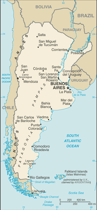
Second in South America only to Brazil in size and population, Argentina is a plain, rising from the Atlantic to the Chilean border and the towering Andes peaks. Aconcagua (22,834 ft, 6,960 m) is the highest peak in the world outside Asia. Argentina is also bordered by Bolivia and Paraguay on the north, and by Uruguay and Brazil on the east. The northern area is the swampy and partly wooded Gran Chaco, bordering Bolivia and Paraguay. South of that are the rolling, fertile Pampas, which are rich in agriculture and sheep- and cattle-grazing and support most of the population. Further south is Patagonia, a region of cool, arid steppes with some wooded and fertile sections.
Argentina (area: 2 780 400 sq km / 1 073 518,00 sq mi), where the official language is Spanish, lying in America and using the currency; Argentine peso (ARS), since 1813, set their clock to UTC-3. That means they are 2 hours ahead of Washington DC during Standard Time in Buenos Aires, the capital. Note to the time difference: N/A.
The climate in Argentina; The Andes are semiarid in the north and snowy in the south. Pampas have a mild climate with summer rains.
Geography in a nutshell; The Andes form a natural border with Chile in the west. East are the heavily wooded plains (Gran Chaco) and treeless but fertile Pampas plains. Bleak and arid Patagonia in the south.
Click here for more detailed information about Argentina.
Driving directions Argentina
The Google maps and Google Satellite maps of Argentina above showing the country, located next to Bolivia, Brazil, Chile, Paraguay, Uruguay. For your further reference, the latitude and longitude coordinates of Argentina are 34 00 S, 64 00 W , while the capital, Buenos Aires found at 34 36 S 58 22 W.
When you are traveling around Argentina, Buenos Aires, or its other cities, use this routing tool, providing up to date route planning service free of charge.
Look no further; get accurate driving directions in Argentina, South America, by filling the route planner form below.
Since Google acquired and introduced its digitalized maps in 2004, you’re probably familiar with its base functions, like finding an address or driving directions to locations. Still, Google maps also accommodate bicyclists, pedestrians, and also public transportation with special directions and customizable routes.
About Argentina and the capital, Buenos Aires
 |
 |
| The national flag of Argentina | Borderline map of Argentina |
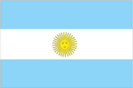
| Flag description: three equal horizontal bands of light blue (top), white, and light blue; centered in the white band is a radiant yellow sun with a human face known as the Sun of May; the colors represent the clear skies and snow of the Andes; the sun symbol commemorates the appearance of the sun through cloudy skies on 25 May 1810 during the first mass demonstration in favor of independence; the sun features are those of Inti, the Inca god of the sun. | Border length: total: 11,968 km. Border countries (total: 5): Bolivia 942 km, Brazil 1,263 km, Chile 6,691 km, Paraguay 2,531 km, Uruguay 541 km. |
About Buenos Aires
Enjoy a European city at a fraction of the price. Buenos Aires has it all – the glamour, the architecture, and the nightlife. Stroll through the neighborhoods of Recoleta or Palermo, full of buildings with neoclassical facades on broad tree-lined boulevards, and you’ll start to understand why this place developed the reputation of being the Paris of South America. European immigrants to Buenos Aires, mostly from Spain and Italy, brought with them the warm ways of Mediterranean culture. Whiling away the night over a great meal is the norm, and locals pack into cafes, restaurants, and bars until the early morning hours.
You’ll find a city of old historical cafes and restaurants competing with new ones opening up at a breakneck pace all over town, particularly in the trendy Palermo district. The city’s post-crisis renaissance has lead to an incredible flourishing of all things Porteño, the word Buenos Aires locals use to describe both themselves and the culture of their city. Unable to import expensive foods from overseas anymore, Buenos Aires’s restaurants are concentrating instead on cooking with Argentine staples such as Pampas grass-fed beef. What has developed is a spectacular array of Argentine-nouvelle cuisine of incredible quality. Chefs can’t seem to produce it fast enough in the ever-expanding variety of Buenos Aires’ restaurants.
This new Argentine self-reliance and pride are not just limited to its restaurants. Importantly, the most Porteño thing of all, the tango, has also witnessed explosive growth. Up until the peso crisis, Argentines worried that the dance would die out, but young Argentines and ex-pats from all over the world who love the tango are making Buenos Aires the world’s new hot city, the way Prague was at the end of the Cold War. The city is also home to an incomparable array of theaters and other traditional venues.
Did you know about Argentina?
- Argentina achieved its independence from Spain in 1816. Liberation demonstrations began in Buenos Aires on May 25, 1810.
- The Tango originated in the poorer quarters of Buenos Aires at the end of the 19th century.
- Traditionally agricultural, the second largest country in South America stretches 2,290 miles (3,694km) from the Gran Chaco region in the north to the island of Tierra del Fuego in the south.
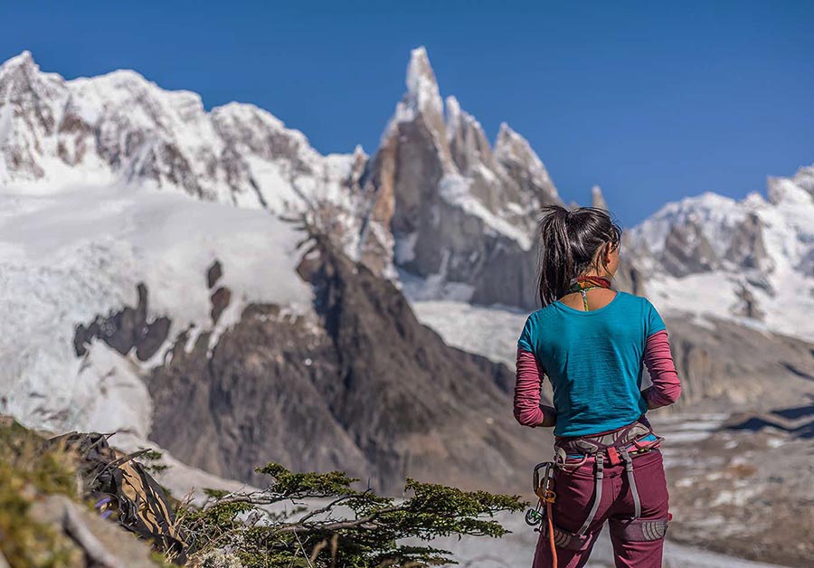
Argentina is a large country which also includes the eastern part of Tierra del Fuego. The dominant topographical feature is the Andes mountain chain occupying the western part of the country, which is broader in the north than in the south. The northern Andes consist of peaks, ridges, and valleys. Some of these peaks are active volcanoes, and others have slopes covered with glaciers surrounding icy, alpine lakes. East of the Andes the land falls away to form undulating plains sloping towards the sea.
In the north, the plains form part of the subtropical region known as the Gran Chaco. In the northeast, in the low-lying Parana river basin, there are tropical swamps and forests inhabited by animals such as monkeys, peccaries, anteaters, snakes, raccoons, tapirs and the large cats – pumas, jaguars, and ocelots. Birds include colorful parrots and hummingbirds.
South of the Chaco is Argentina’s rich and productive agricultural region in the grassy plains known as the Pampas. Farther south is Patagonia, a region of dry, cold steppes with few trees but supporting grasslands that are eminently suitable for the rearing of sheep.
Argentina is relatively wealthy by South American standards, with an economy based on agriculture including a modest wine-making industry. Mineral exploitation, particularly of petroleum, is of growing importance to the economy, as is the development of hydroelectric power.
Facts of Argentina (AR)
Name conventional long form: Argentine Republic, conventional short form: Argentina, local long form: Republica Argentina, local short form: Argentina, etymology: originally the area was referred to as Tierra Argentina, i.e., “Land beside the Silvery River” or “silvery land,” which referred to the massive estuary in the east of the country, the Rio de la Plata (River of Silver); over time the name shortened to simply Argentina or “silvery”
Codes: ISO; AR, Internet; .ar
Capital city: Buenos Aires
Language(s): Spanish (official language), Italian, English, German, French, indigenous (Mapudungun, Quechua)
National holiday(s): Revolution Day, 25 May (1810)
Motto: En Unión y Libertad (In Unity and Freedom)
Currency: Argentine peso (ARS), since 1813
GPS: 34 00 S, 64 00 W, Buenos Aires; 34 36 S 58 22 W
Location: Southern South America, bordering the South Atlantic Ocean, between Chile and Uruguay
Geography note: second-largest country in South America (after Brazil); strategic location relative to sea lanes between the South Atlantic and the South Pacific Oceans (Strait of Magellan, Beagle Channel, Drake Passage); diverse geophysical landscapes range from tropical climates in the north to tundra in the far south; Cerro Aconcagua is the Western Hemisphere’s tallest mountain, while Laguna del Carbon is the lowest point in the Western Hemisphere
Land boundaries: Bolivia 942 km, Brazil 1,263 km, Chile 6,691 km, Paraguay 2,531 km, Uruguay 541 km, total: 11,968 km
Maritime boundaries: N/A
Coastline: 4,989 km
Area: total: 2,780,400 sq km; land: 2,736,690 sq km, water: 43,710 sq km (total 1 073 518,00 mi2), slightly less than three-tenths the size of the US.
Roadways: total: 231,374 km, paved: 69,412 km (includes 734 km of expressways), unpaved: 161,962 km (2004)
Waterways: 11,000 km (2012)
Local time (capital): UTC-3, 2 hours ahead of Washington DC during Standard Time
Note to the local time: N/A
Population in Argentina: 44 688 864
Population in Buenos Aires: 13 349 000 (including the metropolitan areas)
Urbanization: urban population: 91.8% of total population (2015)
Major urban areas population: BUENOS AIRES (capital) 15.18 million; Cordoba 1.511 million; Rosario 1.381 million; Mendoza 1.009 million; San Miguel de Tucuman 910,000; La Plata 846,000 (2015)
Population growth rate: 0.93% (2016 estimate)
Birth rate: 17 births / 1,000 population (2016 estimate)
Death rate: 7.5 deaths / 1,000 population (2016 estimate)
Age structure: 0-14 years: 24.72% (male 5,590,165 / female 5,259,163) 15-24 years: 15.43% (male 3,461,288 / female 3,312,056) 25-54 years: 39.24% (male 8,593,500 / female 8,627,846) 55-64 years: 9.14% (male 1,948,179 / female 2,064,463) 65 years and over: 11.46% (male 2,104,830 / female 2,925,258) (2016 estimate)
Median age: total: 31.5 years; male: 30.3 years, female: 32.7 years (2016 estimate)
Ethnic groups: white (mostly Spanish and Italian) 97%, mestizo (mixed white and Amerindian ancestry), Amerindian, or other non-white groups 3%
Religions: nominally Roman Catholic 92% (less than 20% practicing), Protestant 2%, Jewish 2%, other 4%
Government type: Federal presidential constitutional republic
Legal system: civil law system based on West European legal systems; note – in 2014, Congress passed government-backed reform to the civil code that will go into effect in 2016
National anthem: Himno Nacional Argentino (Argentine National Anthem)
Known national hazards: San Miguel de Tucuman and Mendoza areas in the Andes subject to earthquakes; pamperos are violent windstorms that can strike the pampas and northeast; heavy flooding in some areasvolcanism: volcanic activity in the Andes Mountains along the Chilean border; Copahue (elev. 2,997 m) last erupted in 2000; other historically active volcanoes include Llullaillaco, Maipo, Planchon-Peteroa, San Jose, Tromen, Tupungatito, and Viedma
Major infectious diseases: note: active local transmission of Zika virus by Aedes species mosquitoes has been identified in this country (as of August 2016); it poses an important risk (a large number of cases possible) among US citizens if bitten by an infective mosquito; other less common ways to get Zika are through sex, via blood transfusion, or during pregnancy, in which the pregnant woman passes Zika virus to her fetus (2016)
Land use: agricultural land: 53.9%; arable land 13.9%; permanent crops 0.4%; permanent pasture 39.6%; forest: 10.7%; other: 35.4% (2011 estimate)
Agricultural products: sunflower seeds, lemons, soybeans, grapes, corn, tobacco, peanuts, tea, wheat; livestock
Industries: food processing, motor vehicles, consumer durables, textiles, chemicals and petrochemicals, printing, metallurgy, steel
Export commodities: soybeans and derivatives, petroleum and gas, vehicles, corn, wheat
Main export partners: Brazil 17%, China 8.6%, US 5.9% (2015)
Import commodities: machinery, motor vehicles, petroleum and natural gas, organic chemicals, plastics
Main import partners: Brazil 22.4%, US 16.3%, China 15.5%, Germany 5.1% (2015)
Navigate the countries in South America faster and easier while driving, use the interactive Google maps for your driving directions. The continuously updated database contains over 220 countries and territories digitally mapped, hundreds of millions of businesses and places around the world positioned on the map.
Get fresh GPS navigation, traffic, and transit information – no matter what part of Argentina, Buenos Aires, any other city and country in America, or the world you’re in.
Do you like this Argentina information page? Please don’t forget to share it with others! Thank you.