Guyana Google maps and Driving Directions
Get free driving directions, Google maps, traffic information for Guyana, and Georgetown (GPS: 6 48 N 58 09 W), the capital city of the country located in (the) Northern South America, bordering the North Atlantic Ocean, between Suriname and Venezuela.
Find any address in Georgetown on the Google map of Guyana (GY) with ease or calculate your up to date itinerary to and from Guyana or its neighboring counties like Brazil, Suriname, Venezuela.
Sightseeing and exploring in America starts here, thanks to Google because its Earth Engine combines a multi-petabyte catalog of updated satellite imagery and geospatial datasets with planetary-scale analysis capabilities. Wonder the world, use the satellite map function of the Google maps to explore or see differences on the Earth’s surface, inland, or the surrounding areas of Guyana.
Google Maps Guyana
On the northeast coast of South America, Guyana is the continent’s only English-speaking country. Independent since 1966, it has close ties with the anglophone Caribbean.
Guyana is mostly rolling highlands; low coastal plain; savanna in south.
The map above fully covers Guyana with its road routes from cities to towns, road intersections in any region, provinces, prefectures, also with free driving directions in Georgetown or to the neighboring towns and countries. To look at the detailed map about a particular quarter in Georgetown, please click on the area and zoom to the place you are interested in the Google maps of Guyana (GY).
Be creative, use the extras of this Google map; This is a detailed, clear, zoomable, large road map of Guyana with its administrative divisions; 10 regions; Barima-Waini, Cuyuni-Mazaruni, Demerara-Mahaica, East Berbice-Corentyne, Essequibo Islands-West Demerara, Mahaica-Berbice, Pomeroon-Supenaam, Potaro-Siparuni, Upper Demerara-Berbice, Upper Takutu-Upper Essequibo.
The interactive map above is also may be used as the satellite map of Guyana, or as a reverse search map for finding an address from its GPS coordinates.
Guyana is the size of Idaho and is situated on the northern coast of South America, east of Venezuela, west of Suriname, and north of Brazil. A tropical forest covers more than 80% of the country.
Guyana (area: 214 969 sq km / 82 999,96 sq mi), where the official language is English, lying in America and using the currency; Guyanese dollar (GYD), since 1839, set their clock to UTC-4. That means they are 1 hour ahead of Washington DC during Standard Time in Georgetown, the capital. Note to the time difference: N/A.
The climate in Guyana; Tropical. Coast cooled by sea breezes. Lowlands are hot, wet, and humid. Highlands are a little cooler.
Geography in a nutshell; Mainly artificial coast, reclaimed by dikes and dams from swamps and tidal marshes. Forests cover 85% of the interior, rising to savanna uplands and mountains.
Click here for more detailed information about Guyana.
Driving directions Guyana
The Google maps and Google Satellite maps of Guyana above showing the country, located next to Brazil, Suriname, Venezuela. For your further reference, the latitude and longitude coordinates of Guyana are 5 00 N, 59 00 W , while the capital, Georgetown found at 6 48 N 58 09 W.
When you are traveling around Guyana, Georgetown, or its other cities, use this routing tool, providing up to date route planning service free of charge.
Look no further; get accurate driving directions in Guyana, South America, by filling the route planner form below.
Since Google acquired and introduced its digitalized maps in 2004, you’re probably familiar with its base functions, like finding an address or driving directions to locations. Still, Google maps also accommodate bicyclists, pedestrians, and also public transportation with special directions and customizable routes.
About Guyana and the capital, Georgetown
 |
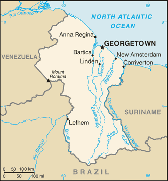 |
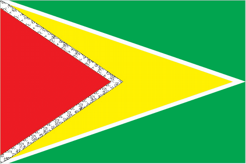
| The national flag of Guyana | Borderline map of Guyana |
| Flag description: green with a red isosceles triangle (based on the hoist side) superimposed on a long, yellow arrowhead; there is a narrow, black border between the red and yellow, and a narrow, white border between the yellow and the green; green represents forest and foliage; yellow stands for mineral resources and a bright future; white symbolizes Guyana’s rivers; red signifies zeal and the sacrifice of the people; black indicates perseverance. | Border length: total: 2,933 km. Border countries (total: 3): Brazil 1,308 km, Suriname 836 km, Venezuela 789 km. |
Did you know about Guyana?
- Guyana acquired by the UK in 1814. It became independent in 1966 and a republic within the Common wealth in 1970.
- The British concentrated on growing sugar. Today, it remains famous for its Demerara sugar.
- Guyana means “land of many waters, reflecting its dense network of rivers.”
Inland from Guyana’s coastal belt, there lies a densely forested region that covers about four-fifths of the total land area. In the north and the southwest, the forests give way to the high savannah of the Rapununi and Kanaku regions. In the western, central part of the country lie the Guiana Highlands with their table-top peaks.
As the name suggests, French Guiana remains an overseas department of France, and the country’s inhabitants have enjoyed a relatively high standard of living thanks to supporting from France.
The coastal belt is a narrow strip of marshy mangrove swamps, and then the land gradually rises inland towards the Tumac-Humac Mountains. Behind the coast there is some savannah, but 90 percent of French Guiana is covered with hot, humid, tropical forest where animals such as tapirs, monkeys, anteaters, jaguars, ocelots, caimans and exotic birds found. Most of the population are engaged either in agriculture, fishing, forestry, or mining. French Guiana has one extremely modern development-the satellite launch base at Kourou, jointly run by the European Space Agency, the French Space Agency, and Arianespace, a company responsible for the Ariane rocket.
Facts of Guyana (GY)
Name conventional long form: Cooperative Republic of Guyana, conventional short form: Guyana, former: British Guiana, etymology: the name is derived from Guiana, the original name for the region that included British Guiana, Dutch Guiana, and French Guiana; ultimately the word is derived from an indigenous Amerindian language and means “land of many waters” (referring to the area’s multitude of rivers and streams)
Codes: ISO; GY, Internet; .gy
Capital city: Georgetown
Language(s): English (official language), Guyanese Creole, Amerindian languages (including Caribbean and Arawak languages), Indian languages (including Caribbean Hindustani, a dialect of Hindi), Chinese (2014 estimate)
National holiday(s): Republic Day, 23 February (1970)
Motto: One People, One Nation, One Destiny
Currency: Guyanese dollar (GYD), since 1839
GPS: 5 00 N, 59 00 W, Georgetown; 6 48 N 58 09 W
Location: Northern South America, bordering the North Atlantic Ocean, between Suriname and Venezuela
Geography note: the third-smallest country in South America after Suriname and Uruguay; substantial portions of its western and eastern territories are claimed by Venezuela and Suriname respectively
Land boundaries: Brazil 1,308 km, Suriname 836 km, Venezuela 789 km, total: 2,933 km
Maritime boundaries: N/A
Coastline: 459 km
Area: total: 214,969 sq km; land: 196,849 sq km, water: 18,120 sq km (total 82 999,96 mi2), slightly smaller than Idaho.
Roadways: total: 7,970 km, paved: 590 km, unpaved: 7,380 km (2001)
Waterways: 330 km (the Berbice, Demerara, and Essequibo Rivers are navigable by oceangoing vessels for 150 km, 100 km, and 80 km respectively) (2012)
Local time (capital): UTC-4, 1 hour ahead of Washington DC during Standard Time
Note to the local time: N/A
Population in Guyana: 782 225
Population in Georgetown: 227 700 (including the metropolitan areas)
Urbanization: urban population: 28.6% of total population (2015)
Major urban areas population: GEORGETOWN (capital) 124,000 (2014)
Population growth rate: 0.17% (2016 estimate)
Birth rate: 15.5 births / 1,000 population (2016 estimate)
Death rate: 7.4 deaths / 1,000 population (2016 estimate)
Age structure: 0-14 years: 27.12% (male 101,637 / female 97,970) 15-24 years: 21.46% (male 81,017 / female 76,912) 25-54 years: 37.73% (male 145,003 / female 132,640) 55-64 years: 7.9% (male 26,195 / female 31,924) 65 years and over: 5.79% (male 17,585 / female 25,026) (2016 estimate)
Median age: total: 25.8 years; male: 25.5 years, female: 26.2 years (2016 estimate)
Ethnic groups: East Indian 43.5%, black (African) 30.2%, mixed 16.7%, Amerindian 9.1%, other 0.5% (includes Portuguese, Chinese, white) (2002 estimate)
Religions: Protestant 30.5% (Pentecostal 16.9%, Anglican 6.9%, Seventh Day Adventist 5%, Methodist 1.7%), Hindu 28.4%, Roman Catholic 8.1%, Muslim 7.2%, Jehovah’s Witness 1.1%, other Christian 17.7%, other 1.9%, none 4.3%, unspecified 0.9% (2002 estimate)
Government type: Unitary presidential republic
Legal system: common law system, based on the English model, with some Roman-Dutch civil law influence
National anthem: Dear Land of Guyana, of Rivers and Plains
Known national hazards: flash flood threat during rainy seasons
Major infectious diseases: The degree of risk(s): very high food or waterborne diseases: bacterial and protozoal diarrhea, hepatitis A, and typhoid fever vectorborne diseases: dengue fever and malaria. Note: active local transmission of Zika virus by Aedes species mosquitoes has been identified in this country (as of August 2016); it poses an important risk (a large number of cases possible) among US citizens if bitten by an infective mosquito; other less common ways to get Zika are through sex, via blood transfusion, or during pregnancy, in which the pregnant woman passes Zika virus to her fetus (2016)
Land use: agricultural land: 8.4%; arable land 2.1%; permanent crops 0.1%; permanent pasture 6.2%; forest: 77.4%; other: 14.2% (2011 estimate)
Agricultural products: sugarcane, rice, edible oils; beef, pork, poultry; shrimp, fish
Industries: bauxite, sugar, rice milling, timber, textiles, gold mining
Export commodities: sugar, gold, bauxite, alumina, rice, shrimp, molasses, rum, timber
Main export partners: US 33.5%, Canada 17.9%, UK 6.7%, Ukraine 4.3%, Jamaica 4% (2015)
Import commodities: manufactures, machinery, petroleum, food
Main import partners: US 24.6%, Trinidad and Tobago 24.1%, China 10.8%, Suriname 9.5% (2015)
Navigate the countries in South America faster and easier while driving, use the interactive Google maps for your driving directions. The continuously updated database contains over 220 countries and territories digitally mapped, hundreds of millions of businesses and places around the world positioned on the map.
Get fresh GPS navigation, traffic, and transit information – no matter what part of Guyana, Georgetown, any other city and country in America, or the world you’re in.
Do you like this Guyana information page? Please don’t forget to share it with others! Thank you.