Peru Google maps and Driving Directions
Get free driving directions, Google maps, traffic information for Peru, and Lima (GPS: 12 03 S 77 03 W), the capital city of the country located in (the) Western South America, bordering the South Pacific Ocean, between Chile and Ecuador.
Find any address in Lima on the Google map of Peru (PE) with ease or calculate your up to date itinerary to and from Peru or its neighboring counties like Bolivia, Brazil, Chile, Colombia, Ecuador.
Sightseeing and exploring in America starts here, thanks to Google because its Earth Engine combines a multi-petabyte catalog of updated satellite imagery and geospatial datasets with planetary-scale analysis capabilities. Wonder the world, use the satellite map function of the Google maps to explore or see differences on the Earth’s surface, inland, or the surrounding areas of Peru.
Google Maps Peru
Once the heart of the Inca Empire, before the Spanish conquest in the 16th century, Peru lies on the Pacific coast of South America, just south of the equator.
Peru is western coastal plain (costa), high and rugged Andes in center (sierra), eastern lowland jungle of Amazon Basin (selva).
The map above fully covers Peru with its road routes from cities to towns, road intersections in any region, provinces, prefectures, also with free driving directions in Lima or to the neighboring towns and countries. To look at the detailed map about a particular quarter in Lima, please click on the area and zoom to the place you are interested in the Google maps of Peru (PE).
Be creative, use the extras of this Google map; This is a detailed, clear, zoomable, large road map of Peru with its administrative divisions; 25 regions (regiones, singular – region) and 1 province* (provincia); Amazonas, Ancash, Apurimac, Arequipa, Ayacucho, Cajamarca, Callao, Cusco, Huancavelica, Huanuco, Ica, Junin, La Libertad, Lambayeque, Lima, Lima*, Loreto, Madre de Dios, Moquegua, Pasco, Piura, Puno, San Martin, Tacna, Tumbes, Ucayali. Note: Callao, the largest port in Peru, is also referred to as a constitutional province, the only province of the the Callao region.
The interactive map above is also may be used as the satellite map of Peru, or as a reverse search map for finding an address from its GPS coordinates.
Peru, in western South America, extends for nearly 1,500 mi (2,414 km) along the Pacific Ocean. Colombia and Ecuador are to the north, Brazil and Bolivia to the east, and Chile to the south. Five-sixths the size of Alaska, Peru is divided by the Andes Mountains into three sharply differentiated zones. To the west is the coastline, much of it arid, extending 50 to 100 mi (80 to 160 km) inland. The mountain area, with peaks over 20,000 ft (6,096 m), lofty plateaus, and deep valleys, lies centrally. Beyond the mountains to the east is the heavily forested slope leading to the Amazonian plains. Peru shares borders with five neighboring countries. In order of shared border length, these are: Bolivia (900 km), Brazil (1,560 km), Chile (160 km), Colombia (1,496 km), and Ecuador (1,420 km).
Peru (area: 1 285 220 sq km / 496 226,01 sq mi), where the official language is Aymara, Quechua, Spanish, lying in America and using the currency; Peruvian sol (PEN), since 1991, set their clock to UTC-5. That means they are same time as Washington DC during Standard Time in Lima, the capital. Note to the time difference: N/A.
The climate in Peru; Coast is mainly arid. Middle slopes of the Andes are temperate; higher peaks are snow-covered. East is hot, humid, and very wet.
Geography in a nutshell; Coastal plain rises to Andes Mountains. Uplands, dissected by fertile valleys, lie east of the Andes. Tropical forest in extreme east.
Click here for more detailed information about Peru.
Driving directions Peru
The Google maps and Google Satellite maps of Peru above showing the country, located next to Bolivia, Brazil, Chile, Colombia, Ecuador. For your further reference, the latitude and longitude coordinates of Peru are 10 00 S, 76 00 W , while the capital, Lima found at 12 03 S 77 03 W.
When you are traveling around Peru, Lima, or its other cities, use this routing tool, providing up to date route planning service free of charge.
Look no further; get accurate driving directions in Peru, South America, by filling the route planner form below.
Since Google acquired and introduced its digitalized maps in 2004, you’re probably familiar with its base functions, like finding an address or driving directions to locations. Still, Google maps also accommodate bicyclists, pedestrians, and also public transportation with special directions and customizable routes.
About Peru and the capital, Lima
 |
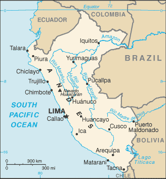 |
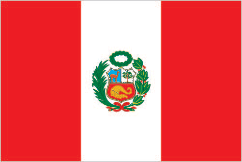
| The national flag of Peru | Borderline map of Peru |
| Flag description: three equal, vertical bands of red (hoist side), white, and red with the coat of arms centered in the white band; the coat of arms features a shield bearing a vicuna (representing fauna), a cinchona tree (the source of quinine, signifying flora), and a yellow cornucopia spilling out coins (denoting mineral wealth); red recalls bloodshed for independence, white symbolizes peace. | Border length: total: 7,062 km. Border countries (total: 5): Bolivia 1,212 km, Brazil 2,659 km, Chile 168 km, Colombia 1,494 km, Ecuador 1,529 km. |
About Lima
Lima was the wealthiest and most important city in the Americas in the 17th century and was considered the most beautiful colonial settlement in the region. Today, the capital of Peru is a sprawling, chaotic, and mostly unlovely metropolis and many visitors dart through it rather quickly or bypass it altogether. Peru’s blistering poverty is more apparent here than perhaps anywhere else: Depressing shantytowns called pueblos jóvenes lacerate the outer rings of the city, and the despair of a large segment of the most abundant migrant and mestizo population contrasts uncomfortably with the luxurious apartment and office buildings in the residential suburbs. If that’s not enough, for most of the year, and unrelenting gray cloud called the garúa hangs massive overhead, obscuring the coastline and dulling the city’s appearance. The sun comes out in Lima only from December to April; the rest of the time, Lima makes London look like Lisbon.
With a population of more than eight million – about one-third of Peru’s total population – and as the seat of the national government and headquarters of most industry, Lima thoroughly dominates Peru’s political and commercial life. Lima demands some effort to sift beneath the soot and uncover the city’s rewards, especially when such extraordinary treasures hover over the horizon in the Andes and the Amazon jungle. So why come to Lima except to beeline it to Cusco or elsewhere? If you skip Lima altogether, you’ll miss a vital part of what Peru is today. Lima has calmed down since its days as a cauldron of chaos in the 1980s and 1990s. The country’s most beautiful museums are here, as are its fanciest and most creative restaurants and its most vibrant nightlife. Many of the classic colonial buildings in the old Lima Centro refurbished. But the city still feels schizophrenic; outer suburbs such as Barranco are relatively gentle oases, worlds removed from the congestion and grime of the rest of the city.
Even if you have only a day or two for Lima, the city’s art and archaeology museums serve as perfect introductions to the rich history and culture you’ll encounter elsewhere in the country. If you also squeeze in a tour of colonial Lima, dine at an excellent criollo restaurant or cevichería, soak up some energetic nightlife, and browse the country’s best shops, you may just come away from Lima pleasantly surprised, even if not exactly enamored of the city.
Did you know about Peru?
- Peru freed from Spanish rule in 1819 by an army led by José de San Martín. Since 1824 it has been an independent unitary republic.
- Lake Titicaca is the worlds highest navigable lake.
- Most Peruvians are Amerindians and descendants of the Incas who ruled the region 400 years ago. Others are mestizo (mixed race), and a few are of European descent. The country is rich in mineral resources and is mainly agricultural.
Peru, the “land of the Incas”, is one of the largest of the South American countries and has four topographical regions that run largely north to south. The Costa, a narrow coastal belt, is a dry, desert region except where it traversed by rivers flowing westward to the Pacific. The valleys of these rivers cultivated for rice, cotton and sugar cane. Behind the coastal belt, the land rises to the high peaks of the Andes, which are cut by steep-sided gorges interspersed with plateaux.
Most of Peru’s native Indian peoples live in this region. On the lower western slopes of the Andes, some cultivation is possible, and the higher regions provide grazing for llamas, alpacas, guanacos, and vicunas. On the eastern side of the Andes lies the Montana region, an area of subtropical jungle and cloud forest that remains virtually impenetrable in some places. To the east and north, the land flattens to form the Selva, a part of the Amazon basin covered with dense tropical jungle.
Facts of Peru (PE)
Name conventional long form: Republic of Peru, conventional short form: Peru, local long form: Republica del Peru, local short form: Peru, etymology: exact meaning is obscure, but the name may derive from a native word “biru” meaning “river”
Codes: ISO; PE, Internet; .pe
Capital city: Lima
Language(s): Spanish (official language) 84.1%, Quechua (official language) 13%, Aymara (official language) 1.7%, Ashaninka 0.3%, other native languages (includes a large number of minor Amazonian languages) 0.7%, other (includes foreign languages and sign language) 0.2% (2007 estimate)
National holiday(s): Independence Day, 28 July (1821)
Motto: Firme y feliz por la unión (Firm and Happy for the Union)
Currency: Peruvian sol (PEN), since 1991
GPS: 10 00 S, 76 00 W, Lima; 12 03 S 77 03 W
Location: Western South America, bordering the South Pacific Ocean, between Chile and Ecuador
Geography note: shares control of Lago Titicaca, world’s highest navigable lake, with Bolivia; a remote slope of Nevado Mismi, a 5,316 m peak, is the ultimate source of the Amazon River
Land boundaries: Bolivia 1,212 km, Brazil 2,659 km, Chile 168 km, Colombia 1,494 km, Ecuador 1,529 km, total: 7,062 km
Maritime boundaries: N/A
Coastline: 2,414 km
Area: total: 1,285,216 sq km; land: 1,279,996 sq km, water: 5,220 sq km (total 496 226,01 mi2), almost twice the size of Texas; slightly smaller than Alaska.
Roadways: total: 140,672 km (18,699 km paved). Note: includes 24,593 km of national roads (14,748 km paved), 24,235 km of departmental roads (2,340 km paved), and 91,844 km of local roads (1,611 km paved) (2012)
Waterways: 8,808 km (8,600 km of navigable tributaries on the Amazon system and 208 km on Lago Titicaca) (2011)
Local time (capital): UTC-5, same time as Washington DC during Standard Time
Note to the local time: N/A
Population in Peru: 32 551 815
Population in Lima: 9 130 000 (including the metropolitan areas)
Urbanization: urban population: 78.6% of total population (2015)
Major urban areas population: LIMA (capital) 9.897 million; Arequipa 850,000; Trujillo 798,000 (2015)
Population growth rate: 0.96% (2016 estimate)
Birth rate: 18 births / 1,000 population (2016 estimate)
Death rate: 6 deaths / 1,000 population (2016 estimate)
Age structure: 0-14 years: 26.62% (male 4,164,681 / female 4,019,436) 15-24 years: 18.63% (male 2,868,743 / female 2,859,476) 25-54 years: 39.91% (male 5,892,065 / female 6,377,681) 55-64 years: 7.62% (male 1,135,938 / female 1,205,579) 65 years and over: 7.21% (male 1,049,409 / female 1,168,054) (2016 estimate)
Median age: total: 27.7 years; male: 26.9 years, female: 28.4 years (2016 estimate)
Ethnic groups: Amerindian 45%, mestizo (mixed Amerindian and white) 37%, white 15%, black, Japanese, Chinese, and other 3%
Religions: Roman Catholic 81.3%, Evangelical 12.5%, other 3.3%, none 2.9% (2007 estimate)
Government type: Unitary presidential constitutional republic
Legal system: civil law system
National anthem: Somos libres, seámoslo siempre (We are free! May we always be so)
Known national hazards: earthquakes, tsunamis, flooding, landslides, mild volcanic activityvolcanism: volcanic activity in the Andes Mountains; Ubinas (elev. 5,672 m), which last erupted in 2009, is the country’s most active volcano; other historically active volcanoes include El Misti, Huaynaputina, Sabancaya, and Yucamane
Major infectious diseases: The degree of risk(s): very high food or waterborne diseases: bacterial diarrhea, hepatitis A, and typhoid fever vectorborne disease: dengue fever, malaria, and Bartonellosis (Oroya fever). Note: active local transmission of Zika virus by Aedes species mosquitoes has been identified in this country (as of August 2016); it poses an important risk (a large number of cases possible) among US citizens if bitten by an infective mosquito; other less common ways to get Zika are through sex, via blood transfusion, or during pregnancy, in which the pregnant woman passes Zika virus to her fetus (2016)
Land use: agricultural land: 18.8%; arable land 3.1%; permanent crops 1.1%; permanent pasture 14.6%; forest: 53%; other: 28.2% (2011 estimate)
Agricultural products: artichokes, asparagus, avocados, blueberries, coffee, cocoa, cotton, sugarcane, rice, potatoes, corn, plantains, grapes, oranges, pineapples, guavas, bananas, apples, lemons, pears, coca, tomatoes, mangoes, barley, medicinal plants, quinoa, palm oil, mari
Industries: mining and refining of minerals; steel, metal fabrication; petroleum extraction and refining, natural gas and natural gas liquefaction; fishing and fish processing, cement, glass, textiles, clothing, food processing, beer, soft drinks, rubber, machinery,
Export commodities: copper, gold, lead, zinc, tin, iron ore, molybdenum, silver; crude petroleum and petroleum products, natural gas; coffee, asparagus and other vegetables, fruit, apparel and textiles, fishmeal, fish, chemicals, fabricated metal products and machinery, allo
Main export partners: China 22.1%, US 15.2%, Switzerland 8.1%, Canada 7% (2015)
Import commodities: petroleum and petroleum products, chemicals, plastics, machinery, vehicles, TV sets, power shovels, front-end loaders, telephones and telecommunication equipment, iron and steel, wheat, corn, soybean products, paper, cotton, vaccines and medicines
Main import partners: China 22.7%, US 20.7%, Brazil 5.1%, Mexico 4.5% (2015)
Navigate the countries in South America faster and easier while driving, use the interactive Google maps for your driving directions. The continuously updated database contains over 220 countries and territories digitally mapped, hundreds of millions of businesses and places around the world positioned on the map.
Get fresh GPS navigation, traffic, and transit information – no matter what part of Peru, Lima, any other city and country in America, or the world you’re in.
Do you like this Peru information page? Please don’t forget to share it with others! Thank you.