Bolivia Google maps and Driving Directions
Get free driving directions, Google maps, traffic information for Bolivia, and Sucre (GPS: 16 30 S 68 09 W), the capital city of the country located in (the) Central South America, southwest of Brazil.
Find any address in Sucre on the Google map of Bolivia (BO) with ease or calculate your up to date itinerary to and from Bolivia or its neighboring counties like Argentina, Brazil, Chile, Paraguay, Peru.
Sightseeing and exploring in America starts here, thanks to Google because its Earth Engine combines a multi-petabyte catalog of updated satellite imagery and geospatial datasets with planetary-scale analysis capabilities. Wonder the world, use the satellite map function of the Google maps to explore or see differences on the Earth’s surface, inland, or the surrounding areas of Bolivia.
Google Maps Bolivia
Landlocked high in central South America, Bolivia is one of the regions poorest countries. La Paz is the worlds highest capital city: 13,385 feet (3631 m) above sea level.
Bolivia is rugged Andes Mountains with a highland plateau (Altiplano), hills, lowland plains of the Amazon Basin.
The map above fully covers Bolivia with its road routes from cities to towns, road intersections in any region, provinces, prefectures, also with free driving directions in Sucre or to the neighboring towns and countries. To look at the detailed map about a particular quarter in La Paz, please click on the area and zoom to the place you are interested in the Google maps of Bolivia (BO).
Be creative, use the extras of this Google map; This is a detailed, clear, zoomable, large road map of Bolivia with its administrative divisions; 9 departments (departamentos, singular – departamento); Beni, Chuquisaca, Cochabamba, La Paz, Oruro, Pando, Potosi, Santa Cruz, Tarija.
The interactive map above is also may be used as the satellite map of Bolivia, or as a reverse search map for finding an address from its GPS coordinates.
Landlocked Bolivia is equal in size to California and Texas combined. Brazil forms its eastern border its other neighbors are Peru and Chile on the west and Argentina and Paraguay on the south. The western part, enclosed by two chains of the Andes, is a great plateauthe Altiplano, with an average altitude of 12,000 ft (3,658 m). Almost half the population lives on the plateau, which contains Oruro, Potosí, and La Paz. At an altitude of 11,910 ft (3,630 m), La Paz is the highest administrative capital city in the world. The Oriente, a lowland region ranging from rain forests to grasslands, comprises the northern and eastern two-thirds of the country. Lake Titicaca, at an altitude of 12,507 ft (3,812 m), is the highest commercially navigable body of water in the world.
Bolivia (area: 1 098 580 sq km / 424 163,94 sq mi), where the official language is Spanish, lying in America and using the currency; Bolivian boliviano (BOB), since 1986, set their clock to UTC-4. That means they are 1 hour ahead of Washington DC during Standard Time in La Paz, the capital. Note to the time difference: N/A.
The climate in Bolivia; Altiplano has an extreme tropical climate, with night-frost in winter. North and east are hot and humid.
Geography in a nutshell; A high windswept plateau, the altiplano, lies between two Andean mountain ranges. Semiarid grasslands to the east; dense tropical forests to the north.
Click here for more detailed information about Bolivia.
Driving directions Bolivia
The Google maps and Google Satellite maps of Bolivia above showing the country, located next to Argentina, Brazil, Chile, Paraguay, Peru. For your further reference, the latitude and longitude coordinates of Bolivia are 17 00 S, 65 00 W , while the capital, La Paz found at 16 30 S 68 09 W.
When you are traveling around Bolivia, La Paz, or its other cities, use this routing tool, providing up to date route planning service free of charge.
Look no further; get accurate driving directions in Bolivia, South America, by filling the route planner form below.
Since Google acquired and introduced its digitalized maps in 2004, you’re probably familiar with its base functions, like finding an address or driving directions to locations. Still, Google maps also accommodate bicyclists, pedestrians, and also public transportation with special directions and customizable routes.
About Bolivia and the capital, Sucre
 |
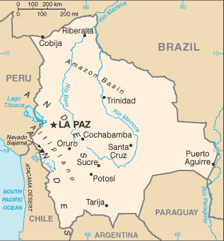 |
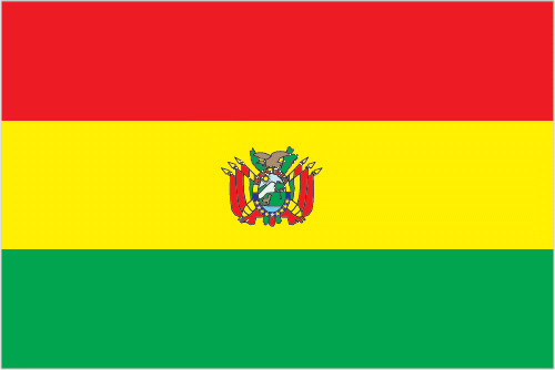
| The national flag of Bolivia | Borderline map of Bolivia |
| Flag description: three equal horizontal bands of red (top), yellow, and green with the coat of arms centered on the yellow band; red stands for bravery and the blood of national heroes, yellow for the nation’s mineral resources, and green for the fertility of the land. Note: similar to the flag of Ghana, which has a large black five-pointed star centered in the yellow band; in 2009, a presidential decree made it mandatory for a so-called wiphala – a square, a multi-colored flag representing the country’s indigenous peoples – to be used alongside the traditional flag. | Border length: total: 7,252 km. Border countries (total: 5): Argentina 942 km, Brazil 3,403 km, Chile 942 km, Paraguay 753 km, Peru 1,212 km. |
About La Paz
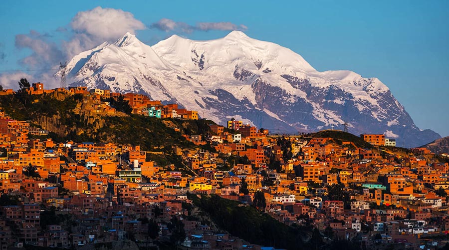
The city of La Paz is nestled in a valley atop the Bolivian plateau, surrounded by snowy peaks and dominated by the white head of Illimani, the sacred mountain. The setting is sure to take your breath away (and if the setting doesn’t, the 3,739m/12,264- ft. altitude will), but that’s not what I love best about La Paz. The Paceños themselves, the city’s inhabitants, are what make this place unforgettable. No other major South American city holds on to its past so firmly. Many of the women wear traditional clothing every day: colorful multilayered petticoats, fringed shawls, lace aprons, and (oddest of all) bowler hats, which look as if they came straight from a prewar London haberdashery. You’ll see these women throughout the city—on the buses, in the churches, shopping, or perhaps setting up their shops.
They probably won’t be setting up shop inside, though—hardly anyone does in La Paz. The city is one giant street market. Installs on the sidewalks or at street corners, you can buy not only batteries and chewing gum, but also dice and leather dice-cups, socks, hats, sneakers, cameras, and telephones. In the Mercado Negro (Black Market) area of the city, computers, electric drills, bookcases, office supplies, and everything else you could think of are all displayed on the sidewalk. At the Mercado de los Brujos (Witch Doctors’ Market), the discerning shopper can find the finest in good-luck statuettes and all the materials required for a proper offering to Pachamama, the Earth Mother, including baskets of dried llama fetuses. Perhaps you aren’t in the market for such things, but just being in a place where people are is half the fun of La Paz.
About Sucre
During Bolivia’s glory days, when Sucre – or, as it was known then, Chuquisaca – existed solely to administer the silver mines in nearby Potosí, the wealthy locals here would often brag, “My mines are in Potosí, but I live in Chuquisaca.” For those who could afford it, it made sense to live 162km (100 miles) down the road from Potosí in the relative lowlands (2,706m/8,876 ft.) of Sucre, which blessed with a mild climate and a much cheerier disposition. Gradually, Sucre became a city of understated prestige. It’s been called the Paris of South America because the wealth here attracted some of the most beautiful arts and culture from all over the world. It’s also been known as the Athens of South America because it’s home to the continent’s second-oldest and most prestigious university, San Francisco Xavier University, which dates to 1624 and has educated presidents of Argentina, Paraguay, Chile, Uruguay, and, of course, Bolivia. (Today, out of total pop. of about 200,000, over 30,000 are students, many of them studying medicine or law.)
For a city like Sucre, money, prestige, and knowledge weren’t enough. It also had to have a place in the history books. In 1825, some of the most famous South American revolutionaries converged upon the city and signed the country’s declaration of independence. Sucre then became the capital of the new republic.
These days, Sucre is the capital of Bolivia in name only—both the executive and legislative branches of the government left long ago for La Paz. The silver in nearby Potosí has pretty much run out, and the high culture has returned to Paris. Nevertheless, the city remains one of the most unusual and exciting places in Bolivia. Visitors can sit in the room where the Bolivian declaration of independence was signed, tour churches and museums that still have impressive collections of colonial art, and view the dinosaur tracks that archaeologists recently discovered right in Sucre’s backyard.
Did you know about Bolivia?
- Bolivia, originally known as Upper Peru, was named after Simón Bolívar who supervised its secession from Spain in 1825.
- Between 1825 and 1982 Bolivia averaged more than one armed coup a year.
- Landlocked Bolivia has the worlds highest capital city, golf course, ski run, and soccer stadium. About 70 percent of the people are Quechua or Aymara Amerindians, while the rest are European descendants or of mixed race.
Bolivia is one of only two South American countries to be surrounded by land on all sides. The dominant topographical feature is the Andes mountain chain. This forms two main ranges, the Cordillera Occidental and the Cordillera Oriental running from north to south in the southwestern third of the country. Between them is a high, treeless plateau called the Altiplano, which is where most Bolivians live. Lake Titicaca, which straddles the border with Peru, is in the northern part of the Altiplano. The lower, eastern slopes of the mountains form a region of forested, fertile valleys called the Yungas.
This gives way to an extensive, low-lying tropical region that comprises about 70 percent of the total land area. In the southeastern corner of this region, separated from the rest of the region by the Chiquitos Highlands, are the arid plains known as the Chaco. Farther north there are hot savannah lands or Llanos and dense tropical jungles blanketing the river valleys that traverse the region. Much of the land becomes swamp during the rainy season, but the higher grasslands are not affected. Most people live in rural areas and are engaged in fairly basic agriculture. Until quite recently, Bolivia’s leading product was tin, but natural gas is now of much greater importance to the Bolivian economy along with timber, soya beans, and sugar.
Facts of Bolivia (BO)
Name conventional long form: Plurinational State of Bolivia, conventional short form: Bolivia, local long form: Estado Plurinacional de Bolivia, local short form: Bolivia, etymology: the country named after Simon BOLIVAR, a 19th-century leader in the South American wars for independence
Codes: ISO; BO, Internet; .bo
Capital city: Sucre
Language(s): Spanish (official language) 60.7%, Quechua (official language) 21.2%, Aymara (official language) 14.6%, foreign languages 2.4%, Guarani (official language) 0.6%, other native languages 0.4%, none 0.1%. Note: Bolivia’s 2009 constitution designates Spanish, and all indigenous languages as official language; 36 indigenous languages are specified, including some that are extinct (2001 estimate)
National holiday(s): Independence Day, 6 August (1825)
Motto: La unión es la fuerza (Unity is Strength)
Currency: Bolivian boliviano (BOB), since 1986
GPS: 17 00 S, 65 00 W, Sucre; 16 30 S 68 09 W
Location: Central South America, southwest of Brazil
Geography note: landlocked country; shares control of Lago Titicaca, world’s highest navigable lake (elevation 3,805 m), with Peru
Land boundaries: Argentina 942 km, Brazil 3,403 km, Chile 942 km, Paraguay 753 km, Peru 1,212 km, total: 7,252 km
Maritime boundaries: N/A
Coastline: 0 km (landlocked country)
Area: total: 1,098,581 sq km; land: 1,083,301 sq km, water: 15,280 sq km (total 424 163,94 mi2), slightly less than three times the size of Montana.
Roadways: total: 80,488 km, paved: 6,850 km, unpaved: 73,638 km (2010)
Waterways: 10,000 km (commercially navigable almost exclusively in the northern and eastern parts of the country) (2012)
Local time (capital): UTC-4, 1 hour ahead of Washington DC during Standard Time
Note to the local time: N/A
Population in Bolivia: 11 215 674
Population in La Paz: 204 200 (including the metropolitan areas)
Urbanization: urban population: 68.5% of total population (2015)
Major urban areas population: Santa Cruz 2.107 million; LA PAZ (capital) 1.816 million; Cochabamba 1.24 million; Sucre (constitutional capital) 372,000 (2015)
Population growth rate: 1.54% (2016 estimate)
Birth rate: 22.4 births / 1,000 population (2016 estimate)
Death rate: 6.5 deaths / 1,000 population (2016 estimate)
Age structure: 0-14 years: 32.36% (male 1,808,567 / female 1,740,760) 15-24 years: 19.55% (male 1,086,134 / female 1,058,584) 25-54 years: 37.08% (male 1,986,514 / female 2,081,415) 55-64 years: 5.83% (male 296,197 / female 343,394) 65 years and over: 5.18% (male 250,749 / female 317,335) (2016 estimate)
Median age: total: 24 years; male: 23.3 years, female: 24.7 years (2016 estimate)
Ethnic groups: mestizo (mixed white and Amerindian ancestry) 68%, indigenous 20%, white 5%, cholo/chola 2%, black 1%, other 1%, unspecified 3% ; 44% of respondents indicated feeling part of some indigenous group, predominantly Quechua or Aymara. Note: results among surveys vary based on the wording of the ethnicity question and the available response choices; the 2001 national census did not provide “mestizo” as a response choice, resulting in a much higher proportion of respondents identifying themselves as belonging to one of the available indigenous ethnicity choices; the use of “mestizo” and “cholo” varies among response choices in surveys, with surveys using the terms interchangeably, providing one or the other as a response choice, or providing the two as separate response choices (2009 estimate)
Religions: Roman Catholic 76.8%, Evangelical and Pentecostal 8.1%, Protestant 7.9%, other 1.7%, none 5.5% (2012 estimate)
Government type: Unitary presidential constitutional republic
Legal system: civil law system with influences from Roman, Spanish, canon (religious), French, and indigenous law
National anthem: Himno Nacional de Bolivia
Known national hazards: flooding in the northeast (March to April)volcanism: volcanic activity in Andes Mountains on the border with Chile; historically active volcanoes in this region are Irruputuncu (elev. 5,163 m), which last erupted in 1995, and Olca-Paruma
Major infectious diseases: The The degree of risk(s): very high food or waterborne diseases: bacterial diarrhea and hepatitis A vectorborne diseases: dengue fever, malaria, and yellow fever. Note: active local transmission of Zika virus by Aedes species mosquitoes has been identified in this country (as of August 2016); it poses an important risk (a large number of cases possible) among US citizens if bitten by an infective mosquito; other less common ways to get Zika are through sex, via blood transfusion, or during pregnancy, in which the pregnant woman passes Zika virus to her fetus (2016)
Land use: agricultural land: 34.3%; arable land 3.6%; permanent crops 0.2%; permanent pasture 30.5%; forest: 52.5%; other: 13.2% (2011 estimate)
Agricultural products: soybeans, quinoa, Brazil nuts, sugarcane, coffee, corn, rice, potatoes, chia, coca
Industries: mining, smelting, petroleum, food and beverages, tobacco, handicrafts, clothing, jewelry
Export commodities: natural gas, mineral ores, gold, soybeans and soy products, tin
Main export partners: Brazil 28.1%, Argentina 16.9%, US 12.1%, Colombia 6.3%, China 5.3%, Japan 4.7%, South Korea 4.3% (2015)
Import commodities: machinery, petroleum products, vehicles, iron and steel, plastics
Main import partners: China 17.9%, Brazil 16.5%, Argentina 11.8%, US 10.6%, Peru 6.2%, Japan 5.2%, Chile 4.6% (2015)
Navigate the countries in South America faster and easier while driving, use the interactive Google maps for your driving directions. The continuously updated database contains over 220 countries and territories digitally mapped, hundreds of millions of businesses and places around the world positioned on the map.
Get fresh GPS navigation, traffic, and transit information – no matter what part of Bolivia, Sucre, any other city and country in America, or the world you’re in.
Do you like this Bolivia information page? Please don’t forget to share it with others! Thank you.