Cote d’Ivoire Google maps and Driving Directions
Get free driving directions, Google maps, traffic information for Cote d’Ivoire, and Yamoussoukro (GPS: 6 49 N 5 16 W), the capital city of the country located in (the) Western Africa, bordering the North Atlantic Ocean, between Ghana and Liberia.
Find any address in Yamoussoukro on the Google map of Cote d’Ivoire (CI) with ease or calculate your up to date itinerary to and from Cote d’Ivoire or its neighboring counties like Burkina Faso, Ghana, Guinea, Liberia, Mali.
Sightseeing and exploring in Africa starts here, thanks to Google because its Earth Engine combines a multi-petabyte catalog of updated satellite imagery and geospatial datasets with planetary-scale analysis capabilities. Wonder the world, use the satellite map function of the Google maps to explore or see differences on the Earth’s surface, inland, or the surrounding areas of Cote d’Ivoire.
Google Maps Cote d’Ivoire
One of the larger nations along the coast of west Africa, Côte d’Ivoire is the world’s biggest cocoa producer. An image of stability was rocked by civil war in 2002-2005.
Cote d’Ivoire is mostly flat to undulating plains; mountains in northwest.
The map above fully covers Cote d’Ivoire with its road routes from cities to towns, road intersections in any region, provinces, prefectures, also with free driving directions in Yamoussoukro or to the neighboring towns and countries. To look at the detailed map about a particular quarter in Yamoussoukro, please click on the area and zoom to the place you are interested in the Google maps of Cote d’Ivoire (CI).
Be creative, use the extras of this Google map; This is a detailed, clear, zoomable, large road map of Cote d’Ivoire with its administrative divisions; 12 districts and 2 autonomous districts*; Abidjan*, Bas-Sassandra, Comoe, Denguele, Goh-Djiboua, Lacs, Lagunes, Montagnes, Sassandra-Marahoue, Savanes, Vallee du Bandama, Woroba, Yamoussoukro*, Zanzan.
The interactive map above is also may be used as the satellite map of Cote d’Ivoire, or as a reverse search map for finding an address from its GPS coordinates.
Côte d’Ivoire (also known as the Ivory Coast), in western Africa on the Gulf of Guinea, is a little larger than New Mexico. Its neighbors are Liberia, Guinea, Mali, Burkina Faso, and Ghana. The country consists of a coastal strip in the south, dense forests in the interior, and savannas in the north.
Ivory Coast (area: 322 463 sq km / 124 503,61 sq mi), where the official language is French, lying in Africa and using the currency; West African CFA franc (XOF), set their clock to UTC 0. That means they are 5 hours ahead of Washington DC during Standard Time in Yamoussoukro, the capital. Note to the time difference: time difference: UTC 0 (5 hours ahead of Washington DC).
The climate in Cote d’Ivoire; High temperatures all year round. South has two wet seasons; north has one, with lower rainfall.
Geography in a nutshell; Sandy coastal strip backed by a largely rainforested interior, and a savanna plateau in the north.
Click here for more detailed information about Cote d’Ivoire.
Driving directions Cote d’Ivoire
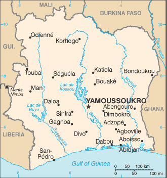
The Google maps and Google Satellite maps of Cote d’Ivoire above showing the country, located next to Burkina Faso, Ghana, Guinea, Liberia, Mali. For your further reference, the latitude and longitude coordinates of Cote d’Ivoire are 8 00 N, 5 00 W , while the capital, Yamoussoukro found at 6 49 N 5 16 W.
When you are traveling around Cote d’Ivoire, Yamoussoukro, or its other cities, use this routing tool, providing up to date route planning service free of charge.
Look no further; get accurate driving directions in Cote d’Ivoire, Africa, by filling the route planner form below.
Since Google acquired and introduced its digitalized maps in 2004, you’re probably familiar with its base functions, like finding an address or driving directions to locations. Still, Google maps also accommodate bicyclists, pedestrians, and also public transportation with special directions and customizable routes.
About Cote d’Ivoire and the capital, Yamoussoukro
 |
 |
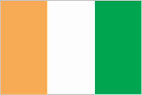
| The national flag of Cote d’Ivoire | Borderline map of Cote d’Ivoire |
| Flag description: three equal vertical bands of orange (hoist side), white, and green; orange symbolizes the land (savannah) of the north and fertility, white stands for peace and unity, green represents the forests of the south and the hope for a bright future. Note: similar to the flag of Ireland, which is longer and has the colors reversed – green (hoist side), white, and orange; also similar to the flag of Italy, which is green (hoist side), white, and red; design was based on the flag of France. | Border length: total: 3,458 km. Border countries (total: 5): Burkina Faso 545 km, Ghana 720 km, Guinea 816 km, Liberia 778 km, Mali 599 km. |
Did you know about Cote d’Ivoire?
- Ivory Coast was originally part of French West Africa. It became independent in its own right on August 7, 1960.
- The Basilica of Our Lady of Peace in Yamoussoukro is the largest church in the world.
- The worlds biggest producer of cocoa, the Ivory Coast also exports coffee and timber.
Facts of Cote d’Ivoire (CI)
Name conventional long form: Republic of Cote d’Ivoire, conventional short form: Cote d’Ivoire, local long form: Republique de Cote d’Ivoire, local short form: Cote d’Ivoire. Note: pronounced coat-div-whar, former: Ivory Coast, etymology: name reflects the intense ivory trade that took place in the region from the 15th to 17th centuries
Codes: ISO; CI, Internet; .ci
Capital city: Yamoussoukro
Language(s): French (official language), 60 native dialects of which Dioula is the most widely spoken
National holiday(s): Independence Day, 7 August (1960)
Motto: Union, Discipline, Travail (Unity, Discipline, Work)
Currency: West African CFA franc (XOF)
GPS: 8 00 N, 5 00 W, Yamoussoukro; 6 49 N 5 16 W
Location: Western Africa, bordering the North Atlantic Ocean, between Ghana and Liberia
Geography note: most of the inhabitants live along the sandy coastal region; apart from the capital area, the forested interior is sparsely populated
Land boundaries: Burkina Faso 545 km, Ghana 720 km, Guinea 816 km, Liberia 778 km, Mali 599 km, total: 3,458 km
Maritime boundaries: N/A
Coastline: 515 km
Area: total: 322,463 sq km; land: 318,003 sq km, water: 4,460 sq km (total 124 503,61 mi2), slightly larger than New Mexico.
Roadways: total: 81,996 km, paved: 6,502 km, unpaved: 75,494 km, note: includes intercity and urban roads; another 20,000 km of dirt roads are in poor condition and 150,000 km of dirt roads are impassable (2007)
Waterways: 980 km (navigable rivers, canals, and numerous coastal lagoons) (2011)
Local time (capital): UTC 0, 5 hours ahead of Washington DC during Standard Time
Note to the local time: time difference: UTC 0 (5 hours ahead of Washington DC)
Population in Cote d’Ivoire: 24 905 843
Population in Yamoussoukro: 937 700 (including the metropolitan areas)
Urbanization: urban population: 54.2% of total population (2015)
Major urban areas population: YAMOUSSOUKRO (capital) 259,000 (2014); ABIDJAN (seat of government) 4.86 million; Bouake 762,000 (2015)
Population growth rate: 1.88% (2016 estimate)
Birth rate: 28.2 births / 1,000 population (2016 estimate)
Death rate: 9.5 deaths / 1,000 population (2016 estimate)
Age structure: 0-14 years: 37.45% (male 4,483,215 / female 4,407,595) 15-24 years: 20.93% (male 2,504,188 / female 2,463,970) 25-54 years: 34.05% (male 4,133,975 / female 3,950,734) 55-64 years: 4.15% (male 493,722 / female 491,230) 65 years and over: 3.42% (male 389,551 / female 422,244) (2016 estimate)
Median age: total: 20.7 years; male: 20.8 years, female: 20.6 years (2016 estimate)
Ethnic groups: Akan 32.1%, Voltaique or Gur 15%, Northern Mande 12.4%, Krou 9.8%, Southern Mande 9%, other 21.2% (includes European and Lebanese descent), unspecified 0.5% (2011-12 estimate)
Religions: Muslim 40.2%, Catholic 19.4%, Evangelical 19.3%, Methodist 2.5%, other Christian 4.5%, animist or no religion 12.8%, other religion/unspecified 1.4% (2011-12 estimate). Note: the majority of foreign migrant workers are Muslim (72%) and Christian (18%) (2014 estimate)
Government type: Unitary presidential republic
Legal system: civil law system based on the French civil code; judicial review of legislation held in the Constitutional Chamber of the Supreme Court
National anthem: L’Abidjanaise
Known national hazards: coast has heavy surf and no natural harbors; during the rainy season torrential flooding is possible
Major infectious diseases: The degree of risk(s): very high food or waterborne diseases: bacterial diarrhea, hepatitis A, and typhoid fever vectorborne diseases: malaria, dengue fever, and yellow feverwater contact disease: schistosomiasis animal contact disease: rabiesrespiratory disease: meningococcal meningitis (2016)
Land use: agricultural land: 64.8%; arable land 9.1%; permanent crops 14.2%; permanent pasture 41.5%; forest: 32.7%; other: 2.5% (2011 estimate)
Agricultural products: coffee, cocoa beans, bananas, palm kernels, corn, rice, cassava (manioc, tapioca), sweet potatoes, sugar, cotton, rubber; timber
Industries: foodstuffs, beverages; wood products, oil refining, gold mining, truck and bus assembly, textiles, fertilizer, building materials, electricity
Export commodities: cocoa, coffee, timber, petroleum, cotton, bananas, pineapples, palm oil, fish
Main export partners: US 8.5%, Netherlands 6.2%, France 5.6%, Germany 5.6%, Nigeria 5.5%, Burkina Faso 5.5%, Belgium 5.3%, India 4.6%, Ghana 4.4%, Switzerland 4.1% (2015)
Import commodities: fuel, capital equipment, foodstuffs
Main import partners: Nigeria 21.9%, China 14.4%, France 11.4%, Bahamas, The 5% (2015)
Navigate the countries in Africa faster and easier while driving, use the interactive Google maps for your driving directions. The continuously updated database contains over 220 countries and territories digitally mapped, hundreds of millions of businesses and places around the world positioned on the map.
Get fresh GPS navigation, traffic, and transit information – no matter what part of Cote d’Ivoire, Yamoussoukro, any other city and country in Africa, or the world you’re in.
Do you like this Cote d’Ivoire information page? Please don’t forget to share it with others! Thank you.