Sudan Google maps and Driving Directions
Get free driving directions, Google maps, traffic information for Sudan, and Khartoum (GPS: 15 36 N 32 32 E), the capital city of the country located in (the) north-eastern Africa, bordering the Red Sea, between Egypt and Eritrea.
Find any address in Khartoum on the Google map of Sudan (SD) with ease or calculate your up to date itinerary to and from Sudan or its neighboring counties like Central African Republic, Chad, Egypt, Eritrea, Ethiopia, Libya, South Sudan.
Sightseeing and exploring in Africa starts here, thanks to Google because its Earth Engine combines a multi-petabyte catalog of updated satellite imagery and geospatial datasets with planetary-scale analysis capabilities. Wonder the world, use the satellite map function of the Google maps to explore or see differences on the Earth’s surface, inland, or the surrounding areas of Sudan.
Google Maps Sudan
The largest country in Africa, Sudan has undergone two civil wars between its Arab north and black African south. Darfur in the west now endures a terrible humanitarian crisis.
Sudan is generally flat, featureless plain; desert dominates the north.
The map above fully covers Sudan with its road routes from cities to towns, road intersections in any region, provinces, prefectures, also with free driving directions in Khartoum or to the neighboring towns and countries. To look at the detailed map about a particular quarter in Khartoun, please click on the area and zoom to the place you are interested in the Google maps of Sudan (SD).
Be creative, use the extras of this Google map; This is a detailed, clear, zoomable, large road map of Sudan with its administrative divisions; 18 states (wilayat, singular – wilayah); Blue Nile, Central Darfur, East Darfur, Gedaref, Gezira, Kassala, Khartoum, North Darfur, North Kordofan, Northern, Red Sea, River Nile, Sennar, South Darfur, South Kordofan, West Darfur, West Kordofan, White Nile.
The interactive map above is also may be used as the satellite map of Sudan, or as a reverse search map for finding an address from its GPS coordinates.
Sudan, in northeast Africa, measures about one-fourth the size of the United States. Its neighbors are Chad and the Central African Republic on the west, Egypt and Libya on the north, Ethiopia and Eritrea on the east, and South Sudan, Kenya, Uganda, and Democratic Republic of the Congo on the south. The Red Sea washes about 500 mi of the eastern coast. It is traversed from north to south by the Nile, all of whose great tributaries are partly or entirely within its borders.
Sudan (area: 1 861 480 sq km / 718 721,15 sq mi), where the official language is Arabic, English, lying in Africa and using the currency; Sudanese pound (SDG), since 2007, set their clock to UTC+3. That means they are 8 hours ahead of Washington DC during Standard Time in Khartoun, the capital. Note to the time difference: N/A.
The climate in Sudan; North is hot, arid desert with constant dry winds. Rainy season ranging from two months in the center to eight in the south.
Geography in a nutshell; Lies within the upper Nile basin. Mostly arid plains, with marshes in the south. Highlands border the Red Sea in the northeast.
Click here for more detailed information about Sudan.
Driving directions Sudan
The Google maps and Google Satellite maps of Sudan above showing the country, located next to Central African Republic, Chad, Egypt, Eritrea, Ethiopia, Libya, South Sudan. For your further reference, the latitude and longitude coordinates of Sudan are 15 00 N, 30 00 E , while the capital, Khartoun found at 15 36 N 32 32 E.
When you are traveling around Sudan, Khartoun, or its other cities, use this routing tool, providing up to date route planning service free of charge.
Look no further; get accurate driving directions in Sudan, Africa, by filling the route planner form below.
Since Google acquired and introduced its digitalized maps in 2004, you’re probably familiar with its base functions, like finding an address or driving directions to locations. Still, Google maps also accommodate bicyclists, pedestrians, and also public transportation with special directions and customizable routes.
About Sudan and the capital, Khartoum
 |
 |
| The national flag of Sudan | Borderline map of Sudan |
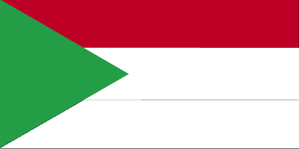
| Flag description: three equal horizontal bands of red (top), white, and black with a green isosceles triangle based on the hoist side; colors and design based on the Arab Revolt flag of World War I, but the meanings of the colors are expressed as follows: red signifies the struggle for freedom, white is the color of peace, light, and love, black represents the people of Sudan (in Arabic ‘Sudan’ means black), green is the color of Islam, agriculture, and prosperity. | Border length: total: 6,819 km. Border countries (total: 7): Central African Republic 174 km, Chad 1,403 km, Egypt 1,276 km, Eritrea 682 km, Ethiopia 744 km, Libya 382 km, South Sudan 2,158 km. Note: Sudan-South Sudan boundary represents 1 January 1956 alignment; final alignment pending negotiations and demarcation; final sovereignty status of Abyei region pending negotiations between Sudan and South Sudan. |
Did you know about Sudan?
- Ruled jointly by Egypt and Britain from 1877, Sudan became independent in 1956. Since then it has had a series of different regimes.
- Sudans Sudd is theworlds largest swamp.
- Khartoum, Sudans capital, sits on the banks of the Nile where its two tributaries meet.
Facts of Sudan (SD)
Name conventional long form: Republic of the Sudan, conventional short form: Sudan, local long form: Jumhuriyat as-Sudan, local short form: As-Sudan, former: Anglo-Egyptian Sudan, etymology: the name “Sudan” derives from the Arabic “bilad-as-sudan” meaning “Land of the black [peoples]”
Codes: ISO; SD, Internet; .sd
Capital city: Khartoum
Language(s): Arabic (official language), English (official language), Nubian, Ta Bedawie, Fur
National holiday(s): Independence Day, 1 January (1956)
Motto: An-nasr lana (Victory is ours)
Currency: Sudanese pound (SDG), since 2007
GPS: 15 00 N, 30 00 E, Khartoum; 15 36 N 32 32 E
Location: north-eastern Africa, bordering the Red Sea, between Egypt and Eritrea
Geography note: dominated by the Nile and its tributaries
Land boundaries: Central African Republic 174 km, Chad 1,403 km, Egypt 1,276 km, Eritrea 682 km, Ethiopia 744 km, Libya 382 km, South Sudan 2,158 km. Note: Sudan-South Sudan boundary represents 1 January 1956 alignment, total: 6,819 km
Maritime boundaries: N/A
Coastline: 853 km
Area: total: 1,861,484 sq km; land: NAwater: NA (total 718 721,15 mi2), slightly less than one-fifth the size of the US.
Roadways: total: 11,900 km, paved: 4,320 km, unpaved: 7,580 km (2000)
Waterways: 4,068 km (1,723 km open year round on White and Blue Nile Rivers) (2011)
Local time (capital): UTC+3, 8 hours ahead of Washington DC during Standard Time
Note to the local time: N/A
Population in Sudan: 41 511 526
Population in Khartoun: 4 632 000 (including the metropolitan areas)
Urbanization: urban population: 33.8% of total population (2015)
Major urban areas population: KHARTOUM (capital) 5.129 million (2015)
Population growth rate: 1.69% (2016 estimate)
Birth rate: 28.5 births / 1,000 population (2016 estimate)
Death rate: 7.5 deaths / 1,000 population (2016 estimate)
Age structure: 0-14 years: 39.43% (male 7,351,759 / female 7,130,224) 15-24 years: 20.77% (male 3,926,374 / female 3,703,826) 25-54 years: 32.42% (male 5,779,482 / female 6,129,213) 55-64 years: 4.12% (male 793,848 / female 721,075) 65 years and over: 3.25% (male 645,876 / female 547,824) (2016 estimate)
Median age: total: 19.6 years; male: 19.4 years, female: 19.9 years (2016 estimate)
Ethnic groups: Sudanese Arab (approximately 70%), Fur, Beja, Nuba, Fallata
Religions: Sunni Muslim, small Christian minority
Government type: Federal semi-presidential republic
Legal system: mixed legal system of Islamic law and English common law
National anthem: Nahnu Djundulla Djundulwatan (We are the Soldiers of God, the Soldiers of the Nation)
Known national hazards: dust storms and periodic persistent droughts
Major infectious diseases: The degree of risk(s): very high food or waterborne diseases: bacterial and protozoal diarrhea, hepatitis A and E, and typhoid fever vectorborne diseases: malaria, dengue fever, and Rift Valley feverwater contact disease: schistosomiasisrespiratory disease: meningococcal meningitisanimal contact disease: rabies (2016)
Land use: agricultural land: 100%; arable land 15.7%; permanent crops 0.2%; permanent pasture 84.2%; forest: 0%; other: 0% (2011 estimate)
Agricultural products: cotton, groundnuts (peanuts), sorghum, millet, wheat, gum Arabic, sugarcane, cassava (manioc, tapioca), mangoes, papaya, bananas, sweet potatoes, sesame seeds; animal feed, sheep and other livestock
Industries: oil, cotton ginning, textiles, cement, edible oils, sugar, soap distilling, shoes, petroleum refining, pharmaceuticals, armaments, automobile/light truck assembly, milling
Export commodities: gold; oil and petroleum products; cotton, sesame, livestock, peanuts, gum Arabic, sugar
Main export partners: UAE 32%, China 16.2%, Saudi Arabia 15.5%, Australia 4.7%, India 4.2% (2015)
Import commodities: foodstuffs, manufactured goods, refinery and transport equipment, medicines, chemicals, textiles, wheat
Main import partners: China 26.4%, UAE 10.1%, India 9.1%, Egypt 5.6%, Turkey 4.7%, Saudi Arabia 4.4% (2015)
Navigate the countries in Africa faster and easier while driving, use the interactive Google maps for your driving directions. The continuously updated database contains over 220 countries and territories digitally mapped, hundreds of millions of businesses and places around the world positioned on the map.
Get fresh GPS navigation, traffic, and transit information – no matter what part of Sudan, Khartoum, any other city and country in Africa, or the world you’re in.
Do you like this Sudan information page? Please don’t forget to share it with others! Thank you.