Turkmenistan Google maps and Driving Directions
Get free driving directions, Google maps, traffic information for Turkmenistan, and Ashgabat (GPS: 37 57 N 58 23 E), the capital city of the country located in (the) Central Asia, bordering the Caspian Sea, between Iran and Kazakhstan.
Find any address in Ashgabat on the Google map of Turkmenistan (TM) with ease or calculate your up to date itinerary to and from Turkmenistan or its neighboring counties like Afghanistan, Iran, Kazakhstan, Uzbekistan.
Sightseeing and exploring in Asia starts here, thanks to Google because its Earth Engine combines a multi-petabyte catalog of updated satellite imagery and geospatial datasets with planetary-scale analysis capabilities. Wonder the world, use the satellite map function of the Google maps to explore or see differences on the Earth’s surface, inland, or the surrounding areas of Turkmenistan.
Google Maps Turkmenistan
Stretching from the Caspian Sea into the central Asian desert, Turkmenistan has had less upheaval than most ex-Soviet states, but President Niyazov was a dictator.
Turkmenistan is flat-to-rolling sandy desert with dunes rising to mountains in the south; low mountains along border with Iran; borders Caspian Sea in west.
The map above fully covers Turkmenistan with its road routes from cities to towns, road intersections in any region, provinces, prefectures, also with free driving directions in Ashgabat or to the neighboring towns and countries. To look at the detailed map about a particular quarter in Ashgabat, please click on the area and zoom to the place you are interested in the Google maps of Turkmenistan (TM).
Be creative, use the extras of this Google map; This is a detailed, clear, zoomable, large road map of Turkmenistan with its administrative divisions; 5 provinces (welayatlar, singular – welayat) and 1 independent city*: Ahal Welayaty (Anew), Ashgabat*, Balkan Welayaty (Balkanabat), Dashoguz Welayaty, Lebap Welayaty (Turkmenabat), Mary Welayaty. Note: administrative divisions have the same names as their administrative centers (exceptions have the administrative center name following in parentheses).
The interactive map above is also may be used as the satellite map of Turkmenistan, or as a reverse search map for finding an address from its GPS coordinates.
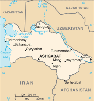
Turkmenistan (formerly Turkmenia) is bounded by the Caspian Sea in the west, Kazakhstan in the north, Uzbekistan in the east, and Iran and Afghanistan in the south. About nine-tenths of Turkmenistan is desert, chiefly the Kara-Kum. One of the world’s largest sand deserts, it is approximately 138,966 sq mi (360,000 sq km).
Turkmenistan (area: 488 100 sq km / 188 456,39 sq mi), where the official language is Russian, Turkmen, lying in Asia and using the currency; Turkmenistan manat (TMT), since 2009, set their clock to UTC+5. That means they are 10 hours ahead of Washington DC during Standard Time in Ashgabat, the capital. Note to the time difference: N/A.
The climate in Turkmenistan; Arid desert climate with extreme summer heat, but sub-freezing winter temperatures.
Geography in a nutshell; Low Garagum Desert covers 80% of the country. Mountains on southern border with Iran. Fertile Amu Darya Valley in north.
Click here for more detailed information about Turkmenistan.
Driving directions Turkmenistan
The Google maps and Google Satellite maps of Turkmenistan above showing the country, located next to Afghanistan, Iran, Kazakhstan, Uzbekistan. For your further reference, the latitude and longitude coordinates of Turkmenistan are 40 00 N, 60 00 E , while the capital, Ashgabat found at 37 57 N 58 23 E.
When you are traveling around Turkmenistan, Ashgabat, or its other cities, use this routing tool, providing up to date route planning service free of charge.
Look no further; get accurate driving directions in Turkmenistan, Asia, by filling the route planner form below.
[xyz-ihs snippet=”routing”]
Since Google acquired and introduced its digitalized maps in 2004, you’re probably familiar with its base functions, like finding an address or driving directions to locations. Still, Google maps also accommodate bicyclists, pedestrians, and also public transportation with special directions and customizable routes.
About Turkmenistan and the capital, Ashgabat
 |
 |
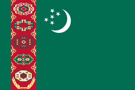
| The national flag of Turkmenistan | Borderline map of Turkmenistan |
| Flag description: green field with a vertical red stripe near the hoist side, containing five tribal guls (designs used in producing carpets) stacked above two crossed olive branches; five white stars and a white crescent moon appear in the upper corner of the field just to the fly side of the red stripe; the green color and crescent moon represent Islam; the five stars symbolize the regions or welayats of Turkmenistan; the guls reflect the national identity of Turkmenistan where carpet-making has long been a part of traditional nomadic life. Note: the flag of Turkmenistan is the most intricate of all national flags. | Border length: total: 4,158 km. Border countries (total: 4): Afghanistan 804 km, Iran 1,148 km, Kazakhstan 413 km, Uzbekistan 1,793 km. |
Did you know about Turkmenistan?
- Turkmenistan was originally one of the 15 federated states of the USSR. It broke away and became an independent republic in 1991.
- President Niyazov created an elaborate personality cult, styling himself as Turkmenbashi “head of all Turkmen.
- The “land of the Turkmen nomads is famous for its Akhal-Teke racehorses-the countrys national emblem.
Facts of Turkmenistan (TM)
Name conventional long form: none, conventional short form: Turkmenistan, local long form: none, local short form: Turkmenistan, former: Turkmen Soviet Socialist Republic, etymology: the suffix “-stan” means “place of” or “country,” so Turkmenistan literally means the “Land of the Turkmen [people]”
Codes: ISO; TM, Internet; .tm
Capital city: Ashgabat
Language(s): Turkmen (official language) 72%, Russian 12%, Uzbek 9%, other 7%
National holiday(s): Independence Day, 27 October (1991)
Motto: N/A
Currency: Turkmenistan manat (TMT), since 2009
GPS: 40 00 N, 60 00 E, Ashgabat; 37 57 N 58 23 E
Location: Central Asia, bordering the Caspian Sea, between Iran and Kazakhstan
Geography note: landlocked country; the western and central low-lying desolate portions of the country make up the great Garagum (Kara-Kum) desert, which occupies over 80% of the country; eastern part is plateau
Land boundaries: Afghanistan 804 km, Iran 1,148 km, Kazakhstan 413 km, Uzbekistan 1,793 km, total: 4,158 km
Maritime boundaries: Caspian Sea
Coastline: 0 km; note – Turkmenistan borders the Caspian Sea (1,768 km)
Area: total: 488,100 sq km; land: 469,930 sq km, water: 18,170 sq km (total 188 456,39 mi2), slightly larger than California.
Roadways: total: 58,592 km, paved: 47,577 km, unpaved: 11,015 km (2002)
Waterways: 1,300 km (Amu Darya and Kara Kum canal are important inland waterways) (2011)
Local time (capital): UTC+5, 10 hours ahead of Washington DC during Standard Time
Note to the local time: N/A
Population in Turkmenistan: 5 851 466
Population in Ashgabat: 683 000 (including the metropolitan areas)
Urbanization: urban population: 50% of total population (2015)
Major urban areas population: ASHGABAT (capital) 746,000 (2015)
Population growth rate: 1.13% (2016 estimate)
Birth rate: 19.3 births / 1,000 population (2016 estimate)
Death rate: 6.1 deaths / 1,000 population (2016 estimate)
Age structure: 0-14 years: 25.95% (male 695,752 / female 677,166) 15-24 years: 19.04% (male 506,856 / female 500,647) 25-54 years: 42.86% (male 1,125,058 / female 1,142,870) 55-64 years: 7.59% (male 189,464 / female 212,330) 65 years and over: 4.56% (male 105,140 / female 136,034) (2016 estimate)
Median age: total: 27.5 years; male: 27 years, female: 28 years (2016 estimate)
Ethnic groups: Turkmen 85%, Uzbek 5%, Russian 4%, other 6% (2003)
Religions: Muslim 89%, Eastern Orthodox 9%, unknown 2%
Government type: Presidential republic
Legal system: civil law system with Islamic law influences
National anthem: Garassyz, Bitarap, Türkmenistanyn Döwlet Gimni (State Anthem of Independent, Neutral Turkmenistan)
Known national hazards: N/A
Major infectious diseases: N/A
Land use: agricultural land: 72%; arable land 4.1%; permanent crops 0.1%; permanent pasture 67.8%; forest: 8.8%; other: 19.2% (2011 estimate)
Agricultural products: cotton, grain, melons; livestock
Industries: natural gas, oil, petroleum products, textiles, food processing
Export commodities: gas, crude oil, petrochemicals, textiles, cotton fiber
Main export partners: China 68.6%, Turkey 4.9% (2015)
Import commodities: machinery and equipment, chemicals, foodstuffs
Main import partners: Turkey 24.9%, Russia 12.3%, China 10.9%, UAE 9.1%, Kazakhstan 5.1%, Germany 4.6%, Iran 4.4% (2015)
Navigate the countries in Asia faster and easier while driving, use the interactive Google maps for your driving directions. The continuously updated database contains over 220 countries and territories digitally mapped, hundreds of millions of businesses and places around the world positioned on the map.
Get fresh GPS navigation, traffic, and transit information – no matter what part of Turkmenistan, Ashgabat, any other city and country in Asia, or the world you’re in.
Do you like this Turkmenistan information page? Please don’t forget to share it with others! Thank you.