Democratic Republic of the Congo Google maps and Driving Directions
Get free driving directions, Google maps, traffic information for Democratic Republic of the Congo, and Kinshasa (GPS: 4 19 S 15 18 E), the capital city of the country located in (the) Central Africa, northeast of Angola.
Find any address in Kinshasa on the Google map of Democratic Republic of the Congo (CG) with ease or calculate your up to date itinerary to and from Democratic Republic of the Congo or its neighboring counties like Angola, Angola, Burundi, Central African Republic, Republic of the Congo, Rwanda, South Sudan, Tanzania, Uganda, Zambia.
Sightseeing and exploring in Africa starts here, thanks to Google because its Earth Engine combines a multi-petabyte catalog of updated satellite imagery and geospatial datasets with planetary-scale analysis capabilities. Wonder the world, use the satellite map function of the Google maps to explore or see differences on the Earth’s surface, inland, or the surrounding areas of Democratic Republic of the Congo.
Google Maps Democratic Republic of the Congo
Lying in east-central Africa, the Democratic Republic of the Congo (DRC) is one of Africas largest countries, and the scene of one of its worst regional wars.
Democratic Republic of the Congo is vast central basin is a low-lying plateau; mountains in east.
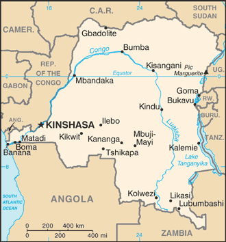
The map above fully covers Democratic Republic of the Congo with its road routes from cities to towns, road intersections in any region, provinces, prefectures, also with free driving directions in Kinshasa or to the neighboring towns and countries. To look at the detailed map about a particular quarter in Kinshasa, please click on the area and zoom to the place you are interested in the Google maps of Democratic Republic of the Congo (CG).
Be creative, use the extras of this Google map; This is a detailed, clear, zoomable, large road map of Democratic Republic of the Congo with its administrative divisions; 26 provinces (provinces, singular – province); Bas-Uele, Equateur, Haut-Katanga, Haut-Lomami, Haut-Uele, Ituri, Kasai, Kasai-Central, Kasai-Oriental (East Kasai), Kinshasa, Kongo Central, Kwango, Kwilu, Lomami, Lualaba, Mai-Ndombe, Maniema, Mongala, Nord-Kivu (North Kivu), Nord-Ubangi (North Ubangi), Sankuru, Sud-Kivu (South Kivu), Sud-Ubangi (South Ubangi), Tanganyika, Tshopo, Tshuapa.
The interactive map above is also may be used as the satellite map of Democratic Republic of the Congo, or as a reverse search map for finding an address from its GPS coordinates.
The Congo, in west-central Africa, is bordered by the Republic of Congo, the Central African Republic, the Sudan, Uganda, Rwanda, Burundi, Tanzania, Zambia, Angola, and the Atlantic Ocean. It is one-quarter the size of the U.S. The principal rivers are the Ubangi and Bomu in the north and the Congo in the west, which flows into the Atlantic. The entire length of Lake Tanganyika lies along the eastern border with Tanzania and Burundi.
Democratic Republic of Congo (area: 2 344 860 sq km / 905 355,14 sq mi), where the official language is French, lying in Africa and using the currency; Congolese franc (CDF), set their clock to UTC+1. That means they are 6 hours ahead of Washington DC during Standard Time in Kinshasa, the capital. Note to the time difference: N/A.
The climate in Democratic Republic of the Congo; Tropical and humid. Distinct wet and dry seasons south of the equator. The north is mainly wet.
Geography in a nutshell; Rainforested basin of Congo River occupies 60% of the land area. High mountain ranges and lakes stretch down the eastern border.
Click here for more detailed information about Democratic Republic of the Congo.
Driving directions Democratic Republic of the Congo
The Google maps and Google Satellite maps of Democratic Republic of the Congo above showing the country, located next to Angola, Angola, Burundi, Central African Republic, Republic of the Congo, Rwanda, South Sudan, Tanzania, Uganda, Zambia. For your further reference, the latitude and longitude coordinates of Democratic Republic of the Congo are 0 00 N, 25 00 E , while the capital, Kinshasa found at 4 19 S 15 18 E.
When you are traveling around Democratic Republic of the Congo, Kinshasa, or its other cities, use this routing tool, providing up to date route planning service free of charge.
Look no further; get accurate driving directions in Democratic Republic of the Congo, Africa, by filling the route planner form below.
Since Google acquired and introduced its digitalized maps in 2004, you’re probably familiar with its base functions, like finding an address or driving directions to locations. Still, Google maps also accommodate bicyclists, pedestrians, and also public transportation with special directions and customizable routes.
About Democratic Republic of the Congo and the capital, Kinshasa
 |
 |
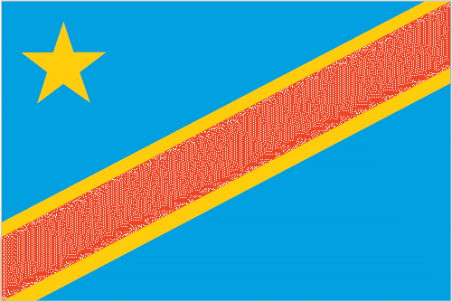
| The national flag of Democratic Republic of the Congo | Borderline map of Democratic Republic of the Congo |
| Flag description: sky blue field divided diagonally from the lower hoist corner to upper fly corner by a red stripe bordered by two narrow yellow stripes; a yellow, five-pointed star appears in the upper hoist corner; blue represents peace and hope, red the blood of the country’s martyrs, and yellow the country’s wealth and prosperity; the star symbolizes unity and the brilliant future for the country. | Border length: total: 10,481 km. Border countries (total: 9): Angola 2,646 km (of which 225 km is the boundary of Angola‘s discontiguous Cabinda Province), Burundi 236 km, Central African Republic 1,747 km, Republic of the Congo 1,229 km, Rwanda 221 km, South Sudan 714 km, Tanzania 479 km, Uganda 877 km, Zambia 2,332 km. |
Did you know about Democratic Republic of the Congo?
- The Democratic Republic of the Congo was originally the Congo Free State (1880). In 1908, it became the Belgian Congo and gained independence in 1960.
- The DRCs rainforests comprise 6% of the worlds, and 50% ofAfricas, remaining woodlands.
- This vast, tropical nation has massive mineral wealth, with large quantities of coltan, which is essential for the production of mobile phones.
Facts of Democratic Republic of the Congo (CG)
Name conventional long form: Democratic Republic of the Congo, conventional short form: DRC, local long form: Republique Democratique du Congo, local short form: RDC, former: Congo Free State, Belgian Congo, Congo/Leopoldville, Congo/Kinshasa, Zaireabbreviation: DRC, etymology: named for the Congo River, most of which lies within the DRC; the river name derives from Kongo, a Bantu kingdom that occupied its mouth at the time of Portuguese discovery in the late 15th century and whose name stems from its people the Bakongo, meaning “hunters”
Codes: ISO; CG, Internet; .cd
Capital city: Kinshasa
Language(s): French (official language), Lingala (a lingua franca trade language), Kingwana (a dialect of Kiswahili or Swahili), Kikongo, Tshiluba
National holiday(s): Independence Day, 30 June (1960)
Motto: Paix, Justice, Travail (Justice, Peace, Work)
Currency: Congolese franc (CDF)
GPS: 0 00 N, 25 00 E, Kinshasa; 4 19 S 15 18 E
Location: Central Africa, northeast of Angola
Geography note: second largest country in Africa (after Algeria) and largest country in Sub-Saharan Africa; straddles the equator; has narrow strip of land that controls the lower Congo River and is only outlet to South Atlantic Ocean; dense tropical rain forest in central river basin and eastern highlands
Land boundaries: Angola 2,646 km (of which 225 km is the boundary of Angola‘s discontiguous Cabinda Province), Burundi 236 km, Central African Republic 1,747 km, Republic of the Congo 1,229 km, Rwanda 221 km, South Sudan 714 km, Tanzania 479 km, Uganda 877 km, Zambia 2,332 km, total: 10,481 km
Maritime boundaries: N/A
Coastline: 37 km
Area: total: 2,344,858 sq km; land: 2,267,048 sq km, water: 77,810 sq km (total 905 355,14 mi2), slightly less than one-fourth the size of the US.
Roadways: total: 153,497 km, paved: 2,794 km, unpaved: 150,703 km (2004)
Waterways: 15,000 km (including the Congo, its tributaries, and unconnected lakes) (2011)
Local time (capital): UTC+1, 6 hours ahead of Washington DC during Standard Time
Note to the local time: N/A
Population in Democratic Republic of the Congo: 84 004 989
Population in Kinshasa: 1 169 900 (including the metropolitan areas)
Urbanization: urban population: 42.5% of total population (2015)
Major urban areas population: KINSHASA (capital) 11.587 million; Lubumbashi 2.015 million; Mbuji-Mayi 20.007 million; Kananga 1.169 million; Kisangani 1.04 million; Bukavu 832,000 (2015)
Population growth rate: 2.42% (2016 estimate)
Birth rate: 34.2 births / 1,000 population (2016 estimate)
Death rate: 9.9 deaths / 1,000 population (2016 estimate)
Age structure: 0-14 years: 42.2% (male 17,300,707 / female 17,024,082) 15-24 years: 21.44% (male 8,747,038 / female 8,694,000) 25-54 years: 30.13% (male 12,227,971 / female 12,273,304) 55-64 years: 3.58% (male 1,374,050 / female 1,535,973) 65 years and over: 2.65% (male 910,456 / female 1,243,469) (2016 estimate)
Median age: total: 18.4 years; male: 18.1 years, female: 18.6 years (2016 estimate)
Ethnic groups: over 200 African ethnic groups of which the majority are Bantu; the four largest tribes – Mongo, Luba, Kongo (all Bantu), and the Mangbetu-Azande (Hamitic) make up about 45% of the population
Religions: Roman Catholic 50%, Protestant 20%, Kimbanguist 10%, Muslim 10%, other (includes syncretic sects and indigenous beliefs) 10%
Government type: Unitary semi-presidential republic
Legal system: civil law system primarily based on Belgian law, but also customary, and tribal law
National anthem: Debout Congolais (Arise, Congolese)
Known national hazards: periodic droughts in south; Congo River floods (seasonal); active volcanoes in the east along the Great Rift Valleyvolcanism: Nyiragongo (elev. 3,470 m), which erupted in 2002 and is experiencing ongoing activity, poses a major threat to the city of Goma, home to a quarter million people; the volcano produces unusually fast-moving lava, known to travel up to 100 km /hr; Nyiragongo has been deemed a Decade Volcano by the International Association of Volcanology and Chemistry of the Earth’s Interior, worthy of study due to its explosive history and proximity to human populations; its neighbor, Nyamuragira, which erupted in 2010, is Africa’s most active volcano; Visoke is the only other historically active volcano
Major infectious diseases: The degree of risk(s): very high food or waterborne diseases: bacterial and protozoal diarrhea, hepatitis A, and typhoid fever vectorborne diseases: malaria, dengue fever, and trypanosomiasis-gambiense (African sleeping sickness)water contact disease: schistosomiasis animal contact disease: rabies (2016)
Land use: agricultural land: 11.4%; arable land 3.1%; permanent crops 0.3%; permanent pasture 8%; forest: 67.9%; other: 20.7% (2011 estimate)
Agricultural products: coffee, sugar, palm oil, rubber, tea, cotton, cocoa, quinine, cassava (manioc, tapioca), bananas, plantains, peanuts, root crops, corn, fruits; wood products
Industries: mining (copper, cobalt, gold, diamonds, coltan, zinc, tin, tungsten), mineral processing, consumer products (textiles, plastics, footwear, cigarettes), metal products, processed foods and beverages, timber, cement, commercial ship repair
Export commodities: diamonds, copper, gold, cobalt, wood products, crude oil, coffee
Main export partners: China 43.5%, Zambia 25%, South Korea 4.9%, Belgium 4.8% (2015)
Import commodities: foodstuffs, mining and other machinery, transport equipment, fuels
Main import partners: China 20.6%, South Africa 17.7%, Zambia 12.3%, Belgium 6.9%, Zimbabwe 5.1%, India 4.7% (2015)
Navigate the countries in Africa faster and easier while driving, use the interactive Google maps for your driving directions. The continuously updated database contains over 220 countries and territories digitally mapped, hundreds of millions of businesses and places around the world positioned on the map.
Get fresh GPS navigation, traffic, and transit information – no matter what part of Democratic Republic of the Congo, Kinshasa, any other city and country in Africa, or the world you’re in.
Do you like this Democratic Republic of the Congo information page? Please don’t forget to share it with others! Thank you.