South Sudan Google maps and Driving Directions
Get free driving directions, Google maps, traffic information for South Sudan, and Juba (GPS: 04 51 N 31 37 E), the capital city of the country located in (the) East-Central Africa; south of Sudan, north of Uganda and Kenya, west of Ethiopia.
Find any address in Juba on the Google map of South Sudan (SS) with ease or calculate your up to date itinerary to and from South Sudan or its neighboring counties like Central African Republic, Democratic Republic of Congo, Ethiopia, Kenya, Sudan, Uganda.
Sightseeing and exploring in Africa starts here, thanks to Google because its Earth Engine combines a multi-petabyte catalog of updated satellite imagery and geospatial datasets with planetary-scale analysis capabilities. Wonder the world, use the satellite map function of the Google maps to explore or see differences on the Earth’s surface, inland, or the surrounding areas of South Sudan.
Google Maps South Sudan
A long civil war in Sudan led to independence in 2011 for the mainly Christian southern part. The landlocked new stateis poor and lacks vital infrastructure, despite its oil reserves.
South Sudan is plains in the north and center rise to southern highlands along the border with Uganda and Kenya; the White Nile, flowing north out of the uplands of Central Africa, is the major geographic feature of the country; The Sudd (a name derived from floating vegetation that hinders navigation) is a large swampy area of more than 100,000 sq km fed by the waters of the White Nile that dominates the center of the country.
The map above fully covers South Sudan with its road routes from cities to towns, road intersections in any region, provinces, prefectures, also with free driving directions in Juba or to the neighboring towns and countries. To look at the detailed map about a particular quarter in Juba, please click on the area and zoom to the place you are interested in the Google maps of South Sudan (SS).
Be creative, use the extras of this Google map; This is a detailed, clear, zoomable, large road map of South Sudan with its administrative divisions; 10 states; Central Equatoria, Eastern Equatoria, Jonglei, Lakes, Northern Bahr el Ghazal, Unity, Upper Nile, Warrap, Western Bahr el Ghazal, Western Equatoria.
The interactive map above is also may be used as the satellite map of South Sudan, or as a reverse search map for finding an address from its GPS coordinates.
South Sudan is located in East-Central Africa south of Sudan, north of Uganda and Kenya, west of Ethiopia. Plains in the north and center rise to southern highlands along the border with Uganda and Kenya the White Nile, flowing north out of the uplands of Central Africa, is the major geographic feature of the country The Sudd (a name derived from floating vegetation that hinders navigation) is a large swampy area of more than 100,000 sq km fed by the waters of the White Nile that dominates the center of the country. South Sudan shares borders with six neighboring countries. In order of shared border length, these are: Sudan (2,158 km), Ethiopia (1,299 km), Central African Republic (1,055 km), Democratic Republic of the Congo (714 km), Uganda (475 km), and Kenya (317 km).
South Sudan (area: 619 745 sq km / 239 284,78 sq mi), where the official language is English, lying in Africa and using the currency; South Sudanese pound (SSP), since 2011, set their clock to UTC+3. That means they are 8 hours ahead of Washington DC during Standard Time in Juba, the capital. Note to the time difference: N/A.
The climate in South Sudan; Tropical South Sudan‘s long, heavy rains result in some areas getting cut off. January to March is drier.
Geography in a nutshell; The White Nile flows through South Sudan, from remote forest areas into the world’s largest swamp, the Sudd.
Click here for more detailed information about South Sudan.
Driving directions South Sudan
The Google maps and Google Satellite maps of South Sudan above showing the country, located next to Central African Republic, Democratic Republic of Congo, Ethiopia, Kenya, Sudan, Uganda. For your further reference, the latitude and longitude coordinates of South Sudan are 8 00 N, 30 00 E , while the capital, Juba found at 04 51 N 31 37 E.
When you are traveling around South Sudan, Juba, or its other cities, use this routing tool, providing up to date route planning service free of charge.
Look no further; get accurate driving directions in South Sudan, Africa, by filling the route planner form below.
Since Google acquired and introduced its digitalized maps in 2004, you’re probably familiar with its base functions, like finding an address or driving directions to locations. Still, Google maps also accommodate bicyclists, pedestrians, and also public transportation with special directions and customizable routes.
About South Sudan and the capital, Juba
 |
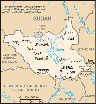 |
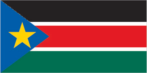
| The national flag of South Sudan | Borderline map of South Sudan |
| Flag description: three equal horizontal bands of black (top), red, and green; the red band is edged in white; a blue isosceles triangle based on the hoist side contains a gold, five-pointed star; black represents the people of South Sudan, red the bloodshed in the struggle for freedom, green the verdant land, and blue the waters of the Nile; the gold star represents the unity of the states making up South Sudan. Note: resembles the flag of Kenya; one of only two national flags to display six colors as part of its primary design, the other is South Africa‘s. | Border length: total: 6,018 km. Border countries (total: 6): Central African Republic 1,055 km, Democratic Republic of the Congo 714 km, Ethiopia 1,299 km, Kenya 317 km, Sudan 2,158 km, Uganda 475 km. Note: South Sudan–Sudan boundary represents 1 January 1956 alignment; final alignment pending negotiations and demarcation; final sovereignty status of Abyei Area pending negotiations between South Sudan and Sudan. |
Did you know about South Sudan?
- South Sudan officially known as the Republic of South Sudan, gained independence from the Republic of the Sudan in 2011, making it the most recent sovereign state with widespread recognition.
- Decades of fighting from 1983 left over four million internally displaced.
- South Sudan has a population of 12 million, mostly of the Nilotic peoples, and it is demographically among the youngest nations in the world, with roughly half under 18 years old.
Facts of South Sudan (SS)
Name conventional long form: Republic of South Sudan, conventional short form: South Sudan, etymology: self-descriptive name from the country’s former position within Sudan prior to independence; the name “Sudan” derives from the Arabic “bilad-as-sudan” meaning “Land of the black [peoples]”
Codes: ISO; SS, Internet; .ss
Capital city: Juba
Language(s): English (official language), Arabic (includes Juba and Sudanese variants), regional languages include Dinka, Nuer, Bari, Zande, Shilluk
National holiday(s): Independence Day, 9 July (2011)
Motto: Justice, Liberty, Prosperity (Justice, Liberty, Prosperity)
Currency: South Sudanese pound (SSP), since 2011
GPS: 8 00 N, 30 00 E, Juba; 04 51 N 31 37 E
Location: East-Central Africa; south of Sudan, north of Uganda and Kenya, west of Ethiopia
Geography note: The Sudd is a vast swamp in South Sudan, formed by the White Nile, comprising more than 15% of the country’s total area; it is one of the world’s largest wetlands
Land boundaries: Central African Republic 1,055 km, Democratic Republic of the Congo 714 km, Ethiopia 1,299 km, Kenya 317 km, Sudan 2,158 km, Uganda 475 km. Note: South Sudan–Sudan boundary represents 1 January 1956 alignment, total: 6,018 km
Maritime boundaries: N/A
Coastline: 0 km (landlocked country)
Area: total: 644,329 sq km; land: NAwater: NA (total 239 284,78 mi2), more than four times the size of Georgia; slightly smaller than Texas.
Roadways: total: 7,000 km, note: most of the road network is unpaved and much of it is in disrepair; a 192-km paved road between the capital, Juba, and Nimule on the Ugandan border was constructed with USAID funds in 2012 (2012)
Waterways: see entry for Sudan
Local time (capital): UTC+3, 8 hours ahead of Washington DC during Standard Time
Note to the local time: N/A
Population in South Sudan: 12 919 053
Population in Juba: 269 000 (including the metropolitan areas)
Urbanization: urban population: 18.8% of total population (2015)
Major urban areas population: JUBA (capital) 321,000 (2015)
Population growth rate: 3.92% (2016 estimate)
Birth rate: 36.2 births / 1,000 population (2016 estimate)
Death rate: 8 deaths / 1,000 population (2016 estimate)
Age structure: 0-14 years: 44.86% (male 2,866,374 / female 2,755,451) 15-24 years: 20.32% (male 1,338,548 / female 1,208,109) 25-54 years: 29.4% (male 1,783,091 / female 1,901,553) 55-64 years: 3.31% (male 222,760 / female 192,274) 65 years and over: 2.1% (male 145,687 / female 116,870) (2016 estimate)
Median age: total: 17.1 years; male: 17 years, female: 17.3 years (2016 estimate)
Ethnic groups: Dinka 35.8%, Nuer 15.6%, Shilluk, Azande, Bari, Kakwa, Kuku, Murle, Mandari, Didinga, Ndogo, Bviri, Lndi, Anuak, Bongo, Lango, Dungotona, Acholi (2011 estimate)
Religions: animist, Christian
Government type: Federal presidential constitutional republic
Legal system: N/A
National anthem: South Sudan Oyee! (South Sudan Hurray)
Known national hazards: N/A
Major infectious diseases: The degree of risk(s): very high food or waterborne disease: bacterial and protozoal diarrhea, hepatitis A and E, and typhoid fever vectorborne disease: malaria, dengue fever, trypanosomiasis-Gambiense (African sleeping sickness)water contact disease: schistosomiasisrespiratory disease: meningococcal meningitisanimal contact disease: rabies (2016)
Land use: N/A
Agricultural products: sorghum, maize, rice, millet, wheat, gum arabic, sugarcane, mangoes, papayas, bananas, sweet potatoes, sunflower seeds, cotton, sesame seeds, cassava (manioc, tapioca), beans, peanuts; cattle, sheep
Industries: N/A
Export commodities: N/A
Main export partners: N/A
Import commodities: N/A
Main import partners: N/A
Navigate the countries in Africa faster and easier while driving, use the interactive Google maps for your driving directions. The continuously updated database contains over 220 countries and territories digitally mapped, hundreds of millions of businesses and places around the world positioned on the map.
Get fresh GPS navigation, traffic, and transit information – no matter what part of South Sudan, Juba, any other city and country in Africa, or the world you’re in.
Do you like this South Sudan information page? Please don’t forget to share it with others! Thank you.