Kenya Google maps and Driving Directions
Get free driving directions, Google maps, traffic information for Kenya, and Nairobi (GPS: 1 17 S 36 49 E), the capital city of the country located in (the) Eastern Africa, bordering the Indian Ocean, between Somalia and Tanzania.
Find any address in Nairobi on the Google map of Kenya (KE) with ease or calculate your up to date itinerary to and from Kenya or its neighboring counties like Ethiopia, Somalia, South Sudan, Tanzania, Uganda.
Sightseeing and exploring in Africa starts here, thanks to Google because its Earth Engine combines a multi-petabyte catalog of updated satellite imagery and geospatial datasets with planetary-scale analysis capabilities. Wonder the world, use the satellite map function of the Google maps to explore or see differences on the Earth’s surface, inland, or the surrounding areas of Kenya.
Google Maps Kenya
Kenya straddles the equator on Africas east coast. After nearly 40 years in power, the KANU party was soundly defeated in elections in 2002. Corruption is a serious issue.
Kenya is low plains rise to central highlands bisected by Great Rift Valley; fertile plateau in west.
The map above fully covers Kenya with its road routes from cities to towns, road intersections in any region, provinces, prefectures, also with free driving directions in Nairobi or to the neighboring towns and countries. To look at the detailed map about a particular quarter in Nairobi, please click on the area and zoom to the place you are interested in the Google maps of Kenya (KE).
Be creative, use the extras of this Google map; This is a detailed, clear, zoomable, large road map of Kenya with its administrative divisions; 47 counties; Baringo, Bomet, Bungoma, Busia, Elgeyo/Marakwet, Embu, Garissa, Homa Bay, Isiolo, Kajiado, Kakamega, Kericho, Kiambu, Kilifi, Kirinyaga, Kisii, Kisumu, Kitui, Kwale, Laikipia, Lamu, Machakos, Makueni, Mandera, Marsabit, Meru, Migori, Mombasa, Murang’a, Nairobi City, Nakuru, Nandi, Narok, Nyamira, Nyandarua, Nyeri, Samburu, Siaya, Taita/Taveta, Tana River, Tharaka-Nithi, Trans Nzoia, Turkana, Uasin Gishu, Vihiga, Wajir, West Pokot.
The interactive map above is also may be used as the satellite map of Kenya, or as a reverse search map for finding an address from its GPS coordinates.
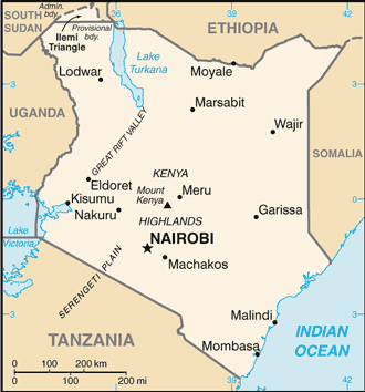
Kenya lies across the equator in east-central Africa, on the coast of the Indian Ocean. It is twice the size of Nevada. Kenya borders Somalia to the east, Ethiopia to the north, Tanzania to the south, Uganda to the west, and Sudan to the northwest. In the north, the land is arid the southwest corner is in the fertile Lake Victoria Basin and a length of the eastern depression of the Great Rift Valley separates western highlands from those that rise from the lowland coastal strip.
Kenya (area: 580 367 sq km / 224 080,86 sq mi), where the official language is English, Kiswahili, Swahili, lying in Africa and using the currency; Kenyan shilling (KES), since 1966, set their clock to UTC+3. That means they are 8 hours ahead of Washington DC during Standard Time in Nairobi, the capital. Note to the time difference: N/A.
The climate in Kenya; The coast and the Great Rift Valley are hot and humid. The plateau interior is temperate. The northeastern desert is hot and dry. Rain usually falls AprilMay and OctoberNovember.
Geography in a nutshell; A central plateau is divided by the Great Rift Valley. North of the equator is mainly semidesert. To the east lies a fertile coastal belt.
Click here for more detailed information about Kenya.
Driving directions Kenya
The Google maps and Google Satellite maps of Kenya above showing the country, located next to Ethiopia, Somalia, South Sudan, Tanzania, Uganda. For your further reference, the latitude and longitude coordinates of Kenya are 1 00 N, 38 00 E , while the capital, Nairobi found at 1 17 S 36 49 E.
When you are traveling around Kenya, Nairobi, or its other cities, use this routing tool, providing up to date route planning service free of charge.
Look no further; get accurate driving directions in Kenya, Africa, by filling the route planner form below.
Since Google acquired and introduced its digitalized maps in 2004, you’re probably familiar with its base functions, like finding an address or driving directions to locations. Still, Google maps also accommodate bicyclists, pedestrians, and also public transportation with special directions and customizable routes.
About Kenya and the capital, Nairobi
 |
 |
| The national flag of Kenya | Borderline map of Kenya |
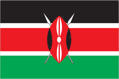
| Flag description: three equal horizontal bands of black (top), red, and green; the red band is edged in white; a large Maasai warrior’s shield covering crossed spears is superimposed at the center; black symbolizes the majority population, red the bloodshed in the struggle for freedom, green stands for natural wealth, and white for peace; the shield and crossed spears symbolize the defense of freedom. | Border length: total: 3,457 km. Border countries (total: 5): Ethiopia 867 km, Somalia 684 km, South Sudan 317 km, Tanzania 775 km, Uganda 814 km. |
Did you know about Kenya?
- Kenyabe came a colony in 1920 having previously been known as British East Africa. It became independent in 1963 and a republic in 1964.
- Kenya has more than 50 game reserves, national parks, and marine reservations.
- Thousands of tourists visit Kenya each year to view the spectacular array of wild animals in their natural habitats.
Facts of Kenya (KE)
Name conventional long form: Republic of Kenya, conventional short form: Kenya, local long form: Republic of Kenya/Jamhuri ya Kenya, local short form: Kenya, former: British East Africaetymolgy: named for Mount Kenya; the meaning of the name is unclear but may derive from the Kikuyu, Embu, and Kamba words “kirinyaga,” “kirenyaa,” and “kiinyaa” – all of which mean “God’s resting place”
Codes: ISO; KE, Internet; .ke
Capital city: Nairobi
Language(s): English (official language), Kiswahili (official language), numerous indigenous languages
National holiday(s): Independence Day, 12 December (1963); Madaraka Day, 1 June (1963); Mashujaa Day (or Heroes’ Day), 20 October (2010)
Motto: Harambee (Let us all pull together)
Currency: Kenyan shilling (KES), since 1966
GPS: 1 00 N, 38 00 E, Nairobi; 1 17 S 36 49 E
Location: Eastern Africa, bordering the Indian Ocean, between Somalia and Tanzania
Geography note: the Kenyan Highlands comprise one of the most successful agricultural production regions in Africa; glaciers are found on Mount Kenya, Africa’s second highest peak; unique physiography supports abundant and varied wildlife of scientific and economic value
Land boundaries: Ethiopia 867 km, Somalia 684 km, South Sudan 317 km, Tanzania 775 km, Uganda 814 km, total: 3,457 km
Maritime boundaries: N/A
Coastline: 536 km
Area: total: 580,367 sq km; land: 569,140 sq km, water: 11,227 sq km (total 224 080,86 mi2), five times the size of Ohio; slightly more than twice the size of Nevada.
Roadways: total: 160,878 km, paved: 11,189 km, unpaved: 149,689 km, note: includes 99 km of urban and other roads (2013)
Waterways: none specifically; the only significant inland waterway is the part of Lake Victoria within the boundaries of Kenya; Kisumu is the main port and has ferry connections to Uganda and Tanzania (2011)
Local time (capital): UTC+3, 8 hours ahead of Washington DC during Standard Time
Note to the local time: N/A
Population in Kenya: 50 950 879
Population in Nairobi: 3 064 800 (including the metropolitan areas)
Urbanization: urban population: 25.6% of total population (2015)
Major urban areas population: NAIROBI (capital) 3.915 million; Mombassa 1.104 million (2015)
Population growth rate: 1.81% (2016 estimate)
Birth rate: 25.1 births / 1,000 population (2016 estimate)
Death rate: 6.8 deaths / 1,000 population (2016 estimate)
Age structure: 0-14 years: 40.87% (male 9,592,017 / female 9,532,032) 15-24 years: 18.83% (male 4,398,554 / female 4,411,586) 25-54 years: 33.54% (male 7,938,111 / female 7,755,128) 55-64 years: 3.84% (male 819,665 / female 976,862) 65 years and over: 2.92% (male 590,961 / female 775,842) (2016 estimate)
Median age: total: 19.5 years; male: 19.4 years, female: 19.6 years (2016 estimate)
Ethnic groups: Kikuyu 22%, Luhya 14%, Luo 13%, Kalenjin 12%, Kamba 11%, Kisii 6%, Meru 6%, other African 15%, non-African (Asian, European, and Arab) 1%
Religions: Christian 83% (Protestant 47.7%, Catholic 23.4%, other Christian 11.9%), Muslim 11.2%, Traditionalists 1.7%, other 1.6%, none 2.4%, unspecified 0.2% (2009 estimate)
Government type: Unitary presidential constitutional republic
Legal system: mixed legal system of English common law, Islamic law, and customary law; judicial review in a new Supreme Court established pursuant to the new constitution
National anthem: Ee Mungu Nguvu Yetu (O God of all creation)
Known national hazards: recurring drought; flooding during rainy seasons, volcanism: limited volcanic activity; the Barrier (elev. 1,032 m) last erupted in 1921; South Island is the only other historically active volcano
Major infectious diseases: The degree of risk(s): very high food or waterborne diseases: bacterial and protozoal diarrhea, hepatitis A, and typhoid fever vectorborne disease: malaria, dengue fever, and Rift Valley feverwater contact disease: schistosomiasis animal contact disease: rabies (2016)
Land use: agricultural land: 48.1%; arable land 9.8%; permanent crops 0.9%; permanent pasture 37.4%; forest: 6.1%; other: 45.8% (2011 estimate)
Agricultural products: tea, coffee, corn, wheat, sugarcane, fruit, vegetables; dairy products, beef, fish, pork, poultry, eggs
Industries: small-scale consumer goods (plastic, furniture, batteries, textiles, clothing, soap, cigarettes, flour), agricultural products, horticulture, oil refining; aluminum, steel, lead; cement, commercial ship repair, tourism
Export commodities: tea, horticultural products, coffee, petroleum products, fish, cement
Main export partners: Uganda 11.2%, US 8.3%, Tanzania 8.1%, Netherlands 7.4%, UK 6%, Pakistan 4.2% (2015)
Import commodities: machinery and transportation equipment, petroleum products, motor vehicles, iron and steel, resins and plastics
Main import partners: China 30%, India 15.5%, UAE 5.7%, US 4.8%, Japan 4.7% (2015)
Navigate the countries in Africa faster and easier while driving, use the interactive Google maps for your driving directions. The continuously updated database contains over 220 countries and territories digitally mapped, hundreds of millions of businesses and places around the world positioned on the map.
Get fresh GPS navigation, traffic, and transit information – no matter what part of Kenya, Nairobi, any other city and country in Africa, or the world you’re in.
Do you like this Kenya information page? Please don’t forget to share it with others! Thank you.