Malawi Google maps and Driving Directions
Get free driving directions, Google maps, traffic information for Malawi, and Lilongwe (GPS: 13 58 S 33 47 E), the capital city of the country located in (the) Southern Africa, east of Zambia, west and north of Mozambique.
Find any address in Lilongwe on the Google map of Malawi (MW) with ease or calculate your up to date itinerary to and from Malawi or its neighboring counties like Mozambique, Tanzania, Zambia.
Sightseeing and exploring in Africa starts here, thanks to Google because its Earth Engine combines a multi-petabyte catalog of updated satellite imagery and geospatial datasets with planetary-scale analysis capabilities. Wonder the world, use the satellite map function of the Google maps to explore or see differences on the Earth’s surface, inland, or the surrounding areas of Malawi.
Google Maps Malawi
A former colony of the UK, Malawi lies landlocked in southeast Africa, following the Great Rift Valley. Its name means “the land where the sun is reflected in the water like fire.
Malawi is narrow elongated plateau with rolling plains, rounded hills, some mountains.
The map above fully covers Malawi with its road routes from cities to towns, road intersections in any region, provinces, prefectures, also with free driving directions in Lilongwe or to the neighboring towns and countries. To look at the detailed map about a particular quarter in Lilongwe, please click on the area and zoom to the place you are interested in the Google maps of Malawi (MW).
Be creative, use the extras of this Google map; This is a detailed, clear, zoomable, large road map of Malawi with its administrative divisions; 28 districts; Balaka, Blantyre, Chikwawa, Chiradzulu, Chitipa, Dedza, Dowa, Karonga, Kasungu, Likoma, Lilongwe, Machinga, Mangochi, Mchinji, Mulanje, Mwanza, Mzimba, Neno, Ntcheu, Nkhata Bay, Nkhotakota, Nsanje, Ntchisi, Phalombe, Rumphi, Salima, Thyolo, Zomba.
The interactive map above is also may be used as the satellite map of Malawi, or as a reverse search map for finding an address from its GPS coordinates.
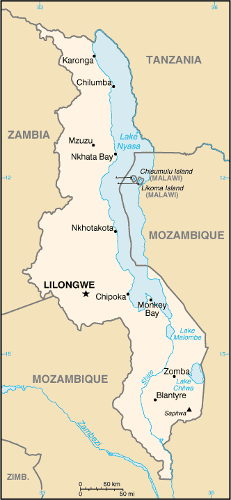
Malawi is a landlocked country about the size of Pennsylvania. Located in southeast Africa, it is surrounded by Mozambique, Zambia, and Tanzania. Lake Malawi, formerly Lake Nyasa, occupies most of the country’s eastern border. The north-south Rift Valley is flanked by mountain ranges and high plateau areas.
Malawi (area: 118 484 sq km / 45 746,91 sq mi), where the official language is Chichewa, English, lying in Africa and using the currency; Malawian kwacha (MWK), since 1971, set their clock to UTC+2. That means they are 7 hours ahead of Washington DC during Standard Time in Lilongwe, the capital. Note to the time difference: N/A.
The climate in Malawi; Mainly subtropical. The south is hot and humid. Highlands are cooler.
Geography in a nutshell; Lake Nyasa takes up one-fifth of the landscape. Highlands lie west of the lake. Much of the land is covered by forests and savanna.
Click here for more detailed information about Malawi.
Driving directions Malawi
The Google maps and Google Satellite maps of Malawi above showing the country, located next to Mozambique, Tanzania, Zambia. For your further reference, the latitude and longitude coordinates of Malawi are 13 30 S, 34 00 E , while the capital, Lilongwe found at 13 58 S 33 47 E.
When you are traveling around Malawi, Lilongwe, or its other cities, use this routing tool, providing up to date route planning service free of charge.
Look no further; get accurate driving directions in Malawi, Africa, by filling the route planner form below.
Since Google acquired and introduced its digitalized maps in 2004, you’re probably familiar with its base functions, like finding an address or driving directions to locations. Still, Google maps also accommodate bicyclists, pedestrians, and also public transportation with special directions and customizable routes.
About Malawi and the capital, Lilongwe
 |
 |
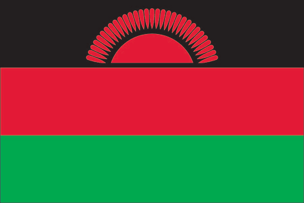
| The national flag of Malawi | Borderline map of Malawi |
| Flag description: three equal horizontal bands of black (top), red, and green with a radiant, rising, red sun centered on the black band; black represents the native peoples, red the bloodshed in their struggle for freedom, and green the color of nature; the rising sun represents the hope of freedom for the continent of Africa. | Border length: total: 2,857 km. Border countries (total: 3): Mozambique 1,498 km, Tanzania 512 km, Zambia 847 km. |
Did you know about Malawi?
- As Nyasaland, Malawi formed part of British Rhodesia and Nyasaland from 1953-1963. It became fully independent in 1964.
- Lake Nyasa is 353 miles(568 km) in length and contains at least 500 species of fish.
- Lake Nyasa accounts for one-fifth of the area of Malawi, and is home to many brightly colored fish that are exported to aquariums around the world.
Facts of Malawi (MW)
Name conventional long form: Republic of Malawi, conventional short form: Malawi, local long form: Dziko la Malawi, local short form: Malawi, former: British Central African Protectorate, Nyasaland Protectorate, Nyasaland, etymology: named for the East African Maravi kingdom of the 16th century; the word “maravi” means “fire flames”
Codes: ISO; MW, Internet; .mw
Capital city: Lilongwe
Language(s): English (official language), Chichewa (common), Chinyanja, Chiyao, Chitumbuka, Chilomwe, Chinkhonde, Chingoni, Chisena, Chitonga, Chinyakyusa, Chilambya
National holiday(s): Independence Day (Republic Day), 6 July (1964)
Motto: Unity and Freedom
Currency: Malawian kwacha (MWK), since 1971
GPS: 13 30 S, 34 00 E, Lilongwe; 13 58 S 33 47 E
Location: Southern Africa, east of Zambia, west and north of Mozambique
Geography note: landlocked country; Lake Nyasa, some 580 km long, is the country’s most prominent physical feature; it contains more fish species than any other lake on earth
Land boundaries: Mozambique 1,498 km, Tanzania 512 km, Zambia 847 km, total: 2,857 km
Maritime boundaries: N/A
Coastline: 0 km (landlocked country)
Area: total: 118,484 sq km; land: 94,080 sq km, water: 24,404 sq km (total 45 746,91 mi2), slightly smaller than Pennsylvania.
Roadways: total: 15,450 km, paved: 6,951 km, unpaved: 8,499 km (2011)
Waterways: 700 km (on Lake Nyasa [Lake Malawi] and Shire River) (2010)
Local time (capital): UTC+2, 7 hours ahead of Washington DC during Standard Time
Note to the local time: N/A
Population in Malawi: 19 164 728
Population in Lilongwe: 499 200 (including the metropolitan areas)
Urbanization: urban population: 16.3% of total population (2015)
Major urban areas population: LILONGWE (capital) 905,000; Blantyre-Limbe 808,000 (2015)
Population growth rate: 3.32% (2016 estimate)
Birth rate: 41.3 births / 1,000 population (2016 estimate)
Death rate: 8.1 deaths / 1,000 population (2016 estimate)
Age structure: 0-14 years: 46.53% (male 4,299,076 / female 4,341,129) 15-24 years: 20.49% (male 1,889,240 / female 1,915,843) 25-54 years: 27.26% (male 2,512,247 / female 2,549,766) 55-64 years: 3.03% (male 268,691 / female 294,713) 65 years and over: 2.69% (male 220,608 / female 279,008) (2016 estimate)
Median age: total: 16.5 years; male: 16.3 years, female: 16.6 years (2016 estimate)
Ethnic groups: Chewa 32.6%, Lomwe 17.6%, Yao 13.5%, Ngoni 11.5%, Tumbuka 8.8%, Nyanja 5.8%, Sena 3.6%, Tonga 2.1%, Ngonde 1%, other 3.5%
Religions: Christian 82.6%, Muslim 13%, other 1.9%, none 2.5% (2008 estimate)
Government type: Unitary presidential republic
Legal system: mixed legal system of English common law and customary law; judicial review of legislative acts in the Supreme Court of Appeal
National anthem: Mulungu dalitsa Malawi (O God Bless Our Land of Malawi)
Known national hazards: N/A
Major infectious diseases: The degree of risk(s): very high food or waterborne diseases: bacterial and protozoal diarrhea, hepatitis A, and typhoid fever vectorborne diseases: malaria and dengue feverwater contact disease: schistosomiasis animal contact disease: rabies (2016)
Land use: agricultural land: 59.2%; arable land 38.2%; permanent crops 1.4%; permanent pasture 19.6%; forest: 34%; other: 6.8% (2011 estimate)
Agricultural products: tobacco, sugarcane, cotton, tea, corn, potatoes, cassava (manioc, tapioca), sorghum, pulses, groundnuts, Macadamia nuts; cattle, goats
Industries: tobacco, tea, sugar, sawmill products, cement, consumer goods
Export commodities: tobacco 53%, tea, sugar, cotton, coffee, peanuts, wood products, apparel (2010 estimate)
Main export partners: Belgium 15.8%, Zimbabwe 12%, India 6.9%, South Africa 6.2%, US 6%, Russia 5.6%, Germany 4.6% (2015)
Import commodities: food, petroleum products, semi-manufactures, consumer goods, transportation equipment
Main import partners: South Africa 26.4%, China 16.7%, India 12%, Zambia 10.3%, Tanzania 6% (2015)
Navigate the countries in Africa faster and easier while driving, use the interactive Google maps for your driving directions. The continuously updated database contains over 220 countries and territories digitally mapped, hundreds of millions of businesses and places around the world positioned on the map.
Get fresh GPS navigation, traffic, and transit information – no matter what part of Malawi, Lilongwe, any other city and country in Africa, or the world you’re in.
Do you like this Malawi information page? Please don’t forget to share it with others! Thank you.