Libya Google maps and Driving Directions
Get free driving directions, Google maps, traffic information for Libya, and Tripoli (GPS: 32 53 N 13 10 E), the capital city of the country located in (the) Northern Africa, bordering the Mediterranean Sea, between Egypt, Tunisia, and Algeria.
Find any address in Tripoli on the Google map of Libya (LY) with ease or calculate your up to date itinerary to and from Libya or its neighboring counties like Algeria, Chad, Egypt, Niger, Sudan, Tunisia.
Sightseeing and exploring in Africa starts here, thanks to Google because its Earth Engine combines a multi-petabyte catalog of updated satellite imagery and geospatial datasets with planetary-scale analysis capabilities. Wonder the world, use the satellite map function of the Google maps to explore or see differences on the Earth’s surface, inland, or the surrounding areas of Libya.
Google Maps Libya
Situated on north Africas Mediterranean coast, Libya was declared a revolutionary state in 1969 by Colonel Gaddafi, who promotes Islam, African unity, and a communal lifestyle.
Libya is mostly barren, flat to undulating plains, plateaus, depressions.
The map above fully covers Libya with its road routes from cities to towns, road intersections in any region, provinces, prefectures, also with free driving directions in Tripoli or to the neighboring towns and countries. To look at the detailed map about a particular quarter in Tripoli, please click on the area and zoom to the place you are interested in the Google maps of Libya (LY).
Be creative, use the extras of this Google map; This is a detailed, clear, zoomable, large road map of Libya with its administrative divisions; 22 districts (shabiyat, singular – shabiyat); Al Butnan, Al Jabal al Akhdar, Al Jabal al Gharbi, Al Jafarah, Al Jufrah, Al Kufrah, Al Marj, Al Marqab, Al Wahat, An Nuqat al Khams, Az Zawiyah, Banghazi, Darnah, Ghat, Misratah, Murzuq, Nalut, Sabha, Surt, Tarabulus, Wadi al Hayat, Wadi ash Shati.
The interactive map above is also may be used as the satellite map of Libya, or as a reverse search map for finding an address from its GPS coordinates.
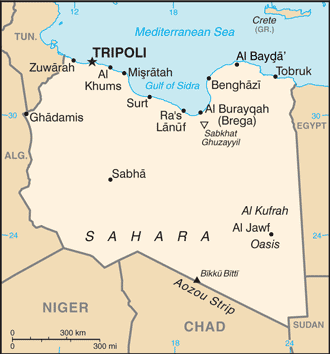
Libya stretches along the northeast coast of Africa between Tunisia and Algeria on the west and Egypt on the east to the south are the Sudan, Chad, and Niger. It is one-sixth larger than Alaska. Much of the country lies within the Sahara. Along the Mediterranean coast and farther inland is arable plateau land.
Libya (area: 1 759 540 sq km / 679 361,91 sq mi), where the official language is Arabic, lying in Africa and using the currency; Libyan dinar (LYD), since 1971, set their clock to UTC+2. That means they are 7 hours ahead of Washington DC during Standard Time in Tripoli, the capital. Note to the time difference: N/A.
The climate in Libya; Hot and arid. The coastal area has a temperate climate, with mild, wet winters and hot, dry summers.
Geography in a nutshell; Apart from the coastal strip and a mountain range in the south, Libya is desert or semidesert. Natural oases provide the agricultural land.
Click here for more detailed information about Libya.
Driving directions Libya
The Google maps and Google Satellite maps of Libya above showing the country, located next to Algeria, Chad, Egypt, Niger, Sudan, Tunisia. For your further reference, the latitude and longitude coordinates of Libya are 25 00 N, 17 00 E , while the capital, Tripoli found at 32 53 N 13 10 E.
When you are traveling around Libya, Tripoli, or its other cities, use this routing tool, providing up to date route planning service free of charge.
Look no further; get accurate driving directions in Libya, Africa, by filling the route planner form below.
Since Google acquired and introduced its digitalized maps in 2004, you’re probably familiar with its base functions, like finding an address or driving directions to locations. Still, Google maps also accommodate bicyclists, pedestrians, and also public transportation with special directions and customizable routes.
About Libya and the capital, Tripoli
 |
 |
| The national flag of Libya | Borderline map of Libya |
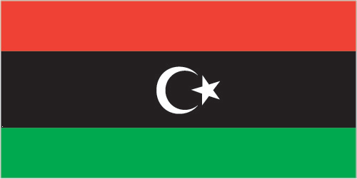
| Flag description: three horizontal bands of red (top), black (double width), and green with a white crescent and star centered on the black stripe; the National Transitional Council reintroduced this flag design of the former Kingdom of Libya (1951-1969) on 27 February 2011; it replaced the former all-green banner promulgated by the QADHAFI regime in 1977; the colors represent the three major regions of the country: red stands for Fezzan, black symbolizes Cyrenaica, and green denotes Tripolitania; the crescent and star represent Islam, the main religion of the country. | Border length: total: 4,339 km. Border countries (total: 6): Algeria 989 km, Chad 1,050 km, Egypt 1,115 km, Niger 342 km, Sudan 382 km, Tunisia 461 km. |
Did you know about Libya?
- Libya achieved independence in 1951, but in1969 the King deposed and Libya formed a republic led by Colonel Gadaffi.
- 90% of Libya is still desert, despite grand irrigation projects.
- Located between the Maghreb and Egypt, Libya was once a colony of the Roman Empire.
Facts of Libya (LY)
Name conventional long form: none, conventional short form: Libya, local long form: none, local short form: Libiya. Note: name derives from the Libu, an ancient Libyan tribe first mentioned in texts from the 13th century B.C.
Codes: ISO; LY, Internet; .ly
Capital city: Tripoli
Language(s): Arabic (official language), Italian, English (all widely understood in the major cities); Berber (Nafusi, Ghadamis, Suknah, Awjilah, Tamasheq)
National holiday(s): Liberation Day, 23 October (2011)
Motto: N/A
Currency: Libyan dinar (LYD), since 1971
GPS: 25 00 N, 17 00 E, Tripoli; 32 53 N 13 10 E
Location: Northern Africa, bordering the Mediterranean Sea, between Egypt, Tunisia, and Algeria
Geography note: more than 90% of the country is desert or semidesert
Land boundaries: Algeria 989 km, Chad 1,050 km, Egypt 1,115 km, Niger 342 km, Sudan 382 km, Tunisia 461 km, total: 4,339 km
Maritime boundaries: Mediterranean Sea
Coastline: 1,770 km
Area: total: 1,759,540 sq km; land: 1,759,540 sq km, water: 0 sq km (total 679 361,91 mi2), about 2.5 times the size of Texas; slightly larger than Alaska.
Roadways: total: 100,024 km, paved: 57,214 km, unpaved: 42,810 km (2003)
Waterways: N/A
Local time (capital): UTC+2, 7 hours ahead of Washington DC during Standard Time
Note to the local time: N/A
Population in Libya: 6 470 956
Population in Tripoli: 2 357 800 (including the metropolitan areas)
Urbanization: urban population: 78.6% of total population (2015)
Major urban areas population: TRIPOLI (capital) 1.126 million (2015)
Population growth rate: 1.8% (2016 estimate)
Birth rate: 17.8 births / 1,000 population (2016 estimate)
Death rate: 3.6 deaths / 1,000 population (2016 estimate)
Age structure: 0-14 years: 26.17% (male 875,430 / female 836,272) 15-24 years: 17.41% (male 586,713 / female 552,531) 25-54 years: 46.99% (male 1,613,168 / female 1,460,987) 55-64 years: 5.21% (male 174,023 / female 167,072) 65 years and over: 4.22% (male 137,409 / female 138,343) (2016 estimate)
Median age: total: 28.5 years; male: 28.6 years, female: 28.3 years (2016 estimate)
Ethnic groups: Berber and Arab 97%, other 3% (includes Greeks, Maltese, Italians, Egyptians, Pakistanis, Turks, Indians, and Tunisians)
Religions: Muslim (official; virtually all Sunni) 96.6%, Christian 2.7%, Buddhist 0.3%, Hindu
Government type: Republic
Legal system: Libya’s post-revolution legal system is in flux and driven by state and non-state entities
National anthem: Libya, Libya, Libya
Known national hazards: hot, dry, dust-laden ghibli is a southern wind lasting one to four days in spring and fall; dust storms, sandstorms
Major infectious diseases: N/A
Land use: agricultural land: 8.8%; arable land 1%; permanent crops 0.2%; permanent pasture 7.6%; forest: 0.1%; other: 91.1% (2011 estimate)
Agricultural products: wheat, barley, olives, dates, citrus, vegetables, peanuts, soybeans; cattle
Industries: petroleum, petrochemicals, aluminum, iron and steel, food processing, textiles, handicrafts, cement
Export commodities: crude oil, refined petroleum products, natural gas, chemicals
Main export partners: Italy 32.1%, Germany 11.3%, China 8%, France 8%, Spain 5.6%, Netherlands 5.4%, Syria 5.3% (2015)
Import commodities: machinery, semi-finished goods, food, transport equipment, consumer products
Main import partners: China 14.8%, Italy 12.9%, Turkey 11.1%, Tunisia 6.5%, France 6.1%, Spain 4.6%, Syria 4.5%, Egypt 4.4%, South Korea 4.3% (2015)
Navigate the countries in Africa faster and easier while driving, use the interactive Google maps for your driving directions. The continuously updated database contains over 220 countries and territories digitally mapped, hundreds of millions of businesses and places around the world positioned on the map.
Get fresh GPS navigation, traffic, and transit information – no matter what part of Libya, Tripoli, any other city and country in Africa, or the world you’re in.
Do you like this Libya information page? Please don’t forget to share it with others! Thank you.