Uganda Google maps and Driving Directions
Get free driving directions, Google maps, traffic information for Uganda, and Kampala (GPS: 0 19 N 32 33 E), the capital city of the country located in (the) East-Central Africa, west of Kenya, east of the Democratic Republic of the Congo.
Find any address in Kampala on the Google map of Uganda (UG) with ease or calculate your up to date itinerary to and from Uganda or its neighboring counties like Democratic Republic of Congo, Kenya, Rwanda, South Sudan, Tanzania.
Sightseeing and exploring in Africa starts here, thanks to Google because its Earth Engine combines a multi-petabyte catalog of updated satellite imagery and geospatial datasets with planetary-scale analysis capabilities. Wonder the world, use the satellite map function of the Google maps to explore or see differences on the Earth’s surface, inland, or the surrounding areas of Uganda.
Google Maps Uganda
Landlocked in east Africa, Uganda has a history of ethnic strife. Under President Museveni, steps have been taken to restore peace and to rebuild the economy and democracy.
Uganda is mostly plateau with rim of mountains.
The map above fully covers Uganda with its road routes from cities to towns, road intersections in any region, provinces, prefectures, also with free driving directions in Kampala or to the neighboring towns and countries. To look at the detailed map about a particular quarter in Kampala, please click on the area and zoom to the place you are interested in the Google maps of Uganda (UG).
Be creative, use the extras of this Google map; This is a detailed, clear, zoomable, large road map of Uganda with its administrative divisions; 111 districts and 1 capital city*; Abim, Adjumani, Agago, Alebtong, Amolatar, Amudat, Amuria, Amuru, Apac, Arua, Budaka, Bududa, Bugiri, Buhweju, Buikwe, Bukedea, Bukomansimbi, Bukwa, Bulambuli, Buliisa, Bundibugyo, Bushenyi, Busia, Butaleja, Butambala, Buvuma, Buyende, Dokolo, Gomba, Gulu, Hoima, Ibanda, Iganga, Isingiro, Jinja, Kaabong, Kabale, Kabarole, Kaberamaido, Kalangala, Kaliro, Kalungu, Kampala*, Kamuli, Kamwenge, Kanungu, Kapchorwa, Kasese, Katakwi, Kayunga, Kibaale, Kiboga, Kibuku, Kiruhura, Kiryandongo, Kisoro, Kitgum, Koboko, Kole, Kotido, Kumi, Kween, Kyankwanzi, Kyegegwa, Kyenjojo, Lamwo, Lira, Luuka, Luwero, Lwengo, Lyantonde, Manafwa, Maracha, Masaka, Masindi, Mayuge, Mbale, Mbarara, Mitooma, Mityana, Moroto, Moyo, Mpigi, Mubende, Mukono, Nakapiripirit, Nakaseke, Nakasongola, Namayingo, Namutumba, Napak, Nebbi, Ngora, Ntoroko, Ntungamo, Nwoya, Otuke, Oyam, Pader, Pallisa, Rakai, Rubirizi, Rukungiri, Sembabule, Serere, Sheema, Sironko, Soroti, Tororo, Wakiso, Yumbe, Zombo; note – four new districts, Kagadi, Kakumiro, Omoro, and Rubanda, have been reported, but not yet vetted by the US Board on Geographic Names.
The interactive map above is also may be used as the satellite map of Uganda, or as a reverse search map for finding an address from its GPS coordinates.
Uganda, twice the size of Pennsylvania, is in East Africa. It is bordered on the west by Congo, on the north by the Sudan, on the east by Kenya, and on the south by Tanzania and Rwanda. The country, which lies across the equator, is divided into three main areas – swampy lowlands, a fertile plateau with wooded hills, and a desert region. Lake Victoria forms part of the southern border.
Uganda (area: 241 550 sq km / 93 262,94 sq mi), where the official language is English, Kiswahili, Swahili, lying in Africa and using the currency; Ugandan shilling (UGX), since 1987, set their clock to UTC+3. That means they are 8 hours ahead of Washington DC during Standard Time in Kampala, the capital. Note to the time difference: N/A.
The climate in Uganda; Altitude and the influence of the lakes modify the equatorial climate. Rain falls throughout the year; spring is the wettest period.
Geography in a nutshell; Predominantly a large plateau with the Ruwenzori mountain range and the Great Rift Valley in the west. Lake Victoria lies to the southeast. Vegetation is of savanna type.
Click here for more detailed information about Uganda.
Driving directions Uganda
The Google maps and Google Satellite maps of Uganda above showing the country, located next to Democratic Republic of Congo, Kenya, Rwanda, South Sudan, Tanzania. For your further reference, the latitude and longitude coordinates of Uganda are 1 00 N, 32 00 E , while the capital, Kampala found at 0 19 N 32 33 E.
When you are traveling around Uganda, Kampala, or its other cities, use this routing tool, providing up to date route planning service free of charge.
Look no further; get accurate driving directions in Uganda, Africa, by filling the route planner form below.
[xyz-ihs snippet=”routing”]
Since Google acquired and introduced its digitalized maps in 2004, you’re probably familiar with its base functions, like finding an address or driving directions to locations. Still, Google maps also accommodate bicyclists, pedestrians, and also public transportation with special directions and customizable routes.
About Uganda and the capital, Kampala
 |
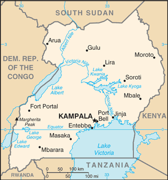 |
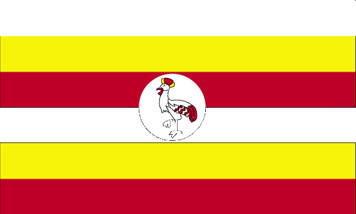
| The national flag of Uganda | Borderline map of Uganda |
| Flag description: six equal horizontal bands of black (top), yellow, red, black, yellow, and red; a white disk is superimposed at the center and depicts a grey crowned crane (the national symbol) facing the hoist side; black symbolizes the African people, yellow sunshine and vitality, red African brotherhood; the crane was the military badge of Ugandan soldiers under the UK. | Border length: total: 2,729 km. Border countries (total: 5): Democratic Republic of the Congo 877 km, Kenya 814 km, Rwanda 172 km, South Sudan 475 km, Tanzania 391 km. |
Did you know about Uganda?
- Since independence in 1962, Uganda has suffered years of upheaval. Under the current regime some stability has been restored.
- Lake Victoria is the worlds third-largest lake.
- To help boost fish stocks and provide sport for Ugandas tourists, Nile perch were introduced into Lake Victoria. Unfortunately, they ate all the other fish and are now simply a great menace!
Facts of Uganda (UG)
Name conventional long form: Republic of Uganda, conventional short form: Uganda, etymology: from the Swahili “Buganda,” adopted by the British as the name for their East African colony in 1894; Buganda had been a powerful East African state during the 18th and 19th centuries
Codes: ISO; UG, Internet; .ug
Capital city: Kampala
Language(s): English (official language national language, taught in grade schools, used in courts of law and by most newspapers and some radio broadcasts), Ganda or Luganda (most widely used of the Niger-Congo languages, preferred for native language publications in the capital and may be taught in school), other Niger-Congo languages, Nilo-Saharan languages, Swahili, Arabic
National holiday(s): Independence Day, 9 October (1962)
Motto: For God and My Country
Currency: Ugandan shilling (UGX), since 1987
GPS: 1 00 N, 32 00 E, Kampala; 0 19 N 32 33 E
Location: East-Central Africa, west of Kenya, east of the Democratic Republic of the Congo
Geography note: landlocked country; fertile, well-watered country with many lakes and rivers
Land boundaries: Democratic Republic of the Congo 877 km, Kenya 814 km, Rwanda 172 km, South Sudan 475 km, Tanzania 391 km, total: 2,729 km
Maritime boundaries: N/A
Coastline: 0 km (landlocked country)
Area: total: 241,038 sq km; land: 197,100 sq km, water: 43,938 sq km (total 93 262,94 mi2), slightly smaller than Oregon.
Roadways: total: 20,000 km (excludes local roads)paved: 3,264 km, unpaved: 16,736 km (2011)
Waterways: (there are no long navigable stretches of river in Uganda; parts of the Albert Nile that flow out of Lake Albert in the northwestern part of the country are navigable; several lakes including Lake Victoria and Lake Kyoga have substantial traffic; Lake Albert is navigable along a 200-km stretch from its northern tip to its southern shores) (2011)
Local time (capital): UTC+3, 8 hours ahead of Washington DC during Standard Time
Note to the local time: N/A
Population in Uganda: 44 270 563
Population in Kampala: 1 659 000 (including the metropolitan areas)
Urbanization: urban population: 16.1% of total population (2015)
Major urban areas population: KAMPALA (capital) 1.936 million (2015)
Population growth rate: 3.22% (2016 estimate)
Birth rate: 43.4 births / 1,000 population (2016 estimate)
Death rate: 10.4 deaths / 1,000 population (2016 estimate)
Age structure: 0-14 years: 48.26% (male 9,223,926 / female 9,268,714) 15-24 years: 21.13% (male 4,010,464 / female 4,087,350) 25-54 years: 26.1% (male 5,005,264 / female 4,997,907) 55-64 years: 2.5% (male 460,000 / female 496,399) 65 years and over: 2.01% (male 337,787 / female 431,430) (2016 estimate)
Median age: total: 15.7 years; male: 15.6 years, female: 15.8 years (2016 estimate)
Ethnic groups: Baganda 16.5%, Banyankole 9.6%, Basoga 8.8%, Bakiga 7.1%, Iteso 7%, Langi 6.3%, Bagisu 4.9%, Acholi 4.4%, Lugbara 3.3%, other 32.1% (2014 estimate)
Religions: Protestant 45.1% (Anglican 32.0%, Pentecostal/Born Again/Evangelical 11.1%, Seventh Day Adventist 1.7%, Baptist .3%), Roman Catholic 39.3%, Muslim 13.7%, other 1.6%, none 0.2% (2014 estimate)
Government type: Semi-presidential republic
Legal system: mixed legal system of English common law and customary law
National anthem: Oh Uganda, Land of Beauty
Known national hazards: N/A
Major infectious diseases: The degree of risk(s): very high food or waterborne diseases: bacterial diarrhea, hepatitis A and E, and typhoid fever vectorborne diseases: malaria, dengue fever, and trypanosomiasis-Gambiense (African sleeping sickness)water contact disease: schistosomiasis animal contact disease: rabies (2016)
Land use: agricultural land: 71.2%; arable land 34.3%; permanent crops 11.3%; permanent pasture 25.6%; forest: 14.5%; other: 14.3% (2011 estimate)
Agricultural products: coffee, tea, cotton, tobacco, cassava (manioc, tapioca), potatoes, corn, millet, pulses, cut flowers; beef, goat meat, milk, poultry, and fish
Industries: sugar, brewing, tobacco, cotton textiles; cement, steel production
Export commodities: coffee, fish and fish products, tea, cotton, flowers, horticultural products; gold
Main export partners: Rwanda 10.7%, UAE 9.9%, Democratic Republic of the Congo 9.8%, Kenya 9.7%, Italy 5.8%, Netherlands 4.8%, Germany 4.7%, China 4.1% (2015)
Import commodities: capital equipment, vehicles, petroleum, medical supplies; cereals
Main import partners: Kenya 16.4%, UAE 15.5%, India 13.4%, China 13.1% (2015)
Navigate the countries in Africa faster and easier while driving, use the interactive Google maps for your driving directions. The continuously updated database contains over 220 countries and territories digitally mapped, hundreds of millions of businesses and places around the world positioned on the map.
Get fresh GPS navigation, traffic, and transit information – no matter what part of Uganda, Kampala, any other city and country in Africa, or the world you’re in.
Do you like this Uganda information page? Please don’t forget to share it with others! Thank you.