Turkey Google maps and Driving Directions
Get free driving directions, Google maps, traffic information for Turkey, and Ankara (GPS: 39 56 N 32 52 E), the capital city of the country located in (the) Southeastern Europe and Southwestern Asia (that portion of Turkey west of the Bosporus is geographically part of Europe), bordering the Black Sea, between Bulgaria and Georgia, and bordering the Aegean Sea and the Mediterranean Sea, between Greece and Syria.
Find any address in Ankara on the Google map of Turkey (TR) with ease or calculate your up to date itinerary to and from Turkey or its neighboring counties like Armenia, Azerbaijan, Bulgaria, Georgia, Greece, Iran, Iraq, Syria.
Sightseeing and exploring in Asia starts here, thanks to Google because its Earth Engine combines a multi-petabyte catalog of updated satellite imagery and geospatial datasets with planetary-scale analysis capabilities. Wonder the world, use the satellite map function of the Google maps to explore or see differences on the Earth’s surface, inland, or the surrounding areas of Turkey.
Google Maps Turkey
Lying partly in the region of eastern Thrace in Europe, but mostly in Asia, Turkeys position gives it significant influence in the Mediterranean, the Black Sea, and the Middle East.
Turkey is high central plateau (Anatolia); narrow coastal plain; several mountain ranges.
The map above fully covers Turkey with its road routes from cities to towns, road intersections in any region, provinces, prefectures, also with free driving directions in Ankara or to the neighboring towns and countries. To look at the detailed map about a particular quarter in Ankara, please click on the area and zoom to the place you are interested in the Google maps of Turkey (TR).
Be creative, use the extras of this Google map; This is a detailed, clear, zoomable, large road map of Turkey with its administrative divisions; 81 provinces (iller, singular – ili); Adana, Adiyaman, Afyonkarahisar, Agri, Aksaray, Amasya, Ankara, Antalya, Ardahan, Artvin, Aydin, Balikesir, Bartin, Batman, Bayburt, Bilecik, Bingol, Bitlis, Bolu, Burdur, Bursa, Canakkale, Cankiri, Corum, Denizli, Diyarbakir, Duzce, Edirne, Elazig, Erzincan, Erzurum, Eskisehir, Gaziantep, Giresun, Gumushane, Hakkari, Hatay, Igdir, Isparta, Istanbul, Izmir (Smyrna), Kahramanmaras, Karabuk, Karaman, Kars, Kastamonu, Kayseri, Kilis, Kirikkale, Kirklareli, Kirsehir, Kocaeli, Konya, Kutahya, Malatya, Manisa, Mardin, Mersin, Mugla, Mus, Nevsehir, Nigde, Ordu, Osmaniye, Rize, Sakarya, Samsun, Sanliurfa, Siirt, Sinop, Sirnak, Sivas, Tekirdag, Tokat, Trabzon (Trebizond), Tunceli, Usak, Van, Yalova, Yozgat, Zonguldak.
The interactive map above is also may be used as the satellite map of Turkey, or as a reverse search map for finding an address from its GPS coordinates.
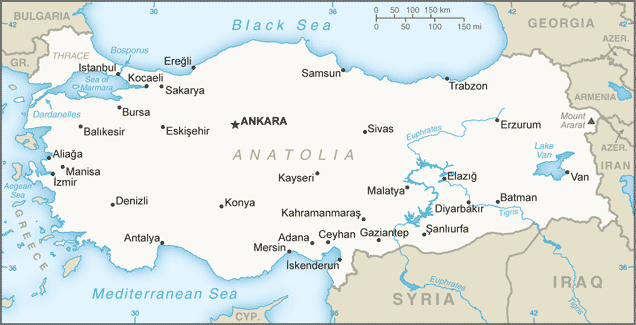
Turkey is at the northeast end of the Mediterranean Sea in southeast Europe and southwest Asia. To the north is the Black Sea and to the west is the Aegean Sea. Its neighbors are Greece and Bulgaria to the west, Russia, Ukraine, and Romania to the north and northwest (through the Black Sea), Georgia, Armenia, Azerbaijan, and Iran to the east, and Syria and Iraq to the south. The Dardanelles, the Sea of Marmara, and the Bosporus divide the country. Turkey in Europe comprises an area about equal to the state of Massachusetts. Turkey in Asia is about the size of Texas. Its center is a treeless plateau rimmed by mountains.
Turkey (area: 783 562 sq km / 302 534,86 sq mi), where the official language is Turkish, lying in Asia and using the currency; Turkish lira (TRY), since 2005, set their clock to UTC+2. That means they are 7 hours ahead of Washington DC during Standard Time in Ankara, the capital. Note to the time difference: Daylight saving time: +1hr begins last Sunday in March; ends last Sunday in October.
The climate in Turkey; Coast has a Mediterranean climate. Interior has cold, snowy winters and hot, dry summers.
Geography in a nutshell; Asian Turkey (Anatolia) is dominated by two mountain ranges, separated by a high, semidesert plateau. Coastal regions are fertile.
Click here for more detailed information about Turkey.
Driving directions Turkey
The Google maps and Google Satellite maps of Turkey above showing the country, located next to Armenia, Azerbaijan, Bulgaria, Georgia, Greece, Iran, Iraq, Syria. For your further reference, the latitude and longitude coordinates of Turkey are 39 00 N, 35 00 E , while the capital, Ankara found at 39 56 N 32 52 E.
When you are traveling around Turkey, Ankara, or its other cities, use this routing tool, providing up to date route planning service free of charge.
Look no further; get accurate driving directions in Turkey, Asia, by filling the route planner form below.
Since Google acquired and introduced its digitalized maps in 2004, you’re probably familiar with its base functions, like finding an address or driving directions to locations. Still, Google maps also accommodate bicyclists, pedestrians, and also public transportation with special directions and customizable routes.
About Turkey and the capital, Ankara
 |
 |
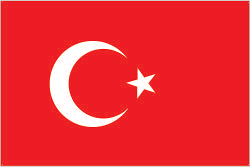
| The national flag of Turkey | Borderline map of Turkey |
| Flag description: red with a vertical white crescent moon (the closed portion is toward the hoist side) and white five-pointed star centered just outside the crescent opening; the flag colors and designs closely resemble those on the banner of the Ottoman Empire, which preceded modern-day Turkey; the crescent moon and star serve as insignia for Turkic peoples; according to one interpretation, the flag represents the reflection of the moon and a star in a pool of blood of Turkish warriors. | Border length: total: 2,816 km. Border countries (total: 8): Armenia 311 km, Azerbaijan 17 km, Bulgaria 223 km, Georgia 273 km, Greece 192 km, Iran 534 km, Iraq 367 km, Syria 899 km. |
About Ankara
Modern Ankara is two cities, a double identity that is due to the breakneck pace at which it has developed since being declared capital of the Turkish Republic in 1923. Until then, Ankara – known as Angora – had been a small provincial city, famous chiefly for the production of soft goat’s wool. This city still exists in and around the old citadel that was the site of the original settlement. The other Ankara is the modern metropolis that has grown up around a carefully planned attempt to create a seat of government worthy of a current, Western-looking state. Often overlooked, it merits a detour of a couple of days, especially if you’re traveling from Istanbul to Cappadocia.
Did you know about Turkey?
- Following Turkeys defeat in the World War I, Mustafa Kemal Atatürk deposed the Sultan in 1922, and declared the country a republic in 1923.
- Turkey had two of the seven wonders of the ancient world: the tomb of King Mausolus at Halicarnassus (now Bodrum), and the temple of Artemis at Ephesus.
- Turkey, like Russia, crosses the continents of Asia and Europe, although most of it is in Asia. Its Mediterranean coast attracts many tourists and is an important source of income.
Turkey has multiple identities. Poised between East and West, it’s a place where mosques coexist with churches, and Roman ruins crumble alongside ancient Hittite sites. The country is politically secular, though the majority of the population is Muslim, and it’s an immensely rewarding place to travel, not least because of the people, whose reputation for friendliness and hospitality richly deserved.
Much of the country’s delights are inexpensive pleasures. Whether it’s indulging in tasty gözleme (stuffed flatbreads) or dancing in backstreet bars, there are plenty of activities to consume your time but not your budget. Most visitors begin their trip in Istanbul, a heady mixture of European shopping districts, Byzantine and Ottoman architecture, and Anatolian cultural influences. South from here, small country towns interspersed by swathes of olive groves and several ancient sites, notably Ephesus.
Beyond the functional city of İzmir, the Aegean coast dotted with tourist resorts, including hedonistic party towns such as Bodrum and Marmaris. The aptly named Turquoise Coast is home to resorts such as Fethiye and Kaş, famous for their fabulous water- and adventure-sports facilities. Inland is spectacular Cappadocia, with its well-known rock churches, subterranean cities, and landscape studded with cave dwellings. Further north, Ankara, Turkey’s capital, is a planned city whose contrived Western feel gives some indication of the priorities of the modern Turkish Republic. Further south, Konya is the birthplace of the Mevlevi (whirling dervish) sufi sect.
Facts of Turkey (TR)
Name conventional long form: Republic of Turkey, conventional short form: Turkey, local long form: Turkiye Cumhuriyeti, local short form: Turkiye, etymology: the name means “Land of the Turks”
Codes: ISO; TR, Internet; .tr
Capital city: Ankara
Language(s): Turkish (official language), Kurdish, other minority languages
National holiday(s): Republic Day, 29 October (1923)
Motto: Yurtta Sulh, Cihanda Sulh
Currency: Turkish lira (TRY), since 2005
GPS: 39 00 N, 35 00 E, Ankara; 39 56 N 32 52 E
Location: Southeastern Europe and Southwestern Asia (that portion of Turkey west of the Bosporus is geographically part of Europe), bordering the Black Sea, between Bulgaria and Georgia, and bordering the Aegean Sea and the Mediterranean Sea, between Greece and Syria
Geography note: strategic location controlling the Turkish Straits (Bosporus, Sea of Marmara, Dardanelles) that link the Black and Aegean Seas; Mount Ararat, the legendary landing place of Noah’s ark, is in the far eastern portion of the country
Land boundaries: Armenia 311 km, Azerbaijan 17 km, Bulgaria 223 km, Georgia 273 km, Greece 192 km, Iran 534 km, Iraq 367 km, Syria 899 km, total: 2,816 km
Maritime boundaries: N/A
Coastline: 7,200 km
Area: total: 783,562 sq km; land: 769,632 sq km, water: 13,930 sq km (total 302 534,86 mi2), slightly larger than Texas.
Roadways: total: 385,754 km, paved: 352,268 km (includes 2,127 km of expressways), unpaved: 33,486 km (2012)
Waterways: 1,200 km (2010)
Local time (capital): UTC+2, 7 hours ahead of Washington DC during Standard Time
Note to the local time: Daylight saving time: +1hr begins last Sunday in March; ends last Sunday in October
Population in Turkey: 81 916 871
Population in Ankara: 4 194 000 (including the metropolitan areas)
Urbanization: urban population: 73.4% of total population (2015)
Major urban areas population: Istanbul 14.164 million; ANKARA (capital) 4.75 million; Izmir 3.04 million; Bursa 1.923 million; Adana 1.83 million; Gaziantep 1.528 million (2015)
Population growth rate: 0.9% (2016 estimate)
Birth rate: 16 births / 1,000 population (2016 estimate)
Death rate: 5.9 deaths / 1,000 population (2016 estimate)
Age structure: 0-14 years: 25.08% (male 10,303,153 / female 9,833,713) 15-24 years: 16.11% (male 6,605,634 / female 6,329,921) 25-54 years: 43.15% (male 17,541,137 / female 17,094,141) 55-64 years: 8.36% (male 3,335,021 / female 3,374,965) 65 years and over: 7.3% (male 2,603,655 / female 3,253,264) (2016 estimate)
Median age: total: 30.5 years; male: 30.1 years, female: 31 years (2016 estimate)
Ethnic groups: Turkish 70-75%, Kurdish 19%, other minorities 7-12% (2016 estimate)
Religions: Muslim 99.8% (mostly Sunni), other 0.2% (mostly Christians and Jews)
Government type: Unitary parliamentary constitutional republic
Legal system: civil law system based on various European legal systems notably the Swiss civil code
National anthem: Istiklâl Marsi (The Independence March)
Known national hazards: severe earthquakes, especially in northern Turkey, along an arc extending from the Sea of Marmara to Lake Vanvolcanism: limited volcanic activity; its three historically active volcanoes; Ararat, Nemrut Dagi, and Tendurek Dagi have not erupted since the 19th century or earlier
Major infectious diseases: N/A
Land use: agricultural land: 49.7%; arable land 26.7%; permanent crops 4%; permanent pasture 19%; forest: 14.9%; other: 35.4% (2011 estimate)
Agricultural products: tobacco, cotton, grain, olives, sugar beets, hazelnuts, pulses, citrus; livestock
Industries: textiles, food processing, automobiles, electronics, mining (coal, chromate, copper, boron), steel, petroleum, construction, lumber, paper
Export commodities: apparel, foodstuffs, textiles, metal manufactures, transport equipment
Main export partners: Germany 9.3%, UK 7.3%, Iraq 5.9%, Italy 4.8%, US 4.5%, France 4.1% (2015)
Import commodities: machinery, chemicals, semi-finished goods, fuels, transport equipment
Main import partners: China 12%, Germany 10.3%, Russia 9.9%, US 5.4%, Italy 5.1% (2015)
Navigate the countries in Asia faster and easier while driving, use the interactive Google maps for your driving directions. The continuously updated database contains over 220 countries and territories digitally mapped, hundreds of millions of businesses and places around the world positioned on the map.
Get fresh GPS navigation, traffic, and transit information – no matter what part of Turkey, Ankara, any other city and country in Asia, or the world you’re in.
Do you like this Turkey information page? Please don’t forget to share it with others! Thank you.