Egypt Google maps and Driving Directions
Get free driving directions, Google maps, traffic information for Egypt, and Cairo (GPS: 30 03 N 31 15 E), the capital city of the country located in (the) Northern Africa, bordering the Mediterranean Sea, between Libya and the Gaza Strip, and the Red Sea north of Sudan, and includes the Asian Sinai Peninsula.
Find any address in Cairo on the Google map of Egypt (EG) with ease or calculate your up to date itinerary to and from Egypt or its neighboring counties like Israel, Libya, Palestine, Sudan.
Sightseeing and exploring in Africa starts here, thanks to Google because its Earth Engine combines a multi-petabyte catalog of updated satellite imagery and geospatial datasets with planetary-scale analysis capabilities. Wonder the world, use the satellite map function of the Google maps to explore or see differences on the Earth’s surface, inland, or the surrounding areas of Egypt.
Google Maps Egypt
Occupying the northeast corner of Africa, Egypt is divided by the highly fertile Nile Valley. Its essentially pro-Western, military-backed regime is being challenged by Islamic fundamentalists.
Egypt is vast desert plateau interrupted by Nile valley and delta.
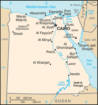
The map above fully covers Egypt with its road routes from cities to towns, road intersections in any region, provinces, prefectures, also with free driving directions in Cairo or to the neighboring towns and countries. To look at the detailed map about a particular quarter in Cairo, please click on the area and zoom to the place you are interested in the Google maps of Egypt (EG).
Be creative, use the extras of this Google map; This is a detailed, clear, zoomable, large road map of Egypt with its administrative divisions; 27 governorates (muhafazat, singular – muhafazat); Ad Daqahliyah, Al Bahr al Ahmar (Red Sea), Al Buhayrah, Al Fayyum, Al Gharbiyah, Al Iskandariyah (Alexandria), Al Isma’iliyah (Ismailia), Al Jizah (Giza), Al Minufiyah, Al Minya, Al Qahirah (Cairo), Al Qalyubiyah, Al Uqsur (Luxor), Al Wadi al Jadid (New Valley), As Suways (Suez), Ash Sharqiyah, Aswan, Asyut, Bani Suwayf, Bur Sa’id (Port Said), Dumyat (Damietta), Janub Sina’ (South Sinai), Kafr ash Shaykh, Matruh, Qina, Shamal Sina’ (North Sinai), Suhaj.
The interactive map above is also may be used as the satellite map of Egypt, or as a reverse search map for finding an address from its GPS coordinates.
Egypt, at the northeast corner of Africa on the Mediterranean Sea, is bordered on the west by Libya, on the south by the Sudan, and on the east by the Red Sea and Israel. It is nearly one and one-half times the size of Texas. Egypt is divided into two unequal, extremely arid regions by the landscape’s dominant feature, the northward-flowing Nile River. The Nile starts 100 mi (161 km) south of the Mediterranean and fans out to a sea front of 155 mi between the cities of Alexandria and Port Said.
Egypt (area: 1 002 450 sq km / 387 047,95 sq mi), where the official language is Arabic, lying in Africa and using the currency; Egyptian pound (EGP), set their clock to UTC+2. That means they are 7 hours ahead of Washington DC during Standard Time in Cairo, the capital. Note to the time difference: N/A.
The climate in Egypt; Summers are very hot, but winters are cooler. Rainfall is negligible, except on the coast.
Geography in a nutshell; Fertile Nile Valley separates arid Libyan Desert from smaller semiarid eastern desert. Sinai peninsula has mountains in south.
Click here for more detailed information about Egypt.
Driving directions Egypt
The Google maps and Google Satellite maps of Egypt above showing the country, located next to Israel, Libya, Palestine, Sudan. For your further reference, the latitude and longitude coordinates of Egypt are 27 00 N, 30 00 E , while the capital, Cairo found at 30 03 N 31 15 E.
When you are traveling around Egypt, Cairo, or its other cities, use this routing tool, providing up to date route planning service free of charge.
Look no further; get accurate driving directions in Egypt, Africa, by filling the route planner form below.
Since Google acquired and introduced its digitalized maps in 2004, you’re probably familiar with its base functions, like finding an address or driving directions to locations. Still, Google maps also accommodate bicyclists, pedestrians, and also public transportation with special directions and customizable routes.
About Egypt and the capital, Cairo
 |
 |
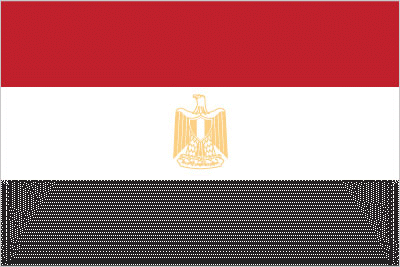
| The national flag of Egypt | Borderline map of Egypt |
| Flag description: three equal horizontal bands of red (top), white, and black; the national emblem (a gold Eagle of Saladin facing the hoist side with a shield superimposed on its chest above a scroll bearing the name of the country in Arabic) centered in the white band; the band colors derive from the Arab Liberation flag and represent oppression (black), overcome through bloody struggle (red), to be replaced by a bright future (white). Note: similar to the flag of Syria, which has two green stars in the white band, Iraq, which has an Arabic inscription centered in the white band, and Yemen, which has a plain white band. | Border length: total: 2,612 km. Border countries (total: 4): Gaza Strip 13 km, Israel 208 km, Libya 1,115 km, Sudan 1,276 km. |
Did you know about Egypt?
- Egypt was a kingdom until 1953. From 1958-1961 it joined the United Arab Republic and from 1972-1977 the Federation of Arab Republics.
- In 450 BCE Herodotus visited the already-ancient pyramids.
- The legendary Sphinx guards the pyramids of ancient Egypt at Giza.
Facts of Egypt (EG)
Name conventional long form: Arab Republic of Egypt, conventional short form: Egypt, local long form: Jumhuriyat Misr al-Arabiyah, local short form: Misr, former: United Arab Republic (with Syria), etymology: the English name “Egypt” derives from the ancient Greek name for the country “Aigyptos”; the Arabic name “Misr” can be traced to the ancient Akkadian “misru” meaning border or frontier
Codes: ISO; EG, Internet; .eg
Capital city: Cairo
Language(s): Arabic (official language), English and French widely understood by educated classes
National holiday(s): Revolution Day, 23 July (1952)
Motto: N/A
Currency: Egyptian pound (EGP)
GPS: 27 00 N, 30 00 E, Cairo; 30 03 N 31 15 E
Location: Northern Africa, bordering the Mediterranean Sea, between Libya and the Gaza Strip, and the Red Sea north of Sudan, and includes the Asian Sinai Peninsula
Geography note: controls Sinai Peninsula, only land bridge between Africa and remainder of Eastern Hemisphere; controls Suez Canal, a sea link between Indian Ocean and Mediterranean Sea; size, and juxtaposition to Israel, establish its major role in Middle Eastern geopolitics; dependence on upstream neighbors; dominance of Nile basin issues; prone to influxes of refugees from Sudan and the Palestinian territories
Land boundaries: Gaza Strip 13 km, Israel 208 km, Libya 1,115 km, Sudan 1,276 km, total: 2,612 km
Maritime boundaries: Mediterranean Sea, Red Sea
Coastline: 2,450 km
Area: total: 1,001,450 sq km; land: 995,450 sq km, water: 6,000 sq km (total 387 047,95 mi2), more than eight times the size of Ohio; slightly more than three times the size of New Mexico.
Roadways: total: 137,430 km, paved: 126,742 km (includes 838 km of expressways), unpaved: 10,688 km (2010)
Waterways: 3,500 km (includes the Nile River, Lake Nasser, Alexandria-Cairo Waterway, and numerous smaller canals in Nile Delta; the Suez Canal (193.5 km including approaches) is navigable by oceangoing vessels drawing up to 17.68 m) (2011)
Local time (capital): UTC+2, 7 hours ahead of Washington DC during Standard Time
Note to the local time: N/A
Population in Egypt: 99 375 741
Population in Cairo: 11 146 000 (including the metropolitan areas)
Urbanization: urban population: 43.1% of total population (2015)
Major urban areas population: CAIRO (capital) 18.772 million; Alexandria 4.778 million (2015)
Population growth rate: 2.51% (2016 estimate)
Birth rate: 30.3 births / 1,000 population (2016 estimate)
Death rate: 4.7 deaths / 1,000 population (2016 estimate)
Age structure: 0-14 years: 33.21% (male 16,268,862 / female 15,169,039) 15-24 years: 19.24% (male 9,371,819 / female 8,839,999) 25-54 years: 37.47% (male 18,020,332 / female 17,448,871) 55-64 years: 5.91% (male 2,771,399 / female 2,826,094) 65 years and over: 4.17% (male 1,937,119 / female 2,013,459) (2016 estimate)
Median age: total: 23.8 years; male: 23.5 years, female: 24.1 years (2016 estimate)
Ethnic groups: Egyptian 99.6%, other 0.4% (2006 census)
Religions: Muslim (predominantly Sunni) 90%, Christian (majority Coptic Orthodox, other Christians include Armenian Apostolic, Catholic, Maronite, Orthodox, and Anglican) 10% (2012 estimate)
Government type: Unitary semi-presidential republic
Legal system: mixed legal system based on Napoleonic civil and penal law, Islamic religious law, and vestiges of colonial-era laws; judicial review of the constitutionality of laws by the Supreme Constitutional Court
National anthem: Bilady, Bilady, Bilady (My country, my country, my country)
Known national hazards: periodic droughts; frequent earthquakes; flash floods; landslides; hot, driving windstorms called khamsin occur in spring; dust storms; sandstorms
Major infectious diseases: The degree of risk(s): intermediatefood or waterborne diseases: bacterial diarrhea, hepatitis A, and typhoid feverwater contact disease: schistosomiasis (2016)
Land use: agricultural land: 3.6%; arable land 2.8%; permanent crops 0.8%; permanent pasture 0%; forest: 0.1%; other: 96.3% (2011 estimate)
Agricultural products: cotton, rice, corn, wheat, beans, fruits, vegetables; cattle, water buffalo, sheep, goats
Industries: textiles, food processing, tourism, chemicals, pharmaceuticals, hydrocarbons, construction, cement, metals, light manufactures
Export commodities: crude oil and petroleum products, fruits and vegetables, cotton, textiles, metal products, chemicals, processed food
Main export partners: Saudi Arabia 9.1%, Italy 7.5%, Turkey 5.8%, UAE 5.1%, US 5.1%, UK 4.4%, India 4.1% (2015)
Import commodities: machinery and equipment, foodstuffs, chemicals, wood products, fuels
Main import partners: China 13%, Germany 7.7%, US 5.9%, Turkey 4.5%, Russia 4.4%, Italy 4.4%, Saudi Arabia 4.1% (2015)
Navigate the countries in Africa faster and easier while driving, use the interactive Google maps for your driving directions. The continuously updated database contains over 220 countries and territories digitally mapped, hundreds of millions of businesses and places around the world positioned on the map.
Get fresh GPS navigation, traffic, and transit information – no matter what part of Egypt, Cairo, any other city and country in Africa, or the world you’re in.
Do you like this Egypt information page? Please don’t forget to share it with others! Thank you.