Ethiopia Google maps and Driving Directions
Get free driving directions, Google maps, traffic information for Ethiopia, and Addis Ababa (GPS: 9 02 N 38 42 E), the capital city of the country located in (the) Eastern Africa, west of Somalia.
Find any address in Addis Ababa on the Google map of Ethiopia (ET) with ease or calculate your up to date itinerary to and from Ethiopia or its neighboring counties like Djibouti, Eritrea, Kenya, Somalia, South Sudan, Sudan.
Sightseeing and exploring in Africa starts here, thanks to Google because its Earth Engine combines a multi-petabyte catalog of updated satellite imagery and geospatial datasets with planetary-scale analysis capabilities. Wonder the world, use the satellite map function of the Google maps to explore or see differences on the Earth’s surface, inland, or the surrounding areas of Ethiopia.
Google Maps Ethiopia
The former empire of Ethiopia once dominated northeast Africa. A Marxist regime in 19741991, now a free-market democracy, it has suffered economic, civil, and natural crises.
Ethiopia is high plateau with central mountain range divided by Great Rift Valley.
The map above fully covers Ethiopia with its road routes from cities to towns, road intersections in any region, provinces, prefectures, also with free driving directions in Addis Ababa or to the neighboring towns and countries. To look at the detailed map about a particular quarter in Addis Ababa, please click on the area and zoom to the place you are interested in the Google maps of Ethiopia (ET).
Be creative, use the extras of this Google map; This is a detailed, clear, zoomable, large road map of Ethiopia with its administrative divisions; 9 ethnically based states (kililoch, singular – kilil) and 2 self-governing administrations* (astedaderoch, singular – astedader); Adis Abeba* (Addis Ababa), Afar, Amara (Amhara), Binshangul Gumuz, Dire Dawa*, Gambela Hizboch (Gambela Peoples), Hareri Hizb (Harari People), Oromiya (Oromia), Sumale (Somali), Tigray, Ye Debub Biheroch Bihereseboch na Hizboch (Southern Nations, Nationalities, and Peoples).
The interactive map above is also may be used as the satellite map of Ethiopia, or as a reverse search map for finding an address from its GPS coordinates.
Ethiopia is in east-central Africa, bordered on the west by the Sudan, the east by Somalia and Djibouti, the south by Kenya, and the northeast by Eritrea. It has several high mountains, the highest of which is Ras Dashan at 15,158 ft (4,620 m). The Blue Nile, or Abbai, rises in the northwest and flows in a great semicircle before entering the Sudan. Its chief reservoir, Lake Tana, lies in the northwest.
Ethiopia (area: 1 104 300 sq km / 426 372,44 sq mi), where the official language is None, lying in Africa and using the currency; Ethiopian birr (ETB), since 1945, set their clock to UTC+3. That means they are 8 hours ahead of Washington DC during Standard Time in Addis Ababa, the capital. Note to the time difference: N/A.
The climate in Ethiopia; Moderate, with summer rains. Highlands are warm, with night frost and snowfalls on the mountains.
Geography in a nutshell; Great Rift Valley divides mountainous northwest region from desert lowlands in northeast and southeast. Ethiopian Plateau is drained mainly by the Blue Nile.
Click here for more detailed information about Ethiopia.
Driving directions Ethiopia
The Google maps and Google Satellite maps of Ethiopia above showing the country, located next to Djibouti, Eritrea, Kenya, Somalia, South Sudan, Sudan. For your further reference, the latitude and longitude coordinates of Ethiopia are 8 00 N, 38 00 E , while the capital, Addis Ababa found at 9 02 N 38 42 E.
When you are traveling around Ethiopia, Addis Ababa, or its other cities, use this routing tool, providing up to date route planning service free of charge.
Look no further; get accurate driving directions in Ethiopia, Africa, by filling the route planner form below.
Since Google acquired and introduced its digitalized maps in 2004, you’re probably familiar with its base functions, like finding an address or driving directions to locations. Still, Google maps also accommodate bicyclists, pedestrians, and also public transportation with special directions and customizable routes.
About Ethiopia and the capital, Addis Ababa
 |
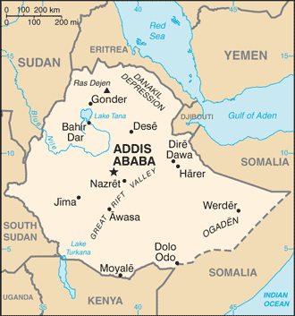 |
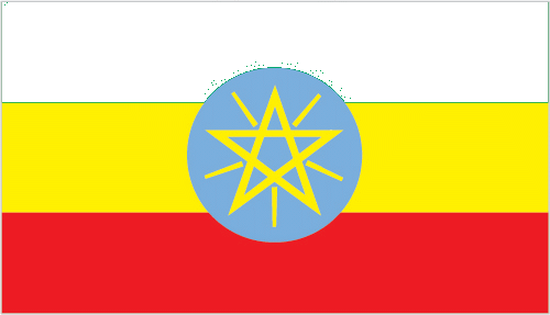
| The national flag of Ethiopia | Borderline map of Ethiopia |
| Flag description: three equal horizontal bands of green (top), yellow, and red, with a yellow pentagram and single yellow rays emanating from the angles between the points on a light blue disk centered on the three bands; green represents hope and the fertility of the land, yellow symbolizes justice and harmony, while red stands for sacrifice and heroism in the defense of the land; the blue of the disk symbolizes peace and the pentagram represents the unity and equality of the nationalities and peoples of Ethiopia. Note: Ethiopia is the oldest independent country in Africa, and the three main colors of her flag (adopted ca. 1895) were so often appropriated by other African countries upon independence that they became known as the Pan-African colors; the emblem in the center of the current flag was added in 1996. | Border length: total: 5,925 km. Border countries (total: 6): Djibouti 342 km, Eritrea 1,033 km, Kenya 867 km, Somalia 1,640 km, South Sudan 1,299 km, Sudan 744 km. |
Did you know about Ethiopia?
- Ethiopia recognized as an empire in the 19th century. It was occupied by Italy from 193641.The Emperor was overthrown in 1974.
- King Solomon and the Queen of Sheba are said to have founded the Kingdom of Abyssinia (Ethiopia) c. 1000 BCE.
- One of the oldest Christian nations on Earth, Ethiopia possesses 11 remarkable cross-shaped churches, each cut out of the solid rock and dating back to the 1200s
Facts of Ethiopia (ET)
Name conventional long form: Federal Democratic Republic of Ethiopia, conventional short form: Ethiopia, local long form: Ityop’iya Federalawi Demokrasiyawi Ripeblik, local short form: Ityop’iya, former: Abyssinia, Italian East Africaabbreviation: FDRE, etymology: the country name derives from the Greek word “Aethiopia,” which in classical times referred to lands south of Egypt in the Upper Nile region
Codes: ISO; ET, Internet; .et
Capital city: Addis Ababa
Language(s): Oromo (official language working language in the State of Oromiya) 33.8%, Amharic (official language national language) 29.3%, Somali (official language working language of the State of Sumale) 6.2%, Tigrigna (Tigrinya) (official language working language of the State of Tigray) 5.9%, Sidamo 4%, Wolaytta 2.2%, Gurage 2%, Afar (official language working language of the State of Afar) 1.7%, Hadiyya 1.7%, Gamo 1.5%, Gedeo 1.3%, Opuuo 1.2%, Kafa 1.1%, other 8.1%, English (major foreign language taught in schools), Arabic (2007 estimate)
National holiday(s): National Day (defeat of MENGISTU regime), 28 May (1991)
Motto: N/A
Currency: Ethiopian birr (ETB), since 1945
GPS: 8 00 N, 38 00 E, Addis Ababa; 9 02 N 38 42 E
Location: Eastern Africa, west of Somalia
Geography note: landlocked – entire coastline along the Red Sea was lost with the de jure independence of Eritrea on 24 May 1993; Ethiopia is, therefore, the most populous landlocked country in the world; the Blue Nile, the chief headstream of the Nile by water volume, rises in T’ana Hayk (Lake Tana) in northwest Ethiopia; three major crops are believed to have originated in Ethiopia: coffee, grain sorghum, and castor bean
Land boundaries: Djibouti 342 km, Eritrea 1,033 km, Kenya 867 km, Somalia 1,640 km, South Sudan 1,299 km, Sudan 744 km, total: 5,925 km
Maritime boundaries: N/A
Coastline: 0 km (landlocked country)
Area: total: 1,104,300 sq km; land: 1 million sq km, water: 104,300 sq km (total 426 372,44 mi2), slightly less than twice the size of Texas.
Roadways: total: 110,414 km, paved: 14,354 km, unpaved: 96,060 km (2015)
Waterways: N/A
Local time (capital): UTC+3, 8 hours ahead of Washington DC during Standard Time
Note to the local time: N/A
Population in Ethiopia: 107 534 882
Population in Addis Ababa: 2 716 200 (including the metropolitan areas)
Urbanization: urban population: 19.5% of total population (2015)
Major urban areas population: ADDIS ABABA (capital) 3.238 million (2015)
Population growth rate: 2.88% (2016 estimate)
Birth rate: 36.9 births / 1,000 population (2016 estimate)
Death rate: 7.9 deaths / 1,000 population (2016 estimate)
Age structure: 0-14 years: 43.71% (male 22,430,798 / female 22,316,910) 15-24 years: 20.04% (male 10,182,973 / female 10,332,626) 25-54 years: 29.45% (male 14,970,645 / female 15,178,999) 55-64 years: 3.89% (male 1,939,635 / female 2,047,041) 65 years and over: 2.91% (male 1,338,985 / female 1,635,432) (2016 estimate)
Median age: total: 17.8 years; male: 17.6 years, female: 18 years (2016 estimate)
Ethnic groups: Oromo 34.4%, Amhara (Amara) 27%, Somali (Somalie) 6.2%, Tigray (Tigrinya) 6.1%, Sidama 4%, Gurage 2.5%, Welaita 2.3%, Hadiya 1.7%, Afar (Affar) 1.7%, Gamo 1.5%, Gedeo 1.3%, Silte 1.3%, Kefficho 1.2%, other 8.8% (2007 estimate)
Religions: Ethiopian Orthodox 43.5%, Muslim 33.9%, Protestant 18.5%, traditional 2.7%, Catholic 0.7%, other 0.6% (2007 estimate)
Government type: Federal parliamentary republic
Legal system: civil law system
National anthem: March Forward, Dear Mother Ethiopia
Known national hazards: geologically active Great Rift Valley susceptible to earthquakes, volcanic eruptions; frequent droughtsvolcanism: volcanic activity in the Great Rift Valley; Erta Ale (elev. 613 m), which has caused frequent lava flows in recent years, is the country’s most active volcano; Dabbahu became active in 2005, forcing evacuations; other historically active volcanoes include Alayta, Dalaffilla, Dallol, Dama Ali, Fentale, Kone, Manda Hararo, and Manda-Inakir
Major infectious diseases: The degree of risk(s): very high food or waterborne diseases: bacterial and protozoal diarrhea, hepatitis A, and typhoid fever vectorborne diseases: malaria and dengue feverrespiratory disease: meningococcal meningitisanimal contact disease: rabieswater contact disease: schistosomiasis (2016)
Land use: agricultural land: 36.3%; arable land 15.2%; permanent crops 1.1%; permanent pasture 20%; forest: 12.2%; other: 51.5% (2011 estimate)
Agricultural products: cereals, coffee, oilseed, cotton, sugarcane, vegetables, khat, cut flowers; hides, cattle, sheep, goats; fish
Industries: food processing, beverages, textiles, leather, garments, chemicals, metals processing, cement
Export commodities: coffee (27%, by value), oilseeds (17%), edible vegetables including khat (17%), gold (13%), flowers (7%), live animals (7%), raw leather products (3%), meat products (3%)
Main export partners: Switzerland 14.3%, China 11.7%, US 9.5%, Netherlands 8.8%, Saudi Arabia 5.9%, Germany 5.7% (2015)
Import commodities: machinery and aircraft (14%, by value), metal and metal products, (14%), electrical materials, (13%), petroleum products (12%), motor vehicles, (10%), chemicals and fertilizers (4%)
Main import partners: China 20.4%, US 9.2%, Saudi Arabia 6.5%, India 4.5% (2015)
Navigate the countries in Africa faster and easier while driving, use the interactive Google maps for your driving directions. The continuously updated database contains over 220 countries and territories digitally mapped, hundreds of millions of businesses and places around the world positioned on the map.
Get fresh GPS navigation, traffic, and transit information – no matter what part of Ethiopia, Addis Ababa, any other city and country in Africa, or the world you’re in.
Do you like this Ethiopia information page? Please don’t forget to share it with others! Thank you.