Guinea Google maps and Driving Directions
Get free driving directions, Google maps, traffic information for Guinea, and Conakry (GPS: 9 30 N 13 42 W), the capital city of the country located in (the) Western Africa, bordering the North Atlantic Ocean, between Guinea-Bissau and Sierra Leone.
Find any address in Conakry on the Google map of Guinea (GN) with ease or calculate your up to date itinerary to and from Guinea or its neighboring counties like Guinea-Bissau, Ivory Coast, Liberia, Mali, Senegal, Sierra Leone.
Sightseeing and exploring in Africa starts here, thanks to Google because its Earth Engine combines a multi-petabyte catalog of updated satellite imagery and geospatial datasets with planetary-scale analysis capabilities. Wonder the world, use the satellite map function of the Google maps to explore or see differences on the Earth’s surface, inland, or the surrounding areas of Guinea.
Google Maps Guinea
Located on the west coast of Africa, Guinea became the first French colony in Africa to gain independence, in 1958. The country was under military rule from 1984 to 1995.
Guinea is generally flat coastal plain, hilly to mountainous interior.
The map above fully covers Guinea with its road routes from cities to towns, road intersections in any region, provinces, prefectures, also with free driving directions in Conakry or to the neighboring towns and countries. To look at the detailed map about a particular quarter in Conakry, please click on the area and zoom to the place you are interested in the Google maps of Guinea (GN).
Be creative, use the extras of this Google map; This is a detailed, clear, zoomable, large road map of Guinea with its administrative divisions; 7 regions administrative and 1 gouvenorat*; Boke, Conakry*, Faranah, Kankan, Kindia, Labe, Mamou, N’Zerekore.
The interactive map above is also may be used as the satellite map of Guinea, or as a reverse search map for finding an address from its GPS coordinates.
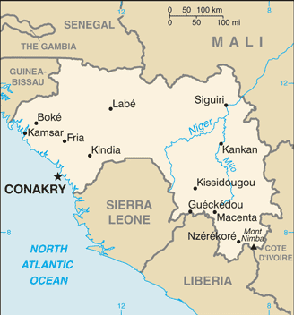
Guinea, in West Africa on the Atlantic, is also bordered by Guinea-Bissau, Senegal, Mali, Côte d’Ivoire, Liberia, and Sierra Leone. Slightly smaller than Oregon, the country consists of a coastal plain, a mountainous region, a savanna interior, and a forest area in the Guinea Highlands. The highest peak is Mount Nimba at 5,748 ft (1,752 m).
Guinea (area: 245 857 sq km / 94 925,88 sq mi), where the official language is French, lying in Africa and using the currency; Guinean franc (GNF), since 1960, set their clock to UTC 0. That means they are 5 hours ahead of Washington DC during Standard Time in Conakry, the capital. Note to the time difference: N/A.
The climate in Guinea; Coastal plains and mangrove swamps in west rise to forested or savanna highlands in the south. Semidesert in the north.
Geography in a nutshell; Coastal plains and mangrove swamps in west rise to forested or savanna highlands in the south. Semidesert in the north.
Click here for more detailed information about Guinea.
Driving directions Guinea
The Google maps and Google Satellite maps of Guinea above showing the country, located next to Guinea-Bissau, Ivory Coast, Liberia, Mali, Senegal, Sierra Leone. For your further reference, the latitude and longitude coordinates of Guinea are 11 00 N, 10 00 W , while the capital, Conakry found at 9 30 N 13 42 W.
When you are traveling around Guinea, Conakry, or its other cities, use this routing tool, providing up to date route planning service free of charge.
Look no further; get accurate driving directions in Guinea, Africa, by filling the route planner form below.
Since Google acquired and introduced its digitalized maps in 2004, you’re probably familiar with its base functions, like finding an address or driving directions to locations. Still, Google maps also accommodate bicyclists, pedestrians, and also public transportation with special directions and customizable routes.
About Guinea and the capital, Conakry
 |
 |
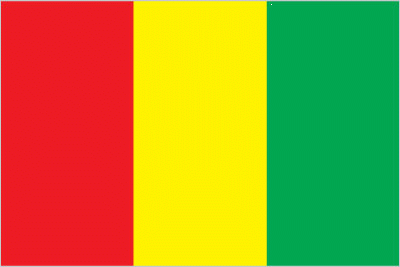
| The national flag of Guinea | Borderline map of Guinea |
| Flag description: three equal vertical bands of red (hoist side), yellow, and green; red represents the people’s sacrifice for liberation and work; yellow stands for the sun, for the riches of the earth, and for justice; green symbolizes the country’s vegetation and unity. Note: uses the popular Pan-African colors of Ethiopia; the colors from left to right are the reverse of those on the flags of neighboring Mali and Senegal. | Border length: total: 4,046 km. Border countries (total: 6): Cote d’Ivoire 816 km, Guinea-Bissau 421 km, Liberia 590 km, Mali 1,062 km, Senegal 363 km, Sierra Leone 794 km. |
Did you know about Guinea?
- In 1958, Guinea became the first territory in former French West Africa to gain independence without first becoming an autonomous republic.
- The colors of Guineas flag represent the three words of the countrys motto: work (red), justice (yellow), and solidarity (green).
- More than 30 per cent of the worlds bauxite-used to make aluminum-is mined in Guinea, as well as gold, diamonds, and iron ore.
Facts of Guinea (GN)
Name conventional long form: Republic of Guinea, conventional short form: Guinea, local long form: Republique de Guinee, local short form: Guinee, former: French Guinea. Note: the country named after the Guinea region of West Africa that lies along the Gulf of Guinea and stretches north to the Sahel
Codes: ISO; GN, Internet; .gn
Capital city: Conakry
Language(s): French (official language). Note: each ethnic group has its own language
National holiday(s): Independence Day, 2 October (1958)
Motto: Travail, Justice, Solidarité (Work, Justice, Solidarity)
Currency: Guinean franc (GNF), since 1960
GPS: 11 00 N, 10 00 W, Conakry; 9 30 N 13 42 W
Location: Western Africa, bordering the North Atlantic Ocean, between Guinea-Bissau and Sierra Leone
Geography note: the Niger and its important tributary the Milo River have their sources in the Guinean highlands
Land boundaries: Cote d’Ivoire 816 km, Guinea-Bissau 421 km, Liberia 590 km, Mali 1,062 km, Senegal 363 km, Sierra Leone 794 km, total: 4,046 km
Maritime boundaries: N/A
Coastline: 320 km
Area: total: 245,857 sq km; land: 245,717 sq km, water: 140 sq km (total 94 925,88 mi2), slightly smaller than Oregon.
Roadways: total: 44,348 km, paved: 4,342 km, unpaved: 40,006 km (2003)
Waterways: 1,300 km (navigable by shallow-draft native craft in the northern part of the Niger River system) (2011)
Local time (capital): UTC 0, 5 hours ahead of Washington DC during Standard Time
Note to the local time: N/A
Population in Guinea: 13 052 608
Population in Conakry: 1 767 200 (including the metropolitan areas)
Urbanization: urban population: 37.2% of total population (2015)
Major urban areas population: CONAKRY (capital) 1.936 million (2015)
Population growth rate: 2.62% (2016 estimate)
Birth rate: 35.4 births / 1,000 population (2016 estimate)
Death rate: 9.2 deaths / 1,000 population (2016 estimate)
Age structure: 0-14 years: 41.7% (male 2,547,037 / female 2,495,495) 15-24 years: 19.67% (male 1,200,618 / female 1,177,633) 25-54 years: 30.52% (male 1,851,200 / female 1,839,952) 55-64 years: 4.46% (male 258,455 / female 281,497) 65 years and over: 3.65% (male 195,054 / female 246,408) (2016 estimate)
Median age: total: 18.8 years; male: 18.6 years, female: 19.1 years (2016 estimate)
Ethnic groups: Fulani (Peul) 33.9%, Malinke 31.1%, Soussou 19.1%, Guerze 6%, Kissi 4.7%, Toma 2.6%, other/no answer 2.7% (2012 estimate)
Religions: Muslim 86.7%, Christian 8.9%, animist/other/none 4.4% (2012 estimate)
Government type: Presidential republic
Legal system: civil law system based on the French model
National anthem: Liberté (Freedom)
Known national hazards: hot, dry, dusty harmattan haze may reduce visibility during dry season
Major infectious diseases: The degree of risk(s): very high food or waterborne diseases: bacterial and protozoal diarrhea, hepatitis A, and typhoid fever vectorborne diseases: malaria, dengue fever, and yellow feverwater contact disease: schistosomiasisaerosolized dust or soil contact disease: Lassa feveranimal contact disease: rabies (2016)
Land use: agricultural land: 58.1%; arable land 11.8%; permanent crops 2.8%; permanent pasture 43.5%; forest: 26.5%; other: 15.4% (2011 estimate)
Agricultural products: rice, coffee, pineapples, mangoes, palm kernels, cocoa, cassava (manioc, tapioca), bananas, potatoes, sweet potatoes; cattle, sheep, goats; timber
Industries: bauxite, gold, diamonds, iron ore; light manufacturing, agricultural processing
Export commodities: bauxite, gold, diamonds, coffee, fish, agricultural products
Main export partners: India 22.5%, Spain 8.2%, Ireland 7.3%, Germany 6.2%, Belgium 5.5%, Ukraine 5.3%, France 4.1% (2015)
Import commodities: petroleum products, metals, machinery, transport equipment, textiles, grain and other foodstuffs
Main import partners: China 20.4%, Netherlands 5.4%, India 4.4% (2015)
Navigate the countries in Africa faster and easier while driving, use the interactive Google maps for your driving directions. The continuously updated database contains over 220 countries and territories digitally mapped, hundreds of millions of businesses and places around the world positioned on the map.
Get fresh GPS navigation, traffic, and transit information – no matter what part of Guinea, Conakry, any other city and country in Africa, or the world you’re in.
Do you like this Guinea information page? Please don’t forget to share it with others! Thank you.