Niger Google maps and Driving Directions
Get free driving directions, Google maps, traffic information for Niger, and Niamey (GPS: 13 31 N 2 07 E), the capital city of the country located in (the) Western Africa, southeast of Algeria.
Find any address in Niamey on the Google map of Niger (NE) with ease or calculate your up to date itinerary to and from Niger or its neighboring counties like Algeria, Benin, Burkina Faso, Chad, Libya, Mali, Nigeria.
Sightseeing and exploring in Africa starts here, thanks to Google because its Earth Engine combines a multi-petabyte catalog of updated satellite imagery and geospatial datasets with planetary-scale analysis capabilities. Wonder the world, use the satellite map function of the Google maps to explore or see differences on the Earth’s surface, inland, or the surrounding areas of Niger.
Google Maps Niger
Niger lies in west Africa, upstream from Nigeria on the Niger River. One of the worlds poorest states, it was ruled by one-party or military regimes until multipartyism was allowed in 1992.
Niger is predominately desert plains and sand dunes; flat to rolling plains in south; hills in north.
The map above fully covers Niger with its road routes from cities to towns, road intersections in any region, provinces, prefectures, also with free driving directions in Niamey or to the neighboring towns and countries. To look at the detailed map about a particular quarter in Niamey, please click on the area and zoom to the place you are interested in the Google maps of Niger (NE).
Be creative, use the extras of this Google map; This is a detailed, clear, zoomable, large road map of Niger with its administrative divisions; 7 regions (regions, singular – region) and 1 capital district* (communite urbaine); Agadez, Diffa, Dosso, Maradi, Niamey*, Tahoua, Tillaberi, Zinder.
The interactive map above is also may be used as the satellite map of Niger, or as a reverse search map for finding an address from its GPS coordinates.
Niger, in West Africa’s Sahara region, is four-fifths the size of Alaska. It is surrounded by Mali, Algeria, Libya, Chad, Nigeria, Benin, and Burkina Faso. The Niger River in the southwest flows through the country’s only fertile area. Elsewhere the land is semiarid. Niger shares borders with seven neighboring countries. In order of shared border length, these are: Nigeria (1,608 km), Chad (1,196 km), Algeria (951 km), Mali (838 km), Burkina Faso (622 km), Libya (342 km), and Benin (277 km).
Niger (area: 1 267 000 sq km / 489 191,23 sq mi), where the official language is French, lying in Africa and using the currency; West African CFA franc (XOF), set their clock to UTC+1. That means they are 6 hours ahead of Washington DC during Standard Time in Niamey, the capital. Note to the time difference: N/A.
The climate in Niger; High temperatures persist for most of the year at around 95°F (35°C). The north is virtually rainless.
Geography in a nutshell; The north and northeast regions are part of the Sahara. The A?r Mountains in the center rise high above the desert. Savanna lies to the south.
Click here for more detailed information about Niger.
Driving directions Niger
The Google maps and Google Satellite maps of Niger above showing the country, located next to Algeria, Benin, Burkina Faso, Chad, Libya, Mali, Nigeria. For your further reference, the latitude and longitude coordinates of Niger are 16 00 N, 8 00 E , while the capital, Niamey found at 13 31 N 2 07 E.
When you are traveling around Niger, Niamey, or its other cities, use this routing tool, providing up to date route planning service free of charge.
Look no further; get accurate driving directions in Niger, Africa, by filling the route planner form below.
Since Google acquired and introduced its digitalized maps in 2004, you’re probably familiar with its base functions, like finding an address or driving directions to locations. Still, Google maps also accommodate bicyclists, pedestrians, and also public transportation with special directions and customizable routes.
About Niger and the capital, Niamey
 |
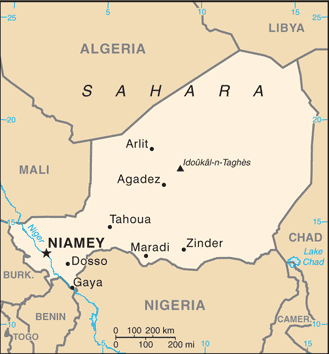 |
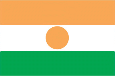
| The national flag of Niger | Borderline map of Niger |
| Flag description: three equal horizontal bands of orange (top), white, and green with a small orange disk centered in the white band; the orange band denotes the drier northern regions of the Sahara; white stands for purity and innocence; green symbolizes hope and the fertile and productive southern and western areas, as well as the Niger River; the orange disc represents the sun and the sacrifices made by the people. Note: similar to the flag of India, which has a blue spoked wheel centered in the white band. | Border length: total: 5,834 km. Border countries (total: 7): Algeria 951 km, Benin 277 km, Burkina Faso 622 km, Chad 1,196 km, Libya 342 km, Mali 838 km, Nigeria 1,608 km. |
Did you know about Niger?
- Niger was originally a province of French West Africa. In 1958 it joined the Sahel-Benin Union, achieving full independence in 1960.
- The name Niger comes from the Tuareg word neghirren, which means “flowing water.
- Large reserves of uranium, the fuel used to make nuclear power, are mined in Niger.
Facts of Niger (NE)
Name conventional long form: Republic of Niger, conventional short form: Niger, local long form: Republique du Niger, local short form: Niger, etymology: named for the Niger River that passes through the southwest of the country; from a native term “Ni Gir” meaning “River Gir”
Codes: ISO; NE, Internet; .ne
Capital city: Niamey
Language(s): French (official language), Hausa, Djerma
National holiday(s): Republic Day, 18 December (1958)
Motto: Fraternité, travail, Progrés (Fraternity, Work, Progress)
Currency: West African CFA franc (XOF)
GPS: 16 00 N, 8 00 E, Niamey; 13 31 N 2 07 E
Location: Western Africa, southeast of Algeria
Geography note: landlocked country; one of the hottest countries in the world; northern four-fifths is desert, southern one-fifth is savanna, suitable for livestock and limited agriculture
Land boundaries: Algeria 951 km, Benin 277 km, Burkina Faso 622 km, Chad 1,196 km, Libya 342 km, Mali 838 km, Nigeria 1,608 km, total: 5,834 km
Maritime boundaries: N/A
Coastline: 0 km (landlocked country)
Area: total: 1.267 million sq km; land: 1,266,700 sq km, water: 300 sq km (total 489 191,23 mi2), slightly less than twice the size of Texas.
Roadways: total: 18,949 km, paved: 3,912 km, unpaved: 15,037 km (2010)
Waterways: 300 km (the Niger, the only major river, is navigable to Gaya between September and March) (2012)
Local time (capital): UTC+1, 6 hours ahead of Washington DC during Standard Time
Note to the local time: N/A
Population in Niger: 22 311 375
Population in Niamey: 748 600 (including the metropolitan areas)
Urbanization: urban population: 18.7% of total population (2015)
Major urban areas population: NIAMEY (capital) 1.09 million (2015)
Population growth rate: 3.22% (2016 estimate)
Birth rate: 44.8 births / 1,000 population (2016 estimate)
Death rate: 12.1 deaths / 1,000 population (2016 estimate)
Age structure: 0-14 years: 49.31% (male 4,635,901 / female 4,554,010) 15-24 years: 18.85% (male 1,734,887 / female 1,777,896) 25-54 years: 25.94% (male 2,414,668 / female 2,419,725) 55-64 years: 3.27% (male 316,655 / female 293,570) 65 years and over: 2.64% (male 250,314 / female 240,974) (2016 estimate)
Median age: total: 15.3 years; male: 15.2 years, female: 15.4 years (2016 estimate)
Ethnic groups: Hausa 53.1%, Zarma/Songhai 21.2%, Tuareg 11%, Fulani (Peul) 6.5%, Kanuri 5.9%, Gurma 0.8%, Arab 0.4%, Tubu 0.4%, other/unavailable 0.9% (2006 estimate)
Religions: Muslim 80%, other (includes indigenous beliefs and Christian) 20%
Government type: Unitary semi-presidential republic
Legal system: mixed legal system of civil law (based on French civil law), Islamic law, and customary law
National anthem: La Nigérienne
Known national hazards: recurring droughts
Major infectious diseases: The degree of risk(s): very high food or waterborne diseases: bacterial and protozoal diarrhea, hepatitis A, and typhoid fever vectorborne diseases: malaria and dengue feverwater contact disease: schistosomiasisrespiratory disease: meningococcal meningitisanimal contact disease: rabies (2016)
Land use: agricultural land: 35.1%; arable land 12.3%; permanent crops 0.1%; permanent pasture 22.7%; forest: 1%; other: 63.9% (2011 estimate)
Agricultural products: cowpeas, cotton, peanuts, millet, sorghum, cassava (manioc, tapioca), rice; cattle, sheep, goats, camels, donkeys, horses, poultry
Industries: uranium mining, petroleum, cement, brick, soap, textiles, food processing, chemicals, slaughterhouses
Export commodities: uranium ore, livestock, cowpeas, onions
Main export partners: France 53.1%, Nigeria 20.3%, China 13.8% (2015)
Import commodities: foodstuffs, machinery, vehicles and parts, petroleum, cereals
Main import partners: France 12%, China 10.5%, Nigeria 9.5%, French Polynesia 9%, Togo 6.1%, Belgium 5.3%, Cote dIvoire 5.3%, US 4.3% (2015)
Navigate the countries in Africa faster and easier while driving, use the interactive Google maps for your driving directions. The continuously updated database contains over 220 countries and territories digitally mapped, hundreds of millions of businesses and places around the world positioned on the map.
Get fresh GPS navigation, traffic, and transit information – no matter what part of Niger, Niamey, any other city and country in Africa, or the world you’re in.
Do you like this Niger information page? Please don’t forget to share it with others! Thank you.