Liberia Google maps and Driving Directions
Get free driving directions, Google maps, traffic information for Liberia, and Monrovia (GPS: 6 18 N 10 48 W), the capital city of the country located in (the) Western Africa, bordering the North Atlantic Ocean, between Cote d’Ivoire and Sierra Leone.
Find any address in Monrovia on the Google map of Liberia (LR) with ease or calculate your up to date itinerary to and from Liberia or its neighboring counties like Guinea, Ivory Coast, Sierra Leone.
Sightseeing and exploring in Africa starts here, thanks to Google because its Earth Engine combines a multi-petabyte catalog of updated satellite imagery and geospatial datasets with planetary-scale analysis capabilities. Wonder the world, use the satellite map function of the Google maps to explore or see differences on the Earth’s surface, inland, or the surrounding areas of Liberia.
Google Maps Liberia
Liberia, on Africas Atlantic coast, was founded as a republic of freed slaves. A brutal coup in 1980 and years of civil war have left gang violence and looting widespread.
Liberia is mostly flat to rolling coastal plains rising to rolling plateau and low mountains in northeast.
The map above fully covers Liberia with its road routes from cities to towns, road intersections in any region, provinces, prefectures, also with free driving directions in Monrovia or to the neighboring towns and countries. To look at the detailed map about a particular quarter in Monrovia, please click on the area and zoom to the place you are interested in the Google maps of Liberia (LR).
Be creative, use the extras of this Google map; This is a detailed, clear, zoomable, large road map of Liberia with its administrative divisions; 15 counties; Bomi, Bong, Gbarpolu, Grand Bassa, Grand Cape Mount, Grand Gedeh, Grand Kru, Lofa, Margibi, Maryland, Montserrado, Nimba, River Cess, River Gee, Sinoe.
The interactive map above is also may be used as the satellite map of Liberia, or as a reverse search map for finding an address from its GPS coordinates.
Lying on the Atlantic in the southern part of West Africa, Liberia is bordered by Sierra Leone, Guinea, and Côte d’Ivoire. It is comparable in size to Tennessee. Most of the country is a plateau covered by dense tropical forests, which thrive under an annual rainfall of about 160 in. a year.
Liberia (area: 111 369 sq km / 42 999,79 sq mi), where the official language is English, lying in Africa and using the currency; Liberian dollar (LRD), since 1943, set their clock to UTC 0. That means they are 5 hours ahead of Washington DC during Standard Time in Monrovia, the capital. Note to the time difference: N/A.
The climate in Liberia; High temperatures. There is only one wet season, from May to October, except in the extreme southeast.
Geography in a nutshell; A coastline of beaches and mangrove swamps rises to forested plateaus and highlands inland.
Click here for more detailed information about Liberia.
Driving directions Liberia
The Google maps and Google Satellite maps of Liberia above showing the country, located next to Guinea, Ivory Coast, Sierra Leone. For your further reference, the latitude and longitude coordinates of Liberia are 6 30 N, 9 30 W , while the capital, Monrovia found at 6 18 N 10 48 W.
When you are traveling around Liberia, Monrovia, or its other cities, use this routing tool, providing up to date route planning service free of charge.
Look no further; get accurate driving directions in Liberia, Africa, by filling the route planner form below.
Since Google acquired and introduced its digitalized maps in 2004, you’re probably familiar with its base functions, like finding an address or driving directions to locations. Still, Google maps also accommodate bicyclists, pedestrians, and also public transportation with special directions and customizable routes.
About Liberia and the capital, Monrovia
 |
 |
| The national flag of Liberia | Borderline map of Liberia |
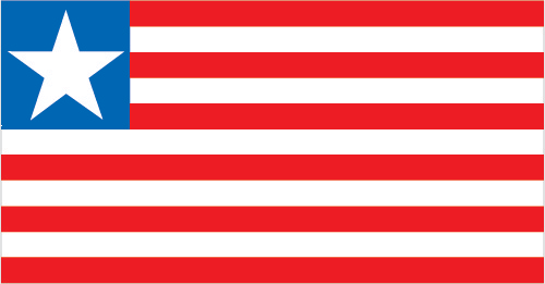
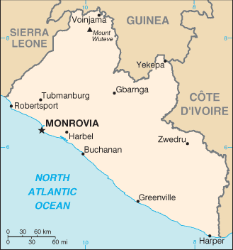
| Flag description: 11 equal horizontal stripes of red (top and bottom) alternating with white; a white five-pointed star appears on a blue square in the upper hoist-side corner; the stripes symbolize the signatories of the Liberian Declaration of Independence; the blue square represents the African mainland, and the star represents the freedom granted to the ex-slaves; according to the constitution, the blue color signifies liberty, justice, and fidelity, the white color purity, cleanliness, and guilelessness, and the red color steadfastness, valor, and fervor. Note: the design is based on the US flag. | Border length: total: 1,667 km. Border countries (total: 3): Guinea 590 km, Cote d’Ivoire 778 km, Sierra Leone 299 km. |
Did you know about Liberia?
- Liberia founded in 1816 by the American Colonization Society as a home for freed slaves from the USA. It became independent in 1847.
- Liberia is named after the people liberated from slavery who arrived from the US in the 1800s.
- Founded in 1847 as a home for freed U.S. slaves returning to Africa, Liberia has plantations of rubber trees that are tapped for their latex-the sap that is used to make rubber.
Facts of Liberia (LR)
Name conventional long form: Republic of Liberia, conventional short form: Liberia, etymology: name derives from the Latin word “liber” meaning “free”; so named because the nation was created as a homeland for liberated African-American slaves
Codes: ISO; LR, Internet; .lr
Capital city: Monrovia
Language(s): English 20% (official language), some 20 ethnic group languages few of which can be written or used in correspondence
National holiday(s): Independence Day, 26 July (1847)
Motto: The love of liberty brought us here
Currency: Liberian dollar (LRD), since 1943
GPS: 6 30 N, 9 30 W, Monrovia; 6 18 N 10 48 W
Location: Western Africa, bordering the North Atlantic Ocean, between Cote d’Ivoire and Sierra Leone
Geography note: facing the Atlantic Ocean, the coastline is characterized by lagoons, mangrove swamps, and river-deposited sandbars; the inland grassy plateau supports limited agriculture
Land boundaries: Guinea 590 km, Cote d’Ivoire 778 km, Sierra Leone 299 km, total: 1,667 km
Maritime boundaries: N/A
Coastline: 579 km
Area: total: 111,369 sq km; land: 96,320 sq km, water: 15,049 sq km (total 42 999,79 mi2), slightly larger than Tennessee.
Roadways: total: 10,600 km, paved: 657 km, unpaved: 9,943 km (2000)
Waterways: N/A
Local time (capital): UTC 0, 5 hours ahead of Washington DC during Standard Time
Note to the local time: N/A
Population in Liberia: 4 853 516
Population in Monrovia: 1 348 900 (including the metropolitan areas)
Urbanization: urban population: 49.7% of total population (2015)
Major urban areas population: MONROVIA (capital) 1.264 million (2015)
Population growth rate: 2.44% (2016 estimate)
Birth rate: 33.9 births / 1,000 population (2016 estimate)
Death rate: 9.5 deaths / 1,000 population (2016 estimate)
Age structure: 0-14 years: 42.3% (male 917,354 / female 901,627) 15-24 years: 18.9% (male 400,013 / female 412,869) 25-54 years: 31.32% (male 669,630 / female 677,321) 55-64 years: 4.3% (male 89,264 / female 95,519) 65 years and over: 3.17% (male 66,658 / female 69,689) (2016 estimate)
Median age: total: 18.3 years; male: 18.1 years, female: 18.5 years (2016 estimate)
Ethnic groups: Kpelle 20.3%, Bassa 13.4%, Grebo 10%, Gio 8%, Mano 7.9%, Kru 6%, Lorma 5.1%, Kissi 4.8%, Gola 4.4%, other 20.1% (2008 Census)
Religions: Christian 85.6%, Muslim 12.2%, Traditional 0.6%, other 0.2%, none 1.4% (2008 Census)
Government type: Unitary presidential republic
Legal system: mixed legal system of common law (based on Anglo-American law) and customary law
National anthem: All Hail, Liberia, Hail!
Known national hazards: dust-laden harmattan winds blow from the Sahara (December to March)
Major infectious diseases: The degree of risk(s): very high food or waterborne diseases: bacterial and protozoal diarrhea, hepatitis A, and typhoid fever vectorborne diseases: malaria, dengue fever, and yellow feverwater contact disease: schistosomiasisaerosolized dust or soil contact disease: Lassa feveranimal contact disease: rabies (2016)
Land use: agricultural land: 28.1%; arable land 5.2%; permanent crops 2.1%; permanent pasture 20.8%; forest: 44.6%; other: 27.3% (2011 estimate)
Agricultural products: rubber, coffee, cocoa, rice, cassava (manioc, tapioca), palm oil, sugarcane, bananas; sheep, goats; timber
Industries: mining (iron ore), rubber processing, palm oil processing, timber, diamonds
Export commodities: rubber, timber, iron, diamonds, cocoa, coffee
Main export partners: Poland 32.9%, China 20.7%, India 9.3%, US 5.1%, Greece 4.7%, France 4.3% (2015)
Import commodities: fuels, chemicals, machinery, transportation equipment, manufactured goods; foodstuffs
Main import partners: Singapore 28.7%, China 16%, South Korea 15.3%, Japan 10.3%, Philippines 6.6% (2015)
Navigate the countries in Africa faster and easier while driving, use the interactive Google maps for your driving directions. The continuously updated database contains over 220 countries and territories digitally mapped, hundreds of millions of businesses and places around the world positioned on the map.
Get fresh GPS navigation, traffic, and transit information – no matter what part of Liberia, Monrovia, any other city and country in Africa, or the world you’re in.
Do you like this Liberia information page? Please don’t forget to share it with others! Thank you.