Sierra Leone Google maps and Driving Directions
Get free driving directions, Google maps, traffic information for Sierra Leone, and Freetown (GPS: 8 29 N 13 14 W), the capital city of the country located in (the) Western Africa, bordering the North Atlantic Ocean, between Guinea and Liberia.
Find any address in Freetown on the Google map of Sierra Leone (SL) with ease or calculate your up to date itinerary to and from Sierra Leone or its neighboring counties like Guinea, Liberia.
Sightseeing and exploring in Africa starts here, thanks to Google because its Earth Engine combines a multi-petabyte catalog of updated satellite imagery and geospatial datasets with planetary-scale analysis capabilities. Wonder the world, use the satellite map function of the Google maps to explore or see differences on the Earth’s surface, inland, or the surrounding areas of Sierra Leone.
Google Maps Sierra Leone
The west African state of Sierra Leone achieved independence from the UK in 1961. Today, trying to recover from ten years of devastating civil war, it is one of the worlds poorest nations.
Sierra Leone is coastal belt of mangrove swamps, wooded hill country, upland plateau, mountains in east.
The map above fully covers Sierra Leone with its road routes from cities to towns, road intersections in any region, provinces, prefectures, also with free driving directions in Freetown or to the neighboring towns and countries. To look at the detailed map about a particular quarter in Freetown, please click on the area and zoom to the place you are interested in the Google maps of Sierra Leone (SL).
Be creative, use the extras of this Google map; This is a detailed, clear, zoomable, large road map of Sierra Leone with its administrative divisions; 3 provinces and 1 area*; Eastern, Northern, Southern, Western*.
The interactive map above is also may be used as the satellite map of Sierra Leone, or as a reverse search map for finding an address from its GPS coordinates.
Sierra Leone, on the Atlantic Ocean in West Africa, is half the size of Illinois. Guinea, in the north and east, and Liberia, in the south, are its neighbors. Mangrove swamps lie along the coast, with wooded hills and a plateau in the interior. The eastern region is mountainous.
Sierra Leone (area: 71 740 sq km / 27 698,96 sq mi), where the official language is English, lying in Africa and using the currency; Sierra Leonean leone (SLL), since 1964, set their clock to UTC 0. That means they are 5 hours ahead of Washington DC during Standard Time in Freetown, the capital. Note to the time difference: N/A.
The climate in Sierra Leone; Hot tropical weather, with very high rainfall and humidity. The dusty, northeastern harmattan wind blows NovemberApril.
Geography in a nutshell; Flat plain, running the length of the coast, stretches inland for 83 miles (133 km). Beyond, forests rise to highlands near neighboring Guinea in the northeast.
Click here for more detailed information about Sierra Leone.
Driving directions Sierra Leone
The Google maps and Google Satellite maps of Sierra Leone above showing the country, located next to Guinea, Liberia. For your further reference, the latitude and longitude coordinates of Sierra Leone are 8 30 N, 11 30 W , while the capital, Freetown found at 8 29 N 13 14 W.
When you are traveling around Sierra Leone, Freetown, or its other cities, use this routing tool, providing up to date route planning service free of charge.
Look no further; get accurate driving directions in Sierra Leone, Africa, by filling the route planner form below.
Since Google acquired and introduced its digitalized maps in 2004, you’re probably familiar with its base functions, like finding an address or driving directions to locations. Still, Google maps also accommodate bicyclists, pedestrians, and also public transportation with special directions and customizable routes.
About Sierra Leone and the capital, Freetown
 |
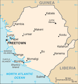 |
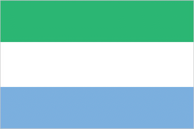
| The national flag of Sierra Leone | Borderline map of Sierra Leone |
| Flag description: three equal horizontal bands of green (top), white, and blue; green symbolizes agriculture, mountains, and natural resources, white represents unity and justice, and blue the sea and the natural harbor in Freetown. | Border length: total: 1,093 km. Border countries (total: 2): Guinea 794 km, Liberia 299 km. |
Did you know about Sierra Leone?
- Sierra Leone founded as a home for freed slaves in 1787, but became a British colony in 1808. It achieved independence in 1961.
- The British philanthropist Granville Sharp set up a settlement for freed slaves in Freetown in 1787.
- Rich in diamonds, Sierra Leone provides many of the gems used in engagement rings and other pieces of jewelry.
Facts of Sierra Leone (SL)
Name conventional long form: Republic of Sierra Leone, conventional short form: Sierra Leone, local long form: Republic of Sierra Leone, local short form: Sierra Leone, etymology: the Portuguese explorer Pedro de SINTRA named the country “Serra Leoa” (Lion Mountains) for the impressive mountains he saw while sailing the West African coast in 1462
Codes: ISO; SL, Internet; .sl
Capital city: Freetown
Language(s): English (official language, regular use limited to literate minority), Mende (principal vernacular in the south), Temne (principal vernacular in the north), Krio (English-based Creole, spoken by the descendants of freed Jamaican slaves who were settled in the Freetown area, a lingua franca and a first language for 10% of the population but understood by 95%)
National holiday(s): Independence Day, 27 April (1961)
Motto: Unity, Freedom, Justice
Currency: Sierra Leonean leone (SLL), since 1964
GPS: 8 30 N, 11 30 W, Freetown; 8 29 N 13 14 W
Location: Western Africa, bordering the North Atlantic Ocean, between Guinea and Liberia
Geography note: rainfall along the coast can reach 495 cm (195 inches) a year, making it one of the wettest places along coastal, western Africa
Land boundaries: Guinea 794 km, Liberia 299 km, total: 1,093 km
Maritime boundaries: N/A
Coastline: 402 km
Area: total: 71,740 sq km; land: 71,620 sq km, water: 120 sq km (total 27 698,96 mi2), slightly smaller than South Carolina.
Roadways: total: 11,300 km, paved: 904 km, unpaved: 10,396 km (2002)
Waterways: 800 km (600 km navigable year round) (2011)
Local time (capital): UTC 0, 5 hours ahead of Washington DC during Standard Time
Note to the local time: N/A
Population in Sierra Leone: 7 719 729
Population in Freetown: 941 000 (including the metropolitan areas)
Urbanization: urban population: 39.9% of total population (2015)
Major urban areas population: FREETOWN (capital) 1.007 million (2015)
Population growth rate: 2.36% (2016 estimate)
Birth rate: 36.7 births / 1,000 population (2016 estimate)
Death rate: 10.6 deaths / 1,000 population (2016 estimate)
Age structure: 0-14 years: 41.9% (male 1,257,997 / female 1,263,961) 15-24 years: 18.57% (male 542,975 / female 574,669) 25-54 years: 32.04% (male 924,331 / female 1,003,895) 55-64 years: 3.74% (male 104,415 / female 120,953) 65 years and over: 3.75% (male 94,520 / female 131,172) (2016 estimate)
Median age: total: 19 years; male: 18.4 years, female: 19.6 years (2016 estimate)
Ethnic groups: Temne 35%, Mende 31%, Limba 8%, Kono 5%, Kriole 2% (descendants of freed Jamaican slaves who were settled in the Freetown area in the late-18th century; also known as Krio), Mandingo 2%, Loko 2%, other 15% (includes refugees from Liberia‘s recent civil war, and small numbers of Europeans, Lebanese, Pakistanis, and Indians) (2008 census)
Religions: Muslim 60%, Christian 10%, indigenous beliefs 30%
Government type: Unitary presidential constitutional republic
Legal system: mixed legal system of English common law and customary law
National anthem: High We Exalt Thee, Realm of the Free
Known national hazards: dry, sand-laden harmattan winds blow from the Sahara (December to February); sandstorms, dust storms
Major infectious diseases: The degree of risk(s): very high food or waterborne diseases: bacterial and protozoal diarrhea, hepatitis A, and typhoid fever vectorborne diseases: malaria, dengue fever, and yellow feverwater contact disease: schistosomiasis animal contact disease: rabiesaerosolized dust or soil contact disease: Lassa fever (2016)
Land use: agricultural land: 56.2%; arable land 23.4%; permanent crops 2.3%; permanent pasture 30.5%; forest: 37.5%; other: 6.3% (2011 estimate)
Agricultural products: rice, coffee, cocoa, palm kernels, palm oil, peanuts, cashews; poultry, cattle, sheep, pigs; fish
Industries: diamond mining; iron ore, rutile and bauxite mining; small-scale manufacturing (beverages, textiles, footwear)
Export commodities: Iron ore, diamonds, rutile, cocoa, coffee, fish
Main export partners: China 31.3%, Belgium 27.8%, Romania 11.3%, US 7.3%, India 4% (2015)
Import commodities: foodstuffs, machinery and equipment, fuels and lubricants, chemicals
Main import partners: China 23%, India 7.9%, US 6.4%, Netherlands 5.1% (2015)
Navigate the countries in Africa faster and easier while driving, use the interactive Google maps for your driving directions. The continuously updated database contains over 220 countries and territories digitally mapped, hundreds of millions of businesses and places around the world positioned on the map.
Get fresh GPS navigation, traffic, and transit information – no matter what part of Sierra Leone, Freetown, any other city and country in Africa, or the world you’re in.
Do you like this Sierra Leone information page? Please don’t forget to share it with others! Thank you.