Senegal Google maps and Driving Directions
Get free driving directions, Google maps, traffic information for Senegal, and Dakar (GPS: 14 44 N 17 38 W), the capital city of the country located in (the) Western Africa, bordering the North Atlantic Ocean, between Guinea-Bissau and Mauritania.
Find any address in Dakar on the Google map of Senegal (SN) with ease or calculate your up to date itinerary to and from Senegal or its neighboring counties like Gambia, Guinea, Guinea-Bissau, Mali, Mauritania.
Sightseeing and exploring in Africa starts here, thanks to Google because its Earth Engine combines a multi-petabyte catalog of updated satellite imagery and geospatial datasets with planetary-scale analysis capabilities. Wonder the world, use the satellite map function of the Google maps to explore or see differences on the Earth’s surface, inland, or the surrounding areas of Senegal.
Google Maps Senegal
Senegals capital, Dakar, stands on the westernmost cape of Africa. After independence from France, Senegal became a single-party state, but it has had multiparty elections since 1981.
Senegal is generally low, rolling, plains rising to foothills in southeast.
The map above fully covers Senegal with its road routes from cities to towns, road intersections in any region, provinces, prefectures, also with free driving directions in Dakar or to the neighboring towns and countries. To look at the detailed map about a particular quarter in Dakar, please click on the area and zoom to the place you are interested in the Google maps of Senegal (SN).
Be creative, use the extras of this Google map; This is a detailed, clear, zoomable, large road map of Senegal with its administrative divisions; 14 regions (regions, singular – region); Dakar, Diourbel, Fatick, Kaffrine, Kaolack, Kedougou, Kolda, Louga, Matam, Saint-Louis, Sedhiou, Tambacounda, Thies, Ziguinchor.
The interactive map above is also may be used as the satellite map of Senegal, or as a reverse search map for finding an address from its GPS coordinates.
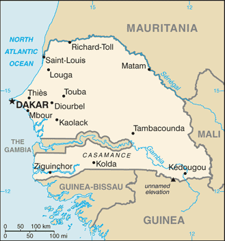
The capital of Senegal, Dakar, is the westernmost point in Africa. The country, slightly smaller than South Dakota, surrounds Gambia on three sides and is bordered on the north by Mauritania, on the east by Mali, and on the south by Guinea and Guinea-Bissau. Senegal is mainly a low-lying country, with a semidesert area in the north and northeast and forests in the southwest. The largest rivers include the Senegal in the north and the Casamance in the southern tropical climate region.
Senegal (area: 196 722 sq km / 75 954,76 sq mi), where the official language is French, lying in Africa and using the currency; West African CFA franc (XOF), set their clock to UTC 0. That means they are 5 hours ahead of Washington DC during Standard Time in Dakar, the capital. Note to the time difference: N/A.
The climate in Senegal; Tropical, with humid rainy conditions JuneOctober, and a drier season DecemberMay. The coast is cooled by northern trade winds.
Geography in a nutshell; Arid semidesert in the north. The south is mainly savanna bushland. Plains in the southeast.
Click here for more detailed information about Senegal.
Driving directions Senegal
The Google maps and Google Satellite maps of Senegal above showing the country, located next to Gambia, Guinea, Guinea-Bissau, Mali, Mauritania. For your further reference, the latitude and longitude coordinates of Senegal are 14 00 N, 14 00 W , while the capital, Dakar found at 14 44 N 17 38 W.
When you are traveling around Senegal, Dakar, or its other cities, use this routing tool, providing up to date route planning service free of charge.
Look no further; get accurate driving directions in Senegal, Africa, by filling the route planner form below.
Since Google acquired and introduced its digitalized maps in 2004, you’re probably familiar with its base functions, like finding an address or driving directions to locations. Still, Google maps also accommodate bicyclists, pedestrians, and also public transportation with special directions and customizable routes.
About Senegal and the capital, Dakar
 |
 |
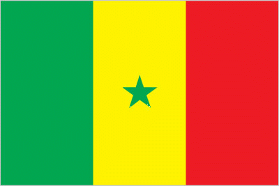
| The national flag of Senegal | Borderline map of Senegal |
| Flag description: three equal vertical bands of green (hoist side), yellow, and red with a small green five-pointed star centered in the yellow band; green represents Islam, progress, and hope; yellow signifies natural wealth and progress; red symbolizes sacrifice and determination; the star denotes unity and hope. Note: uses the popular Pan-African colors of Ethiopia; the colors from left to right are the same as those of neighboring Mali and the reverse of those on the flag of neighboring Guinea. | Border length: total: 2,684 km. Border countries (total: 5): The Gambia 749 km, Guinea 363 km, Guinea-Bissau 341 km, Mali 489 km, Mauritania 742 km. |
Did you know about Senegal?
- Senegal achieved independence from France in federation with Mali in June 1960. The Federation lasted until August 1960.
- Senegals name derives from the Muslim Zenega Berbers who invaded in the 1300s.
- Local griots (tribal storytellers) relate stories of past events accompanied by the kora-a 21-stringed instrument with a soundbox made from a gourd.
Facts of Senegal (SN)
Name conventional long form: Republic of Senegal, conventional short form: Senegal, local long form: Republique du Senegal, local short form: Senegal, former: Senegambia (along with The Gambia), Mali Federation, etymology: named for the Senegal River that forms the northern border of the country; many theories exist for the origin of the river name; perhaps the most widely cited derives the name from “Azenegue,” the Portuguese appellation for the Berber Zenaga people who lived north of the river
Codes: ISO; SN, Internet; .sn
Capital city: Dakar
Language(s): French (official language), Wolof, Pulaar, Jola, Mandinka
National holiday(s): Independence Day, 4 April (1960)
Motto: Un Peuple, Un But, Une Foi (One People, One Goal, One Faith)
Currency: West African CFA franc (XOF)
GPS: 14 00 N, 14 00 W, Dakar; 14 44 N 17 38 W
Location: Western Africa, bordering the North Atlantic Ocean, between Guinea-Bissau and Mauritania
Geography note: westernmost country on the African continent; The Gambia is almost an enclave within Senegal
Land boundaries: The Gambia 749 km, Guinea 363 km, Guinea-Bissau 341 km, Mali 489 km, Mauritania 742 km, total: 2,684 km
Maritime boundaries: N/A
Coastline: 531 km
Area: total: 196,722 sq km; land: 192,530 sq km, water: 4,192 sq km (total 75 954,76 mi2), slightly smaller than South Dakota.
Roadways: total: 15,000 km, paved: 5,300 km (includes 7 km of expressways), unpaved: 9,700 km (2015)
Waterways: 1,000 km (primarily on the Senegal, Saloum, and Casamance Rivers) (2012)
Local time (capital): UTC 0, 5 hours ahead of Washington DC during Standard Time
Note to the local time: N/A
Population in Senegal: 16 294 270
Population in Dakar: 3 035 000 (including the metropolitan areas)
Urbanization: urban population: 43.7% of total population (2015)
Major urban areas population: DAKAR (capital) 3.52 million (2015)
Population growth rate: 2.42% (2016 estimate)
Birth rate: 34 births / 1,000 population (2016 estimate)
Death rate: 8.3 deaths / 1,000 population (2016 estimate)
Age structure: 0-14 years: 41.85% (male 3,011,233 / female 2,981,128) 15-24 years: 20.36% (male 1,452,415 / female 1,462,989) 25-54 years: 30.93% (male 2,031,035 / female 2,398,788) 55-64 years: 3.91% (male 242,429 / female 317,439) 65 years and over: 2.95% (male 189,201 / female 233,398) (2016 estimate)
Median age: total: 18.7 years; male: 17.8 years, female: 19.6 years (2016 estimate)
Ethnic groups: Wolof 38.7%, Pular 26.5%, Serer 15%, Mandinka 4.2%, Jola 4%, Soninke 2.3%, other 9.3% (includes Europeans and persons of Lebanese descent) (2010-11 estimate)
Religions: Muslim 95.4% (most adhere to one of the four main Sufi brotherhoods), Christian 4.2% (mostly Roman Catholic), animist 0.4% (2010-11 estimate)
Government type: Semi-presidential republic
Legal system: civil law system based on French law; judicial review of legislative acts in Constitutional Court
National anthem: Le Lion rouge (The red lion)
Known national hazards: lowlands seasonally flooded; periodic droughts
Major infectious diseases: The degree of risk(s): very high food or waterborne diseases: bacterial and protozoal diarrhea, hepatitis A, and typhoid fever vectorborne diseases: malaria and dengue feverwater contact disease: schistosomiasisrespiratory disease: meningococcal meningitisanimal contact disease: rabies (2016)
Land use: agricultural land: 46.8%; arable land 17.4%; permanent crops 0.3%; permanent pasture 29.1%; forest: 43.8%; other: 9.4% (2011 estimate)
Agricultural products: peanuts, millet, corn, sorghum, rice, cotton, tomatoes, green vegetables; cattle, poultry, pigs; fish
Industries: agricultural and fish processing, phosphate mining, fertilizer production, petroleum refining, zircon, and gold mining, construction materials, ship construction and repair
Export commodities: fish, groundnuts (peanuts), petroleum products, phosphates, cotton
Main export partners: Mali 12.8%, Switzerland 9.7%, India 5.9%, Cote dIvoire 5.3%, China 5.1%, UAE 4.1%, France 4.1% (2015)
Import commodities: food and beverages, capital goods, fuels
Main import partners: France 17.9%, China 10%, Nigeria 8.7%, India 5.6%, Spain 4.9%, Netherlands 4.5% (2015)
Navigate the countries in Africa faster and easier while driving, use the interactive Google maps for your driving directions. The continuously updated database contains over 220 countries and territories digitally mapped, hundreds of millions of businesses and places around the world positioned on the map.
Get fresh GPS navigation, traffic, and transit information – no matter what part of Senegal, Dakar, any other city and country in Africa, or the world you’re in.
Do you like this Senegal information page? Please don’t forget to share it with others! Thank you.