Israel Google maps and Driving Directions
Get free driving directions, Google maps, traffic information for Israel, and Jerusalem (GPS: 31 46 N 35 14 E), the capital city of the country located in (the) Middle East, bordering the Mediterranean Sea, between Egypt and Lebanon.
Find any address in Jerusalem on the Google map of Israel (IL) with ease or calculate your up to date itinerary to and from Israel or its neighboring counties like Egypt, Jordan, Lebanon, Palestine, Syria.
Sightseeing and exploring in Asia starts here, thanks to Google because its Earth Engine combines a multi-petabyte catalog of updated satellite imagery and geospatial datasets with planetary-scale analysis capabilities. Wonder the world, use the satellite map function of the Google maps to explore or see differences on the Earth’s surface, inland, or the surrounding areas of Israel.
Google Maps Israel
Created as a new state in 1948, Israel lies on the eastern Mediterranean. The current phase of the Palestinian intifada (armed struggle) against Israeli occupation began in 2000.
Israel is Negev desert in the south; low coastal plain; central mountains; Jordan Rift Valley.
The map above fully covers Israel with its road routes from cities to towns, road intersections in any region, provinces, prefectures, also with free driving directions in Jerusalem or to the neighboring towns and countries. To look at the detailed map about a particular quarter in Jerusalem, please click on the area and zoom to the place you are interested in the Google maps of Israel (IL).
Be creative, use the extras of this Google map; This is a detailed, clear, zoomable, large road map of Israel with its administrative divisions; 6 districts (mehozot, singular – mehoz); Central, Haifa, Jerusalem, Northern, Southern, Tel Aviv.
The interactive map above is also may be used as the satellite map of Israel, or as a reverse search map for finding an address from its GPS coordinates.
Israel, slightly larger than Massachusetts, lies at the eastern end of the Mediterranean Sea. It is bordered by Egypt on the west, Syria and Jordan on the east, and Lebanon on the north. Its maritime plain is extremely fertile. The southern Negev region, which comprises almost half the total area, is largely a desert. The Jordan, the only important river, flows from the north through Lake Hule (Waters of Merom) and Lake Kinneret (also called Sea of Galilee or Sea of Tiberias), finally entering the Dead Sea 1,349 ft (411 m) below sea levelthe world’s lowest land elevation.
Israel (area: 22 072 sq km / 8 522,04 sq mi), where the official language is Arabic, Hebrew, lying in Asia and using the currency; Israeli new shekel (ILS), since 1980, set their clock to UTC+2. That means they are 7 hours ahead of Washington DC during Standard Time in Jerusalem, the capital. Note to the time difference: Daylight saving time: +1hr time difference: UTC+2 (7 hours ahead of Washington DC).
The climate in Israel; Summers are hot and dry. The wet season, MarchNovember, is mild.
Geography in a nutshell; Coastal plain. Desert in the south. In the east lie the Great Rift Valley and the Dead Sea the lowest point on the Earths land surface.
Click here for more detailed information about Israel.
Driving directions Israel
The Google maps and Google Satellite maps of Israel above showing the country, located next to Egypt, Jordan, Lebanon, Palestine, Syria. For your further reference, the latitude and longitude coordinates of Israel are 31 30 N, 34 45 E , while the capital, Jerusalem found at 31 46 N 35 14 E.
When you are traveling around Israel, Jerusalem, or its other cities, use this routing tool, providing up to date route planning service free of charge.
Look no further; get accurate driving directions in Israel, Middle East, by filling the route planner form below.
Since Google acquired and introduced its digitalized maps in 2004, you’re probably familiar with its base functions, like finding an address or driving directions to locations. Still, Google maps also accommodate bicyclists, pedestrians, and also public transportation with special directions and customizable routes.
About Israel and the capital, Jerusalem
 |
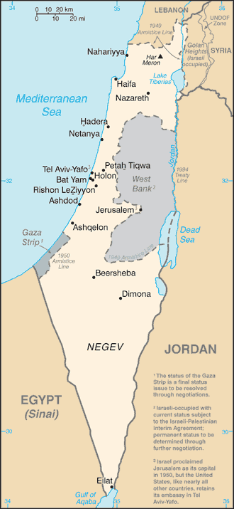 |
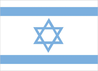
| The national flag of Israel | Borderline map of Israel |
| Flag description: white with a blue hexagram (six-pointed linear star) known as the Magen David (Star of David or Shield of David) centered between two equal horizontal blue bands near the top and bottom edges of the flag; the basic design resembles a traditional Jewish prayer shawl (tallit), which is white with blue stripes; the hexagram as a Jewish symbol dates back to medieval times. | Border length: total: 1,068 km. Border countries (total: 6): Egypt 208 km, Gaza Strip 59 km, Jordan 307 km, Lebanon 81 km, Syria 83 km, West Bank 330 km. |
Did you know about Israel?
- Israel gained independence in 1948. Until 1979 there were no set borders, only cease-fire lines. The situation of the Palestine people remains unsettled.
- All Jews worldwide have the right to Israeli citizenship.
- Israel was founded in 1948 as a homeland for Jews from around the world, but it is also home to many Palestinian Muslims and Christians.
Facts of Israel (IL)
Name conventional long form: State of Israel, conventional short form: Israel, local long form: Medinat Yisra’el, local short form: Yisra’el, etymology: named after the ancient Kingdom of Israel; according to Biblical tradition, the Jewish patriarch Jacob received the name “Israel” (“He who struggles with God”) after he wrestled an entire night with an angel of the Lord; Jacob’s 12 sons became the ancestors of the Israelites, also known as the Twelve Tribes of Israel, who formed the Kingdom of Israel
Codes: ISO; IL, Internet; .il
Capital city: Jerusalem
Language(s): Hebrew (official language), Arabic (used official languagely for Arab minority), English (most commonly used foreign language)
National holiday(s): Independence Day, 14 May (1948)
Motto: N/A
Currency: Israeli new shekel (ILS), since 1980
GPS: 31 30 N, 34 45 E, Jerusalem; 31 46 N 35 14 E
Location: Middle East, bordering the Mediterranean Sea, between Egypt and Lebanon
Geography note: Lake Tiberias (Sea of Galilee) is an important freshwater source; the Dead Sea is the second saltiest body of water in the world (after Lake Assal in Djibouti); in 2014, there were 423 settlements in the Israeli-occupied territories – 42 settlements in the Golan Heights, 381 sites in the occupied Palestinian territories to include 212 settlements and 134 outposts in the West Bank, and 35 settlements in East Jerusalem; there are no Israeli settlements in the Gaza Strip because all were evacuated in 2005 (2014 estimate)
Land boundaries: Egypt 208 km, Gaza Strip 59 km, Jordan 307 km, Lebanon 81 km, Syria 83 km, West Bank 330 km, total: 1,068 km
Maritime boundaries: Dead Sea, Gulf of Aqaba, Mediterranean Sea
Coastline: 273 km
Area: total: 20,770 sq km; land: 20,330 sq km, water: 440 sq km (total 8 522,04 mi2), slightly larger than New Jersey.
Roadways: total: 18,566 km, paved: 18,566 km (includes 449 km of expressways) (2011)
Waterways: N/A
Local time (capital): UTC+2, 7 hours ahead of Washington DC during Standard Time
Note to the local time: Daylight saving time: +1hr time difference: UTC+2 (7 hours ahead of Washington DC)
Population in Israel: 8 452 841
Population in Jerusalem: 695 500 (including the metropolitan areas)
Urbanization: urban population: 92.1% of total population (2015)
Major urban areas population: Tel Aviv-Yafo 3.608 million; Haifa 1.097 million; JERUSALEM (proclaimed capital) 839,000 (2015)
Population growth rate: 1.53% (2016 estimate)
Birth rate: 18.3 births / 1,000 population (2016 estimate)
Death rate: 5.2 deaths / 1,000 population (2016 estimate)
Age structure: 0-14 years: 27.73% (male 1,159,980 / female 1,106,946) 15-24 years: 15.52% (male 648,199 / female 620,218) 25-54 years: 37.15% (male 1,552,754 / female 1,484,059) 55-64 years: 8.51% (male 340,601 / female 355,382) 65 years and over: 11.09% (male 405,511 / female 500,877) (2016 estimate)
Median age: total: 29.7 years; male: 29.1 years, female: 30.4 years (2016 estimate)
Ethnic groups: Jewish 74.8% (of which Israel-born 75.6%, Europe/America/Oceania-born 16.6%, Africa-born 4.9%, Asia-born 2.9%), non-Jewish 25.2% (mostly Arab) (2015 estimate)
Religions: Jewish 74.8%, Muslim 17.6%, Christian 2%, Druze 1.6%, other 4% (2015 estimate)
Government type: Unitary parliamentary republic
Legal system: mixed legal system of English common law, British Mandate regulations, and Jewish, Christian, and Muslim religious laws
National anthem: Hatikva (The Hope)
Known national hazards: sandstorms may occur during spring and summer; droughts; periodic earthquakes
Major infectious diseases: N/A
Land use: agricultural land: 23.8%; arable land 13.7%; permanent crops 3.8%; permanent pasture 6.3%; forest: 7.1%; other: 69.1% (2011 estimate)
Agricultural products: citrus, vegetables, cotton; beef, poultry, dairy products
Industries: high-technology products (including aviation, communications, computer-aided design and manufactures, medical electronics, fiber optics), wood and paper products, potash and phosphates, food, beverages, and tobacco, caustic soda, cement, construction, met
Export commodities: machinery and equipment, software, cut diamonds, agricultural products, chemicals, textiles and apparel
Main export partners: US 27.5%, Hong Kong 8%, UK 6.1%, China 4.9% (2015)
Import commodities: raw materials, military equipment, investment goods, rough diamonds, fuels, grain, consumer goods
Main import partners: US 13%, China 9.3%, Switzerland 7.1%, Germany 6.1%, Belgium 5.3%, Italy 4% (2015)
Navigate the countries in Middle East faster and easier while driving, use the interactive Google maps for your driving directions. The continuously updated database contains over 220 countries and territories digitally mapped, hundreds of millions of businesses and places around the world positioned on the map.
Get fresh GPS navigation, traffic, and transit information – no matter what part of Israel, Jerusalem, any other city and country in Asia, or the world you’re in.
Do you like this Israel information page? Please don’t forget to share it with others! Thank you.