Mexico Google maps and Driving Directions
Get free driving directions, Google maps, traffic information for Mexico, and Mexico City (GPS: 19 26 N 99 08 W), the capital city of the country located in (the) North America, bordering the Caribbean Sea and the Gulf of Mexico, between Belize and the United States and bordering the North Pacific Ocean, between Guatemala and the United States.
Find any address in Mexico City on the Google map of Mexico (MX) with ease or calculate your up to date itinerary to and from Mexico or its neighboring counties like Belize, Guatemala, United States.
Sightseeing and exploring in America starts here, thanks to Google because its Earth Engine combines a multi-petabyte catalog of updated satellite imagery and geospatial datasets with planetary-scale analysis capabilities. Wonder the world, use the satellite map function of the Google maps to explore or see differences on the Earth’s surface, inland, or the surrounding areas of Mexico.
Google Maps Mexico
Mexico stretches from the US border southward into the ancient Aztec and Mayan heartlands. Independence from Spain came in 1836. One in five Mexicans lives in the sprawling capital.
Mexico is high, rugged mountains; low coastal plains; high plateaus; desert.
The map above fully covers Mexico with its road routes from cities to towns, road intersections in any region, provinces, prefectures, also with free driving directions in Mexico City or to the neighboring towns and countries. To look at the detailed map about a particular quarter in Mexico City, please click on the area and zoom to the place you are interested in the Google maps of Mexico (MX).
Be creative, use the extras of this Google map; This is a detailed, clear, zoomable, large road map of Mexico with its administrative divisions; 31 states (estados, singular – estado) and 1 city* (ciudad); Aguascalientes, Baja California, Baja California Sur, Campeche, Chiapas, Chihuahua, Coahuila de Zaragoza, Colima, Cuidad de Mexico*, Durango, Guanajuato, Guerrero, Hidalgo, Jalisco, Mexico, Michoacan de Ocampo, Morelos, Nayarit, Nuevo Leon, Oaxaca, Puebla, Queretaro, Quintana Roo, San Luis Potosi, Sinaloa, Sonora, Tabasco, Tamaulipas, Tlaxcala, Veracruz de Ignacio de la Llave (Veracruz), Yucatan, Zacatecas.
The interactive map above is also may be used as the satellite map of Mexico, or as a reverse search map for finding an address from its GPS coordinates.
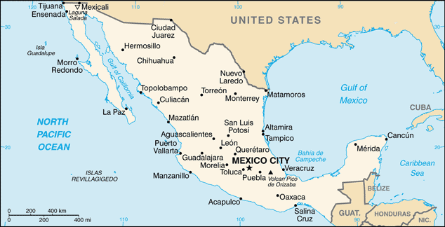
Mexico is bordered by the United States to the north and Belize and Guatemala to the southeast. Mexico is about one-fifth the size of the United States. Baja California in the west is an 800-mile (1,287-km) peninsula that forms the Gulf of California. In the east are the Gulf of Mexico and the Bay of Campeche, which is formed by Mexico’s other peninsula, the Yucatán. The center of Mexico is a great, high plateau, open to the north, with mountain chains on the east and west and with ocean-front lowlands beyond.
Mexico (area: 1 964 380 sq km / 758 451,05 sq mi), where the official language is Spanish, lying in America and using the currency; Mexican peso (MXN), set their clock to UTC-6. That means they are 1 hour behind Washington DC during Standard Time in Mexico City, the capital. Note to the time difference: Daylight saving time: +1hr begins first Sunday in April; ends last Sunday in October. Note: Mexico has four time zones.
The climate in Mexico; The plateau and high mountains are warm for much of the year. Pacific coast is tropical: storms occur mostly MarchDecember. Northwest is dry.
Geography in a nutshell; Coastal plains along the Pacific and Atlantic seaboards rise to a high arid central plateau. To the east and west are the Sierra Madre mountain ranges. Limestone lowlands form the projecting Yucatan peninsula.
Click here for more detailed information about Mexico.
Driving directions Mexico
The Google maps and Google Satellite maps of Mexico above showing the country, located next to Belize, Guatemala, United States. For your further reference, the latitude and longitude coordinates of Mexico are 23 00 N, 102 00 W , while the capital, Mexico City found at 19 26 N 99 08 W.
When you are traveling around Mexico, Mexico City, or its other cities, use this routing tool, providing up to date route planning service free of charge.
Look no further; get accurate driving directions in Mexico, North America, by filling the route planner form below.
Since Google acquired and introduced its digitalized maps in 2004, you’re probably familiar with its base functions, like finding an address or driving directions to locations. Still, Google maps also accommodate bicyclists, pedestrians, and also public transportation with special directions and customizable routes.
About Mexico and the capital, Mexico City
 |
 |
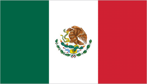
| The national flag of Mexico | Borderline map of Mexico |
| Flag description: three equal vertical bands of green (hoist side), white, and red; Mexico’s coat of arms (an eagle with a snake in its beak perched on a cactus) is centered in the white band; green signifies hope, joy, and love; white represents peace and honesty; red stands for hardiness, bravery, strength, and valor; the coat of arms is derived from a legend that the wandering Aztec people were to settle at a location where they would see an eagle on a cactus eating a snake; the city they founded, Tenochtitlan, is now Mexico City. Note: similar to the flag of Italy, which is shorter, uses lighter shades of red and green, and does not display anything in its white band. | Border length: total: 4,389 km. Border countries (total: 3): Belize 276 km, Guatemala 958 km, US 3,155 km. |
Did you know about Mexico?
- Mexico was conquered by Spain in the 16th century, but broke away in 1821 to form a Central American state. It became a republic in 1822.
- More people cross the USMexican border each year illegally or legally than any other border in the world.
- With more than 107 million people, Mexico is the largest Spanish-speaking country in the world and was once the center of the mighty Aztec Empire.
Facts of Mexico (MX)
Name conventional long form: United Mexican States, conventional short form: Mexico, local long form: Estados Unidos Mexicanos, local short form: Mexico, etymology: named after the Mexica, the largest and most powerful branch of the Aztecs; the meaning of the name is uncertain
Codes: ISO; MX, Internet; .mx
Capital city: Mexico City
Language(s): Spanish only 92.7%, Spanish and indigenous languages 5.7%, indigenous only 0.8%, unspecified 0.8%. Note: indigenous languages include various Mayan, Nahuatl, and other regional languages (2005)
National holiday(s): Independence Day, 16 September (1810)
Motto: N/A
Currency: Mexican peso (MXN)
GPS: 23 00 N, 102 00 W, Mexico City; 19 26 N 99 08 W
Location: North America, bordering the Caribbean Sea and the Gulf of Mexico, between Belize and the United States and bordering the North Pacific Ocean, between Guatemala and the United States
Geography note: strategic location on southern border of US; corn (maize), one of the world’s major grain crops, is thought to have originated in Mexico
Land boundaries: Belize 276 km, Guatemala 958 km, US 3,155 km, total: 4,389 km
Maritime boundaries: Caribbean Sea, Gulf of Mexico, Pacific Ocean
Coastline: 9,330 km
Area: total: 1,964,375 sq km; land: 1,943,945 sq km, water: 20,430 sq km (total 758 451,05 mi2), slightly less than three times the size of Texas.
Roadways: total: 377,660 km, paved: 137,544 km (includes 7,176 km of expressways), unpaved: 240,116 km (2012)
Waterways: 2,900 km (navigable rivers and coastal canals mostly connected with ports on the country’s east coast) (2012)
Local time (capital): UTC-6, 1 hour behind Washington DC during Standard Time
Note to the local time: Daylight saving time: +1hr begins first Sunday in April; ends last Sunday in October. Note: Mexico has four time zones
Population in Mexico: 130 759 074
Population in Mexico City: 19 013 000 (including the metropolitan areas)
Urbanization: urban population: 79.2% of total population (2015)
Major urban areas population: MEXICO CITY (capital) 20.999 million; Guadalajara 4.843 million; Monterrey 4.513 million; Puebla 2.984 million; Toluca de Lerdo 2.164 million; Tijuana 1.987 million (2015)
Population growth rate: 1.15% (2016 estimate)
Birth rate: 18.5 births / 1,000 population (2016 estimate)
Death rate: 5.3 deaths / 1,000 population (2016 estimate)
Age structure: 0-14 years: 27.26% (male 17,167,636 / female 16,402,301) 15-24 years: 17.72% (male 11,049,818 / female 10,770,843) 25-54 years: 40.69% (male 24,174,900 / female 25,938,909) 55-64 years: 7.41% (male 4,187,644 / female 4,944,802) 65 years and over: 6.93% (male 3,827,870 / female 4,702,026) (2016 estimate)
Median age: total: 28 years; male: 26.9 years, female: 29.1 years (2016 estimate)
Ethnic groups: mestizo (Amerindian-Spanish) 62%, predominantly Amerindian 21%, Amerindian 7%, other 10% (mostly European). Note: Mexico does not collect census data on ethnicity (2012 estimate)
Religions: Roman Catholic 82.7%, Pentecostal 1.6%, Jehovah’s Witness 1.4%, other Evangelical Churches 5%, other 1.9%, none 4.7%, unspecified 2.7% (2010 estimate)
Government type: Federal presidential constitutional republic
Legal system: civil law system with US constitutional law influence; judicial review of legislative acts
National anthem: Himno Nacional Mexicano
Known national hazards: tsunamis along the Pacific coast, volcanoes and destructive earthquakes in the center and south, and hurricanes on the Pacific, Gulf of Mexico, and Caribbean coastsvolcanism: volcanic activity in the central-southern part of the country; the volcanoes in Baja California are mostly dormant; Colima (elev. 3,850 m), which erupted in 2010, is Mexico’s most active volcano and is responsible for causing periodic evacuations of nearby villagers; it has been deemed a Decade Volcano by the International Association of Volcanology and Chemistry of the Earth’s Interior, worthy of study due to its explosive history and proximity to human populations; Popocatepetl (elev. 5,426 m) poses a threat to Mexico City; other historically active volcanoes include Barcena, Ceboruco, El Chichon, Michoacan-Guanajuato, Pico de Orizaba, San Martin, Socorro, and Tacana
Major infectious diseases: The degree of risk(s): intermediatefood or waterborne diseases: bacterial diarrhea and hepatitis A vectorborne disease: dengue fever. Note: active local transmission of Zika virus by Aedes species mosquitoes has been identified in this country (as of August 2016); it poses an important risk (a large number of cases possible) among US citizens if bitten by an infective mosquito; other less common ways to get Zika are through sex, via blood transfusion, or during pregnancy, in which the pregnant woman passes Zika virus to her fetus (2016)
Land use: agricultural land: 54.9%; arable land 11.8%; permanent crops 1.4%; permanent pasture 41.7%; forest: 33.3%; other: 11.8% (2011 estimate)
Agricultural products: corn, wheat, soybeans, rice, beans, cotton, coffee, fruit, tomatoes; beef, poultry, dairy products; wood products
Industries: food and beverages, tobacco, chemicals, iron and steel, petroleum, mining, textiles, clothing, motor vehicles, consumer durables, tourism
Export commodities: manufactured goods, oil and oil products, silver, fruits, vegetables, coffee, cotton
Main export partners: US 81.1% (2015)
Import commodities: metalworking machines, steel mill products, agricultural machinery, electrical equipment, automobile parts for assembly and repair, aircraft, aircraft parts
Main import partners: US 47.3%, China 17.7%, Japan 4.4% (2015)
Navigate the countries in North America faster and easier while driving, use the interactive Google maps for your driving directions. The continuously updated database contains over 220 countries and territories digitally mapped, hundreds of millions of businesses and places around the world positioned on the map.
Get fresh GPS navigation, traffic, and transit information – no matter what part of Mexico, Mexico City, any other city and country in America, or the world you’re in.
Do you like this Mexico information page? Please don’t forget to share it with others! Thank you.