France Google maps and Driving Directions
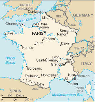
Get free driving directions, Google maps, traffic information for France, and Paris (GPS: 48 52 N 2 20 E), the capital city of the country located in Western Europe, bordering the Bay of Biscay and English Channel, between Belgium and Spain, southeast of the UK; bordering the Mediterranean Sea, between Italy and Spain.
Location of the overseas territories:
French Guiana: Northern South America, bordering the North Atlantic Ocean, between Brazil and Suriname.
Guadeloupe: the Caribbean, islands between the Caribbean Sea and the North Atlantic Ocean, southeast of Puerto Rico.
Martinique: the Caribbean, island between the Caribbean Sea and North Atlantic Ocean, north of Trinidad and Tobago.
Mayotte: Southern Indian Ocean, island in the Mozambique Channel, about halfway between northern Madagascar and northern Mozambique.
Reunion: Southern Africa, island in the Indian Ocean, east of Madagascar.
Find any address in Paris on the Google map of France (FR) with ease or calculate your up to date itinerary to and from France or its neighboring counties like Andorra, Belgium, Germany, Italy, Luxembourg, Monaco, Spain, Switzerland.
Sightseeing and exploring in Europe starts here, thanks to Google because its Earth Engine combines a multi-petabyte catalog of updated satellite imagery and geospatial datasets with planetary-scale analysis capabilities. Wonder the world, use the satellite map function of the Google maps to explore or see differences on the Earth’s surface, inland, or the surrounding areas of France.
Google Maps France
Stretching across western Europe, from the English Channel (la Manche) to the Mediterranean Sea, France was Europes first modern republic and is still a leading industrial power.
Metropolitan France is mostly flat plains or gently rolling hills in north and west; remainder is mountainous, especially Pyrenees in south, Alps in east french.
Guiana: low-lying coastal plains rising to hills and small mountains.
Guadeloupe: Basse-Terre is volcanic in origin with interior mountains; Grande-Terre is low limestone formation; most of the seven other islands are volcanic in origin.
Martinique: mountainous with indented coastline; dormant volcano.
Mayotte: generally undulating, with deep ravines and ancient volcanic peaks.
Reunion: mostly rugged and mountainous; fertile lowlands along coast.
The map above fully covers France with its road routes from cities to towns, road intersections in any region, provinces, prefectures, also with free driving directions in Paris or to the neighboring towns and countries. To look at the detailed map about a particular quarter in Paris, please click on the area and zoom to the place you are interested in the Google maps of France (FR).
Be creative, use the extras of this Google map; This is a detailed, clear, zoomable, large road map of France with its administrative divisions; 18 regions (regions, singular – region); Auvergne-Rhone-Alpes, Bourgogne-Franche-Comte (Burgundy-Free County), Bretagne (Brittany), Centre-Val de Loire (Center-Loire Valley), Corse (Corsica), Grand Est (Grand East), Guadeloupe, Guyane (French Guiana), Hauts-de-France (Upper France), Ile-de-France, Martinique, Mayotte, Normandie (Normandy), Nouvelle-Aquitaine (New Aquitaine), Occitanie (Occitania), Pays de la Loire (Lands of the Loire), Provence-Alpes-Cote d’Azur, Reunion. Note: France is divided into 13 metropolitan regions (including the “territorial collectivity” of Corse or Corsica) and 5 overseas regions (French Guiana, Guadeloupe, Martinique, Mayotte, and Reunion) and is subdivided into 96 metropolitan departments and 5 overseas departments (which are the same as the overseas regions).
The interactive map above is also may be used as the satellite map of France, or as a reverse search map for finding an address from its GPS coordinates.
France is about 80% the size of Texas. In the Alps near the Italian and Swiss borders is western Europe’s highest pointMont Blanc (15,781 ft 4,810 m). The forest-covered Vosges Mountains are in the northeast, and the Pyrénées are along the Spanish border. Except for extreme northern France, the country may be described as four river basins and a plateau. Three of the streams flow westthe Seine into the English Channel, the Loire into the Atlantic, and the Garonne into the Bay of Biscay. The Rhône flows south into the Mediterranean. For about 100 mi (161 km), the Rhine is France’s eastern border. In the Mediterranean, about 115 mi (185 km) east-southeast of Nice, is the island of Corsica (3,367 sq mi 8,721 sq km).
France (area: 640 597 sq km / 247 335,78 sq mi), where the official language is French, lying in Europe and using the currency; Euro (EUR), since 1999, set their clock to UTC+1. That means they are 6 hours ahead of Washington DC during Standard Time in Paris, the capital. Note to the time difference: Daylight saving time: +1hr begins last Sunday in March; ends last Sunday in October. Note: applies to metropolitan France only not to its overseas departments collectivies.
The climate in France; Three main climates: temperate and damp northwest; continental east; and Mediterranean south.
Geography in a nutshell; Broad plain covers the northern half of the country. Tall mountain ranges in the east and southwest, with a mountainous plateau in the center.
Click here for more detailed information about France.
Driving directions France
The Google maps and Google Satellite maps of France above showing the country, located next to Andorra, Belgium, Germany, Italy, Luxembourg, Monaco, Spain, Switzerland. For your further reference, the latitude and longitude coordinates of France are 46 00 N, 2 00 E , while the capital, Paris found at 48 52 N 2 20 E.
When you are traveling around France, Paris, or its other cities, use this routing tool, providing up to date route planning service free of charge.
Look no further; get accurate driving directions in France, Europe, by filling the route planner form below.
Since Google acquired and introduced its digitalized maps in 2004, you’re probably familiar with its base functions, like finding an address or driving directions to locations. Still, Google maps also accommodate bicyclists, pedestrians, and also public transportation with special directions and customizable routes.
About France and the capital, Paris
 |
 |
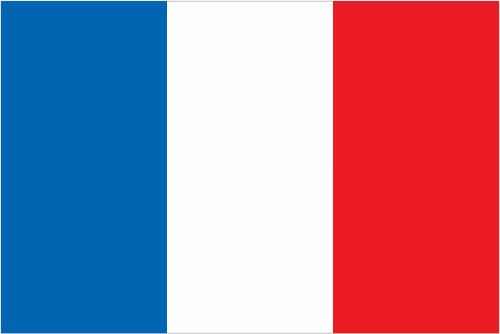
| The national flag of France | Borderline map of France |
| Flag description: three equal vertical bands of blue (hoist side), white, and red; known as the “Le drapeau tricolore” (French Tricolor), the origin of the flag dates to 1790 and the French Revolution when the “ancient French color” of white was combined with the blue and red colors of the Parisian militia; the official flag for all French dependent areas. Note: the design and or colors are similar to several other flags, including those of Belgium, Chad, Cote d’Ivoire, Ireland, Italy, Luxembourg, and the Netherlands. | Border length: metropolitan France – total: 2,751 km. Border countries (total: 8): Andorra 55 km, Belgium 556 km, Germany 418 km, Italy 476 km, Luxembourg 69 km, Monaco 6 km, Spain 646 km, Switzerland 525 km. French Guiana – total: 1,205 km. Border countries (total: 2): Brazil 649 km, Suriname 556 km. |
About Paris
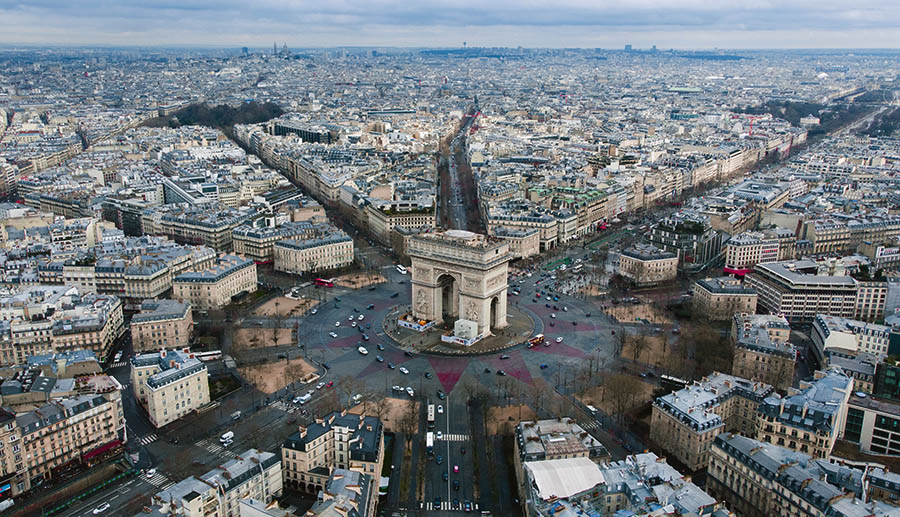
The City of Light always lives up to its reputation as one of the world’s most romantic cities. Ernest Hemingway referred to the splendors of Paris as a “moveable feast” and wrote, “There is never any ending to Paris, and the memory of each person who has lived in it differs from that of any other.” Here you can stroll along the Seine and the broad tree-lined boulevards; browse the chic shops and relax over coffee or wine at a cafe; visit the museums, monuments, and cathedrals; or sample the cuisine.
Did you know about France?
- France was a monarchy until the the Revolution of 1789. A republic created in 1792, following the abolition of the monarchy.
- France is the most popular tourist destination in the world, with over 80 million visitors a year.
- The largest country in western Europe, France is famed for its fine foods and wines, an inspiring fashion industry, its historic chateaux or grand houses, and some of the most stunning countryside.
France, including the island of Corsica, is the largest country in western Europe and a prominent member of the European Union. It is situated in the northwest of the European mainland and has coastlines on the English Channel, the Atlantic Ocean, and the Mediterranean Sea. Its principal topographical features are the mountain ranges of the Massif Central and the higher Alps, Jura and Pyrenees, an upland plateau in the southeast and a large area of rolling plains in the north. Mont Blanc on the France-Italy border is the highest point in the Alps at 4,807 meters or 15,770 feet. The principal rivers of France are the Seine, Rhone, Loire, and Garonne along with their many tributaries. Many of these are navigable and are used commercially for the transport of freight.
France was once a largely agricultural country and is famous for its fine wines, champagne, and brandy, but it has become increasingly industrialized and is now a leading manufacturer of a wide range of goods that are produced both for the home market and for export. It has valuable mineral reserves, including iron ore, petroleum, coal, natural gas, salt, zinc, potash, uranium, and lead. A significant proportion of the country is wooded, particularly the marginal areas, which are less suitable for farming, and forestry is an important factor in the economy. Fishing is carried out from many of the towns and villages along the country’s extensive coastline.
Paris
France’s beautiful capital city located on the River Seine. It built on both banks of the river and the two islands in the middle – the lie St Louis and the lie de la Cité. There has been a settlement at the site for at least 2,000 years, and the city itself has been famous for centuries. It has long been a magnet for artists, musicians, and writers and was particularly famous for its opera, ballet and street cafés and for being at the center of the Impressionist movement.
Modern Paris remains one of the most popular cities in the world and visitors come to experience its culture, high fashion, elegant shops, and nightlife and to view its many famous historical sights, including the Eiffel Tower, the Arc de Triomphe and the Cathedral of Notre Dame. Notre Dame (Our Lady) is one of the greatest and most beautiful Gothic cathedrals in Europe. It stands on the lie de la Cité, the island in the middle of the River Seine where Paris began. Construction started in 1163, with Pope Alexander III laying the first stone, and continued for 182 years until it completed in 1345. Inside, the end walls of the transepts are nearly two-thirds glass, including two beautiful rose windows, allowing light to fill the cathedral. Its famous gargoyles added in the 19th century during extensive renovations. Ravaged by pollution and the weather, restoration is ongoing to this day. South of Paris is the huge Palace of Versailles, which was built by King Louis IV in the 17th century. A more recent attraction is the Euro-Disney theme park located outside the city.
Facts of France (FR)
Name conventional long form: French Republic, conventional short form: France, local long form: Republique francaise, local short form: France, etymology: name derives from the Latin “Francia” meaning “Land of the Franks”; the Franks were a group of Germanic tribes located along the middle and lower Rhine River in the 3rd century A.D. who merged with Gallic-Roman populations in succeeding centuries and to whom they passed on their name
Codes: ISO; FR, Internet; .fr
Capital city: Paris
Language(s): French (official language) 100%, rapidly declining regional dialects and languages (Provencal, Breton, Alsatian, Corsican, Catalan, Basque, Flemish)overseas departments: French, Creole patois, Mahorian (a Swahili dialect)
National holiday(s): Fete de la Federation, 14 July (1790) abolishment of a constitutional monarchy; other names for the holiday are Fete Nationale (National Holiday) and quatorze juillet (14th of July)
Motto: Liberté, Égalité, Fraternité (Liberty, Equality, Fraternity)
Currency: Euro (EUR), since 1999
GPS: 46 00 N, 2 00 E, Paris; 48 52 N 2 20 E
Location: metropolitan France: Western Europe, bordering the Bay of Biscay and English Channel, between Belgium and Spain, southeast of the UK; bordering the Mediterranean Sea, between Italy and SpainFrench Guiana: Northern South America, bordering the North Atlantic Ocean, between Brazil and SurinameGuadeloupe: Caribbean, islands between the Caribbean Sea and the North Atlantic Ocean, southeast of Puerto RicoMartinique: Caribbean, island between the Caribbean Sea and North Atlantic Ocean, north of Trinidad and TobagoMayotte: Southern Indian Ocean, island in the Mozambique Channel, about halfway between northern Madagascar and northern MozambiqueReunion: Southern Africa, island in the Indian Ocean, east of Madagascar
Geography note: largest West European nation; most major French rivers – the Meuse, Seine, Loire, Charente, Dordogne, and Garonne – flow northward or westward into the Atlantic Ocean, only the Rhone flows southward into the Mediterranean Sea
Land boundaries: Andorra 55 km, Belgium 556 km, Germany 418 km, Italy 476 km, Luxembourg 69 km, Monaco 6 km, Spain 646 km, Switzerland 525 km. French Guiana; total: 1,205 km. Border countries total; 2; Brazil 649 km, Suriname 556 km, total: 2,751 km (metropolitan France)
Maritime boundaries: N/A
Coastline: total: 4,853 kmmetropolitan France: 3,427 km
Area: total: 643,801 sq km; land: 640,427 sq km; 549,970 sq km, water: 3,374 sq km (total 247 335,78 mi2), slightly more than four times the size of Georgia; slightly less than the size of Texas.
Roadways: total: 1,028,446 km (metropolitan France)paved: 1,028,446 km (includes 11,416 km of expressways). Note: not included are 5,100 km of roadways in overseas departments (2010)
Waterways: metropolitan France: 8,501 km (1,621 km navigable by craft up to 3,000 metric tons) (2010)
Local time (capital): UTC+1, 6 hours ahead of Washington DC during Standard Time
Note to the local time: Daylight saving time: +1hr begins last Sunday in March; ends last Sunday in October. Note: applies to metropolitan France only not to its overseas departments collectivies
Population in France: 65 233 271
Population in Paris: 9 854 000 (including the metropolitan areas)
Urbanization: urban population: 79.5% of total population (2015)
Major urban areas population: PARIS (capital) 10.843 million; Lyon 1.609 million; Marseille-Aix-en-Provence 1.605 million; Lille 1.027 million; Nice-Cannes 967,000; Toulouse 938,000 (2015)
Population growth rate: 0.41% (2016 estimate)
Birth rate: 12.3 births / 1,000 population (2016 estimate)
Death rate: 9.3 deaths / 1,000 population (2016 estimate)
Age structure: 0-14 years: 18.59% (male 6,354,241 / female 6,070,971) 15-24 years: 11.8% (male 4,035,407 / female 3,853,153) 25-54 years: 38.04% (male 12,799,923 / female 12,625,781) 55-64 years: 12.44% (male 4,011,853 / female 4,303,261) 65 years and over: 19.12% (male 5,510,337 / female 7,271,227) (2016 estimate)
Median age: total: 41.2 years; male: 39.5 years, female: 42.9 years (2016 estimate)
Ethnic groups: Celtic and Latin with Teutonic, Slavic, North African, Indochinese, Basque minorities overseas departments: black, white, mulatto, East Indian, Chinese, Amerindian
Religions: Christian (overwhelmingly Roman Catholic) 63-66%, Muslim 7-9%, Buddhist 0.5-0.75%, Jewish 0.5-0.75%, other 0.5-1.0%, none 23-28%note: France maintains a tradition of secularism and has not officially collected data on religious affiliation since the 1872 national census, which complicates assessments of France’s religious composition; an 1872 law prohibiting state authorities from collecting data on individuals’ ethnicity or religious beliefs was reaffirmed by a 1978 law emphasizing the prohibition of the collection or exploitation of personal data revealing an individual’s race, ethnicity, or political, philosophical, or religious opinions; a 1905 law codified France’s separation of church and state (2015 estimate)
Government type: Unitary semi-presidential republic
Legal system: civil law; review of administrative but not legislative acts
National anthem: La Marseillaise
Known national hazards: metropolitan France: flooding; avalanches; midwinter windstorms; drought; forest fires in south near the Mediterranean overseas departments: hurricanes (cyclones); flooding; volcanic activity (Guadeloupe, Martinique, Reunion)
Major infectious diseases: N/A
Land use: agricultural land: 52.7%; arable land 33.4%; permanent crops 1.8%; permanent pasture 17.5%; forest: 29.2%; other: 18.1% (2011 estimate)
Agricultural products: wheat, cereals, sugar beets, potatoes, wine grapes; beef, dairy products; fish
Industries: machinery, chemicals, automobiles, metallurgy, aircraft, electronics; textiles, food processing; tourism
Export commodities: machinery and transportation equipment, aircraft, plastics, chemicals, pharmaceutical products, iron and steel, beverages
Main export partners: Germany 15.9%, Spain 7.3%, US 7.2%, Italy 7.1%, UK 7.1%, Belgium 6.8% (2015)
Import commodities: machinery and equipment, vehicles, crude oil, aircraft, plastics, chemicals
Main import partners: Germany 19.5%, Belgium 10.7%, Italy 7.7%, Netherlands 7.5%, Spain 6.8%, US 5.5%, China 5.4%, UK 4.3% (2015)
Navigate the countries in Europe faster and easier while driving, use the interactive Google maps for your driving directions. The continuously updated database contains over 220 countries and territories digitally mapped, hundreds of millions of businesses and places around the world positioned on the map.
Get fresh GPS navigation, traffic, and transit information – no matter what part of France, Paris, any other city and country in Europe, or the world you’re in.
Do you like this France information page? Please don’t forget to share it with others! Thank you.