Mali Google maps and Driving Directions
Get free driving directions, Google maps, traffic information for Mali, and Bamako (GPS: 12 39 N 8 00 W), the capital city of the country located in (the) interior Western Africa, southwest of Algeria, north of Guinea, Cote d’Ivoire, and Burkina Faso, west of Niger.
Find any address in Bamako on the Google map of Mali (ML) with ease or calculate your up to date itinerary to and from Mali or its neighboring counties like Algeria, Burkina Faso, Guinea, Ivory Coast, Mauritania, Niger, Senegal.
Sightseeing and exploring in Africa starts here, thanks to Google because its Earth Engine combines a multi-petabyte catalog of updated satellite imagery and geospatial datasets with planetary-scale analysis capabilities. Wonder the world, use the satellite map function of the Google maps to explore or see differences on the Earth’s surface, inland, or the surrounding areas of Mali.
Google Maps Mali
A former French colony, Mali is landlocked in the heart of west Africa. The 1991 coup ended the 23-year dictatorship of Moussa Traoré and ushered in multiparty elections from 1992.
Mali is mostly flat to rolling northern plains covered by sand; savanna in south, rugged hills in northeast.
The map above fully covers Mali with its road routes from cities to towns, road intersections in any region, provinces, prefectures, also with free driving directions in Bamako or to the neighboring towns and countries. To look at the detailed map about a particular quarter in Bamako, please click on the area and zoom to the place you are interested in the Google maps of Mali (ML).
Be creative, use the extras of this Google map; This is a detailed, clear, zoomable, large road map of Mali with its administrative divisions; 8 regions (regions, singular – region), 1 district*; District de Bamako*, Gao, Kayes, Kidal, Koulikoro, Mopti, Segou, Sikasso, Tombouctou (Timbuktu); note – two new regions, Menaka and Taoudenni, were reportedly created in early 2016, but these have not yet been vetted by the US Board on Geographic Names.
The interactive map above is also may be used as the satellite map of Mali, or as a reverse search map for finding an address from its GPS coordinates.
Most of Mali, in West Africa, lies in the Sahara. A landlocked country four-fifths the size of Alaska, it is bordered by Guinea, Senegal, Mauritania, Algeria, Niger, Burkina Faso, and the Côte d’Ivoire. The only fertile area is in the south, where the Niger and Senegal rivers provide water for irrigation.
Mali (area: 1 241 240 sq km / 479 245,25 sq mi), where the official language is French, lying in Africa and using the currency; West African CFA franc (XOF), set their clock to UTC 0. That means they are 5 hours ahead of Washington DC during Standard Time in Bamako, the capital. Note to the time difference: N/A.
The climate in Mali; In the south, intensely hot, dry weather precedes the westerly rains. The north is almost rainless.
Geography in a nutshell; The northern half of the country lies in the Sahara. The inland delta of the Niger River flows through a grassy savanna region in the south.
Click here for more detailed information about Mali.
Driving directions Mali
The Google maps and Google Satellite maps of Mali above showing the country, located next to Algeria, Burkina Faso, Guinea, Ivory Coast, Mauritania, Niger, Senegal. For your further reference, the latitude and longitude coordinates of Mali are 17 00 N, 4 00 W , while the capital, Bamako found at 12 39 N 8 00 W.
When you are traveling around Mali, Bamako, or its other cities, use this routing tool, providing up to date route planning service free of charge.
Look no further; get accurate driving directions in Mali, Africa, by filling the route planner form below.
Since Google acquired and introduced its digitalized maps in 2004, you’re probably familiar with its base functions, like finding an address or driving directions to locations. Still, Google maps also accommodate bicyclists, pedestrians, and also public transportation with special directions and customizable routes.
About Mali and the capital, Bamako
 |
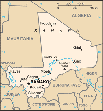 |
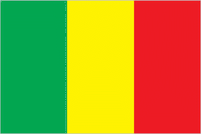
| The national flag of Mali | Borderline map of Mali |
| Flag description: three equal vertical bands of green (hoist side), yellow, and red. Note: uses the popular Pan-African colors of Ethiopia; the colors from left to right are the same as those of neighboring Senegal (which has an additional green central star) and the reverse of those on the flag of neighboring Guinea. | Border length: total: 7,908 km. Border countries (total: 7): Algeria 1,359 km, Burkina Faso 1,325 km, Cote d’Ivoire 599 km, Guinea 1,062 km, Mauritania 2,236 km, Niger 838 km, Senegal 489 km. |
Did you know about Mali?
- Mali achieved independence from France in confederation with Senegal on June 20, 1960, but split away later the same year to form a republic.
- Tombouctou (Timbuktu) was the center of the 14th-century Malinké trading empire.
- The Dogons of Mali build distinctive tall, thin houses high up on a cliff for defense purposes.
Facts of Mali (ML)
Name conventional long form: Republic of Mali, conventional short form: Mali, local long form: Republique de Mali, local short form: Mali, former: French Sudan and Sudanese RepubliC. Note: name derives from the West African Mali Empire of the 13th to 16th centuries A.D.
Codes: ISO; ML, Internet; .ml
Capital city: Bamako
Language(s): French (official language), Bambara 46.3%, Peul/Foulfoulbe 9.4%, Dogon 7.2%, Maraka/Soninke 6.4%, Malinke 5.6%, Sonrhai/Djerma 5.6%, Minianka 4.3%, Tamacheq 3.5%, Senoufo 2.6%, Bobo 2.1%, unspecified 0.7%, other 6.3%. Note: Mali has 13 national languages in addition to its official language language (2009 estimate)
National holiday(s): Independence Day, 22 September (1960)
Motto: Un peuple, un but, une foi (One people, one goal, one faith)
Currency: West African CFA franc (XOF)
GPS: 17 00 N, 4 00 W, Bamako; 12 39 N 8 00 W
Location: interior Western Africa, southwest of Algeria, north of Guinea, Cote d’Ivoire, and Burkina Faso, west of Niger
Geography note: landlocked country; divided into three natural zones: the southern, cultivated Sudanese; the central, semiarid Sahelian; and the northern, arid Saharan
Land boundaries: Algeria 1,359 km, Burkina Faso 1,325 km, Cote d’Ivoire 599 km, Guinea 1,062 km, Mauritania 2,236 km, Niger 838 km, Senegal 489 km, total: 7,908 km
Maritime boundaries: N/A
Coastline: 0 km (landlocked country)
Area: total: 1,240,192 sq km; land: 1,220,190 sq km, water: 20,002 sq km (total 479 245,25 mi2), slightly less than twice the size of Texas.
Roadways: total: 22,474 km, paved: 5,522 km, unpaved: 16,952 km (2009)
Waterways: 1,800 km (downstream of Koulikoro; low water levels on the River Niger cause problems in dry years; in the months before the rainy season the river is not navigable by commercial vessels) (2011)
Local time (capital): UTC 0, 5 hours ahead of Washington DC during Standard Time
Note to the local time: N/A
Population in Mali: 19 107 706
Population in Bamako: 1 323 200 (including the metropolitan areas)
Urbanization: urban population: 39.9% of total population (2015)
Major urban areas population: BAMAKO (capital) 2.515 million (2015)
Population growth rate: 2.96% (2016 estimate)
Birth rate: 44.4 births / 1,000 population (2016 estimate)
Death rate: 12.6 deaths / 1,000 population (2016 estimate)
Age structure: 0-14 years: 47.27% (male 4,145,290 / female 4,110,642) 15-24 years: 19.19% (male 1,601,474 / female 1,751,161) 25-54 years: 26.82% (male 2,173,415 / female 2,511,844) 55-64 years: 3.76% (male 327,923 / female 329,296) 65 years and over: 2.95% (male 257,519 / female 258,544) (2016 estimate)
Median age: total: 16.2 years; male: 15.5 years, female: 16.8 years (2016 estimate)
Ethnic groups: Bambara 34.1%, Fulani (Peul) 14.7%, Sarakole 10.8%, Senufo 10.5%, Dogon 8.9%, Malinke 8.7%, Bobo 2.9%, Songhai 1.6%, Tuareg 0.9%, other Malian 6.1%, from member of Economic Community of West African States 0.3%, other 0.4% (2012-13 estimate)
Religions: Muslim 94.8%, Christian 2.4%, Animist 2%, none 0.5%, unspecified 0.3% (2009 estimate)
Government type: Unitary semi-presidential republic
Legal system: civil law system based on the French civil law model and influenced by customary law; judicial review of legislative acts in Constitutional Court
National anthem: Pour l’Afrique et pour toi, Mali (For Africa and for you, Mali)
Known national hazards: hot, dust-laden harmattan haze common during dry seasons; recurring droughts; occasional Niger River flooding
Major infectious diseases: The degree of risk(s): very high food or waterborne diseases: bacterial and protozoal diarrhea, hepatitis A, and typhoid fever vectorborne diseases: malaria and dengue feverwater contact disease: schistosomiasisrespiratory disease: meningococcal meningitisanimal contact disease: rabies (2016)
Land use: agricultural land: 34.1%; arable land 5.6%; permanent crops 0.1%; permanent pasture 28.4%; forest: 10.2%; other: 55.7% (2011 estimate)
Agricultural products: cotton, millet, rice, corn, vegetables, peanuts; cattle, sheep, goats
Industries: food processing; construction; phosphate and gold mining
Export commodities: cotton, gold, livestock
Main export partners: Switzerland 48.5%, China 9.4%, India 9.1%, Bangladesh 8%, Thailand 4.5%, Indonesia 4.4% (2015)
Import commodities: petroleum, machinery and equipment, construction materials, foodstuffs, textiles
Main import partners: Cote dIvoire 9.9%, France 9.5%, Senegal 7.7%, China 7% (2015)
Navigate the countries in Africa faster and easier while driving, use the interactive Google maps for your driving directions. The continuously updated database contains over 220 countries and territories digitally mapped, hundreds of millions of businesses and places around the world positioned on the map.
Get fresh GPS navigation, traffic, and transit information – no matter what part of Mali, Bamako, any other city and country in Africa, or the world you’re in.
Do you like this Mali information page? Please don’t forget to share it with others! Thank you.