Guinea-Bissau Google maps and Driving Directions
Get free driving directions, Google maps, traffic information for Guinea–Bissau, and Bissau (GPS: 11 51 N 15 35 W), the capital city of the country located in (the) Western Africa, bordering the North Atlantic Ocean, between Guinea and Senegal.
Find any address in Bissau on the Google map of Guinea–Bissau (GW) with ease or calculate your up to date itinerary to and from Guinea–Bissau or its neighboring counties like Guinea, Senegal.
Sightseeing and exploring in Africa starts here, thanks to Google because its Earth Engine combines a multi-petabyte catalog of updated satellite imagery and geospatial datasets with planetary-scale analysis capabilities. Wonder the world, use the satellite map function of the Google maps to explore or see differences on the Earth’s surface, inland, or the surrounding areas of Guinea–Bissau.
Google Maps Guinea-Bissau
Known as Portuguese Guinea while a colony, Guinea–Bissau lies on Africas west coast. Since 1994, its nascent democracy has been plagued by coups and rebellions.
Guinea–Bissau is mostly low-lying coastal plain with a deeply indented estuarine coastline rising to savanna in east; numerous off-shore islands including the Arquipelago Dos Bijagos consisting of 18 main islands and many small islets.
The map above fully covers Guinea–Bissau with its road routes from cities to towns, road intersections in any region, provinces, prefectures, also with free driving directions in Bissau or to the neighboring towns and countries. To look at the detailed map about a particular quarter in Bissau, please click on the area and zoom to the place you are interested in the Google maps of Guinea–Bissau (GW).
Be creative, use the extras of this Google map; This is a detailed, clear, zoomable, large road map of Guinea–Bissau with its administrative divisions; 9 regions (regioes, singular – regiao); Bafata, Biombo, Bissau, Bolama/Bijagos, Cacheu, Gabu, Oio, Quinara, Tombali.
The interactive map above is also may be used as the satellite map of Guinea–Bissau, or as a reverse search map for finding an address from its GPS coordinates.
A neighbor of Senegal and Guinea in West Africa, on the Atlantic coast, Guinea–Bissau is about half the size of South Carolina. The country is a low-lying coastal region of swamps, rain forests, and mangrove-covered wetlands, with about 25 islands off the coast. The Bijagos archipelago extends 30 mi (48 km) out to sea.
Guinea–Bissau (area: 36 125 sq km / 13 947,93 sq mi), where the official language is Portuguese, lying in Africa and using the currency; West African CFA franc (XOF), set their clock to UTC 0. That means they are 5 hours ahead of Washington DC during Standard Time in Bissau, the capital. Note to the time difference: N/A.
The climate in Guinea–Bissau; Tropical, with wet season May-November and dry season December-April. Hot, dry harmattan desert wind blows during dry season.
Geography in a nutshell; Low-lying, apart from savanna highlands in northeast. Rainforests and swamps are found along coastal areas.
Click here for more detailed information about Guinea-Bissau.
Driving directions Guinea-Bissau
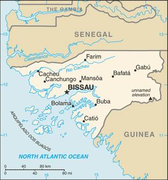
The Google maps and Google Satellite maps of Guinea–Bissau above showing the country, located next to Guinea, Senegal. For your further reference, the latitude and longitude coordinates of Guinea–Bissau are 12 00 N, 15 00 W , while the capital, Bissau found at 11 51 N 15 35 W.
When you are traveling around Guinea–Bissau, Bissau, or its other cities, use this routing tool, providing up to date route planning service free of charge.
Look no further; get accurate driving directions in Guinea–Bissau, Africa, by filling the route planner form below.
Since Google acquired and introduced its digitalized maps in 2004, you’re probably familiar with its base functions, like finding an address or driving directions to locations. Still, Google maps also accommodate bicyclists, pedestrians, and also public transportation with special directions and customizable routes.
About Guinea-Bissau and the capital, Bissau
 |
 |
| The national flag of Guinea–Bissau | Borderline map of Guinea–Bissau |
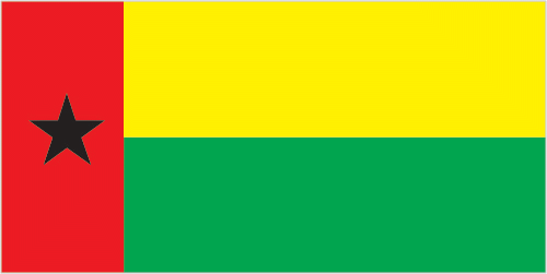
| Flag description: two equal horizontal bands of yellow (top) and green with a vertical red band on the hoist side; there is a black five-pointed star centered in the red band; yellow symbolizes the sun; green denotes hope; red represents bloodshed during the struggle for independence; the black star stands for African unity. Note: uses the popular Pan-African colors of Ethiopia; the flag design was heavily influenced by the Ghanaian flag. | Border length: total: 762 km. Border countries (total: 2): Guinea 421 km, Senegal 341 km. |
Did you know about Guinea-Bissau?
- Guinea–Bissau is so-called to distinguish it from the former French Guinea. Formerly a territory of Portugal, it achieved self-government in 1973.
- In 1974, Guinea–Bissau became the first Portuguese colony to gain independence.
- Cashews, groundnuts, coconuts, and rice are the main crops grown by Guinea–Bissaus farmers, while its main natural resources are fish and timber.
Facts of Guinea-Bissau (GW)
Name conventional long form: Republic of Guinea–Bissau, conventional short form: Guinea–Bissau, local long form: Republica da Guine-Bissau, local short form: Guine-Bissau, former: Portuguese Guinea. Note: the country named after the Guinea region of West Africa that lies along the Gulf of Guinea and stretches north to the Sahel; “Bissau” distinguishes the country from neighboring Guinea
Codes: ISO; GW, Internet; .gw
Capital city: Bissau
Language(s): Crioulo 90.4%, Portuguese 27.1% (official language), French 5.1%, English 2.9%, other 2.4%. Note: shares sum to more than 100% because some respondents gave more than one answer on the census (2008 estimate)
National holiday(s): Independence Day, 24 September (1973)
Motto: Unidade, Luta, Progresso (Unity, Fight, Progress)
Currency: West African CFA franc (XOF)
GPS: 12 00 N, 15 00 W, Bissau; 11 51 N 15 35 W
Location: Western Africa, bordering the North Atlantic Ocean, between Guinea and Senegal
Geography note: this small country is swampy along its western coast and low-lying inland
Land boundaries: Guinea 421 km, Senegal 341 km, total: 762 km
Maritime boundaries: N/A
Coastline: 350 km
Area: total: 36,125 sq km; land: 28,120 sq km, water: 8,005 sq km (total 13 947,93 mi2), slightly less than three times the size of Connecticut.
Roadways: total: 3,455 km, paved: 965 km, unpaved: 2,490 km (2002)
Waterways: (rivers are partially navigable; many inlets and creeks provide shallow-water access to much of interior) (2012)
Local time (capital): UTC 0, 5 hours ahead of Washington DC during Standard Time
Note to the local time: N/A
Population in Guinea–Bissau: 1 907 268
Population in Bissau: 296 900 (including the metropolitan areas)
Urbanization: urban population: 49.3% of total population (2015)
Major urban areas population: BISSAU (capital) 492,000 (2015)
Population growth rate: 1.88% (2016 estimate)
Birth rate: 32.9 births / 1,000 population (2016 estimate)
Death rate: 14.1 deaths / 1,000 population (2016 estimate)
Age structure: 0-14 years: 39.28% (male 344,976 / female 346,102) 15-24 years: 20.17% (male 176,050 / female 178,842) 25-54 years: 32.53% (male 285,258 / female 286,955) 55-64 years: 4.62% (male 31,030 / female 50,215) 65 years and over: 3.4% (male 22,121 / female 37,610) (2016 estimate)
Median age: total: 20 years; male: 19.5 years, female: 20.5 years (2016 estimate)
Ethnic groups: Fulani 28.5%, Balanta 22.5%, Mandinga 14.7%, Papel 9.1%, Manjaco 8.3%, Beafada 3.5%, Mancanha 3.1%, Bijago 2.1%, Felupe 1.7%, Mansoanca 1.4%, Balanta Mane 1%, other 1.8%, none 2.2% (2008 estimate)
Religions: Muslim 45.1%, Christian 22.1%, animist 14.9%, none 2%, unspecified 15.9% (2008 estimate)
Government type: Unitary semi-presidential republic
Legal system: mixed legal system of civil law which incorporated Portuguese law at independence and influenced by early French civil code and customary law
National anthem: Esta é a Nossa Pátria Bem Amada (This is Our Beloved Homeland)
Known national hazards: hot, dry, dusty harmattan haze may reduce visibility during dry season; brush fires
Major infectious diseases: The degree of risk(s): very high food or waterborne diseases: bacterial and protozoal diarrhea, hepatitis A, and typhoid fever vectorborne diseases: malaria, dengue fever, and yellow feverwater contact disease: schistosomiasis animal contact disease: rabies (2016)
Land use: agricultural land: 44.8%; arable land 8.2%; permanent crops 6.9%; permanent pasture 29.7%; forest: 55.2%; other: 0% (2011 estimate)
Agricultural products: rice, corn, beans, cassava (manioc, tapioca), cashew nuts, peanuts, palm kernels, cotton; timber; fish
Industries: agricultural products processing, beer, soft drinks
Export commodities: fish, shrimp; cashews, peanuts, palm kernels, raw and sawn lumber
Main export partners: India 63.5%, Nigeria 20.3%, China 5.7%, Togo 5.6% (2015)
Import commodities: foodstuffs, machinery and transport equipment, petroleum products
Main import partners: Portugal 27.1%, Senegal 12.8%, China 6.5%, Spain 5.5%, Cuba 4.8% (2015)
Navigate the countries in Africa faster and easier while driving, use the interactive Google maps for your driving directions. The continuously updated database contains over 220 countries and territories digitally mapped, hundreds of millions of businesses and places around the world positioned on the map.
Get fresh GPS navigation, traffic, and transit information – no matter what part of Guinea–Bissau, Bissau, any other city and country in Africa, or the world you’re in.
Do you like this Guinea–Bissau information page? Please don’t forget to share it with others! Thank you.