Iceland Google maps and Driving Directions
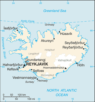
Get free driving directions, Google maps, traffic information for Iceland, and Reykjavík (GPS: 64 09 N 21 57 W), the capital city of the country located in (the) Northern Europe, island between the Greenland Sea and the North Atlantic Ocean, northwest of the United Kingdom.
Find any address in Reykjavík on the Google map of Iceland (IS) with ease or calculate your up to date itinerary to and from Iceland or its neighboring counties like N/A.
Sightseeing and exploring in Europe starts here, thanks to Google because its Earth Engine combines a multi-petabyte catalog of updated satellite imagery and geospatial datasets with planetary-scale analysis capabilities. Wonder the world, use the satellite map function of the Google maps to explore or see differences on the Earth’s surface, inland, or the surrounding areas of Iceland.
Google Maps Iceland
Europes westernmost country, Icelands strategic ocean location straddles the Mid-Atlantic Ridge. Its spectacular landscape is largely uninhabited, aside from coastal towns.
Iceland is mostly plateau interspersed with mountain peaks, icefields; coast deeply indented by bays and fiords.
The map above fully covers Iceland with its road routes from cities to towns, road intersections in any region, provinces, prefectures, also with free driving directions in Reykjavík or to the neighboring towns and countries. To look at the detailed map about a particular quarter in Reykjavik, please click on the area and zoom to the place you are interested in the Google maps of Iceland (IS).
Be creative, use the extras of this Google map; This is a detailed, clear, zoomable, large road map of Iceland with its administrative divisions; 8 regions; Austurland, Hofudhborgarsvaedhi, Nordhurland Eystra, Nordhurland Vestra, Sudhurland, Sudhurnes, Vestfirdhir, Vesturland.
The interactive map above is also may be used as the satellite map of Iceland, or as a reverse search map for finding an address from its GPS coordinates.
Iceland, an island about the size of Kentucky, lies in the north Atlantic Ocean east of Greenland and just touches the Arctic Circle. It is one of the most volcanic regions in the world. More than 13% is covered by snowfields and glaciers, and most of the people live in the 7% of the island that is made up of fertile coastland. The Gulf Stream keeps Iceland’s climate milder than one would expect from an island near the Arctic Circle.
Iceland (area: 103 000 sq km / 39 768,51 sq mi), where the official language is Icelandic, lying in Europe and using the currency; Icelandic króna (ISK), since 1918, set their clock to UTC 0. That means they are 5 hours ahead of Washington DC during Standard Time in Reykjavik, the capital. Note to the time difference: N/A.
The climate in Iceland; Its location in the middle of the Gulf Stream moderates the climate. Mild winters and brief, cool summers.
Geography in a nutshell; Grassy coastal lowlands, with fjords in the north. Central plateau of cold lava desert, geothermal springs, and glaciers. Around 200 volcanoes, with numerous geysers and solfataras.
Click here for more detailed information about Iceland.
Driving directions Iceland
The Google maps and Google Satellite maps of Iceland above showing the country, located next to N/A. For your further reference, the latitude and longitude coordinates of Iceland are 65 00 N, 18 00 W , while the capital, Reykjavik found at 64 09 N 21 57 W.
When you are traveling around Iceland, Reykjavik, or its other cities, use this routing tool, providing up to date route planning service free of charge.
Look no further; get accurate driving directions in Iceland, Europe, by filling the route planner form below.
Since Google acquired and introduced its digitalized maps in 2004, you’re probably familiar with its base functions, like finding an address or driving directions to locations. Still, Google maps also accommodate bicyclists, pedestrians, and also public transportation with special directions and customizable routes.
About Iceland and the capital, Reykjavík
 |
 |
| The national flag of Iceland | Borderline map of Iceland |
| Flag description: blue with a red cross outlined in white extending to the edges of the flag; the vertical part of the cross is shifted to the hoist side in the style of the Dannebrog (Danish flag); the colors represent three of the elements that make up the island: red is for the island’s volcanic fires, white recalls the snow and ice fields of the island, and blue is for the surrounding ocean. | Border length: 0 km. |
Did you know about Iceland?
- Ruled by the Danes from the 14th century, Iceland became a realm within the kingdom of Denmark in 1918, and a republic in 1944.
- The word geyser is taken from Geysir (the “gusher) in southwest Iceland.
- About one-tenth of volcanic Iceland is covered with glaciers. There are also many hot springs.
The island republic of Iceland located in the North Atlantic Ocean about 298 kilometers or 186 miles east of Greenland. It is composed of volcanic rock and lies in an active earthquake zone. It has a deeply indented coastline and numerous fjords and bays. The center of the island is a barren, uninhabited, high, rocky plateau composed of solidified lava from which rise volcanic mountains. A large, broad peninsula projects from the northwestern corner of the island. The inhabited lowlands of Iceland, comprising about a sixth of the total land area, occur in the coastal regions, especially in the southwest and southeast. Several small islands lie off Iceland’s coast. Iceland has numerous lakes, fast-flowing rivers, and waterfalls that are harnessed to generate the hydroelectric power that supplies the electricity needs of the island.
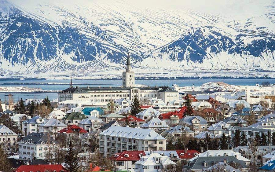
With its numerous volcanoes and extensive glaciers and snowfields, Iceland is truly a ‘land of ice and fire.’ Other signs of the volcanic activity lying just beneath the surface provided by numerous geysers, bubbling mud pools, hot springs, and heated geothermal pools. Hot springs are used to heat most of the homes and businesses in Reykjavik, the country’s capital.
Very little of the land in Iceland can cultivated, and the main crops are root vegetables such as turnips and potatoes. Fishing and fish processing are the mainstay of the Icelandic economy, with much of the catch exported. Iceland lacks exploitable minerals, apart from diatomite, and must import raw materials for its industries which do, however, benefit from the availability of cheap electricity. Aluminum and ferrosilicon, nitrates for fertilizers, cement, and chemicals produced for export. Other manufactured goods include paints, textiles, clothing, and footwear.
Tourism is of growing importance to the island. Visitors attracted by Iceland’s spectacular scenery and volcanic features, cultural and historical sites and opportunities for outdoor activities.
Facts of Iceland (IS)
Name conventional long form: Republic of Iceland, conventional short form: Iceland, local long form: Lydveldid Island, local short form: Island, etymology: Floki VILGERDARSON, an early explorer of the island (9th century), applied the name “land of ice” after spotting a fjord full of drift ice to the north and spending a bitter winter on the island; he eventually settled on the island, however, after he saw how it greened up in the summer and that it was in fact habitable
Codes: ISO; IS, Internet; .is
Capital city: Reykjavík
Language(s): Icelandic, English, Nordic languages, German widely spoken
National holiday(s): Independence Day, 17 June (1944)
Motto: N/A
Currency: Icelandic króna (ISK), since 1918
GPS: 65 00 N, 18 00 W, Reykjavík; 64 09 N 21 57 W
Location: Northern Europe, island between the Greenland Sea and the North Atlantic Ocean, northwest of the United Kingdom
Geography note: strategic location between Greenland and Europe; westernmost European country; Reykjavik is the northernmost national capital in the world; more land covered by glaciers than in all of continental Europe
Land boundaries: N/A, 0 km
Maritime boundaries: Atlantic Ocean, Norwegian Sea
Coastline: 4,970 km
Area: total: 103,000 sq km; land: 100,250 sq km, water: 2,750 sq km (total 39 768,51 mi2), slightly smaller than Pennsylvania; about the same size as Kentucky.
Roadways: total: 12,890 km, paved/oiled gravel: 4,782 km (excludes urban roads), unpaved: 8,108 km (2012)
Waterways: N/A
Local time (capital): UTC 0, 5 hours ahead of Washington DC during Standard Time
Note to the local time: N/A
Population in Iceland: 337 780
Population in Reykjavik: 184 200 (including the metropolitan areas)
Urbanization: urban population: 94.1% of total population (2015)
Major urban areas population: REYKJAVIK (capital) 184,000 (2014)
Population growth rate: 1.17% (2016 estimate)
Birth rate: 13.8 births / 1,000 population (2016 estimate)
Death rate: 6.3 deaths / 1,000 population (2016 estimate)
Age structure: 0-14 years: 20.4% (male 35,009 / female 33,495) 15-24 years: 13.77% (male 23,452 / female 22,789) 25-54 years: 39.99% (male 67,878 / female 66,428) 55-64 years: 11.75% (male 19,848 / female 19,622) 65 years and over: 14.1% (male 22,130 / female 25,227) (2016 estimate)
Median age: total: 36.3 years; male: 35.7 years, female: 36.9 years (2016 estimate)
Ethnic groups: homogeneous mixture of descendants of Norse and Celts 94%, population of foreign origin 6%
Religions: Evangelical Lutheran Church of Iceland (official) 73.8%, Roman Catholic 3.6%, Reykjavik Free Church 2.9%, Hafnarfjorour Free Church 2%, The Independent Congregation 1%, other religions 3.9% (includes Pentecostal and Asatru Association), none 5.6%, other or unspecified 7.2% (2015 estimate)
Government type: Unitary parliamentary republic
Legal system: civil law system influenced by the Danish model
National anthem: Lofsöngur (Hymn)
Known national hazards: earthquakes and volcanic activityvolcanism: Iceland, situated on top of a hotspot, experiences severe volcanic activity; Eyjafjallajokull (elev. 1,666 m) erupted in 2010, sending ash high into the atmosphere and seriously disrupting European air traffic; scientists continue to monitor nearby Katla (elev. 1,512 m), which has a high probability of eruption in the very near future, potentially disrupting air traffic; Grimsvoetn and Hekla are Iceland’s most active volcanoes; other historically active volcanoes include Askja, Bardarbunga, Brennisteinsfjoll, Esjufjoll, Hengill, Krafla, Krisuvik, Kverkfjoll, Oraefajokull, Reykjanes, Torfajokull, and Vestmannaeyjar
Major infectious diseases: N/A
Land use: agricultural land: 18.7%; arable land 1.2%; permanent crops 0%; permanent pasture 17.5%; forest: 0.3%; other: 81% (2011 estimate)
Agricultural products: potatoes, carrots, green vegetables; mutton, chicken, pork, beef, dairy products; fish
Industries: tourism, fish processing; aluminum smelting, ferrosilicon production; geothermal power, hydropower, tourism
Export commodities: fish and fish products 40%, aluminum, animal products, ferrosilicon, diatomite (2010 estimate)
Main export partners: Netherlands 26.1%, UK 11.6%, Spain 11.5%, Germany 7.4%, France 5.7%, US 5.7%, Norway 4.7% (2015)
Import commodities: machinery and equipment, petroleum products, foodstuffs, textiles
Main import partners: Norway 10.1%, Germany 8.6%, US 7.9%, China 7.9%, Denmark 7.1%, Netherlands 5.9%, Brazil 5.8%, UK 5% (2015)
Navigate the countries in Europe faster and easier while driving, use the interactive Google maps for your driving directions. The continuously updated database contains over 220 countries and territories digitally mapped, hundreds of millions of businesses and places around the world positioned on the map.
Get fresh GPS navigation, traffic, and transit information – no matter what part of Iceland, Reykjavík, any other city and country in Europe, or the world you’re in.
Do you like this Iceland information page? Please don’t forget to share it with others! Thank you.