Botswana Google maps and Driving Directions
Get free driving directions, Google maps, traffic information for Botswana, and Gaborone (GPS: 24 38 S 25 54 E), the capital city of the country located in (the) Southern Africa, north of South Africa.
Find any address in Gaborone on the Google map of Botswana (BW) with ease or calculate your up to date itinerary to and from Botswana or its neighboring counties like Namibia, South Africa, Zambia, Zimbabwe.
Sightseeing and exploring in Africa starts here, thanks to Google because its Earth Engine combines a multi-petabyte catalog of updated satellite imagery and geospatial datasets with planetary-scale analysis capabilities. Wonder the world, use the satellite map function of the Google maps to explore or see differences on the Earth’s surface, inland, or the surrounding areas of Botswana.
Google Maps Botswana
Landlocked in the heart of southern Africa, Botswana boasts the worlds largest inland river delta. Diamonds provide potential wealth, but the country is crippled by HIV/AIDS.
Botswana is predominantly flat to gently rolling tableland; Kalahari Desert in southwest.
The map above fully covers Botswana with its road routes from cities to towns, road intersections in any region, provinces, prefectures, also with free driving directions in Gaborone or to the neighboring towns and countries. To look at the detailed map about a particular quarter in Gaborone, please click on the area and zoom to the place you are interested in the Google maps of Botswana (BW).
Be creative, use the extras of this Google map; This is a detailed, clear, zoomable, large road map of Botswana with its administrative divisions; 10 districts and 6 town councils*; Central, Chobe, Francistown*, Gaborone*, Ghanzi, Jwaneng*, Kgalagadi, Kgatleng, Kweneng, Lobatse*, North East, North West, Selebi-Phikwe*, South East, Southern, Sowa Town*.
The interactive map above is also may be used as the satellite map of Botswana, or as a reverse search map for finding an address from its GPS coordinates.
Twice the size of Arizona, Botswana is in south-central Africa, bounded by Namibia, Zambia, Zimbabwe, and South Africa. Most of the country is near-desert, with the Kalahari occupying the western part of the country. The eastern part is hilly, with salt lakes in the north.
Botswana (area: 582 000 sq km / 224 711,36 sq mi), where the official language is English, Tswana, lying in Africa and using the currency; Botswana pula (BWP), since 1976, set their clock to UTC+2. That means they are 7 hours ahead of Washington DC during Standard Time in Gaborone, the capital. Note to the time difference: N/A.
The climate in Botswana; Dry and prone to drought. Summer wet season, AprilOctober. Winters are warm, with cold nights.
Geography in a nutshell; Lies on vast plateau, high above sea level. Hills in the east. Kalahari Desert in center and southwest. Swamps and salt pans elsewhere and in Okavango Basin.
Click here for more detailed information about Botswana.
Driving directions Botswana
The Google maps and Google Satellite maps of Botswana above showing the country, located next to Namibia, South Africa, Zambia, Zimbabwe. For your further reference, the latitude and longitude coordinates of Botswana are 22 00 S, 24 00 E , while the capital, Gaborone found at 24 38 S 25 54 E.
When you are traveling around Botswana, Gaborone, or its other cities, use this routing tool, providing up to date route planning service free of charge.
Look no further; get accurate driving directions in Botswana, Africa, by filling the route planner form below.
Since Google acquired and introduced its digitalized maps in 2004, you’re probably familiar with its base functions, like finding an address or driving directions to locations. Still, Google maps also accommodate bicyclists, pedestrians, and also public transportation with special directions and customizable routes.
About Botswana and the capital, Gaborone
 |
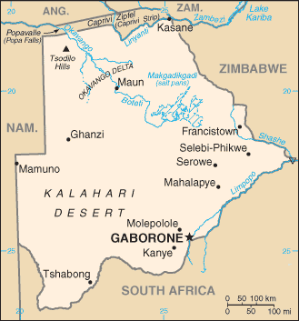 |
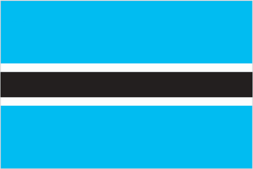
| The national flag of Botswana | Borderline map of Botswana |
| Flag description: light blue with a horizontal white-edged black stripe in the center; the blue symbolizes water in the form of rain, while the black and white bands represent racial harmony. | Border length: total: 4,347.15 km. Border countries (total: 4): Namibia 1,544 km, South Africa 1,969 km, Zambia 0.15 km, Zimbabwe 834 km. |
Did you know about Botswana?
- Botswana, originally known as British Bechuanaland, now known by its Setswana name. Independence achieved in 1966.
- Water, Botswanas most precious resource, is honored in the name of the currency pula.
- The Tswana people of Botswana traditionally live in thatched huts arranged around a courtyard.
Facts of Botswana (BW)
Name conventional long form: Republic of Botswana, conventional short form: Botswana, local long form: Republic of Botswana, local short form: Botswana, former: Bechuanaland, etymology: the name Botswana means “Land of the Tswana” – referring to the country’s major ethnic group
Codes: ISO; BW, Internet; .bw
Capital city: Gaborone
Language(s): Setswana 77.3%, Sekalanga 7.4%, Shekgalagadi 3.4%, English (official language) 2.8%, Zezuru/Shona 2%, Sesarwa 1.7%, Sembukushu 1.6%, Ndebele 1%, other 2.8% (2011 estimate)
National holiday(s): Independence Day (Botswana Day), 30 September (1966)
Motto: Pula (Rain)
Currency: Botswana pula (BWP), since 1976
GPS: 22 00 S, 24 00 E, Gaborone; 24 38 S 25 54 E
Location: Southern Africa, north of South Africa
Geography note: landlocked country; population concentrated in eastern part of the country
Land boundaries: Namibia 1,544 km, South Africa 1,969 km, Zambia 0.15 km, Zimbabwe 834 km, total: 4,347.15 km
Maritime boundaries: N/A
Coastline: 0 km (landlocked country)
Area: total: 581,730 sq km; land: 566,730 sq km, water: 15,000 sq km (total 224 711,36 mi2), slightly smaller than Texas.
Roadways: total: 17,916 km, note: includes 8,916 km of Public Highway Network roads (6,116 km paved and 2,800 km unpaved) and 9,000 km of District Council roads (2011)
Waterways: N/A
Local time (capital): UTC+2, 7 hours ahead of Washington DC during Standard Time
Note to the local time: N/A
Population in Botswana: 2 333 201
Population in Gaborone: 195 000 (including the metropolitan areas)
Urbanization: urban population: 57.4% of total population (2015)
Major urban areas population: GABORONE (capital) 247,000 (2014)
Population growth rate: 1.19% (2016 estimate)
Birth rate: 20.7 births / 1,000 population (2016 estimate)
Death rate: 13.3 deaths / 1,000 population (2016 estimate)
Age structure: 0-14 years: 32.4% (male 364,807 / female 350,888) 15-24 years: 21.32% (male 234,251 / female 236,650) 25-54 years: 37.61% (male 444,290 / female 386,622) 55-64 years: 4.55% (male 45,186 / female 55,272) 65 years and over: 4.13% (male 36,216 / female 55,026) (2016 estimate)
Median age: total: 23.2 years; male: 23.4 years, female: 23.1 years (2016 estimate)
Ethnic groups: Tswana (or Setswana) 79%, Kalanga 11%, Basarwa 3%, other, including Kgalagadi and white 7%
Religions: Christian 79.1%, Badimo 4.1%, other 1.4% (includes Baha’i, Hindu, Muslim, Rastafarian), none 15.2%, unspecified 0.3% (2011 estimate)
Government type: Parliamentary republic
Legal system: mixed legal system of civil law influenced by the Roman-Dutch model and also customary and common law
National anthem: Fatshe leno la rona (This Land of Ours)
Known national hazards: periodic droughts; seasonal August winds blow from the west, carrying sand and dust across the country, which can obscure visibility
Major infectious diseases: The The degree of risk(s): high food or waterborne diseases: bacterial diarrhea, hepatitis A, and typhoid fever vectorborne disease: malaria (2016)
Land use: agricultural land: 45.8%; arable land 0.6%; permanent crops 0%; permanent pasture 45.2%; forest: 19.8%; other: 34.4% (2011 estimate)
Agricultural products: livestock, sorghum, maize, millet, beans, sunflowers, groundnuts
Industries: diamonds, copper, nickel, salt, soda ash, potash, coal, iron ore, silver; livestock processing; textiles
Export commodities: diamonds, copper, nickel, soda ash, meat, textiles
Main export partners: N/A
Import commodities: foodstuffs, machinery, electrical goods, transport equipment, textiles, fuel and petroleum products, wood and paper products, metal and metal products
Main import partners: N/A
Navigate the countries in Africa faster and easier while driving, use the interactive Google maps for your driving directions. The continuously updated database contains over 220 countries and territories digitally mapped, hundreds of millions of businesses and places around the world positioned on the map.
Get fresh GPS navigation, traffic, and transit information – no matter what part of Botswana, Gaborone, any other city and country in Africa, or the world you’re in.
Do you like this Botswana information page? Please don’t forget to share it with others! Thank you.