Dominican Republic Google maps and Driving Directions
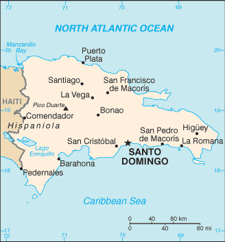
Get free driving directions, Google maps, traffic information for Dominican Republic, and Santo Domingo (GPS: 18 28 N 69 54 W), the capital city of the country located in (the) Caribbean, eastern two-thirds of the island of Hispaniola, between the Caribbean Sea and the North Atlantic Ocean, east of Haiti.
Find any address in Santo Domingo on the Google map of Dominican Republic (DO) with ease or calculate your up to date itinerary to and from Dominican Republic or its neighboring counties like Haiti.
Sightseeing and exploring in America starts here, thanks to Google because its Earth Engine combines a multi-petabyte catalog of updated satellite imagery and geospatial datasets with planetary-scale analysis capabilities. Wonder the world, use the satellite map function of the Google maps to explore or see differences on the Earth’s surface, inland, or the surrounding areas of Dominican Republic.
Google Maps Dominican Republic
The Dominican Republic occupies the eastern two-thirds of the island of Hispaniola in the Caribbean. Spanish-speaking, it seeks closer ties to the anglophone West Indies.
Dominican Republic is rugged highlands and mountains interspersed with fertile valleys.
The map above fully covers Dominican Republic with its road routes from cities to towns, road intersections in any region, provinces, prefectures, also with free driving directions in Santo Domingo or to the neighboring towns and countries. To look at the detailed map about a particular quarter in Santo Domingo, please click on the area and zoom to the place you are interested in the Google maps of Dominican Republic (DO).
Be creative, use the extras of this Google map; This is a detailed, clear, zoomable, large road map of Dominican Republic with its administrative divisions; 10 regions (regiones, singular – region); Cibao Nordeste, Cibao Noroeste, Cibao Norte, Cibao Sur, El Valle, Enriquillo, Higuamo, Ozama, Valdesia, Yuma.
The interactive map above is also may be used as the satellite map of Dominican Republic, or as a reverse search map for finding an address from its GPS coordinates.
The Dominican Republic in the West Indies occupies the eastern two-thirds of the island of Hispaniola, which it shares with Haiti. Its area equals that of Vermont and New Hampshire combined. Duarte Peak, at 10,417 ft (3,175 m), is the highest point in the West Indies.
Dominican Republic (area: 48 671 sq km / 18 791,97 sq mi), where the official language is Spanish, lying in America and using the currency; Dominican peso (DOP), since 1844, set their clock to UTC-4. That means they are 1 hour ahead of Washington DC during Standard Time in Santo Domingo, the capital. Note to the time difference: N/A.
The climate in Dominican Republic; Hot and humid close to sea level, cooler at altitude. Heavy rainfall, especially in the northeast.
Geography in a nutshell; Highlands and rainforested mountains including the highest peak in the Caribbean, Pico Duarte interspersed with fertile valleys. Extensive coastal plain in the east.
Click here for more detailed information about Dominican Republic.
Driving directions Dominican Republic
The Google maps and Google Satellite maps of Dominican Republic above showing the country, located next to Haiti. For your further reference, the latitude and longitude coordinates of Dominican Republic are 19 00 N, 70 40 W , while the capital, Santo Domingo found at 18 28 N 69 54 W.
When you are traveling around Dominican Republic, Santo Domingo, or its other cities, use this routing tool, providing up to date route planning service free of charge.
Look no further; get accurate driving directions in Dominican Republic, Central America and the Caribbean, by filling the route planner form below.
Since Google acquired and introduced its digitalized maps in 2004, you’re probably familiar with its base functions, like finding an address or driving directions to locations. Still, Google maps also accommodate bicyclists, pedestrians, and also public transportation with special directions and customizable routes.
About Dominican Republic and the capital, Santo Domingo
 |
 |
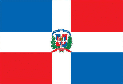
| The national flag of Dominican Republic | Borderline map of Dominican Republic |
| Flag description: a centered white cross that extends to the edges divides the flag into four rectangles – the top ones are blue (hoist side) and red, and the bottom ones are red (hoist side) and blue; a small coat of arms featuring a shield supported by a laurel branch (left) and a palm branch (right) is at the center of the cross; above the shield a blue ribbon displays the motto, DIOS, PATRIA, LIBERTAD (God, Fatherland, Liberty), and below the shield, REPUBLICA DOMINICANA appears on a red ribbon; in the shield a bible is opened to a verse that reads “Y la verdad nos hara libre” (And the truth shall set you free); blue stands for liberty, white for salvation, and red for the blood of heroes. | Border length: total: 376 km. Border countries (total: 1): Haiti 376 km. |
Did you know about Dominican Republic?
- A Spanish colony, briefly occupiedby Haiti (18201844), the Trinitarian movement was formed to free the country. Dominican Republic liberated in 1844.
- Santo Domingo is the oldest city in the Americas. It was founded in 1496 by the brother of Christopher Columbus.
- The island of Hispaniola is shared by two nations-Haiti (the first independent nation in the Caribbean) in the west and the Dominican Republic in the east.
Facts of Dominican Republic (DO)
Name conventional long form: Dominican Republic, conventional short form: The Dominican, local long form: Republica Dominicana, local short form: La Dominicana, etymology: the country name derives from the capital city of Santo Domingo (Saint Dominic)
Codes: ISO; DO, Internet; .do
Capital city: Santo Domingo
Language(s): Spanish (official language)
National holiday(s): Independence Day, 27 February (1844)
Motto: Dios, Patria y Libertad (God, Homeland, Freedom)
Currency: Dominican peso (DOP), since 1844
GPS: 19 00 N, 70 40 W, Santo Domingo; 18 28 N 69 54 W
Location: Caribbean, eastern two-thirds of the island of Hispaniola, between the Caribbean Sea and the North Atlantic Ocean, east of Haiti
Geography note: shares island of Hispaniola with Haiti (eastern two-thirds makes up the Dominican Republic, western one-third is Haiti)
Land boundaries: Haiti 376 km, total: 376 km
Maritime boundaries: N/A
Coastline: 1,288 km
Area: total: 48,670 sq km; land: 48,320 sq km, water: 350 sq km (total 18 791,97 mi2), slightly more than twice the size of New Hampshire.
Roadways: total: 19,705 km, paved: 9,872 km, unpaved: 9,833 km (2002)
Waterways: N/A
Local time (capital): UTC-4, 1 hour ahead of Washington DC during Standard Time
Note to the local time: N/A
Population in Dominican Republic: 10 882 996
Population in Santo Domingo: 2 851 300 (including the metropolitan areas)
Urbanization: urban population: 79% of total population (2015)
Major urban areas population: SANTO DOMINGO (capital) 2.945 million (2015)
Population growth rate: 1.21% (2016 estimate)
Birth rate: 18.6 births / 1,000 population (2016 estimate)
Death rate: 4.6 deaths / 1,000 population (2016 estimate)
Age structure: 0-14 years: 27.06% (male 1,460,389 / female 1,410,226) 15-24 years: 18.3% (male 989,020 / female 952,375) 25-54 years: 39.54% (male 2,146,082 / female 2,047,860) 55-64 years: 7.67% (male 409,166 / female 403,977) 65 years and over: 7.43% (male 363,791 / female 423,979) (2016 estimate)
Median age: total: 27.8 years; male: 27.6 years, female: 28 years (2016 estimate)
Ethnic groups: mixed 73%, white 16%, black 11%
Religions: Roman Catholic 95%, other 5%
Government type: Unitary presidential republic
Legal system: civil law system based on the French civil code; Criminal Procedures Code modified in 2004 to include important elements of an accusatory system
National anthem: Quisqueyanos valientes (Valiant Quisqueyans)
Known national hazards: lies in the middle of the hurricane belt and subject to severe storms from June to October; occasional flooding; periodic droughts
Major infectious diseases: The degree of risk(s): high food or waterborne diseases: bacterial diarrhea, hepatitis A, and typhoid fever vectorborne disease: dengue fever. Note: active local transmission of Zika virus by Aedes species mosquitoes has been identified in this country (as of August 2016); it poses an important risk (a large number of cases possible) among US citizens if bitten by an infective mosquito; other less common ways to get Zika are through sex, via blood transfusion, or during pregnancy, in which the pregnant woman passes Zika virus to her fetus (2016)
Land use: agricultural land: 51.5%; arable land 16.6%; permanent crops 10.1%; permanent pasture 24.8%; forest: 40.8%; other: 7.7% (2011 estimate)
Agricultural products: cocoa, tobacco, sugarcane, coffee, cotton, rice, beans, potatoes, corn, bananas; cattle, pigs, dairy products, beef, eggs
Industries: tourism, sugar processing, gold mining, textiles, cement, tobacco, electrical components, medical devices
Export commodities: gold, silver, cocoa, sugar, coffee, tobacco, meats, consumer goods
Main export partners: US 42.5%, Haiti 16.5%, Canada 8.1%, India 4.8% (2015)
Import commodities: petroleum, foodstuffs, cotton and fabrics, chemicals and pharmaceuticals
Main import partners: US 42%, China 9.2%, Venezuela 5.6%, Trinidad and Tobago 4.5%, Mexico 4.4% (2015)
Navigate the countries in Central America and the Caribbean faster and easier while driving, use the interactive Google maps for your driving directions. The continuously updated database contains over 220 countries and territories digitally mapped, hundreds of millions of businesses and places around the world positioned on the map.
Get fresh GPS navigation, traffic, and transit information – no matter what part of Dominican Republic, Santo Domingo, any other city and country in America, or the world you’re in.
Do you like this Dominican Republic information page? Please don’t forget to share it with others! Thank you.