Bulgaria Google maps and Driving Directions
Get free driving directions, Google maps, traffic information for Bulgaria, and Sofia (GPS: 42 41 N 23 19 E), the capital city of the country located in (the) Southeastern Europe, bordering the Black Sea, between Romania and Turkey.
Find any address in Sofia on the Google map of Bulgaria (BU) with ease or calculate your up to date itinerary to and from Bulgaria or its neighboring counties like Greece, Macedonia, Romania, Serbia, Turkey.
Sightseeing and exploring in Europe starts here, thanks to Google because its Earth Engine combines a multi-petabyte catalog of updated satellite imagery and geospatial datasets with planetary-scale analysis capabilities. Wonder the world, use the satellite map function of the Google maps to explore or see differences on the Earth’s surface, inland, or the surrounding areas of Bulgaria.
Google Maps Bulgaria
Located in southeastern Europe, Bulgaria was under communist rule from 1947 to 1989. Political and economic reform since then enabled it to join the EU in 2007.
Bulgaria is mostly mountains with lowlands in north and southeast.
The map above fully covers Bulgaria with its road routes from cities to towns, road intersections in any region, provinces, prefectures, also with free driving directions in Sofia or to the neighboring towns and countries. To look at the detailed map about a particular quarter in Sofia, please click on the area and zoom to the place you are interested in the Google maps of Bulgaria (BU).
Be creative, use the extras of this Google map; This is a detailed, clear, zoomable, large road map of Bulgaria with its administrative divisions; 28 provinces (oblasti, singular – oblast); Blagoevgrad, Burgas, Dobrich, Gabrovo, Haskovo, Kardzhali, Kyustendil, Lovech, Montana, Pazardzhik, Pernik, Pleven, Plovdiv, Razgrad, Ruse, Shumen, Silistra, Sliven, Smolyan, Sofia, Sofia-Grad (Sofia City), Stara Zagora, Targovishte, Varna, Veliko Tarnovo, Vidin, Vratsa, Yambol.
The interactive map above is also may be used as the satellite map of Bulgaria, or as a reverse search map for finding an address from its GPS coordinates.
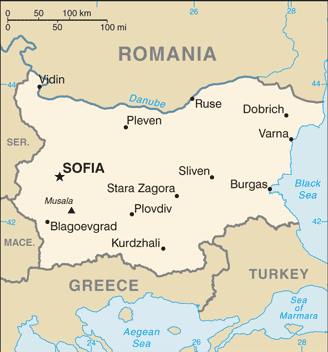
Bulgaria shares borders with Serbia, Macedonia, Romania, Greece, and Turkey. Two mountain ranges and two great valleys mark the topography of Bulgaria, a country the size of Tennessee and situated on the Black Sea. The Maritsa is Bulgaria’s principal river, the Danube also flows through the country.
Bulgaria (area: 110 879 sq km / 42 810,60 sq mi), where the official language is Bulgarian, lying in Europe and using the currency; Bulgarian lev (BGN), since 1999, set their clock to UTC+2. That means they are 7 hours ahead of Washington DC during Standard Time in Sofia, the capital. Note to the time difference: Daylight saving time: +1hr begins last Sunday in March; ends last Sunday in October.
The climate in Bulgaria; Warm summers and snowy winters, especially in mountains. East winds bring seasonal extremes.
Geography in a nutshell; Mountains run eastwest across center and along southern border. Danube plain in north, Thracian plain in southeast. Black Sea to the east.
Click here for more detailed information about Bulgaria.
Driving directions Bulgaria
The Google maps and Google Satellite maps of Bulgaria above showing the country, located next to Greece, Macedonia, Romania, Serbia, Turkey. For your further reference, the latitude and longitude coordinates of Bulgaria are 43 00 N, 25 00 E , while the capital, Sofia found at 42 41 N 23 19 E.
When you are traveling around Bulgaria, Sofia, or its other cities, use this routing tool, providing up to date route planning service free of charge.
Look no further; get accurate driving directions in Bulgaria, Europe, by filling the route planner form below.
Since Google acquired and introduced its digitalized maps in 2004, you’re probably familiar with its base functions, like finding an address or driving directions to locations. Still, Google maps also accommodate bicyclists, pedestrians, and also public transportation with special directions and customizable routes.
About Bulgaria and the capital, Sofia
 |
 |
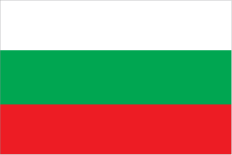
| The national flag of Bulgaria | Borderline map of Bulgaria |
| Flag description: three equal horizontal bands of white (top), green, and red; the pan-Slavic white-blue-red colors were modified by substituting a green band (representing freedom) for the blue. Note: the national emblem, formerly on the hoist side of the white stripe, has been removed. | Border length: total: 1,806 km. Border countries (total: 5): Greece 472 km, Macedonia 162 km, Romania 605 km, Serbia 344 km, Turkey 223 km. |
About Sofia
With its drab suburbs and distinct lack of charming old buildings, Sofia (София) can seem an uninspiring place to first-time visitors. Yet once you’ve settled in and begun to explore, you’ll find it a surprisingly vibrant city, especially on fine days, when its lush public gardens and pavement cafés buzz with life. Just 8km to the south looms verdant Mount Vitosha, promising fantastic hiking, biking, and skiing. Sofia was founded by a Thracian tribe some three thousand years ago, and various Roman ruins attest to its zenith as Serdika, a regional imperial capital in the fourth century AD.
The Bulgars didn’t arrive on the scene until the ninth century, and, with the notable exception of the thirteenthcentury Boyana Church, their cultural monuments largely disappeared during Ottoman rule (1396–1878). The architectural legacy of the Ottomans was mostly eradicated following liberation in 1878 and is now visible solely in a couple of stately mosques. The finest architecture postdates Bulgaria’s liberation: handsome Neoclassical buildings, imposing Soviet-era government offices, vast parks, and the magnificent Aleksandar Nevski Cathedral.
Did you know about Bulgaria?
- Bulgaria became independent in 1908 after 500 years of Ottoman rule. In 1990, the communist regime, in power since 1946, collapsed.
- Archaeologists have found evidence of wine-making in Bulgaria dating back over 5000 years.
- Greece and Bulgaria are Orthodox Christian nations and both use the Cyrillic script to write rather than the Latin script common to most other European countries.
Bulgaria is bounded on the west by Yugoslavia, in the southwest by Macedonia, in the south by Greece, in the southeast by Turkey and in the north, by Romania. The River Danube (Dunav) flows along Bulgaria’s northern boundary, and in the east the country borders the Black Sea – a popular area for tourists.
Hills or mountains cover about half the country with a ‘finger’ of the Balkan Mountains, the Stara Planina, extending eastwards from the northwest of the country. In the south, the Rhodopi Mountains straddle the border with Greece. Sofiya, the country’s capital, is situated in the western central region of the country as is the Rila mountain chain.
Farming is responsible for about 16 percent of the country’s national wealth, but manufacturing and industrial processes are the largest contributors to the Bulgarian economy. The country has some valuable mineral reserves, including coal, iron ore, lead, zinc, copper, and manganese but oil has to be imported. Coal mining, the production of iron ore and other minerals, fishing, forestry, and tourism are other significant contributors to the economy.
Facts of Bulgaria (BU)
Name conventional long form: Republic of Bulgaria, conventional short form: Bulgaria, local long form: Republika Bulgaria, local short form: Bulgaria, etymology: named after the Bulgar tribes who settled the lower Balkan region in the 7th century A.D.
Codes: ISO; BU, Internet; .bg
Capital city: Sofia
Language(s): Bulgarian (official language) 76.8%, Turkish 8.2%, Roma 3.8%, other 0.7%, unspecified 10.5% (2011 estimate)
National holiday(s): Liberation Day, 3 March (1878)
Motto: Unity makes strength
Currency: Bulgarian lev (BGN), since 1999
GPS: 43 00 N, 25 00 E, Sofia; 42 41 N 23 19 E
Location: Southeastern Europe, bordering the Black Sea, between Romania and Turkey
Geography note: strategic location near Turkish Straits; controls key land routes from Europe to Middle East and Asia
Land boundaries: Greece 472 km, Macedonia 162 km, Romania 605 km, Serbia 344 km, Turkey 223 km, total: 1,806 km
Maritime boundaries: N/A
Coastline: 354 km
Area: total: 110,879 sq km; land: 108,489 sq km, water: 2,390 sq km (total 42 810,60 mi2), slightly larger than Tennessee.
Roadways: total: 19,512 km, paved: 19,235 km (includes 458 km of expressways), unpaved: 277 km, note: does not include Category IV local roads (2011)
Waterways: 470 km (2009)
Local time (capital): UTC+2, 7 hours ahead of Washington DC during Standard Time
Note to the local time: Daylight saving time: +1hr begins last Sunday in March; ends last Sunday in October
Population in Bulgaria: 7 036 848
Population in Sofia: 1 088 700 (including the metropolitan areas)
Urbanization: urban population: 73.9% of total population (2015)
Major urban areas population: SOFIA (capital) 1.226 million (2015)
Population growth rate: -0.6% (2016 estimate)
Birth rate: 8.8 births / 1,000 population (2016 estimate)
Death rate: 14.5 deaths / 1,000 population (2016 estimate)
Age structure: 0-14 years: 14.54% (male 535,131 / female 503,540) 15-24 years: 9.73% (male 362,805 / female 332,358) 25-54 years: 43.33% (male 1,589,183 / female 1,506,285) 55-64 years: 13.38% (male 447,865 / female 507,805) 65 years and over: 19.03% (male 552,217 / female 807,464) (2016 estimate)
Median age: total: 42.4 years; male: 40.6 years, female: 44.5 years (2016 estimate)
Ethnic groups: Bulgarian 76.9%, Turkish 8%, Roma 4.4%, other 0.7% (including Russian, Armenian, and Vlach), other (unknown) 10% (2011 estimate)
Religions: Eastern Orthodox 59.4%, Muslim 7.8%, other (including Catholic, Protestant, Armenian Apostolic Orthodox, and Jewish) 1.7%, none 3.7%, unspecified 27.4% (2011 estimate)
Government type: Unitary parliamentary republic
Legal system: civil law
National anthem: Mila Rodino
Known national hazards: earthquakes; landslides
Major infectious diseases: N/A
Land use: agricultural land: 46.9%; arable land 29.9%; permanent crops 1.5%; permanent pasture 15.5%; forest: 36.7%; other: 16.4% (2011 estimate)
Agricultural products: vegetables, fruits, tobacco, wine, wheat, barley, sunflowers, sugar beets; livestock
Industries: electricity, gas, water; food, beverages, tobacco; machinery and equipment, base metals, chemical products, coke, refined petroleum, nuclear fuel
Export commodities: clothing, footwear, iron and steel, machinery and equipment, fuels
Main export partners: Germany 12.5%, Italy 9.2%, Turkey 8.5%, Romania 8.2%, Greece 6.5%, France 4.2% (2015)
Import commodities: machinery and equipment; metals and ores; chemicals and plastics; fuels, minerals, and raw materials
Main import partners: Germany 12.9%, Russia 12%, Italy 7.6%, Romania 6.8%, Turkey 5.7%, Greece 4.8%, Spain 4.8% (2015)
Navigate the countries in Europe faster and easier while driving, use the interactive Google maps for your driving directions. The continuously updated database contains over 220 countries and territories digitally mapped, hundreds of millions of businesses and places around the world positioned on the map.
Get fresh GPS navigation, traffic, and transit information – no matter what part of Bulgaria, Sofia, any other city and country in Europe, or the world you’re in.
Do you like this Bulgaria information page? Please don’t forget to share it with others! Thank you.