Burkina Faso Google maps and Driving Directions
Get free driving directions, Google maps, traffic information for Burkina Faso, and Ouagadougou (GPS: 12 22 N 1 31 W), the capital city of the country located in (the) Western Africa, north of Ghana.
Find any address in Ouagadougou on the Google map of Burkina Faso (BF) with ease or calculate your up to date itinerary to and from Burkina Faso or its neighboring counties like Benin, Ghana, Ivory Coast, Mali, Niger, Togo.
Sightseeing and exploring in Africa starts here, thanks to Google because its Earth Engine combines a multi-petabyte catalog of updated satellite imagery and geospatial datasets with planetary-scale analysis capabilities. Wonder the world, use the satellite map function of the Google maps to explore or see differences on the Earth’s surface, inland, or the surrounding areas of Burkina Faso.
Google Maps Burkina Faso
The west African state of Burkina was known as Upper Volta until 1984. It became a multiparty state in 1991, though former military ruler Blaise Compaoré remains in power.
Burkina Faso is mostly flat to dissected, undulating plains; hills in west and southeast.
The map above fully covers Burkina Faso with its road routes from cities to towns, road intersections in any region, provinces, prefectures, also with free driving directions in Ouagadougou or to the neighboring towns and countries. To look at the detailed map about a particular quarter in Ouagadougou, please click on the area and zoom to the place you are interested in the Google maps of Burkina Faso (BF).
Be creative, use the extras of this Google map; This is a detailed, clear, zoomable, large road map of Burkina Faso with its administrative divisions; 13 regions; Boucle du Mouhoun, Cascades, Centre, Centre-Est, Centre-Nord, Centre-Ouest, Centre-Sud, Est, Hauts-Bassins, Nord, Plateau-Central, Sahel, Sud-Ouest.
The interactive map above is also may be used as the satellite map of Burkina Faso, or as a reverse search map for finding an address from its GPS coordinates.
Slightly larger than Colorado, Burkina Faso, formerly known as Upper Volta, is a landlocked country in West Africa. Its neighbors are Côte d’Ivoire, Mali, Niger, Benin, Togo, and Ghana. The country consists of extensive plains, low hills, high savannas, and a desert area in the north.
Burkina Faso (area: 272 967 sq km / 105 393,10 sq mi), where the official language is French, lying in Africa and using the currency; West African CFA franc (XOF), set their clock to UTC 0. That means they are 5 hours ahead of Washington DC during Standard Time in Ouagadougou, the capital. Note to the time difference: N/A.
The climate in Burkina Faso; Tropical. Dry, cool weather NovemberFebruary. Erratic rain MarchApril, mostly in southeast.
Geography in a nutshell; The Sahara covers the north of the country. The south is largely savanna. The three main rivers are the Black, White, and Red Voltas.
Click here for more detailed information about Burkina Faso.
Driving directions Burkina Faso
The Google maps and Google Satellite maps of Burkina Faso above showing the country, located next to Benin, Ghana, Ivory Coast, Mali, Niger, Togo. For your further reference, the latitude and longitude coordinates of Burkina Faso are 13 00 N, 2 00 W , while the capital, Ouagadougou found at 12 22 N 1 31 W.
When you are traveling around Burkina Faso, Ouagadougou, or its other cities, use this routing tool, providing up to date route planning service free of charge.
Look no further; get accurate driving directions in Burkina Faso, Africa, by filling the route planner form below.
Since Google acquired and introduced its digitalized maps in 2004, you’re probably familiar with its base functions, like finding an address or driving directions to locations. Still, Google maps also accommodate bicyclists, pedestrians, and also public transportation with special directions and customizable routes.
About Burkina Faso and the capital, Ouagadougou
 |
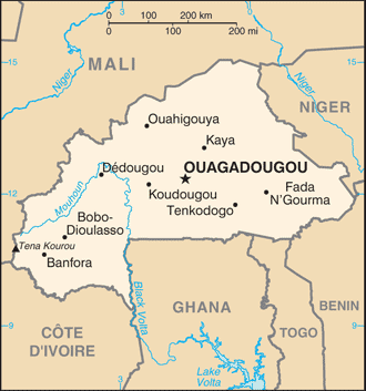 |
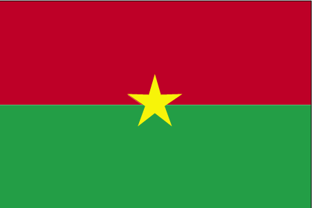
| The national flag of Burkina Faso | Borderline map of Burkina Faso |
| Flag description: two equal horizontal bands of red (top) and green with a yellow five-pointed star in the center; red recalls the country’s struggle for independence, green is for hope and abundance, and yellow represents the country’s mineral wealth. Note: uses the popular Pan-African colors of Ethiopia. | Border length: total: 3,611 km. Border countries (total: 6): Benin 386 km, Cote d’Ivoire 545 km, Ghana 602 km, Mali 1,325 km, Niger 622 km, Togo 131 km. |
Did you know about Burkina Faso?
- Burkina, originally known as Upper Volta, was once a French colony. It became self-governing in 1958 and fully independent in 1960.
- Droughts and poor soils mean that many Burkinabes seek work southward in Ghana and Côte dIvoire.
- Humped zebu cattle, goats, sheep, and camels are the main animals kept by Burkinas farmers.
Facts of Burkina Faso (BF)
Name conventional long form: none, conventional short form: Burkina Faso, local long form: none, local short form: Burkina Faso, former: Upper Volta, Republic of Upper Volta, etymology: name translates as “Land of the honest (incorruptible) men”
Codes: ISO; BF, Internet; .bf
Capital city: Ouagadougou
Language(s): French (official language), native African languages belonging to Sudanic family spoken by 90% of the population
National holiday(s): Republic Day, 11 December (1958)
Motto: Unité, Progrés, Justice (Unity, Progress, Justice)
Currency: West African CFA franc (XOF)
GPS: 13 00 N, 2 00 W, Ouagadougou; 12 22 N 1 31 W
Location: Western Africa, north of Ghana
Geography note: landlocked savanna cut by the three principal rivers of the Black, Red, and White Voltas
Land boundaries: Benin 386 km, Cote d’Ivoire 545 km, Ghana 602 km, Mali 1,325 km, Niger 622 km, Togo 131 km, total: 3,611 km
Maritime boundaries: N/A
Coastline: 0 km (landlocked country)
Area: total: 274,200 sq km; land: 273,800 sq km, water: 400 sq km (total 105 393,10 mi2), slightly larger than Colorado.
Roadways: total: 15,272 km, note: does not include urban roads (2010)
Waterways: N/A
Local time (capital): UTC 0, 5 hours ahead of Washington DC during Standard Time
Note to the local time: N/A
Population in Burkina Faso: 19 751 651
Population in Ouagadougou: 962 100 (including the metropolitan areas)
Urbanization: urban population: 29.9% of total population (2015)
Major urban areas population: OUAGADOUGOU (capital) 2.741 million (2015)
Population growth rate: 3.01% (2016 estimate)
Birth rate: 41.6 births / 1,000 population (2016 estimate)
Death rate: 11.5 deaths / 1,000 population (2016 estimate)
Age structure: 0-14 years: 45.04% (male 4,402,311 / female 4,386,518) 15-24 years: 20.08% (male 1,966,644 / female 1,951,722) 25-54 years: 29.28% (male 2,898,407 / female 2,813,923) 55-64 years: 3.16% (male 267,763 / female 349,433) 65 years and over: 2.44% (male 178,127 / female 297,685) (2016 estimate)
Median age: total: 17.2 years; male: 17 years, female: 17.3 years (2016 estimate)
Ethnic groups: Mossi 52.5%, Fulani 8.4%, Gurma 6.8%, Bobo 4.8%, Gurunsi 4.5%, Senufo 4.4%, Bissa 3.9%, Lobi 2.5%, Dagara 2.4%, Tuareg/Bella 1.9%, Dioula 0.8%, unspecified/no answer 0.1%, other 7% (2010 estimate)
Religions: Muslim 61.6%, Catholic 23.2%, traditional/animist 7.3%, Protestant 6.7%, other/no answer 0.2%, none 0.9% (2010 estimate)
Government type: Unitary semi-presidential republic
Legal system: civil law based on the French model and customary law
National anthem: Ditanyé (One Single Night / Hymn of Victory)
Known national hazards: recurring droughts
Major infectious diseases: The The degree of risk(s): very high food or waterborne diseases: bacterial and protozoal diarrhea, hepatitis A, and typhoid fever vectorborne disease: dengue fever, malaria, and yellow feverwater contact disease: schistosomiasisrespiratory disease: meningococcal meningitisanimal contact disease: rabies (2016)
Land use: agricultural land: 43%; arable land 20.8%; permanent crops 0.3%; permanent pasture 21.9%; forest: 20.4%; other: 36.6% (2011 estimate)
Agricultural products: cotton, peanuts, shea nuts, sesame, sorghum, millet, corn, rice; livestock
Industries: cotton lint, beverages, agricultural processing, soap, cigarettes, textiles, gold
Export commodities: gold, cotton, livestock
Main export partners: Switzerland 53.3%, India 14.5% (2015)
Import commodities: capital goods, foodstuffs, petroleum
Main import partners: Cote dIvoire 23.1%, France 11.1%, Togo 7.5%, China 4.8%, Ghana 4.6% (2015)
Navigate the countries in Africa faster and easier while driving, use the interactive Google maps for your driving directions. The continuously updated database contains over 220 countries and territories digitally mapped, hundreds of millions of businesses and places around the world positioned on the map.
Get fresh GPS navigation, traffic, and transit information – no matter what part of Burkina Faso, Ouagadougou, any other city and country in Africa, or the world you’re in.
Do you like this Burkina Faso information page? Please don’t forget to share it with others! Thank you.