Gabon Google maps and Driving Directions
Get free driving directions, Google maps, traffic information for Gabon, and Libreville (GPS: 0 23 N 9 27 E), the capital city of the country located in (the) Central Africa, bordering the Atlantic Ocean at the Equator, between Republic of the Congo and Equatorial Guinea.
Find any address in Libreville on the Google map of Gabon (GA) with ease or calculate your up to date itinerary to and from Gabon or its neighboring counties like Cameroon, Equatorial Guinea, Republic of the Congo.
Sightseeing and exploring in Africa starts here, thanks to Google because its Earth Engine combines a multi-petabyte catalog of updated satellite imagery and geospatial datasets with planetary-scale analysis capabilities. Wonder the world, use the satellite map function of the Google maps to explore or see differences on the Earth’s surface, inland, or the surrounding areas of Gabon.
Google Maps Gabon
Gabon is a former French colony straddling the equator on Africas west coast. Independent since 1960, it returned to multiparty politics in 1990, after 22 years of one-party rule.
Gabon is narrow coastal plain; hilly interior; savanna in east and south.
The map above fully covers Gabon with its road routes from cities to towns, road intersections in any region, provinces, prefectures, also with free driving directions in Libreville or to the neighboring towns and countries. To look at the detailed map about a particular quarter in Libreville, please click on the area and zoom to the place you are interested in the Google maps of Gabon (GA).
Be creative, use the extras of this Google map; This is a detailed, clear, zoomable, large road map of Gabon with its administrative divisions; 9 provinces; Estuaire, Haut-Ogooue, Moyen-Ogooue, Ngounie, Nyanga, Ogooue-Ivindo, Ogooue-Lolo, Ogooue-Maritime, Woleu-Ntem.
The interactive map above is also may be used as the satellite map of Gabon, or as a reverse search map for finding an address from its GPS coordinates.
This West African country with the Atlantic as its western border is also bounded by Equatorial Guinea, Cameroon, and the Congo. Its area is slightly less than Colorado’s. A dense tropical forest covers most of the country.
Gabon (area: 267 668 sq km / 103 347,15 sq mi), where the official language is French, lying in Africa and using the currency; Central African CFA franc (XAF), set their clock to UTC+1. That means they are 6 hours ahead of Washington DC during Standard Time in Libreville, the capital. Note to the time difference: N/A.
The climate in Gabon; Hot and tropical, with little distinction between seasons. Cold Benguela current cools the coast.
Geography in a nutshell; Low plateaus and mountains lie beyond the coastal strip. Two-thirds of the land is covered by rainforest.
Click here for more detailed information about Gabon.
Driving directions Gabon
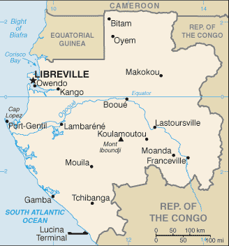
The Google maps and Google Satellite maps of Gabon above showing the country, located next to Cameroon, Equatorial Guinea, Republic of the Congo. For your further reference, the latitude and longitude coordinates of Gabon are 1 00 S, 11 45 E , while the capital, Libreville found at 0 23 N 9 27 E.
When you are traveling around Gabon, Libreville, or its other cities, use this routing tool, providing up to date route planning service free of charge.
Look no further; get accurate driving directions in Gabon, Africa, by filling the route planner form below.
Since Google acquired and introduced its digitalized maps in 2004, you’re probably familiar with its base functions, like finding an address or driving directions to locations. Still, Google maps also accommodate bicyclists, pedestrians, and also public transportation with special directions and customizable routes.
About Gabon and the capital, Libreville
 |
 |
| The national flag of Gabon | Borderline map of Gabon |
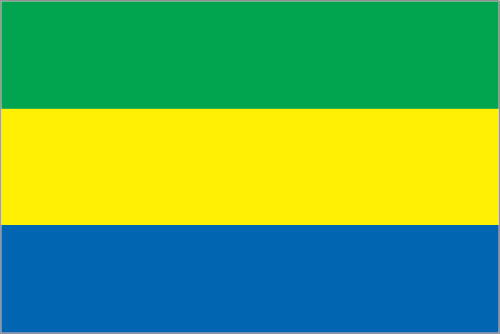
| Flag description: three equal horizontal bands of green (top), yellow, and blue; green represents the country’s forests and natural resources, gold represents the equator (which transects Gabon) as well as the sun, blue represents the sea. | Border length: total: 3,261 km. Border countries (total: 3): Cameroon 349 km, Republic of the Congo 2,567 km, Equatorial Guinea 345 km. |
Did you know about Gabon?
- Gabon was once a province of French Equatorial Africa. It became independent in 1960 under the leadership of the Gabon Democratic Party.
- Libreville founded as a settlement for freed French slaves in 1849.
- Two-thirds of Gabon is untouched tropical rain forest, and huge national parks have been set up to protect this important habitat.
Facts of Gabon (GA)
Name conventional long form: Gabonese Republic, conventional short form: Gabon, local long form: Republique Gabonaise, local short form: Gabon, etymology: name originates from the Portuguese word “gabao” meaning “cloak,” which is roughly the shape that the early explorers gave to the estuary of the Komo River by the capital of Libreville
Codes: ISO; GA, Internet; .ga
Capital city: Libreville
Language(s): French (official language), Fang, Myene, Nzebi, Bapounou/Eschira, Bandjabi
National holiday(s): Independence Day, 17 August (1960)
Motto: Union, Travail, Justice (Union, Work, Justice)
Currency: Central African CFA franc (XAF)
GPS: 1 00 S, 11 45 E, Libreville; 0 23 N 9 27 E
Location: Central Africa, bordering the Atlantic Ocean at the Equator, between Republic of the Congo and Equatorial Guinea
Geography note: a small population and oil and mineral reserves have helped Gabon become one of Africa’s wealthier countries; in general, these circumstances have allowed the country to maintain and conserve its pristine rain forest and rich biodiversity
Land boundaries: Cameroon 349 km, Republic of the Congo 2,567 km, Equatorial Guinea 345 km, total: 3,261 km
Maritime boundaries: N/A
Coastline: 885 km
Area: total: 267,667 sq km; land: 257,667 sq km, water: 10,000 sq km (total 103 347,15 mi2), slightly smaller than Colorado.
Roadways: total: 9,170 km, paved: 1,097 km, unpaved: 8,073 km (2007)
Waterways: 1,600 km (310 km on Ogooue River) (2010)
Local time (capital): UTC+1, 6 hours ahead of Washington DC during Standard Time
Note to the local time: N/A
Population in Gabon: 2 067 561
Population in Libreville: 661 600 (including the metropolitan areas)
Urbanization: urban population: 87.2% of total population (2015)
Major urban areas population: LIBREVILLE (capital) 707,000 (2015)
Population growth rate: 1.92% (2016 estimate)
Birth rate: 34.3 births / 1,000 population (2016 estimate)
Death rate: 13.1 deaths / 1,000 population (2016 estimate)
Age structure: 0-14 years: 41.98% (male 366,875 / female 363,031) 15-24 years: 20.37% (male 177,501 / female 176,653) 25-54 years: 29.59% (male 257,841 / female 256,604) 55-64 years: 4.28% (male 35,895 / female 38,533) 65 years and over: 3.77% (male 28,137 / female 37,471) (2016 estimate)
Median age: total: 18.6 years; male: 18.4 years, female: 18.8 years (2016 estimate)
Ethnic groups: Bantu tribes, including four major tribal groupings (Fang, Bapounou, Nzebi, Obamba); other Africans and Europeans, 154,000, including 10,700 French and 11,000 persons of dual nationality
Religions: Catholic 41.9%, Protestant 13.7%, other Christian 32.4%, Muslim 6.4%, animist 0.3%, other 0.3%, none/no answer 5% (2012 estimate)
Government type: Presidential republic
Legal system: mixed legal system of French civil law and customary law
National anthem: La Concorde
Known national hazards: N/A
Major infectious diseases: The degree of risk(s): very high food or waterborne diseases: bacterial diarrhea, hepatitis A, and typhoid fever vectorborne disease: malaria and dengue feverwater contact disease: schistosomiasis animal contact disease: rabies (2016)
Land use: agricultural land: 19%; arable land 1.2%; permanent crops 0.6%; permanent pasture 17.2%; forest: 81%; other: 0% (2011 estimate)
Agricultural products: cocoa, coffee, sugar, palm oil, rubber; cattle; okoume (a tropical softwood); fish
Industries: petroleum extraction and refining; manganese, gold; chemicals, ship repair, food and beverages, textiles, lumbering and plywood, cement
Export commodities: crude oil, timber, manganese, uranium
Main export partners: China 15.5%, Italy 7.3%, Trinidad and Tobago 7.2%, Australia 7%, Spain 6.3%, South Korea 5.4%, Netherlands 5%, US 4.7% (2015)
Import commodities: machinery and equipment, foodstuffs, chemicals, construction materials
Main import partners: China 21.4%, France 19.6%, US 6.6%, Benin 4.7%, Netherlands 4% (2015)
Navigate the countries in Africa faster and easier while driving, use the interactive Google maps for your driving directions. The continuously updated database contains over 220 countries and territories digitally mapped, hundreds of millions of businesses and places around the world positioned on the map.
Get fresh GPS navigation, traffic, and transit information – no matter what part of Gabon, Libreville, any other city and country in Africa, or the world you’re in.
Do you like this Gabon information page? Please don’t forget to share it with others! Thank you.