Ghana Google maps and Driving Directions
Get free driving directions, Google maps, traffic information for Ghana, and Accra (GPS: 5 33 N 0 13 W), the capital city of the country located in (the) Western Africa, bordering the Gulf of Guinea, between Cote d’Ivoire and Togo.
Find any address in Accra on the Google map of Ghana (GH) with ease or calculate your up to date itinerary to and from Ghana or its neighboring counties like Burkina Faso, Ivory Coast, Togo.
Sightseeing and exploring in Africa starts here, thanks to Google because its Earth Engine combines a multi-petabyte catalog of updated satellite imagery and geospatial datasets with planetary-scale analysis capabilities. Wonder the world, use the satellite map function of the Google maps to explore or see differences on the Earth’s surface, inland, or the surrounding areas of Ghana.
Google Maps Ghana
The heartland of the ancient Ashanti kingdom, Ghana in west Africa was once known as the Gold Coast. It has experienced intermittent periods of military rule since independence in 1957.
Ghana is mostly low plains with dissected plateau in south-central area.
The map above fully covers Ghana with its road routes from cities to towns, road intersections in any region, provinces, prefectures, also with free driving directions in Accra or to the neighboring towns and countries. To look at the detailed map about a particular quarter in Accra, please click on the area and zoom to the place you are interested in the Google maps of Ghana (GH).
Be creative, use the extras of this Google map; This is a detailed, clear, zoomable, large road map of Ghana with its administrative divisions; 10 regions; Ashanti, Brong-Ahafo, Central, Eastern, Greater Accra, Northern, Upper East, Upper West, Volta, Western.
The interactive map above is also may be used as the satellite map of Ghana, or as a reverse search map for finding an address from its GPS coordinates.
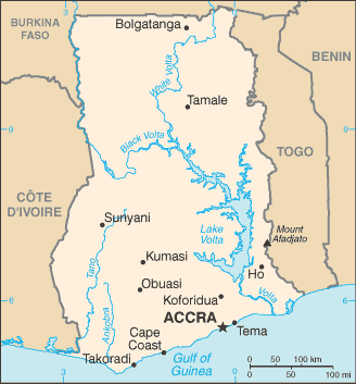
A West African country bordering on the Gulf of Guinea, Ghana is bounded by Côte d’Ivoire to the west, Burkina Faso to the north, Togo to the east, and the Atlantic Ocean to the south. It compares in size to Oregon, and its largest river is the Volta.
Ghana (area: 238 533 sq km / 92 098,07 sq mi), where the official language is English, lying in Africa and using the currency; Ghanaian cedi (GHS), since 1965, set their clock to UTC 0. That means they are 5 hours ahead of Washington DC during Standard Time in Accra, the capital. Note to the time difference: N/A.
The climate in Ghana; Tropical. There are two wet seasons in the south, but the north is drier, and has just one.
Geography in a nutshell; Mostly low-lying. The west is covered by rainforest. One of the worlds largest artificial lakes Lake Volta was created by damming the White Volta River.
Click here for more detailed information about Ghana.
Driving directions Ghana
The Google maps and Google Satellite maps of Ghana above showing the country, located next to Burkina Faso, Ivory Coast, Togo. For your further reference, the latitude and longitude coordinates of Ghana are 8 00 N, 2 00 W , while the capital, Accra found at 5 33 N 0 13 W.
When you are traveling around Ghana, Accra, or its other cities, use this routing tool, providing up to date route planning service free of charge.
Look no further; get accurate driving directions in Ghana, Africa, by filling the route planner form below.
Since Google acquired and introduced its digitalized maps in 2004, you’re probably familiar with its base functions, like finding an address or driving directions to locations. Still, Google maps also accommodate bicyclists, pedestrians, and also public transportation with special directions and customizable routes.
About Ghana and the capital, Accra
 |
 |
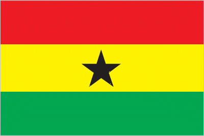
| The national flag of Ghana | Borderline map of Ghana |
| Flag description: three equal horizontal bands of red (top), yellow, and green, with a large black five-pointed star centered in the yellow band; red symbolizes the bloodshed for independence, yellow represents the country’s mineral wealth, while green stands for its forests and natural wealth; the black star is said to be the lodestar of African freedom. Note: uses the popular Pan-African colors of Ethiopia; similar to the flag of Bolivia, which has a coat of arms centered in the yellow band. | Border length: total: 2,420 km. Border countries (total: 3): Burkina Faso 602 km, Cote d’Ivoire 720 km, Togo 1,098 km. |
Did you know about Ghana?
- Previously the Gold Coast, Ghana became independent from Britain in 1957. It took its new name from that of an historic African empire.
- Ghana was the first colony in west Africa to gain independence.
- Africas second-biggest producer of gold, Ghana exports this precious metal along with diamonds, bauxite, and manganese.
Facts of Ghana (GH)
Name conventional long form: Republic of Ghana, conventional short form: Ghana, former: Gold Coast, etymology: named for the medieval West African kingdom of the same name, but whose location was actually further north than the modern country
Codes: ISO; GH, Internet; .gh
Capital city: Accra
Language(s): Asante 16%, Ewe 14%, Fante 11.6%, Boron (Brong) 4.9%, Dagomba 4.4%, Dangme 4.2%, Dagarte (Dagaba) 3.9%, Kokomba 3.5%, Akyem 3.2%, Ga 3.1%, other 31.2%. Note: English is the official language language (2010 estimate)
National holiday(s): Independence Day, 6 March (1957)
Motto: Freedom and Justice
Currency: Ghanaian cedi (GHS), since 1965
GPS: 8 00 N, 2 00 W, Accra; 5 33 N 0 13 W
Location: Western Africa, bordering the Gulf of Guinea, between Cote d’Ivoire and Togo
Geography note: Lake Volta is the world’s largest artificial lake (manmade reservoir) by surface area (8,482 sq km; 3,275 sq mi); the lake was created following the completion of the Akosombo Dam in 1965, which holds back the White Volta and Black Volta Rivers
Land boundaries: Burkina Faso 602 km, Cote d’Ivoire 720 km, Togo 1,098 km, total: 2,420 km
Maritime boundaries: N/A
Coastline: 539 km
Area: total: 238,533 sq km; land: 227,533 sq km, water: 11,000 sq km (total 92 098,07 mi2), slightly smaller than Oregon.
Roadways: total: 109,515 km, paved: 13,787 km, unpaved: 95,728 km (2009)
Waterways: 1,293 km (168 km for launches and lighters on Volta, Ankobra, and Tano Rivers; 1,125 km of arterial and feeder waterways on Lake Volta) (2011)
Local time (capital): UTC 0, 5 hours ahead of Washington DC during Standard Time
Note to the local time: N/A
Population in Ghana: 29 463 643
Population in Accra: 2 825 800 (including the metropolitan areas)
Urbanization: urban population: 54% of total population (2015)
Major urban areas population: Kumasi 2.599 million; ACCRA (capital) 2.277 million (2015)
Population growth rate: 2.18% (2016 estimate)
Birth rate: 30.8 births / 1,000 population (2016 estimate)
Death rate: 7.1 deaths / 1,000 population (2016 estimate)
Age structure: 0-14 years: 38.2% (male 5,164,505 / female 5,113,185) 15-24 years: 18.66% (male 2,498,185 / female 2,522,353) 25-54 years: 34.05% (male 4,445,321 / female 4,716,311) 55-64 years: 4.91% (male 642,984 / female 678,784) 65 years and over: 4.19% (male 520,589 / female 606,045) (2016 estimate)
Median age: total: 21 years; male: 20.5 years, female: 21.5 years (2016 estimate)
Ethnic groups: Akan 47.5%, Mole-Dagbon 16.6%, Ewe 13.9%, Ga-Dangme 7.4%, Gurma 5.7%, Guan 3.7%, Grusi 2.5%, Mande 1.1%, other 1.4% (2010 estimate)
Religions: Christian 71.2% (Pentecostal/Charismatic 28.3%, Protestant 18.4%, Catholic 13.1%, other 11.4%), Muslim 17.6%, traditional 5.2%, other 0.8%, none 5.2% (2010 estimate)
Government type: Unitary presidential constitutional republic
Legal system: mixed system of English common law and customary law
National anthem: God Bless Our Homeland Ghana
Known national hazards: dry, dusty, northeastern harmattan winds from January to March; droughts
Major infectious diseases: The degree of risk(s): very high food or waterborne diseases: bacterial and protozoal diarrhea, hepatitis A, and typhoid fever vectorborne diseases: malaria, dengue fever, and yellow feverwater contact disease: schistosomiasisrespiratory disease: meningococcal meningitisanimal contact disease: rabies (2016)
Land use: agricultural land: 69.1%; arable land 20.7%; permanent crops 11.9%; permanent pasture 36.5%; forest: 21.2%; other: 9.7% (2011 estimate)
Agricultural products: cocoa, rice, cassava (manioc, tapioca), peanuts, corn, shea nuts, bananas; timber
Industries: mining, lumbering, light manufacturing, aluminum smelting, food processing, cement, small commercial ship building, petroleum
Export commodities: oil, gold, cocoa, timber, tuna, bauxite, aluminum, manganese ore, diamonds, horticultural products
Main export partners: India 25.2%, Switzerland 12.2%, China 10.6%, France 5.7% (2015)
Import commodities: capital equipment, refined petroleum, foodstuffs
Main import partners: China 32.6%, Nigeria 14%, Netherlands 5.5%, US 5.4% (2015)
Navigate the countries in Africa faster and easier while driving, use the interactive Google maps for your driving directions. The continuously updated database contains over 220 countries and territories digitally mapped, hundreds of millions of businesses and places around the world positioned on the map.
Get fresh GPS navigation, traffic, and transit information – no matter what part of Ghana, Accra, any other city and country in Africa, or the world you’re in.
Do you like this Ghana information page? Please don’t forget to share it with others! Thank you.