Zambia Google maps and Driving Directions
Get free driving directions, Google maps, traffic information for Zambia, and Lusaka (GPS: 15 25 S 28 17 E), the capital city of the country located in (the) Southern Africa, east of Angola, south of the Democratic Republic of the Congo.
Find any address in Lusaka on the Google map of Zambia (ZM) with ease or calculate your up to date itinerary to and from Zambia or its neighboring counties like Angola, Botswana, Democratic Republic of Congo, Malawi, Mozambique, Namibia, Tanzania, Zimbabwe.
Sightseeing and exploring in Africa starts here, thanks to Google because its Earth Engine combines a multi-petabyte catalog of updated satellite imagery and geospatial datasets with planetary-scale analysis capabilities. Wonder the world, use the satellite map function of the Google maps to explore or see differences on the Earth’s surface, inland, or the surrounding areas of Zambia.
Google Maps Zambia
Bordered to the south by the Zambezi River, Zambia lies at the heart of southern Africa. In 1991, it made a peaceful transition from single-party rule to multiparty democracy.
Zambia is mostly high plateau with some hills and mountains.
The map above fully covers Zambia with its road routes from cities to towns, road intersections in any region, provinces, prefectures, also with free driving directions in Lusaka or to the neighboring towns and countries. To look at the detailed map about a particular quarter in Lusaka, please click on the area and zoom to the place you are interested in the Google maps of Zambia (ZM).
Be creative, use the extras of this Google map; This is a detailed, clear, zoomable, large road map of Zambia with its administrative divisions; 10 provinces; Central, Copperbelt, Eastern, Luapula, Lusaka, Muchinga, Northern, North-Western, Southern, Western.
The interactive map above is also may be used as the satellite map of Zambia, or as a reverse search map for finding an address from its GPS coordinates.
Zambia, a landlocked country in south-central Africa, is about one-tenth larger than Texas. It is surrounded by Angola, Zaire, Tanzania, Malawi, Mozambique, Zimbabwe, Botswana, and Namibia. The country is mostly a plateau that rises to 8,000 ft (2,434 m) in the east.
Zambia (area: 752 612 sq km / 290 585,00 sq mi), where the official language is English, lying in Africa and using the currency; Zambian kwacha (ZMW), set their clock to UTC+2. That means they are 7 hours ahead of Washington DC during Standard Time in Lusaka, the capital. Note to the time difference: N/A.
The climate in Zambia; Tropical, with three seasons: cool and dry, hot and dry, and wet. Southwest is prone to drought.
Geography in a nutshell; A high savanna plateau, broken by mountains in northeast. Vegetation mainly trees and scrub.
Click here for more detailed information about Zambia.
Driving directions Zambia
The Google maps and Google Satellite maps of Zambia above showing the country, located next to Angola, Botswana, Democratic Republic of Congo, Malawi, Mozambique, Namibia, Tanzania, Zimbabwe. For your further reference, the latitude and longitude coordinates of Zambia are 15 00 S, 30 00 E , while the capital, Lusaka found at 15 25 S 28 17 E.
When you are traveling around Zambia, Lusaka, or its other cities, use this routing tool, providing up to date route planning service free of charge.
Look no further; get accurate driving directions in Zambia, Africa, by filling the route planner form below.
[xyz-ihs snippet=”routing”]
Since Google acquired and introduced its digitalized maps in 2004, you’re probably familiar with its base functions, like finding an address or driving directions to locations. Still, Google maps also accommodate bicyclists, pedestrians, and also public transportation with special directions and customizable routes.
About Zambia and the capital, Lusaka
 |
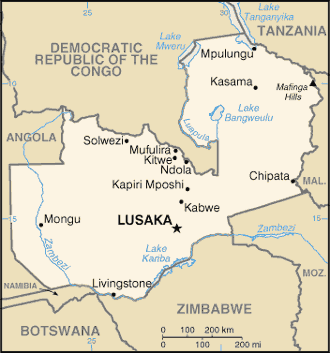 |
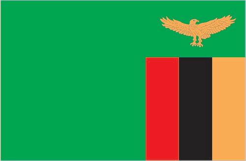
| The national flag of Zambia | Borderline map of Zambia |
| Flag description: green field with a panel of three vertical bands of red (hoist side), black, and orange below a soaring orange eagle, on the outer edge of the flag; green stands for the country’s natural resources and vegetation, red symbolizes the struggle for freedom, black the people of Zambia, and orange the country’s mineral wealth; the eagle represents the people’s ability to rise above the nation’s problems. | Border length: total: 6,043.15 km. Border countries (total: 8): Angola 1,065 km, Botswana 0.15 km, Democratic Republic of the Congo 2,332 km, Malawi 847 km, Mozambique 439 km, Namibia 244 km, Tanzania 353 km, Zimbabwe 763 km. |
Did you know about Zambia?
- Zambia was formerly the British colony of Northern Rhodesia. It granted full independence in 1964.
- Spray from Musi-o-Tunya (Victoria Falls) can be seen up to 20 miles (35 km) away.
- The Zambezi River forms the natural boundary between Zambia and Zimbabwe, dropping a spectacular 420ft (128m) over the magnificent Victoria Falls.
Facts of Zambia (ZM)
Name conventional long form: Republic of Zambia, conventional short form: Zambia, former: Northern Rhodesia, etymology: name derived from the Zambezi River, which flows through the western part of the country and forms its southern border with neighboring Zimbabwe
Codes: ISO; ZM, Internet; .zm
Capital city: Lusaka
Language(s): Bembe 33.4%, Nyanja 14.7%, Tonga 11.4%, Lozi 5.5%, Chewa 4.5%, Nsenga 2.9%, Tumbuka 2.5%, Lunda (North Western) 1.9%, Kaonde 1.8%, Lala 1.8%, Lamba 1.8%, English (official language) 1.7%, Luvale 1.5%, Mambwe 1.3%, Namwanga 1.2%, Lenje 1.1%, Bisa 1%, other 9.7%, unspecified 0.2%. Note: Zambia is said to have over 70 languages, although many of these may be considered dialects; all of Zambia’s major languages are members of the Bantu family (2010 estimate)
National holiday(s): Independence Day, 24 October (1964)
Motto: One Zambia, One Nation
Currency: Zambian kwacha (ZMW)
GPS: 15 00 S, 30 00 E, Lusaka; 15 25 S 28 17 E
Location: Southern Africa, east of Angola, south of the Democratic Republic of the Congo
Geography note: landlocked country; the Zambezi forms a natural riverine boundary with Zimbabwe; Lake Kariba on the Zambia-Zimbabwe border forms the world’s largest reservoir by volume (180 cu km; 43 cu mi)
Land boundaries: Angola 1,065 km, Botswana 0.15 km, Democratic Republic of the Congo 2,332 km, Malawi 847 km, Mozambique 439 km, Namibia 244 km, Tanzania 353 km, Zimbabwe 763 km, total: 6,043.15 km
Maritime boundaries: N/A
Coastline: 0 km (landlocked country)
Area: total: 752,618 sq km; land: 743,398 sq km, water: 9,220 sq km (total 290 585,00 mi2), slightly larger than Texas.
Roadways: total: 40,454 km, paved: 9,403 km, unpaved: 31,051 km (2005)
Waterways: 2,250 km (includes Lake Tanganyika and the Zambezi and Luapula rivers) (2010)
Local time (capital): UTC+2, 7 hours ahead of Washington DC during Standard Time
Note to the local time: N/A
Population in Zambia: 17 609 178
Population in Lusaka: 1 802 000 (including the metropolitan areas)
Urbanization: urban population: 40.9% of total population (2015)
Major urban areas population: LUSAKA (capital) 2.179 million (2015)
Population growth rate: 2.94% (2016 estimate)
Birth rate: 41.8 births / 1,000 population (2016 estimate)
Death rate: 12.4 deaths / 1,000 population (2016 estimate)
Age structure: 0-14 years: 46.08% (male 3,590,466 / female 3,556,756) 15-24 years: 20% (male 1,550,183 / female 1,552,706) 25-54 years: 28.65% (male 2,239,661 / female 2,204,823) 55-64 years: 2.91% (male 211,039 / female 240,156) 65 years and over: 2.35% (male 158,827 / female 206,094) (2016 estimate)
Median age: total: 16.7 years; male: 16.6 years, female: 16.9 years (2016 estimate)
Ethnic groups: Bemba 21%, Tonga 13.6%, Chewa 7.4%, Lozi 5.7%, Nsenga 5.3%, Tumbuka 4.4%, Ngoni 4%, Lala 3.1%, Kaonde 2.9%, Namwanga 2.8%, Lunda (north Western) 2.6%, Mambwe 2.5%, Luvale 2.2%, Lamba 2.1%, Ushi 1.9%, Lenje 1.6%, Bisa 1.6%, Mbunda 1.2%, other 13.8%, unspecified 0.4% (2010 estimate)
Religions: Protestant 75.3%, Roman Catholic 20.2%, other 2.7% (includes Muslim Buddhist, Hindu, and Baha’i), none 1.8% (2010 estimate)
Government type: Unitary Presidential republic
Legal system: mixed legal system of English common law and customary law
National anthem: Stand and Sing of Zambia, Proud and Free
Known national hazards: periodic drought; tropical storms (November to April)
Major infectious diseases: The degree of risk(s): very high food or waterborne diseases: bacterial and protozoal diarrhea, hepatitis A, and typhoid fever vectorborne diseases: malaria and dengue feverwater contact disease: schistosomiasis animal contact disease: rabies (2016)
Land use: agricultural land: 31.7%; arable land 4.8%; permanent crops 0%; permanent pasture 26.9%; forest: 66.3%; other: 2% (2011 estimate)
Agricultural products: corn, sorghum, rice, peanuts, sunflower seeds, vegetables, flowers, tobacco, cotton, sugarcane, cassava (manioc, tapioca), coffee; cattle, goats, pigs, poultry, milk, eggs, hides
Industries: copper mining and processing, emerald mining, construction, foodstuffs, beverages, chemicals, textiles, fertilizer, horticulture
Export commodities: copper/cobalt, cobalt, electricity; tobacco, flowers, cotton
Main export partners: China 25.5%, Democratic Republic of the Congo 13%, South Africa 6.4%, South Korea 4.9%, India 4.3% (2015)
Import commodities: machinery, transportation equipment, petroleum products, electricity, fertilizer, foodstuffs, clothing
Main import partners: South Africa 34.5%, Democratic Republic of the Congo 18.2%, Kenya 9.7%, China 7.3%, India 4.4% (2015)
Navigate the countries in Africa faster and easier while driving, use the interactive Google maps for your driving directions. The continuously updated database contains over 220 countries and territories digitally mapped, hundreds of millions of businesses and places around the world positioned on the map.
Get fresh GPS navigation, traffic, and transit information – no matter what part of Zambia, Lusaka, any other city and country in Africa, or the world you’re in.
Do you like this Zambia information page? Please don’t forget to share it with others! Thank you.
39 thoughts on “Zambia”
Comments are closed.