Namibia Google maps and Driving Directions
Get free driving directions, Google maps, traffic information for Namibia, and Windhoek (GPS: 22 34 S 17 05 E), the capital city of the country located in (the) Southern Africa, bordering the South Atlantic Ocean, between Angola and South Africa.
Find any address in Windhoek on the Google map of Namibia (NA) with ease or calculate your up to date itinerary to and from Namibia or its neighboring counties like Angola, Botswana, South Africa, Zambia.
Sightseeing and exploring in Africa starts here, thanks to Google because its Earth Engine combines a multi-petabyte catalog of updated satellite imagery and geospatial datasets with planetary-scale analysis capabilities. Wonder the world, use the satellite map function of the Google maps to explore or see differences on the Earth’s surface, inland, or the surrounding areas of Namibia.
Google Maps Namibia
Located in southwestern Africa, Namibia gained independence from South Africa in 1990, after 24 years of armed struggle. It regained the territory of Walvis Bay in 1994.
Namibia is mostly high plateau; Namib Desert along coast; Kalahari Desert in east.
The map above fully covers Namibia with its road routes from cities to towns, road intersections in any region, provinces, prefectures, also with free driving directions in Windhoek or to the neighboring towns and countries. To look at the detailed map about a particular quarter in Windhoek, please click on the area and zoom to the place you are interested in the Google maps of Namibia (NA).
Be creative, use the extras of this Google map; This is a detailed, clear, zoomable, large road map of Namibia with its administrative divisions; 14 regions; Erongo, Hardap, //Karas, Kavango East, Kavango West, Khomas, Kunene, Ohangwena, Omaheke, Omusati, Oshana, Oshikoto, Otjozondjupa, Zambezi; note – the Karas Region was renamed //Karas in September 2013 to include the alveolar lateral click of the Khoekhoegowab language.
The interactive map above is also may be used as the satellite map of Namibia, or as a reverse search map for finding an address from its GPS coordinates.
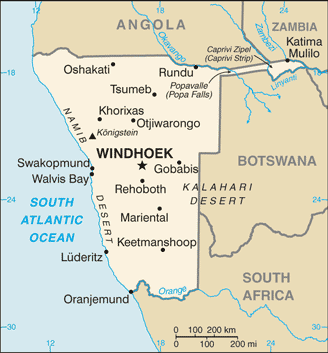
Namibia is bordered on the north by Angola and Zambia, on the east by Botswana, and on the east and south by South Africa. It is for the most part a portion of the high plateau of southern Africa, with a general elevation of from 3,000 to 4,000 ft.
Namibia (area: 824 268 sq km / 318 251,52 sq mi), where the official language is English, lying in Africa and using the currency; Namibian dollar (NAD), since 1993, set their clock to UTC+1. That means they are 6 hours ahead of Washington DC during Standard Time in Windhoek, the capital. Note to the time difference: Daylight saving time: +1hr begins first Sunday in September; ends first Sunday in April.
The climate in Namibia; Almost rainless. The coast is usually shrouded in thick fog, unless the hot, dry berg wind is blowing.
Geography in a nutshell; The Namib Desert stretches along the coastal strip. Inland, a ridge of mountains rises to 8000 ft (2500 m). The Kalahari Desert lies in the east.
Click here for more detailed information about Namibia.
Driving directions Namibia
The Google maps and Google Satellite maps of Namibia above showing the country, located next to Angola, Botswana, South Africa, Zambia. For your further reference, the latitude and longitude coordinates of Namibia are 22 00 S, 17 00 E , while the capital, Windhoek found at 22 34 S 17 05 E.
When you are traveling around Namibia, Windhoek, or its other cities, use this routing tool, providing up to date route planning service free of charge.
Look no further; get accurate driving directions in Namibia, Africa, by filling the route planner form below.
Since Google acquired and introduced its digitalized maps in 2004, you’re probably familiar with its base functions, like finding an address or driving directions to locations. Still, Google maps also accommodate bicyclists, pedestrians, and also public transportation with special directions and customizable routes.
About Namibia and the capital, Windhoek
 |
 |
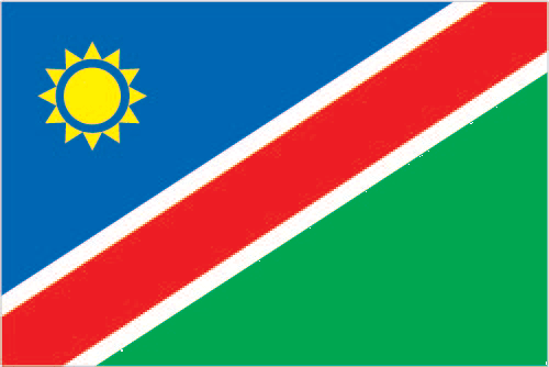
| The national flag of Namibia | Borderline map of Namibia |
| Flag description: a wide red stripe edged by narrow white stripes divides the flag diagonally from lower hoist corner to upper fly corner; the upper hoist-side triangle is blue and charged with a yellow, 12-rayed sunburst; the lower fly-side triangle is green; red signifies the heroism of the people and their determination to build a future of equal opportunity for all; white stands for peace, unity, tranquility, and harmony; blue represents the Namibian sky and the Atlantic Ocean, the country’s precious water resources and rain; the yellow sun denotes power and existence; green symbolizes vegetation and agricultural resources. | Border length: total: 4,220 km. Border countries (total: 4): Angola 1,427 km, Botswana 1,544 km, South Africa 1,005 km, Zambia 244 km. |
Did you know about Namibia?
- Namibia, once German South West Africa, passed into South African control after World War I, until gaining independence in 1990.
- The Namib is the Earths oldest, and one of its driest, deserts.
- Although it is by the sea, the Namib Desert is hot and dry with some of the biggest sand dunes in the world.
Facts of Namibia (NA)
Name conventional long form: Republic of Namibia, conventional short form: Namibia, local long form: Republic of Namibia, local short form: Namibia, former: German South-West Africa (Deutsch Suedwest Afrika), South-West Africa, etymology: named for the coastal Namib Desert; the name “namib” means “vast place” in the Nama/Damara language
Codes: ISO; NA, Internet; .na
Capital city: Windhoek
Language(s): Oshiwambo languages 48.9%, Nama/Damara 11.3%, Afrikaans 10.4% (common language of most of the population and about 60% of the white population), Otjiherero languages 8.6%, Kavango languages 8.5%, Caprivi languages 4.8%, English (official language) 3.4%, other African languages 2.3%, other 1.7%. Note: Namibia has 13 recognized national languages, including 10 indigenous African languages and 3 Indo-European languages (2011 estimate)
National holiday(s): Independence Day, 21 March (1990)
Motto: Unity, Liberty, Justice
Currency: Namibian dollar (NAD), since 1993
GPS: 22 00 S, 17 00 E, Windhoek; 22 34 S 17 05 E
Location: Southern Africa, bordering the South Atlantic Ocean, between Angola and South Africa
Geography note: first country in the world to incorporate the protection of the environment into its constitution; some 14% of the land is protected, including virtually the entire Namib Desert coastal strip
Land boundaries: Angola 1,427 km, Botswana 1,544 km, South Africa 1,005 km, Zambia 244 km, total: 4,220 km
Maritime boundaries: N/A
Coastline: 1,572 km
Area: total: 824,292 sq km; land: 823,290 sq km, water: 1,002 sq km (total 318 251,52 mi2), slightly more than half the size of Alaska.
Roadways: total: 44,138 km, paved: 6,387 km, unpaved: 37,751 km (2010)
Waterways: N/A
Local time (capital): UTC+1, 6 hours ahead of Washington DC during Standard Time
Note to the local time: Daylight saving time: +1hr begins first Sunday in September; ends first Sunday in April
Population in Namibia: 2 587 801
Population in Windhoek: 221 000 (including the metropolitan areas)
Urbanization: urban population: 46.7% of total population (2015)
Major urban areas population: WINDHOEK (capital) 368,000 (2015)
Population growth rate: 1.98% (2016 estimate)
Birth rate: 27.9 births / 1,000 population (2016 estimate)
Death rate: 8.1 deaths / 1,000 population (2016 estimate)
Age structure: 0-14 years: 37.39% (male 460,016 / female 451,058) 15-24 years: 20.35% (male 246,266 / female 249,570) 25-54 years: 34% (male 395,417 / female 432,994) 55-64 years: 4.25% (male 46,769 / female 56,798) 65 years and over: 4.01% (male 41,518 / female 56,063) (2016 estimate)
Median age: total: 21 years; male: 20.2 years, female: 21.7 years (2016 estimate)
Ethnic groups: black 87.5%, white 6%, mixed 6.5%note: about 50% of the population belong to the Ovambo tribe and 9% to the Kavangos tribe; other ethnic groups include Herero 7%, Damara 7%, Nama 5%, Caprivian 4%, Bushmen 3%, Baster 2%, Tswana 0.5%
Religions: Christian 80% to 90% (at least 50% Lutheran), indigenous beliefs 10% to 20%
Government type: Unitary semi-presidential republic
Legal system: mixed legal system of uncodified civil law based on Roman-Dutch law and customary law
National anthem: Namibia, Land of the Brave
Known national hazards: prolonged periods of drought
Major infectious diseases: The degree of risk(s): high food or waterborne diseases: bacterial diarrhea, hepatitis A, and typhoid fever vectorborne disease: malariawater contact disease: schistosomiasis (2016)
Land use: agricultural land: 47.2%; arable land 1%; permanent crops 0%; permanent pasture 46.2%; forest: 8.8%; other: 44% (2011 estimate)
Agricultural products: millet, sorghum, peanuts, grapes; livestock; fish
Industries: meatpacking, fish processing, dairy products, pasta, beverages; mining (diamonds, lead, zinc, tin, silver, tungsten, uranium, copper)
Export commodities: diamonds, copper, gold, zinc, lead, uranium; cattle, white fish and mollusks
Main export partners: N/A
Import commodities: foodstuffs; petroleum products and fuel, machinery and equipment, chemicals
Main import partners: N/A
Navigate the countries in Africa faster and easier while driving, use the interactive Google maps for your driving directions. The continuously updated database contains over 220 countries and territories digitally mapped, hundreds of millions of businesses and places around the world positioned on the map.
Get fresh GPS navigation, traffic, and transit information – no matter what part of Namibia, Windhoek, any other city and country in Africa, or the world you’re in.
Do you like this Namibia information page? Please don’t forget to share it with others! Thank you.