Mozambique Google maps and Driving Directions
Get free driving directions, Google maps, traffic information for Mozambique, and Maputo (GPS: 25 57 S 32 35 E), the capital city of the country located in (the) Southeastern Africa, bordering the Mozambique Channel, between South Africa and Tanzania.
Find any address in Maputo on the Google map of Mozambique (MZ) with ease or calculate your up to date itinerary to and from Mozambique or its neighboring counties like Malawi, South Africa, Swaziland, Tanzania, Zambia, Zimbabwe.
Sightseeing and exploring in Africa starts here, thanks to Google because its Earth Engine combines a multi-petabyte catalog of updated satellite imagery and geospatial datasets with planetary-scale analysis capabilities. Wonder the world, use the satellite map function of the Google maps to explore or see differences on the Earth’s surface, inland, or the surrounding areas of Mozambique.
Google Maps Mozambique
Mozambique lies on the southeast African coast. It was torn apart by a savage and devastating civil war between the Marxist government and a rebel faction between 1977 and 1992.
Mozambique is mostly coastal lowlands, uplands in center, high plateaus in northwest, mountains in west.
The map above fully covers Mozambique with its road routes from cities to towns, road intersections in any region, provinces, prefectures, also with free driving directions in Maputo or to the neighboring towns and countries. To look at the detailed map about a particular quarter in Maputo, please click on the area and zoom to the place you are interested in the Google maps of Mozambique (MZ).
Be creative, use the extras of this Google map; This is a detailed, clear, zoomable, large road map of Mozambique with its administrative divisions; 10 provinces (provincias, singular – provincia), 1 city (cidade)*; Cabo Delgado, Gaza, Inhambane, Manica, Maputo, Cidade de Maputo*, Nampula, Niassa, Sofala, Tete, Zambezia.
The interactive map above is also may be used as the satellite map of Mozambique, or as a reverse search map for finding an address from its GPS coordinates.
Mozambique stretches for 1,535 mi (2,470 km) along Africa’s southeast coast. It is nearly twice the size of California. Tanzania is to the north Malawi, Zambia, and Zimbabwe to the west and South Africa and Swaziland to the south. The country is generally a low-lying plateau broken up by 25 sizable rivers that flow into the Indian Ocean. The largest is the Zambezi, which provides access to central Africa.
Mozambique (area: 801 590 sq km / 309 495,50 sq mi), where the official language is Portuguese, lying in Africa and using the currency; Mozambican metical (MZN), since 1980, set their clock to UTC+2. That means they are 7 hours ahead of Washington DC during Standard Time in Maputo, the capital. Note to the time difference: N/A.
The climate in Mozambique; Tropical. Temperatures are hottest on the coast. Extremes of rainfall: drought and flood.
Geography in a nutshell; Largely a savanna-covered plateau. The coast is fringed by coral reefs and lagoons. The Zambezi River bisects the country.
Click here for more detailed information about Mozambique.
Driving directions Mozambique
The Google maps and Google Satellite maps of Mozambique above showing the country, located next to Malawi, South Africa, Swaziland, Tanzania, Zambia, Zimbabwe. For your further reference, the latitude and longitude coordinates of Mozambique are 18 15 S, 35 00 E , while the capital, Maputo found at 25 57 S 32 35 E.
When you are traveling around Mozambique, Maputo, or its other cities, use this routing tool, providing up to date route planning service free of charge.
Look no further; get accurate driving directions in Mozambique, Africa, by filling the route planner form below.
Since Google acquired and introduced its digitalized maps in 2004, you’re probably familiar with its base functions, like finding an address or driving directions to locations. Still, Google maps also accommodate bicyclists, pedestrians, and also public transportation with special directions and customizable routes.
About Mozambique and the capital, Maputo
 |
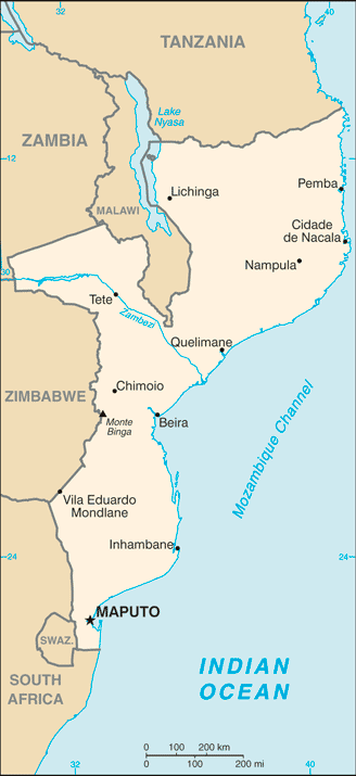 |
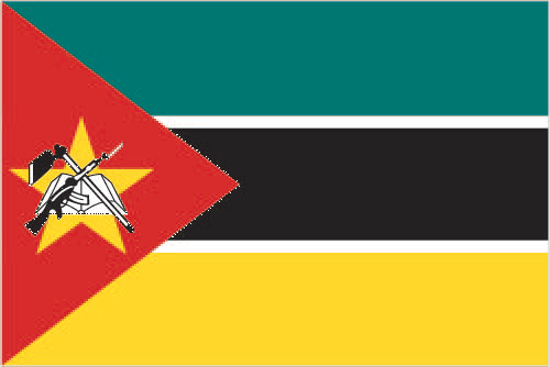
| The national flag of Mozambique | Borderline map of Mozambique |
| Flag description: three equal horizontal bands of green (top), black, and yellow with a red isosceles triangle based on the hoist side; the black band is edged in white; centered in the triangle is a yellow five-pointed star bearing a crossed rifle and hoe in black superimposed on an open white book; green represents the riches of the land, white peace, black the African continent, yellow the country’s minerals, and red the struggle for independence; the rifle symbolizes defense and vigilance, the hoe refers to the country’s agriculture, the open book stresses the importance of education, and the star represents Marxism and internationalism. | Border length: total: 4,783 km. Border countries (total: 6): Malawi 1,498 km, South Africa 496 km, Swaziland 108 km, Tanzania 840 km, Zambia 439 km, Zimbabwe 1,402 km. |
Did you know about Mozambique?
- Mozambique was a Portuguese colony before becoming independent under the single-party rule of Frelimo in 1975.
- Maputos busy port serves Zimbabwe and South Africa.
- Mozambique has some of the best unspoiled beaches in Africa, as well as many national parks.
Facts of Mozambique (MZ)
Name conventional long form: Republic of Mozambique, conventional short form: Mozambique, local long form: Republica de Mocambique, local short form: Mocambique, former: Portuguese East Africa, etymology: named for the offshore island of Mozambique; the island was apparently named after Mussa al-BIK, an influential Arab slave trader who set himself up as sultan on the island in the 15th century
Codes: ISO; MZ, Internet; .mz
Capital city: Maputo
Language(s): Emakhuwa 25.3%, Portuguese (official language) 10.7%, Xichangana 10.3%, Cisena 7.5%, Elomwe 7%, Echuwabo 5.1%, other Mozambican languages 30.1%, other 4% (1997 census)
National holiday(s): Independence Day, 25 June (1975)
Motto: N/A
Currency: Mozambican metical (MZN), since 1980
GPS: 18 15 S, 35 00 E, Maputo; 25 57 S 32 35 E
Location: Southeastern Africa, bordering the Mozambique Channel, between South Africa and Tanzania
Geography note: the Zambezi River flows through the north-central and most fertile part of the country
Land boundaries: Malawi 1,498 km, South Africa 496 km, Swaziland 108 km, Tanzania 840 km, Zambia 439 km, Zimbabwe 1,402 km, total: 4,783 km
Maritime boundaries: Indian Ocean
Coastline: 2,470 km
Area: total: 799,380 sq km; land: 786,380 sq km, water: 13,000 sq km (total 309 495,50 mi2), slightly less than twice the size of California.
Roadways: total: 30,331 km, paved: 6,303 km, unpaved: 24,028 km (2009)
Waterways: 460 km (Zambezi River navigable to Tete and along Cahora Bassa Lake) (2010)
Local time (capital): UTC+2, 7 hours ahead of Washington DC during Standard Time
Note to the local time: N/A
Population in Mozambique: 30 528 673
Population in Maputo: 1 691 000 (including the metropolitan areas)
Urbanization: urban population: 32.2% of total population (2015)
Major urban areas population: MAPUTO (capital) 1.187 million; Matola 937,000 (2015)
Population growth rate: 2.45% (2016 estimate)
Birth rate: 38.3 births / 1,000 population (2016 estimate)
Death rate: 11.9 deaths / 1,000 population (2016 estimate)
Age structure: 0-14 years: 44.92% (male 5,856,623 / female 5,791,519) 15-24 years: 21.51% (male 2,741,474 / female 2,835,474) 25-54 years: 27.24% (male 3,301,883 / female 3,762,626) 55-64 years: 3.42% (male 425,312 / female 462,125) 65 years and over: 2.9% (male 345,408 / female 407,706) (2016 estimate)
Median age: total: 17.1 years; male: 16.5 years, female: 17.7 years (2016 estimate)
Ethnic groups: African 99.66% (Makhuwa, Tsonga, Lomwe, Sena, and others), Europeans 0.06%, Euro-Africans 0.2%, Indians 0.08%
Religions: Roman Catholic 28.4%, Muslim 17.9%, Zionist Christian 15.5%, Protestant 12.2% (includes Pentecostal 10.9% and Anglican 1.3%), other 6.7%, none 18.7%, unspecified 0.7% (2007 estimate)
Government type: Unitary semi-presidential republic
Legal system: mixed legal system of Portuguese civil law, and customary law; note – in rural, predominately Muslim villages with no formal legal system, Islamic law may be applied
National anthem: Pátria Amada (Beloved Homeland)
Known national hazards: severe droughts; devastating cyclones and floods in central and southern provinces
Major infectious diseases: The degree of risk(s): very high food or waterborne diseases: bacterial and protozoal diarrhea, hepatitis A, and typhoid fever vectorborne diseases: malaria and dengue feverwater contact disease: schistosomiasis animal contact disease: rabies (2016)
Land use: agricultural land: 56.3%; arable land 6.4%; permanent crops 0.3%; permanent pasture 49.6%; forest: 43.7%; other: 0% (2011 estimate)
Agricultural products: cotton, cashew nuts, sugarcane, tea, cassava (manioc, tapioca), corn, coconuts, sisal, citrus and tropical fruits, potatoes, sunflowers; beef, poultry
Industries: aluminum, petroleum products, chemicals (fertilizer, soap, paints), textiles, cement, glass, asbestos, tobacco, food, beverages
Export commodities: aluminum, prawns, cashews, cotton, sugar, citrus, timber; bulk electricity
Main export partners: South Africa 24.9%, China 10.2%, Italy 8.9%, India 8.9%, Belgium 7.9%, Spain 4.4% (2015)
Import commodities: machinery and equipment, vehicles, fuel, chemicals, metal products, foodstuffs, textiles
Main import partners: South Africa 26.8%, China 19.3%, India 13.9% (2015)
Navigate the countries in Africa faster and easier while driving, use the interactive Google maps for your driving directions. The continuously updated database contains over 220 countries and territories digitally mapped, hundreds of millions of businesses and places around the world positioned on the map.
Get fresh GPS navigation, traffic, and transit information – no matter what part of Mozambique, Maputo, any other city and country in Africa, or the world you’re in.
Do you like this Mozambique information page? Please don’t forget to share it with others! Thank you.