South Africa Google maps and Driving Directions
Get free driving directions, Google maps, traffic information for South Africa, and Pretoria (GPS: 25 42 S28 13 E), the capital city of the country located in (the) Southern Africa, at the southern tip of the continent of Africa.
Find any address in Pretoria on the Google map of South Africa (ZA) with ease or calculate your up to date itinerary to and from South Africa or its neighboring counties like Botswana, Lesotho, Mozambique, Namibia, Swaziland, Zimbabwe.
Sightseeing and exploring in Africa starts here, thanks to Google because its Earth Engine combines a multi-petabyte catalog of updated satellite imagery and geospatial datasets with planetary-scale analysis capabilities. Wonder the world, use the satellite map function of the Google maps to explore or see differences on the Earth’s surface, inland, or the surrounding areas of South Africa.
Google Maps South Africa
After 80 years of white minority rule, South Africa held its first multiracial, multiparty elections in 1994. Victory for the blacks marked the symbolic overturning of long years of apartheid.
South Africa is vast interior plateau rimmed by rugged hills and narrow coastal plain.
The map above fully covers South Africa with its road routes from cities to towns, road intersections in any region, provinces, prefectures, also with free driving directions in Pretoria or to the neighboring towns and countries. To look at the detailed map about a particular quarter in Pretoria, please click on the area and zoom to the place you are interested in the Google maps of South Africa (ZA).
Be creative, use the extras of this Google map; This is a detailed, clear, zoomable, large road map of South Africa with its administrative divisions; 9 provinces; Eastern Cape, Free State, Gauteng, KwaZulu-Natal, Limpopo, Mpumalanga, Northern Cape, North West, Western Cape.
The interactive map above is also may be used as the satellite map of South Africa, or as a reverse search map for finding an address from its GPS coordinates.
South Africa, on the continent’s southern tip, is bordered by the Atlantic Ocean on the west and by the Indian Ocean on the south and east. Its neighbors are Namibia in the northwest, Zimbabwe and Botswana in the north, and Mozambique and Swaziland in the northeast. The kingdom of Lesotho forms an enclave within the southeast part of South Africa, which occupies an area nearly three times that of California. The southernmost point of Africa is Cape Agulhas, located in the Western Cape Province about 100 mi (161 km) southeast of the Cape of Good Hope.
South Africa (area: 1 221 040 sq km / 471 445,99 sq mi), where the official language is Afrikaans, English, Northern Sotho, Sotho, Southern Ndebele, Swazi, Tsonga, Tswana, Venda, Xhosa, Zulu, lying in Africa and using the currency; South African rand (ZAR), since 1961, set their clock to UTC+2. That means they are 7 hours ahead of Washington DC during Standard Time in Pretoria, the capital. Note to the time difference: N/A.
The climate in South Africa; Warm, temperate, and dry. Cape Town has a Mediterranean climate. Semiarid in the west.
Geography in a nutshell; Much of the interior is grassy veld. Desert in the west and far north. Mountains east, south, and west.
Click here for more detailed information about South Africa.
Driving directions South Africa
The Google maps and Google Satellite maps of South Africa above showing the country, located next to Botswana, Lesotho, Mozambique, Namibia, Swaziland, Zimbabwe. For your further reference, the latitude and longitude coordinates of South Africa are 29 00 S, 24 00 E , while the capital, Pretoria found at 25 42 S28 13 E.
When you are traveling around South Africa, Pretoria, or its other cities, use this routing tool, providing up to date route planning service free of charge.
Look no further; get accurate driving directions in South Africa, Africa, by filling the route planner form below.
Since Google acquired and introduced its digitalized maps in 2004, you’re probably familiar with its base functions, like finding an address or driving directions to locations. Still, Google maps also accommodate bicyclists, pedestrians, and also public transportation with special directions and customizable routes.
About South Africa and the capital, Pretoria
 |
 |
| The national flag of South Africa | Borderline map of South Africa |
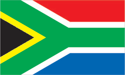
| Flag description: two equal width horizontal bands of red (top) and blue separated by a central green band that splits into a horizontal Y, the arms of which end at the corners of the hoist side; the Y embraces a black isosceles triangle from which the arms are separated by narrow yellow bands; the red and blue bands are separated from the green band and its arms by narrow white stripes; the flag colors do not have any official symbolism, but the Y stands for the “convergence of diverse elements within South African society, taking the road ahead in unity”; black, yellow, and green are found on the flag of the African National Congress, while red, white, and blue are the colors in the flags of the Netherlands and the UK, whose settlers ruled South Africa during the colonial era. Note: the South African flag is one of only two national flags to display six colors as part of its primary design, the other is South Sudan‘s. | Border length: total: 5,244 km. Border countries (total: 6): Botswana 1,969 km, Lesotho 1,106 km, Mozambique 496 km, Namibia 1,005 km, Swaziland 438 km, Zimbabwe 230 km. |
Did you know about South Africa?
- The Union of South Africa formed in 1910 and the republic in 1961. In 1994 a democratic, multi-racial constitution adopted.
- Over the last century, South Africa has produced over half of the worlds gold.
- The massive Kruger National Park has more than 130 different species of mammal, including the “big five: lions, African buffalo, leopards, rhinoceroses, and elephants.
Facts of South Africa (ZA)
Name conventional long form: Republic of South Africa, conventional short form: South Africa, former: Union of South Africaabbreviation: RSA, etymology: self-descriptive name from the country’s location on the continent; “Africa” is derived from the Roman designation of the area corresponding to present-day Tunisia “Africa terra,” which meant “Land of the Afri” (the tribe resident in that area), but which eventually came to mean the entire continent
Codes: ISO; ZA, Internet; .za
Capital city: Pretoria
Language(s): IsiZulu (official language) 22.7%, IsiXhosa (official language) 16%, Afrikaans (official language) 13.5%, English (official language) 9.6%, Sepedi (official language) 9.1%, Setswana (official language) 8%, Sesotho (official language) 7.6%, Xitsonga (official language) 4.5%, siSwati (official language) 2.5%, Tshivenda (official language) 2.4%, isiNdebele (official language) 2.1%, sign language 0.5%, other 1.6% (2011 estimate)
National holiday(s): Freedom Day, 27 April (1994)
Motto: Unity in Diversity
Currency: South African rand (ZAR), since 1961
GPS: 29 00 S, 24 00 E, Pretoria; 25 42 S28 13 E
Location: Southern Africa, at the southern tip of the continent of Africa
Geography note: South Africa completely surrounds Lesotho and almost completely surrounds Swaziland
Land boundaries: Botswana 1,969 km, Lesotho 1,106 km, Mozambique 496 km, Namibia 1,005 km, Swaziland 438 km, Zimbabwe 230 km, total: 5,244 km
Maritime boundaries: N/A
Coastline: 2,798 km
Area: total: 1,219,090 sq km; land: 1,214,470 sq km, water: 4,620 sq km (total 471 445,99 mi2), slightly less than twice the size of Texas.
Roadways: total: 747,014 km, paved: 158,952 km, unpaved: 588,062 km (2014)
Waterways: N/A
Local time (capital): UTC+2, 7 hours ahead of Washington DC during Standard Time
Note to the local time: N/A
Population in South Africa: 57 398 421
Population in Pretoria: 1 501 000 (including the metropolitan areas)
Urbanization: urban population: 64.8% of total population (2015)
Major urban areas population: Johannesburg (includes Ekurhuleni) 9.399 million; Cape Town (legislative capital) 3.66 million; Durban 2.901 million; PRETORIA (capital) 2.059 million; Port Elizabeth 1.179 million; Vereeniging 1.155 million (2015)
Population growth rate: 0.99% (2016 estimate)
Birth rate: 20.5 births / 1,000 population (2016 estimate)
Death rate: 9.6 deaths / 1,000 population (2016 estimate)
Age structure: 0-14 years: 28.34% (male 7,718,511 / female 7,667,830) 15-24 years: 18.07% (male 4,865,807 / female 4,943,707) 25-54 years: 41.44% (male 11,372,944 / female 11,130,874) 55-64 years: 6.59% (male 1,662,874 / female 1,915,908) 65 years and over: 5.57% (male 1,269,551 / female 1,752,698) (2016 estimate)
Median age: total: 26.8 years; male: 26.5 years, female: 27 years (2016 estimate)
Ethnic groups: black African 80.2%, white 8.4%, colored 8.8%, Indian/Asian 2.5%note: colored is a term used in South Africa, including on the national census, for persons of mixed race ancestry (2014 estimate)
Religions: Protestant 36.6% (Zionist Christian 11.1%, Pentecostal/Charismatic 8.2%, Methodist 6.8%, Dutch Reformed 6.7%, Anglican 3.8%), Catholic 7.1%, Muslim 1.5%, other Christian 36%, other 2.3%, unspecified 1.4%, none 15.1% (2001 census)
Government type: Unitary parliamentary constitutional republic
Legal system: mixed legal system of Roman-Dutch civil law, English common law, and customary law
National anthem: National anthem of South Africa – combination of ‘Nkosi Sikelel’ iAfrika’ (God Bless Africa) and ‘Die Stem van Suid-Afrika’ (The Call of South Africa)
Known national hazards: prolonged droughtsvolcanism: the volcano forming Marion Island in the Prince Edward Islands, which last erupted in 2004, is South Africa’s only active volcano
Major infectious diseases: The degree of risk(s): intermediatefood or waterborne diseases: bacterial diarrhea, hepatitis A, and typhoid feverwater contact disease: schistosomiasis (2016)
Land use: agricultural land: 79.4%; arable land 9.9%; permanent crops 0.3%; permanent pasture 69.2%; forest: 7.6%; other: 13% (2011 estimate)
Agricultural products: corn, wheat, sugarcane, fruits, vegetables; beef, poultry, mutton, wool, dairy products
Industries: mining (world’s largest producer of platinum, gold, chromium), automobile assembly, metalworking, machinery, textiles, iron and steel, chemicals, fertilizer, foodstuffs, commercial ship repair
Export commodities: gold, diamonds, platinum, other metals and minerals, machinery and equipment
Main export partners: China 11.3%, US 7.3%, Germany 6%, Namibia 5.2%, Botswana 5.2%, Japan 4.7%, UK 4.3%, India 4.2% (2015)
Import commodities: machinery and equipment, chemicals, petroleum products, scientific instruments, foodstuffs
Main import partners: China 17.6%, Germany 11.2%, US 6.7%, Nigeria 5%, India 4.7%, Saudi Arabia 4.1% (2015)
Navigate the countries in Africa faster and easier while driving, use the interactive Google maps for your driving directions. The continuously updated database contains over 220 countries and territories digitally mapped, hundreds of millions of businesses and places around the world positioned on the map.
Get fresh GPS navigation, traffic, and transit information – no matter what part of South Africa, Pretoria, any other city and country in Africa, or the world you’re in.
Do you like this South Africa information page? Please don’t forget to share it with others! Thank you.