Tanzania Google maps and Driving Directions
Get free driving directions, Google maps, traffic information for Tanzania, and Dar es Salaam (GPS: 6 48 S 39 17 E), the capital city of the country located in (the) Eastern Africa, bordering the Indian Ocean, between Kenya and Mozambique.
Find any address in Dar es Salaam on the Google map of Tanzania (TZ) with ease or calculate your up to date itinerary to and from Tanzania or its neighboring counties like Burundi, Democratic Republic of Congo, Kenya, Malawi, Mozambique, Rwanda, Uganda, Zambia.
Sightseeing and exploring in Africa starts here, thanks to Google because its Earth Engine combines a multi-petabyte catalog of updated satellite imagery and geospatial datasets with planetary-scale analysis capabilities. Wonder the world, use the satellite map function of the Google maps to explore or see differences on the Earth’s surface, inland, or the surrounding areas of Tanzania.
Google Maps Tanzania
The east African state of Tanzania was formed in 1964 by the union of Tanganyika and the Zanzibar islands. A third of its area is game reserve or national park.
Tanzania is plains along coast; central plateau; highlands in north, south.
The map above fully covers Tanzania with its road routes from cities to towns, road intersections in any region, provinces, prefectures, also with free driving directions in Dar es Salaam or to the neighboring towns and countries. To look at the detailed map about a particular quarter in Dodoma, please click on the area and zoom to the place you are interested in the Google maps of Tanzania (TZ).
Be creative, use the extras of this Google map; This is a detailed, clear, zoomable, large road map of Tanzania with its administrative divisions; 30 regions; Arusha, Dar es Salaam, Dodoma, Geita, Iringa, Kagera, Kaskazini Pemba (Pemba North), Kaskazini Unguja (Zanzibar North), Katavi, Kigoma, Kilimanjaro, Kusini Pemba (Pemba South), Kusini Unguja (Zanzibar Central/South), Lindi, Manyara, Mara, Mbeya, Mjini Magharibi (Zanzibar Urban/West), Morogoro, Mtwara, Mwanza, Njombe, Pwani (Coast), Rukwa, Ruvuma, Shinyanga, Simiyu, Singida, Tabora, Tanga.
The interactive map above is also may be used as the satellite map of Tanzania, or as a reverse search map for finding an address from its GPS coordinates.
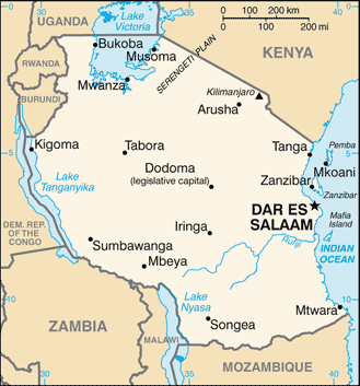
Tanzania is in East Africa on the Indian Ocean. To the north are Uganda and Kenya to the west, Burundi, Rwanda, and Congo and to the south, Mozambique, Zambia, and Malawi. Its area is three times that of New Mexico. Tanzania contains three of Africa’s best-known lakes – Victoria in the north, Tanganyika in the west, and Nyasa in the south. Mount Kilimanjaro in the north, 19,340 ft (5,895 m), is the highest point on the continent. The island of Zanzibar is separated from the mainland by a 22-mile channel.
Tanzania (area: 945 087 sq km / 364 899,98 sq mi), where the official language is Swahili, lying in Africa and using the currency; Tanzanian shilling (TZS), since 1966, set their clock to UTC+3. That means they are 8 hours ahead of Washington DC during Standard Time in Dodoma, the capital. Note to the time difference: N/A.
The climate in Tanzania; Tropical on the coast and Zanzibar. Semiarid on central plateau, semitemperate in the highlands. MarchMay rains.
Geography in a nutshell; The mainland is mostly a high plateau lying to the east of the Great Rift Valley. Forested coastal plain. Highlands in the north and south.
Click here for more detailed information about Tanzania.
Driving directions Tanzania
The Google maps and Google Satellite maps of Tanzania above showing the country, located next to Burundi, Democratic Republic of Congo, Kenya, Malawi, Mozambique, Rwanda, Uganda, Zambia. For your further reference, the latitude and longitude coordinates of Tanzania are 6 00 S, 35 00 E , while the capital, Dodoma found at 6 48 S 39 17 E.
When you are traveling around Tanzania, Dodoma, or its other cities, use this routing tool, providing up to date route planning service free of charge.
Look no further; get accurate driving directions in Tanzania, Africa, by filling the route planner form below.
Since Google acquired and introduced its digitalized maps in 2004, you’re probably familiar with its base functions, like finding an address or driving directions to locations. Still, Google maps also accommodate bicyclists, pedestrians, and also public transportation with special directions and customizable routes.
About Tanzania and the capital, Dar es Salaam
 |
 |
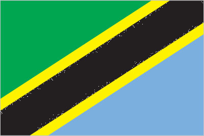
| The national flag of Tanzania | Borderline map of Tanzania |
| Flag description: divided diagonally by a yellow-edged black band from the lower hoist-side corner; the upper triangle (hoist side) is green and the lower triangle is blue; the banner combines colors found on the flags of Tanganyika and Zanzibar; green represents the natural vegetation of the country, gold its rich mineral deposits, black the native Swahili people, and blue the country’s many lakes and rivers, as well as the Indian Ocean. | Border length: total: 4,161 km. Border countries (total: 8): Burundi 589 km, Democratic Republic of the Congo 479 km, Kenya 775 km, Malawi 512 km, Mozambique 840 km, Rwanda 222 km, Uganda 391 km, Zambia 353 km. |
Did you know about Tanzania?
- The British Trusteeship Territory of Tanganyika became independent in 1961. In 1964, it merged with the Republic of Zanzibar, to form Tanzania.
- At 19,340 ft (5895 m), Kilimanjaro in northeast Tanzaniais Africas highest mountain.
- Fossilized remains of the earliest humans were found in Tanzanias Olduvai Gorge-proof that the first humans lived in Africa.
Facts of Tanzania (TZ)
Name conventional long form: United Republic of Tanzania, conventional short form: Tanzania, local long form: Jamhuri ya Muungano wa Tanzania, local short form: Tanzania, former: United Republic of Tanganyika and Zanzibar. Note: the country’s name is a combination of the first letters of Tanganyika and Zanzibar, the two states that merged to form Tanzania in 1964
Codes: ISO; TZ, Internet; .tz
Capital city: Dar es Salaam
Language(s): Kiswahili or Swahili (official language), Kiunguja (name for Swahili in Zanzibar), English (official language, primary language of commerce, administration, and higher education), Arabic (widely spoken in Zanzibar), many local languages. Note: Kiswahili (Swahili) is the mother tongue of the Bantu people living in Zanzibar and nearby coastal Tanzania; although Kiswahili is Bantu in structure and origin, its vocabulary draws on a variety of sources including Arabic and English; it has become the lingua franca of central and eastern Africa; the first language of most people is one of the local languages
National holiday(s): Union Day (Tanganyika and Zanzibar), 26 April (1964)
Motto: Uhuru na Umoja (Freedom and Unity)
Currency: Tanzanian shilling (TZS), since 1966
GPS: 6 00 S, 35 00 E, Dar es Salaam; 6 48 S 39 17 E
Location: Eastern Africa, bordering the Indian Ocean, between Kenya and Mozambique
Geography note: Kilimanjaro is the highest point in Africa and one of only two mountains on the continent that has glaciers (the other is Mount Kenya); bordered by three of the largest lakes on the continent: Lake Victoria (the world’s second-largest freshwater lake) in the north, Lake Tanganyika (the world’s second deepest) in the west, and Lake Nyasa (Lake Malawi) in the southwest
Land boundaries: Burundi 589 km, Democratic Republic of the Congo 479 km, Kenya 775 km, Malawi 512 km, Mozambique 840 km, Rwanda 222 km, Uganda 391 km, Zambia 353 km, total: 4,161 km
Maritime boundaries: N/A
Coastline: 1,424 km
Area: total: 947,300 sq km; land: 885,800 sq km, water: 61,500 sq km (total 364 899,98 mi2), more than six times the size of Georgia; slightly larger than twice the size of California.
Roadways: total: 86,472 km, paved: 7,092 km, unpaved: 79,380 km (2010)
Waterways: (Lake Tanganyika, Lake Victoria, and Lake Nyasa (Lake Malawi) are the principal avenues of commerce with neighboring countries; the rivers are not navigable) (2011)
Local time (capital): UTC+3, 8 hours ahead of Washington DC during Standard Time
Note to the local time: N/A
Population in Tanzania: 59 091 392
Population in Dodoma: 3 588 000 (including the metropolitan areas)
Urbanization: urban population: 31.6% of total population (2015)
Major urban areas population: DAR ES SALAAM (capital) 5.116 million; Mwanza 838,000 (2015)
Population growth rate: 2.77% (2016 estimate)
Birth rate: 36 births / 1,000 population (2016 estimate)
Death rate: 7.8 deaths / 1,000 population (2016 estimate)
Age structure: 0-14 years: 44.06% (male 11,678,349 / female 11,444,708) 15-24 years: 19.71% (male 5,173,239 / female 5,169,214) 25-54 years: 29.74% (male 7,840,941 / female 7,767,797) 55-64 years: 3.5% (male 802,760 / female 1,034,151) 65 years and over: 2.99% (male 668,102 / female 903,465) (2016 estimate)
Median age: total: 17.6 years; male: 17.3 years, female: 17.9 years (2016 estimate)
Ethnic groups: mainland – African 99% (of which 95% are Bantu consisting of more than 130 tribes), other 1% (consisting of Asian, European, and Arab); Zanzibar – Arab, African, mixed Arab and African
Religions: Christian 61.4%, Muslim 35.2%, folk religion 1.8%, other 0.2%, unaffiliated 1.4%note: Zanzibar is almost entirely Muslim (2010 estimate)
Government type: Unitary presidential socialist republic
Legal system: English common law; judicial review of legislative acts limited to matters of interpretation
National anthem: Mungu ibariki Afrika (God Bless Africa)
Known national hazards: flooding on the central plateau during the rainy season; droughtvolcanism: limited volcanic activity; Ol Doinyo Lengai (elev. 2,962 m) has emitted lava in recent years; other historically active volcanoes include Kieyo and Meru
Major infectious diseases: The degree of risk(s): very high food or waterborne diseases: bacterial diarrhea, hepatitis A, and typhoid fever vectorborne diseases: malaria, dengue fever, and Rift Valley feverwater contact diseases: schistosomiasis and leptospirosisanimal contact disease: rabies (2016)
Land use: agricultural land: 43.7%; arable land 14.3%; permanent crops 2.3%; permanent pasture 27.1%; forest: 37.3%; other: 19% (2011 estimate)
Agricultural products: coffee, sisal, tea, cotton, pyrethrum (insecticide made from chrysanthemums), cashew nuts, tobacco, cloves, corn, wheat, cassava (manioc, tapioca), bananas, fruits, vegetables; cattle, sheep, goats
Industries: agricultural processing (sugar, beer, cigarettes, sisal twine); mining (diamonds, gold, and iron), salt, soda ash; cement, oil refining, shoes, apparel, wood products, fertilizer
Export commodities: gold, coffee, cashew nuts, manufactures, cotton
Main export partners: India 21.4%, China 8.1%, Japan 5.1%, Kenya 4.6%, Belgium 4.3% (2015)
Import commodities: consumer goods, machinery and transportation equipment, industrial raw materials, crude oil
Main import partners: China 34.6%, India 13.5%, South Africa 4.7%, UAE 4.4%, Kenya 4.1% (2015)
Navigate the countries in Africa faster and easier while driving, use the interactive Google maps for your driving directions. The continuously updated database contains over 220 countries and territories digitally mapped, hundreds of millions of businesses and places around the world positioned on the map.
Get fresh GPS navigation, traffic, and transit information – no matter what part of Tanzania, Dar es Salaam, any other city and country in Africa, or the world you’re in.
Do you like this Tanzania information page? Please don’t forget to share it with others! Thank you.