Yemen Google maps and Driving Directions
Get free driving directions, Google maps, traffic information for Yemen, and Sana’a (GPS: 15 21 N 44 12 E), the capital city of the country located in (the) Middle East, bordering the Arabian Sea, Gulf of Aden, and Red Sea, between Oman and Saudi Arabia.
Find any address in Sana’a on the Google map of Yemen (YE) with ease or calculate your up to date itinerary to and from Yemen or its neighboring counties like Oman, Saudi Arabia.
Sightseeing and exploring in Asia starts here, thanks to Google because its Earth Engine combines a multi-petabyte catalog of updated satellite imagery and geospatial datasets with planetary-scale analysis capabilities. Wonder the world, use the satellite map function of the Google maps to explore or see differences on the Earth’s surface, inland, or the surrounding areas of Yemen.
Google Maps Yemen
Located in southern Arabia, Yemen was formerly two countries: the Peoples Democratic Republic of Yemen (south and east) and the Yemen Arab Republic (northwest) were united in 1990.
Yemen is narrow coastal plain backed by flat-topped hills and rugged mountains; dissected upland desert plains in center slope into the desert interior of the Arabian Peninsula.
The map above fully covers Yemen with its road routes from cities to towns, road intersections in any region, provinces, prefectures, also with free driving directions in Sana’a or to the neighboring towns and countries. To look at the detailed map about a particular quarter in Sanaa, please click on the area and zoom to the place you are interested in the Google maps of Yemen (YE).
Be creative, use the extras of this Google map; This is a detailed, clear, zoomable, large road map of Yemen with its administrative divisions; 22 governorates (muhafazat, singular – muhafazah); Abyan, ‘Adan (Aden), Ad Dali’, Al Bayda’, Al Hudaydah, Al Jawf, Al Mahrah, Al Mahwit, Amanat al ‘Asimah (Sanaa City), ‘Amran, Arkhabil Suqutra (Socotra Archipelago), Dhamar, Hadramawt, Hajjah, Ibb, Lahij, Ma’rib, Raymah, Sa’dah, San’a’ (Sanaa), Shabwah, Ta’izz.
The interactive map above is also may be used as the satellite map of Yemen, or as a reverse search map for finding an address from its GPS coordinates.
Formerly divided into two nations, the People’s Democratic Republic of Yemen and the Yemen Arab Republic, the Republic of Yemen occupies the southwest tip of the Arabian Peninsula on the Red Sea opposite Ethiopia and extends along the southern part of the Arabian Peninsula on the Gulf of Aden and the Indian Ocean. Saudi Arabia is to the north and Oman is to the east. The country is about the size of France. A 700-mile (1,130-km) narrow coastal plain in the south gives way to a mountainous region and then a plateau area.
Yemen (area: 527 968 sq km / 203 849,50 sq mi), where the official language is Arabic, lying in Asia and using the currency; Yemeni rial (YER), since 1990, set their clock to UTC+3. That means they are 8 hours ahead of Washington DC during Standard Time in Sanaa, the capital. Note to the time difference: N/A.
The climate in Yemen; Desert climate, modified by altitude, which affects temperatures by as much as 54°F (30°C).
Geography in a nutshell; Mountainous west with a fertile strip along the Red Sea. Arid desert and mountains elsewhere.
Click here for more detailed information about Yemen.
Driving directions Yemen
The Google maps and Google Satellite maps of Yemen above showing the country, located next to Oman, Saudi Arabia. For your further reference, the latitude and longitude coordinates of Yemen are 15 00 N, 48 00 E , while the capital, Sanaa found at 15 21 N 44 12 E.
When you are traveling around Yemen, Sanaa, or its other cities, use this routing tool, providing up to date route planning service free of charge.
Look no further; get accurate driving directions in Yemen, Middle East, by filling the route planner form below.
[xyz-ihs snippet=”routing”]
Since Google acquired and introduced its digitalized maps in 2004, you’re probably familiar with its base functions, like finding an address or driving directions to locations. Still, Google maps also accommodate bicyclists, pedestrians, and also public transportation with special directions and customizable routes.
About Yemen and the capital, Sana’a
 |
 |
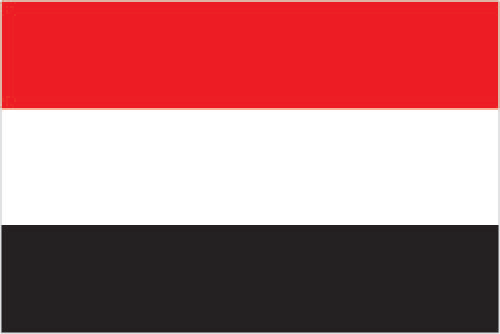
| The national flag of Yemen | Borderline map of Yemen |
| Flag description: three equal horizontal bands of red (top), white, and black; the band colors derive from the Arab Liberation flag and represent oppression (black), overcome through bloody struggle (red), to be replaced by a bright future (white). Note: similar to the flag of Syria, which has two green stars in the white band, and of Iraq, which has an Arabic inscription centered in the white band; also similar to the flag of Egypt, which has a heraldic eagle centered in the white band. | Border length: total: 1,601 km. Border countries (total: 2): Oman 294 km, Saudi Arabia 1,307 km. |
Did you know about Yemen?
- Yemen was originally two countries, the Kingdom of Yemen, in the north, and the British Aden Protectorate in the south. The two united in 1990.
- Mokha, on the Red Sea, gave its name to the first coffee beans exported to Europe in the 1600s.
- It is thought that drinking coffee originated in Yemen, which still produces some of the worlds finest coffee beans today.
Facts of Yemen (YE)
Name conventional long form: Republic of Yemen, conventional short form: Yemen, local long form: Al Jumhuriyah al Yamaniyah, local short form: Al Yaman, former: Yemen Arab Republic [Yemen (Sanaa) or North Yemen] and People’s Democratic Republic of Yemen [Yemen (Aden) or South Yemen], etymology: name derivation remains unclear but may come from the Arab term “yumn” (happiness) and be related to the region’s classical name “Arabia Felix” (Fertile or Happy Arabia); the Romans referred to the rest of the peninsula as “Arabia Deserta” (Deserted Arabia)
Codes: ISO; YE, Internet; .ye
Capital city: Sana’a
Language(s): Arabic (official language). Note: a distinct Socotri language is widely used on Socotra Island and Archipelago; Mahri is still fairly widely spoken in eastern Yemen
National holiday(s): Unification Day, 22 May (1990)
Motto: God, Country, Revolution, Unity
Currency: Yemeni rial (YER), since 1990
GPS: 15 00 N, 48 00 E, Sana’a; 15 21 N 44 12 E
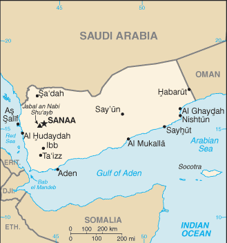
Location: Middle East, bordering the Arabian Sea, Gulf of Aden, and Red Sea, between Oman and Saudi Arabia
Geography note: strategic location on Bab el Mandeb, the strait linking the Red Sea and the Gulf of Aden, one of world’s most active shipping lanes
Land boundaries: Oman 294 km, Saudi Arabia 1,307 km, total: 1,601 km
Maritime boundaries: Gulf of Aden, Red Sea
Coastline: 1,906 km
Area: total: 527,968 sq km; land: 527,968 sq km, water: 0 sq km (total 203 849,50 mi2), almost four times the size of Alabama; slightly larger than twice the size of Wyoming.
Roadways: total: 71,300 km, paved: 6,200 km, unpaved: 65,100 km (2005)
Waterways: N/A
Local time (capital): UTC+3, 8 hours ahead of Washington DC during Standard Time
Note to the local time: N/A
Population in Yemen: 28 915 284
Population in Sanaa: 2 419 000 (including the metropolitan areas)
Urbanization: urban population: 34.6% of total population (2015)
Major urban areas population: SANAA (capital) 2.962 million; Aden 882,000 (2015)
Population growth rate: 2.37% (2016 estimate)
Birth rate: 29.2 births / 1,000 population (2016 estimate)
Death rate: 6.1 deaths / 1,000 population (2016 estimate)
Age structure: 0-14 years: 40.48% (male 5,639,657 / female 5,447,662) 15-24 years: 21.16% (male 2,940,484 / female 2,855,538) 25-54 years: 31.79% (male 4,451,305 / female 4,257,877) 55-64 years: 3.87% (male 487,986 / female 571,676) 65 years and over: 2.7% (male 342,053 / female 398,541) (2016 estimate)
Median age: total: 19.2 years; male: 19.1 years, female: 19.3 years (2016 estimate)
Ethnic groups: predominantly Arab; but also Afro-Arab, South Asians, Europeans
Religions: Muslim 99.1% (official; virtually all are citizens, an estimated 65% are Sunni and 35% are Shia), other 0.9% (includes Jewish, Baha’i, Hindu, and Christian; many are refugees or temporary foreign residents) (2010 estimate)
Government type: Republic
Legal system: mixed legal system of Islamic law, Napoleonic law, English common law, and customary law
National anthem: United Republic
Known national hazards: sandstorms and dust storms in summervolcanism: limited volcanic activity; Jebel at Tair (Jabal al-Tair, Jebel Teir, Jabal al-Tayr, Jazirat at-Tair) (elev. 244 m), which forms an island in the Red Sea, erupted in 2007 after awakening from dormancy; other historically active volcanoes include Harra of Arhab, Harras of Dhamar, Harra es-Sawad, and Jebel Zubair, although many of these have not erupted in over a century
Major infectious diseases: The degree of risk(s): high food or waterborne diseases: bacterial diarrhea, hepatitis A, and typhoid fever vectorborne diseases: dengue fever and malariawater contact disease: schistosomiasis (2016)
Land use: agricultural land: 44.5%; arable land 2.2%; permanent crops 0.6%; permanent pasture 41.7%; forest: 1%; other: 54.5% (2011 estimate)
Agricultural products: grain, fruits, vegetables, pulses, qat, coffee, cotton; dairy products, livestock (sheep, goats, cattle, camels), poultry; fish
Industries: crude oil production and petroleum refining; small-scale production of cotton textiles, leather goods; food processing; handicrafts; aluminum products; cement; commercial ship repair; natural gas production
Export commodities: crude oil, coffee, dried and salted fish, liquefied natural gas
Main export partners: China 24.5%, UAE 16.5%, South Korea 10%, Saudi Arabia 10%, Kuwait 9.1%, India 8.5% (2015)
Import commodities: food and live animals, machinery and equipment, chemicals
Main import partners: UAE 20.9%, China 14.3%, Saudi Arabia 9.9%, Kuwait 7.4%, India 4.6% (2015)
Navigate the countries in Middle East faster and easier while driving, use the interactive Google maps for your driving directions. The continuously updated database contains over 220 countries and territories digitally mapped, hundreds of millions of businesses and places around the world positioned on the map.
Get fresh GPS navigation, traffic, and transit information – no matter what part of Yemen, Sana’a, any other city and country in Asia, or the world you’re in.
Do you like this Yemen information page? Please don’t forget to share it with others! Thank you.
16 thoughts on “Yemen”
Comments are closed.