Angola Google maps and Driving Directions
Get free driving directions, Google maps, traffic information for Angola, and Luanda (GPS: 8 50 S 13 13 E), the capital city of the country located in (the) Southern Africa, bordering the South Atlantic Ocean, between Namibia and Democratic Republic of the Congo.
Find any address in Luanda on the Google map of Angola (AO) with ease or calculate your up to date itinerary to and from Angola or its neighboring counties like Democratic Republic of Congo, Namibia, Republic of the Congo, Zambia.
Sightseeing and exploring in Africa starts here, thanks to Google because its Earth Engine combines a multi-petabyte catalog of updated satellite imagery and geospatial datasets with planetary-scale analysis capabilities. Wonder the world, use the satellite map function of the Google maps to explore or see differences on the Earth’s surface, inland, or the surrounding areas of Angola.
Google Maps Angola
Located in southwest Africa, Angola suffered a civil war following independence from Portugal in 1975, until a 2002 peace deal. Hundreds of thousands of people died.
Angola is narrow coastal plain rises abruptly to vast interior plateau.
The map above fully covers Angola with its road routes from cities to towns, road intersections in any region, provinces, prefectures, also with free driving directions in Luanda or to the neighboring towns and countries. To look at the detailed map about a particular quarter in Luanda, please click on the area and zoom to the place you are interested in the Google maps of Angola (AO).
Be creative, use the extras of this Google map; This is a detailed, clear, zoomable, large road map of Angola with its administrative divisions; 18 provinces (provincias, singular – provincia); Bengo, Benguela, Bie, Cabinda, Cunene, Huambo, Huila, Kwando Kubango, Kwanza Norte, Kwanza Sul, Luanda, Lunda Norte, Lunda Sul, Malanje, Moxico, Namibe, Uige, Zaire.
The interactive map above is also may be used as the satellite map of Angola, or as a reverse search map for finding an address from its GPS coordinates.
Angola, more than three times the size of California, extends for more than 1,000 mi (1,609 km) along the South Atlantic in southwest Africa. The Democratic Republic of the Congo and the Republic of Congo are to the north and east, Zambia is to the east, and Namibia is to the south. A plateau averaging 6,000 ft (1,829 m) above sea level rises abruptly from the coastal lowlands. Nearly all the land is desert or savanna, with hardwood forests in the northeast.
Angola (area: 1 246 700 sq km / 481 353,36 sq mi), where the official language is Portuguese, lying in Africa and using the currency; Angolan kwanza (AOA), since 1977, set their clock to UTC+1. That means they are 6 hours ahead of Washington DC during Standard Time in Luanda, the capital. Note to the time difference: N/A.
The climate in Angola; Varies from temperate to tropical. Rainfall decreases north to south. Coast is cooler and dry.
Geography in a nutshell; Most of the land is hilly and grass-covered. Desert in the south. Mountains in the center and north.
Click here for more detailed information about Angola.
Driving directions Angola
The Google maps and Google Satellite maps of Angola above showing the country, located next to Democratic Republic of Congo, Namibia, Republic of the Congo, Zambia. For your further reference, the latitude and longitude coordinates of Angola are 12 30 S, 18 30 E , while the capital, Luanda found at 8 50 S 13 13 E.
When you are traveling around Angola, Luanda, or its other cities, use this routing tool, providing up to date route planning service free of charge.
Look no further; get accurate driving directions in Angola, Africa, by filling the route planner form below.
Since Google acquired and introduced its digitalized maps in 2004, you’re probably familiar with its base functions, like finding an address or driving directions to locations. Still, Google maps also accommodate bicyclists, pedestrians, and also public transportation with special directions and customizable routes.
About Angola and the capital, Luanda
 |
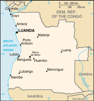 |
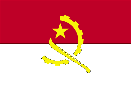
| The national flag of Angola | Borderline map of Angola |
| Flag description: two equal horizontal bands of red (top) and black with a centered yellow emblem consisting of a five-pointed star within half a cogwheel crossed by a machete (in the style of a hammer and sickle); red represents liberty, black the African continent, the symbols characterize workers and peasants. | Border length: total: 5,369 km. Border countries (total: 4): Democratic Republic of the Congo 2,646 km (of which 225 km is the boundary of discontiguous Cabinda Province), Republic of the Congo 231 km, Namibia 1,427 km, Zambia 1,065 km. |
Did you know about Angola?
- Originally a Portuguese colony, Angola eventually liberated by the Peoples Liberation Movement of Angola in 1975.
- Angola has the greatest number of amputees (caused by landmines) in the world.
- This tiny nation is unique in having two joint heads of state-the President of France and the Bishop of Urgell in Spain.
Facts of Angola (AO)
Name conventional long form: Republic of Angola, conventional short form: Angola, local long form: Republica de Angola, local short form: Angola, former: People’s Republic of Angola, etymology: name derived by the Portuguese from the title “ngola” held by kings of the Ndongo (Ndongo was a kingdom in what is now northern Angola)
Codes: ISO; AO, Internet; .ao
Capital city: Luanda
Language(s): Portuguese 71.2% (official language), Umbundu 23%, Kikongo 8.2%, Kimbundu 7.8%, Chokwe 6.5%, Nhaneca 3.4%, Nganguela 3.1%, Fiote 2.4%, Kwanhama 2.3%, Muhumbi 2.1%, Luvale 1%, other 3.6%. Note: most widely spoken languages; shares sum to more than 100% because some respondents gave more than one answer on the census (2014 estimate)
National holiday(s): Independence Day, 11 November (1975)
Motto: Virtus Unita Fortior (United virtue is stronger)
Currency: Angolan kwanza (AOA), since 1977
GPS: 12 30 S, 18 30 E, Luanda; 8 50 S 13 13 E
Location: Southern Africa, bordering the South Atlantic Ocean, between Namibia and Democratic Republic of the Congo
Geography note: the province of Cabinda is an exclave, separated from the rest of the country by the Democratic Republic of the Congo
Land boundaries: Democratic Republic of the Congo 2,646 km (of which 225 km is the boundary of discontiguous Cabinda Province), Republic of the Congo 231 km, Namibia 1,427 km, Zambia 1,065 km, total: 5,369 km
Maritime boundaries: N/A
Coastline: 1,600 km
Area: total: 1,246,700 sq km; land: 1,246,700 sq km, water: 0 sq km (total 481 353,36 mi2), slightly less than twice the size of Texas.
Roadways: total: 51,429 km, paved: 5,349 km, unpaved: 46,080 km (2001)
Waterways: 1,300 km (2011)
Local time (capital): UTC+1, 6 hours ahead of Washington DC during Standard Time
Note to the local time: N/A
Population in Angola: 30 774 205
Population in Luanda: 2 297 200 (including the metropolitan areas)
Urbanization: urban population: 44% of total population (2015)
Major urban areas population: LUANDA (capital) 5.506 million; Huambo 1.269 million (2015)
Population growth rate: 2.72% (2016 estimate)
Birth rate: 38.6 births / 1,000 population (2016 estimate)
Death rate: 11.3 deaths / 1,000 population (2016 estimate)
Age structure: 0-14 years: 42.72% (male 4,394,206 / female 4,223,246) 15-24 years: 20.72% (male 2,127,140 / female 2,053,363) 25-54 years: 29.6% (male 3,013,561 / female 2,956,547) 55-64 years: 3.97% (male 388,314 / female 413,347) 65 years and over: 2.99% (male 278,853 / female 323,755) (2016 estimate)
Median age: total: 18.2 years; male: 18 years, female: 18.3 years (2016 estimate)
Ethnic groups: Ovimbundu 37%, Kimbundu 25%, Bakongo 13%, mestico (mixed European and native African) 2%, European 1%, other 22%
Religions: Roman Catholic 41.1%, Protestant 38.1%, other 8.6%, none 12.3% (2014 estimate)
Government type: Unitary presidential constitutional republic
Legal system: civil legal system based on Portuguese civil law; no judicial review of legislation
National anthem: Angola Avante (Onwards Angola)
Known national hazards: locally heavy rainfall causes periodic flooding on the plateau
Major infectious diseases: The degree of risk(s): very high food or waterborne diseases: bacterial and protozoal diarrhea, hepatitis A, typhoid fever vectorborne diseases: dengue fever, malariawater contact disease: schistosomiasis animal contact disease: rabies (2016)
Land use: agricultural land: 47.3%; arable land 3.8%; permanent crops 0.2%; permanent pasture 43.3%; forest: 46.8%; other: 5.9% (2011 estimate)
Agricultural products: bananas, sugarcane, coffee, sisal, corn, cotton, cassava (manioc, tapioca), tobacco, vegetables, plantains; livestock; forest products; fish
Industries: petroleum; diamonds, iron ore, phosphates, feldspar, bauxite, uranium, and gold; cement; basic metal products; fish processing; food processing, brewing, tobacco products, sugar; textiles; ship repair
Export commodities: crude oil, diamonds, refined petroleum products, coffee, sisal, fish and fish products, timber, cotton
Main export partners: China 43.8%, India 9.6%, US 7.7%, Spain 6.2%, South Africa 4.8%, France 4.4% (2015)
Import commodities: machinery and electrical equipment, vehicles and spare parts; medicines, food, textiles, military goods
Main import partners: China 22.1%, Portugal 13.8%, South Korea 11%, US 6.9%, South Africa 5%, UK 4.1%, France 4% (2015)
Navigate the countries in Africa faster and easier while driving, use the interactive Google maps for your driving directions. The continuously updated database contains over 220 countries and territories digitally mapped, hundreds of millions of businesses and places around the world positioned on the map.
Get fresh GPS navigation, traffic, and transit information – no matter what part of Angola, Luanda, any other city and country in Africa, or the world you’re in.
Do you like this Angola information page? Please don’t forget to share it with others! Thank you.